Hurricane Harbor

A writer and a tropical muse. A funky Lubavitcher who enjoys watching the weather, hurricanes, listening to music while enjoying life with a sense of humor and trying to make sense of it all!

Tuesday, July 31, 2018

Tropics Quiet Today. Life Goes On. Get Ready for a Busier Time in August. FIU PROUD :)


I know I've been out of it lately or rather taking a break from posting on the tropics as I've been on vacation and the tropics have been pretty dead. As many of you know I've been in Miami where my youngest son graduated last night from Florida International  with a Masters in Architecture. This is the same son that was in China participating in a program this summer at Tongji University in Shanghai; he certainly gets around. Glad he's home and it was wonderful to celebrate with him and the family as he passed this milestone in his life as he sets out on his chosen career. I wanted him to go to NC State in Raleigh where they have a great Architecture program but being his mother's son he loves Miami and said he needs to lean how to build for hurricanes and FIU is the best place to do that. I graduated from FIU so it's even more sweet to come back and watch my son do so as well. Like my "little" son, my old college has grown up as well and it's impressive as it is now one of the higher ranked Universities in the country. It also is where the National Hurricane Center is located so well you knew I'd bring this back to hurricanes didn't you? His architecture class actually got a tour of the NHC building and complex; thank you to those involved in that nice field trip across the campus.

There are none in the Atlantic Basin today. There aren't even any Tropical Storms or Tropical Depressions and the models aren't even waxing poetic on possible hurricanes so I took a good time to take a vacation. If you don't believe me you can look at the models yourself below. Not much to see.

http://moe.met.fsu.edu/tcgengifs/

There are very long term models that suggest tropical development will begin later in the first week of August going into the second week but they are stabs in the dark and yet they are in line with Climo so know that hurricanes are out there down the road and waiting to take their turn onto the stage.

So many people wonder this time of year while they wait for the season to find it's groove and some seasons are much like this season where something sputters up early and then things die down while we wait for the real season to begin. Putting up a link below to a site by someone who over the years... I've come to enjoy reading his thoughts. For those of us who have been online for a long time we have long memories and well that's all I'll say.

https://www.cyclonicfury.com/2018/07/31/cyclonic-furys-final-2018-atlantic-hurricane-season-forecast-slightly-below-average-activity-anticipated/

There are many people, agencies and organizations that put out updates for the Hurricane Season. Giving you the link to one above that is easy to read and lays out for you in a more compact (but detailed form) the reasons we think this may be a less than active hurricane season. I'm calling it "normal" whatever that means personally (average is such a vague word) and many are calling it a bit below "average" or "normal" so you can read up on this while I finish my Florida vacation.


It's a good read.
It's going to be a real season.
At some point down the road.

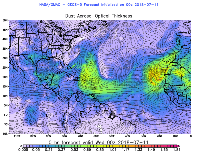
It's hard to say exactly where and when a hurricane will threaten some town this year, but even in quiet seasons the threat is always there and hurricanes always appear. I don't like forecasting numbers and making predictions that way because it's a story that has not been written and we are just beginning the chapter called "Prelude to September" and that doesn't count out late August or early October. You can see from the image above there are well defined tropical waves moving West. The loop below shows the process where waves get stronger and remain intact crossing the Atlantic despite the dusty, dry Saharan Layer that reigns in June and July and wanes in August and September. That's why the Atlantic comes alive in September.

hiatlsat_None_anim.gif (768×496)

There is nothing expected for form but I would not put it past the tropics to offer up some close in, home grown system along the SE coast over the next few weeks while we wait for the waves to be viable. With this much convection lingering over warm waters pressures tend to lower and trouble can begin to brew up somewhere. So never shut the lid on the tropics because they are quiet, just check back every day or twice a day to make sure something surprising doesn't spin up when you least expect it. Models are not perfect, they are getting better over time but prone to missing small systems that spin up fast along the coast. There are always possibilities even when they get very little press before developing. 2018 has been a year of surprises so I'd expect to be surprised.


Note the purple and blue in the Atlantic.
Also over the GOM.
Don't let your guard down.

As for some family pride as well as Panther Pride I'll add here many people were responsible for helping to raise my youngest son aside from me.. his mother...who worked very hard sometimes at two jobs while still managing to have a life and study the tropics and write about them. While attending the Hebrew Academy on Miami Beach my youngest son stayed in Miami at my brother's house and then continued living there through college. My daughter-in-law's parents live out near FIU and they had him sleeping there by their house many nights when he left the Architecture Lab at 3 AM before going back to classes at 9 AM and I really do owe them even though they always say they "barely noticed him" but I know they kept his favorite snacks in the house and made him feel loved and cared for as well. 

Being the youngest of a large brood of kids is never easy as every other older sibling thinks they are "in charge of you" and "knows more than you" and the kid who was put into gifted early on at Greynold's Park Elementary when they told me "your son is very smart" at a late night parent teacher meeting where for some reason his teacher seemed to want me to know that fact as if I didn't realize it but as a child he loved cars, NASCAR and rock music. He had some vibrant older teenage siblings and their friends always coming and going. At his Bar Mitzvah his brother's arrived with their friends and they looked like the mob had walked in to a Hollywood movie with a Bar Mitzvah scene. Other older siblings lived far away in New York in Crown Heights and other places yet my youngest son and his close siblings grew up in Miami and Miami is a wonderful place to grow up... and grow up they did.


My brother and his nephew.
Or as he likes to call him..
"his partner in crime"
They've traveled together many places...
...many Marlins games ;)


My son Moe proud to watch him graduate.

Me and Zalmy at a wedding last year...
..wedding for his older brother Mendy.


You want to hold onto them forever.
But then they go out... and discover the world.
They travel to Spain and Germany and Shanghai.
They walk the Great Wall of China.
But they always come back to Miami.


He was actually a Season's Ticket Holder one year!
My son... his name is up on the wall.

His sister posing with him.
His older brother Moe taking pictures.


Sometimes life seems to move slowly, day by day, and it feels as if you are getting no where fast. Thunderstorms pop up in the afternoon and summer slowly moves towards the football season and dreams for the Miami Dolphins to rise up once again . . . and hurricanes begin to roll westbound across the Atlantic while we watch and wait to see what will happen. My father used to always say to me "you got to do what you got to do" and I did and so do my kids. So should we all... 

Just as my son knew that if he wanted to live and work in Miami he would need to know how to build for the Hurricane Season so to do all of us who live in Hurricane Country need to remember that those busy days are out there even while Mike is on a cruise and I'm in Miami in my daughter's bed under the big poster of Audrey Hepburn in Breakfast at Tiffany's I know that this is the quiet time, a day to relax and remember and enjoy the memories. Soon I'll be back on the road back to North Carolina a place I truly do love even though it's different from Miami. I've always been good at loving different places and different people ... appreciating the beauty in people and places the way my son appreciates the angles of buildings and landscapes. 


This is his explanation of what he did this summer.

What do you love?
What's your passion?
Follow it.
Do what you got to do.

Besos BobbiStorm
@bobbistorm on Twitter

Ps... I'll be back as soon as something happens in the tropics.
You can bet on that.


Labels: , , , , , , , , , ,

Wednesday, July 25, 2018

Watching & Waiting. Close In Drama and Strong Tropical Waves. Mid Atlantic (Baltimore to NY) Needs to Worry on This Hurricane Season. Rain Tends to Bring Canes.


The NHC may say NO NO NO
But still we watch the tropics.
Best place to watch is Spaghetti Models.
Find your favorite product of the day.
Above highlighted is....
..areas the government highlights for possible development.
As we move towards August 1st...
...things heat up.
So now is a good time to prepare.
My favorite thing to buy for Hurricane Supplies?


1 lesson from Hurricane Andrew.
I wanted coffee more than water.
Miami girl... needs her cafecito.
Starbucks makes one too.

I don't really have time today to blog but I'm blogging just the same. Why you ask ...as the tropics look so dead? They aren't dead they are in "set up mode" kind of like a possum playing dead so he conserves his energy for when he needs it.

latest72hrs.gif (947×405)

Look at that shadow effect from the last wave.
Still there. 
Took a bit bite out of SAL.
Leaves it a kinder place for the new wave.


SAL is still there but wilting a bit under the nonstop attack from one tropical wave after another, each wave juicing up the atmosphere just a bit more each day. The wind flow pattern begins to change and as the sun begins to warm up the cooler water that once was there the tropical Atlantic becomes more favorable for tropical development. Each dying wave flares up just a bit more further West as they approach South America. Eventually one, like Beryl develops but unlike Beryl it will be easier to find on satellite imagery. Contrary to hype and repetitive news stories the 2018 Atlantic Hurricane Season is not dead, not a goner and it will not succumb for a while to El Nino that really is still picking out his outfit for his big debut on the weather stage.


2018 so far.
A huge Bermuda High is outlined above.

The Bermuda High breathes much like you and I do. It has it's good days and it's weaker days and sometimes it feels unstoppable. It inches West, it slides back to the East, it retrogrades back towards the West and then it moves back a drop more; the location of the High is everything when a hurricane is moving WNW towards the Caribbean and the East Coast. If it becomes a double barrel high than places in the Gulf of Mexico need to worry more than normal. As much as we watch the waves we have to watch the High Pressure that becomes their steering current and ticket to the New World. Think of those waves like Christopher Columbus going on a voyage westward. 


Two things to think on.
On rare occasions ULLs can work their way down to the surface.
Especially this year where we are used to storms like Chris.
Close up below.
As areas sit over warm water...
...they need to be watched.
Tail end of dead fronts need to be watched.


Number 2... 
They go where the low pressure is.
Most basic Cliff Noes there.
They try and avoid the High.
They go where the Low Pressure is...


That is where the Low Pressure is and has been.
Mid Atlantic with record levels of rain.
The ground already soaked and soggy.


As I said on Twitter...
we hope this does not play out..
...but it could.
Currently the Mid Atlantic is a magnet for weather.

Off the coast of Africa.


Our huge wave is exiting.


Finding a friendlier environment that earlier waves.


Something to keep in mind.

This year the East Coast is at higher risk than most places to have a landfalling hurricane. That doesn't mean they will get one, they could get lucky suddenly, but the threat is there as we are in a similar pattern to 1985 and 2012 ... years that produced Gloria and Sandy so beware.

Personally I'm packing today and on my way back to Florida for a while. My youngest son who keeps a low profile on social media unless he is posting pictures of far away places and incredible architecture is graduating from FIU with a Masters Degree in Architecture. Yes, I'm proud as he worked very hard and though we knew he could and would do it ... it is still a huge accomplishment. His older brother who is often on social media is "taking over the Compass Realty" Instagram site for the day before he sails off somewhere as Meyer boys are always flying off somewhere while their Momma is traveling the East Coast going back and forth from Raleigh to Miami. This picture below is from his wedding day as the official Mother and her son picture. 

He knows Miami and it's various neighborhoods better than anyone as he was raised on Miami Beach. No one knows the best streets, places and views of Miami Beach than a Miami Beach native. He's also the 5th generation who has worked in Florida Real Estate, this is really a no-brainer when it comes to finding a good agent to sell your property or help you find the right property. If he could sell an empty lot for close to 7 Million Dollars think what he could sell your waterfront mansion for or your beautiful, much loved home on Royal Palm Avenue on Miami Beach. He lives in Coconut Grove he knows every nook, road and home with the prettiest palm trees or the most beautiful jogging path down to the bay. He's my son. 


Yup when you grow up in paradise.
You know all the best places in paradise ;)


Loved that house ..
The house we safely rode out Hurricane Andrew in..
Built like a rock.

Besos BobbiStorm
@bobbistorm on Twitter

PS Please read yesterday's post.
It explains what you need to think on well


Enjoy the video a close friend sent me as a hurricane cruised by Miami.
Happens and life goes on.
2 blocks from where Levi grew up.
I love that view.
Would love to live there with that view.
Maybe some day.
Isn't great to have good friends?
Miami Beach is really a small town inside..
..a tourist's dream novel.
A great, wonderful place to live, work and play.


From Tower 41 on 41st Street on Miami Beach ;)Wat


Labels: , , , , , , , , , , , ,

Tuesday, July 24, 2018

Mid Atlantic Under the Gun This Year from Wicked Weather. Will A Hurricane Come It's Way Too? Too Soon to Say But Signs From the Past Point to Tropical Trouble.


hiatlsat_None_anim.gif (768×496)

This is where we are this morning. A big, colorful tropical wave prepares to leave Africa. A suspect area of convection will flare up as the sun gets higher in the sky in the Gulf of Mexico. A long trail of deep tropical moisture runs from Florida up to Canada. The area most under the gun is the Mid Atlantic northward including a good part of the Carolinas. Florida will get more rain than usual from the GOM as it moves about in tandem in flow with the whole shebang that is messy and busy and everyone wants it to go away. It will go away, but it will be replaced with stronger waves and developing storms so are you ready for the Hurricane Season? I'm guessing if you are reading this you are more ready than the Average Joe. Note the white area of convection ahead of the new wave that loops like a leaping dolphin. That will allow this wave to stay alive longer than the last strong wave that tried to flare up just before it rolled onto the coast of South America. 

The rains in Pennsylvania and New York will create havoc and when I say havoc I mean water rescues and property under water and the water is going to keep rolling downstream to the lowest point and then it may keep rolling. Rivers will rise. What starts in PA often ends downstream in DC, Maryland and parts of Virginia. The Mid Atlantic really is in a set up going into the hurricane season that isn't pretty and way too welcoming for any tropical system pushed westward too close to the coast by a large persistent Atlantic High. Note the map below by Cranky of the current set up. The current set up is waiting for a system from Canada to finally move in and rearrange the flow. The problem with this set up is if it hangs around in any way and you throw a tropical marble into that pattern it only brings more trouble to the Mid Atlantic. When I harp on the Mid Atlantic it is because it's not a good set up for them this year, but anywhere along the coast from the GOM to Florida has to watch carefully when the Bermuda High breathes, expanding in then out then in again. Highs do that they remain anchored but they float around a bit near that anchor and every degree it pushes West or East means escape or landfall for a hurricane.


Nothing stays the same though there are commonalities. In the same way that we are young and then we get older, some of us get wiser and some of us don't... the story is in the telling. A young hot looking guy who enjoyed playing sports turns into a fat slob from drinking too much beer and eating too many chips while watching sports and is too tired to get up to go to the fridge to get another beer. His wife who was a hot young thing before she had 3 kids and cut her long blonde hair short because it was easier has to shop at a large size store and wanders in and out of Weight Watchers trying to lose that extra fifty pounds. She gets him the beer, she plays Candy Crush and nibbles on M & Ms which is a far cry from what she used to nibble on back when they met. Life's not bad for the aging happy couple but it's not what it was and neither are they. You think I'm depressed right? Nah.. being playful.

So you have this set up with the High Pressure and Cousin SAL is the hottest guy in town. He blows out hot Saharan Dust lighting up the sunsets in tropical hues and everyone thinks he's their hero. Lord knows we all need heroes. After the 2017 Hurricane Season people will take any hero they can get to go through that again. We grasp at heroes named SAL or "Cooler Water Temps" (It's just a bit cooler? No problem we'll take it!!) or the always popular EL Nino. But no matter how bulked up Cousin SAL is at some point he begins to get tired of dealing with the incessant, insidious tropical waves and he's not getting as much support from his friend "cooler waters" like he did earlier in the season and by late August Cousin Sal becomes a really big sloppy mess. El Nino comes in like the Trojan Horse ready to save the day (a dollar short and way too late by the way) and delivers what could be crappy weather to many parts of the country that will then be blamed on El Nino that goes fast from friend to foe. 


I'm pretty sure that old Homer was probably pretty hot when he was young, I mean his wife is still pretty hot in a Smurfy kind of way with the blue hairdo. But I think you get where I'm going with this in that things evolve and what is on the weather maps today evolves into a bigger problem during late August and early September. I do think in fact we will have something to talk about the first week of August in the Atlantic but either way the area close in that gives us Home Grown could produce a named system or a pain in the rear end no name storm that brings strong weather and more flooding rains to some area along the coast. Keep watching. For now SAL is strong and so is the moisture feed running out of control until some Canadian front pushes down and it being July doesn't help much as it's a bit early for that, however I have leaves on my Maple tree in Raleigh that are beginning to turn yellow so I'm guessing we are just running fast and furious towards Fall this year.

Mid Atlantic. 
Keep it mind.
Today and down the road.


In Raleigh this big beautiful pecan tree came down.


Beautiful house.
Beautiful tree.
Withstood many a hurricane.
But it came down from a strong storm.
Maybe it was tired.
Maybe just the storm was strong.


What is it about people that makes them get crazy hysterical about some one online or leads to road rage when cut off but we cry when we see such a beautiful old tree that came crashing down. Anyway... I suggest you learn the differences in the Flood Watches and Warnings that the NWS puts out so linking to an article below that is worth you taking the time to read. Do you really know what an AREAL FLOOD is or do you think it means it's a real flood? Wrong. Please read especially if you live near a stream that is high or in an area already water logged from recent rains.


http://www.weatherboy.com/different-flood-types-advisories/

Do you really know the differences? Now would be a good time to learn them and be aware of the specifics your area might be dealing with during the next few days while tropical convection keeps being pumped up over a good swath of the East Coast. That said, places out West had flooding today also so it's a lesson everyone needs to learn because even in a desert there is sometimes rain.

Knowledge is power. I say that all the time here and in person and it's true.

I'll be back when there is something to report or to make an update. I'm in pre travel mode as I'm preparing to go back to Florida for a little while for some family happenings and I'm sure the photos in my blog will reflect that change of scenery. Keep smiling, stay alert and enjoy the quiet times if you are not under the gun from wicked rain storms.

Besos BobbiStorm
@bobbistorm on Twitter
Not proofing this so if I made a mistake... sorry and I'll fix it later.

https://www.npr.org/2014/09/19/349621429/the-song-that-never-ends-why-earth-wind-fires-september-sustains Interesting article about a song about the 21st of September... the peak of the Hurricane Season. Will we be tracking??

Ps Using that knowledge you have to know that the Saharan Dust will eventually give it up to moist, tropical waves and the shear zone gives way to kinder aspects for those tropical waves trudging Westbound. 1985 and 2012 had similar set ups and they both had impacting hurricanes along the Mid Atlantic. If you aren't familiar with hurricane history then look up the names Gloria and Sandy. That is why I worry as our set up this year mirrors similar set ups, however the monkey wrench is that every hurricane season is just a little bit different from the analog one.


Labels: , , , , , , , , , , ,

Friday, July 20, 2018

Tropics Quiet. Coastal Low Moves Up Towards SNE. Carolina Getting Swamped With Rain. Twin Twisters Dance on the Plains (Iowa not Oklahoma) and SAL Lunges West Again as Waves Keep On Coming. Check with NWS Before You Make Your Weekend Plans on the East Coast


Just to stay grounded here...
NHC 8 AM


Nothing tropically to talk about.
Much discussion on a coastal low today.
Remember that GOM coastal system...
...never got a name but lots of rain?
Sort of a similar set up in NE.
SNE to be exact.
Long Island
Rhode Island.
Cape Cod.

But the real story today is Down South.
What starts down south doesn't stay there...


Note the long draped cold front that went flat and is now a rain front of sorts ( I made up that term) and it's raining, flooding, pouring across parts of South Carolina. Oddly they have had a rainy area off the coast for days in one way or another from Charleston up to Myrtle Beach to Wilmington. They have been a real rain magnet this past week. Now at some point the rain wraps up and moves it up the coastline; some models show it hovering over the coast vs off the coast. Had this system sat and lingered for a few days over tropical waters we might have gotten some sort of Chrissy storm system but it's on the move as if it's on a summer vacation bound for the great beautiful NE. My mother did that one year, she insisted we drive to New England for the only real vacation we ever took. All the places I really had no interest in seeing such as Williamsburg VA as she was into Colonial stuff and then onward to NE so she could see what Yale looked like (why Yale vs Harvard I don't know) and understand I had to sit in the back seat of a small car as a teenager between two little fighting brothers. This really totally made no sense. Looking back it never made sense and it was the one summer of my life I wanted to stay in South Florida. 

The hype I have read online makes no sense. People keep asking me if it will get a name. And, in truth the NHC that has been writing great discussion on waves and the tropics but they could do anything as the last few years they do things out of context with their general past pattern of doing things. Maybe next year they will make up a new storm name "Possible Tropical Weather System" known on the maps as PTWS for those storms that everyone wants to know why they are not naming and putting out forecasts for...

That's what the National Weather Service is for...

If this goes tropical or extratropical or subtropical they will be all over it immediately.
Feel free to save this link where the NHC talks about things not seen on their map page.


What is interesting is that we have fronts; one front after another progressing across the country and down into the Deep South in July. We also have a huge, strong High Pressure area that currently is propelling SAL into our cities providing colorful sunsets and health alerts for people with breathing problems.  You can see the SAL being propelled West below on the right side of the loop below. Again I'll remind you later in the season hurricanes can and often go where the SAL went especially in the earlier part of the season in August. 


hicbsat_None_anim.gif (768×496)

As for the weather mass ...
... you can see where it's going.
Prepare to spend the weekend at the Mall.
Maybe a movie?
Redecorate?

allfcsts_loop_ndfd.gif (799×559)


Basically the whole East Coast is gonna be messy.
Plain and simple.
Some places are going to be messier.
Rain is needed but...
Pain on the weekends.
No one wants rain on the weekend.
I actually don't mind it.
I don't like when it remains around for days.
I'm going to Florida this coming week.
Looks like rain.
Summertime.

And not going to ignore the incredible outbreak of tornadoes in Iowa yesterday. Some of the most incredible video I've seen in a long time and I've seen a lot of great storm chasing videos. You don't see that every day unless it's a badly made Hollywood movie that plays often late at night. Not talking Twister that if it was up to me could play every day and all night on some channel somewhere.


Even Hollywood wouldn't think to put that ...
...into the Wizard of Oz.


As for tropical waves.
They are there and healthy.
But then they hit SAL.
At some point this changes.

geos5_AOT.gif (800×618)

It's an atmospheric ballet....
Waves pulse up and cut into the SAL.
SAL wins out eventually.
Next wave comes off ...
...it begins again.


Think of them as dancing.
Waves dancing with Cousin SAL ;)

Excellent tweet.
Love someone who knows how to look at the long view.

Cliff Notes.
Week 1...


Please add him on Twitter.
Especially if you want to see Week 2 and 3..

Stay tuned and please watch the weather.
Weather happens very fast in the summer.
Over lakes, over plains and by the coast.


Check out your local weather this weekend..
...and every weekend.
Before going out on the lake..
..or to the beach.

Besos BobbiStorm
@bobbistorm on Twitter

Ps... Think of SAL as the BEAST.


Watch that loop.
They actually kind of dance with each other.
At some point SAL gets tired.
Winds shift...
Patterns flip.
Things change.


Labels: , , , , , , , , , ,

Monday, July 16, 2018

Turning the Calendar Moving Towards the End of Summer. Looking Towards August and September? Sales, Amazon Prime. Shop for Hurricane Supplies


I just want to put a few thoughts in your heads today and maybe you will think on them a bit more seriously. I know it's hot in many places and it's been hot for a while now and it feels like the heat is never going to end. It's going to end and even now as we can see cool fronts have made it down into the Carolinas enough for the heat to mitigate and go out on a late night ice cream date. A few weeks back there was no time or hour that anyone wanted to leave the AC behind to venture outside. Day by day we get closer to Fall as we have turned the corner on the longest day of the year and are working our way back. Nothing says "summer" on it's way out than the reality that "Summer Stuff" is on sale more than 50% off in every department store.

You must have wondered why I put shorts, beach bags and sandals on my page vs the regular snapshots of the usual suspects in the tropics. There aren't many usual suspects today as Post Tropical Subtropical Storm Beryl exits our side of the world. The NHC really loves to give tags to things vs just calling it Beryl as a storm by any name is still a storm. But it's always good for officials in responsible branches of the government to be picayune about the details. Models play with a wave that will exit Africa and another model shows development down in the deep Caribbean. Closer to home the reality of that aforementioned cool front that died off the coast tossing us up a surprise is more likely as shear in the Caribbean has so far been a killer to development in that part of the basin.


You can see the fronts moving down.
The dry spotted dusty zone.
Usual suspects are there.
But 2018 has been filled with surprises.
Expect the surprises to continue.

And now is a very good time to look down the road.
To look down the tropical road.


This map above was put out by Crown Weather and it's a great map to think on. Add in the reality of this season so far and understand as tropical waves get more viable and the Bermuda High gets stronger the future tracks of storms will be closer to the coast than Beryl and Chris.


In theory the following storms will follow the same similar pattern set by the early storms of 2018, however they will come closer to the coast and more likely flirt with landfall; actually they will most likely make landfall somewhere. The high latitude constant development of severe weather goes on and I'm concerned about the Mid Atlantic area to the NE being at a higher risk than normal. Normally around August 15th we really have to watch the Atlantic. I believe we are running a bit ahead of schedule so we should start watching the Atlantic in about 10 days or so (remember I said surprises happen) to see some subtle shifts as we transition into the real part of the Hurricane Season. 

So if you have deals on Amazon Prime this week or your local store is selling off it's summer supplies such as BBQ grills that might come in handy if you lose power as they want to bring in their fire pits for the backyard... you might want to think on your priorities. Nothing says we are getting closer to the Hurricane Season and it's distant cousin NFL Football than sales on summer going at up to 70%.

Make good use of the quiet time, enjoy what's left of the summer and remember to stock up on hurricane supplies as you may need them as we get closer to September.

Besos BobbiStorm
@bobbistorm on Twitter

Ps... Crown Weather is one of the best, most reliable and least likely to hype any weather event, yet at the same time properly prepares you for what might impact you region. It's a paid site unlike www.spaghettimodels.com but he goes deep into discussion on what really is happening in the tropics and otherwise.

I'm not going anywhere but it's a great song and very good to remember. Because tropical systems may be unwanted guests come September.


Labels: , , , , , , , , , , , , ,

Saturday, July 14, 2018

UPDATED! SUNDAY AM! Beryl Is BACK. This Time As a Subtropical Storm. Nothing Expected After Beryl Moves On... For Awhile. 2 Weeks Til August. But...It's Been a Strange Quirky Year So Expect Surprises to Continue. NATL ICE CREAM DAY

Quick update on Beryl
Our Subtropical Storm Sitting over the Gulf Stream.


Good picture on Twitter from 


It is out there.
Small center as always.
Tightly wrapped as always.


Discussion about it being over the Gulf Stream.
Not moving much.
Not much expected.
Sort of Beryl's story from the beginning.


You got to think of Beryl like one of those preemie babies born way back that wasn't expected to make it. The odds were too great, it was too tiny and not able to survive. Yet it survived. Beryl thrived in negative conditions, swam around like some sort of scuba diver hiding from the surface. Then coming back and showing her colors once over the warmer waters of the Gulf Stream. And, speaking of "warmer waters" in theory check out this map of the cooler waters Chris left behind. 


Yet somehow Beryl found her groove again.

No disrespect to NHC but it's now a Canadian storm.
So showing their map first.


NHC below.


What's note worthy is Beryl reformed over coolerwater.
Beryl formed in the Atlantic over cooler water.
Maybe our thoughts on cool water need to...
....be rethunk :)
Still spinning after all this time.


It's Sunday I'm in a mood.
Ice Cream is on my radar for lunch.

Do we need to wonder on what's off the SE coast?
Possibly. Fronts are wonderful this time of year.
But then they fall flat there and well yeah...
Sometimes something spins up.


Dabuh raises that question.
As he has been in Surfer Heaven...
...he's very aware of the weather.


And that's it for this morning's update.
On the little storm that could


What's your favorite Ice Cream Flavor?
My inquiring mind wants to know ;)

Besos BobbiStornm
@bobbistorm on Twitter
#Bobbistorminsaillymood.

Ps.. Remember back in 1993.
A strange little comedy became a big hit.
Jamaican Bob Sled Team.
That's kind of what Beryl reminds me of...


You can clearly see the closed circulation above.
And the official map from the NHC below.


So Beryl is back.
This time as a Subtropical Storm.
That makes sense.
Being reborn that far North in the Atlantic.
Sailing even farther North...
...out to sea.


Relevant data from NHC below.


Note Sable Island could get impacted again.


An impressive storm system really.
Born against all the odds in a sea of dust.
Water temperatures cooler than normal.
Dry air everywhere. 
Yet she became a Hurricane anyway.
Small, itsby, bitsy hurricane.
But a hurricane for the record book.
Now cruising in the North Atlantic.
Go figure.


Sat image above.
Note the broad center.
Weather far removed from the center.
Weather everywhere.

Below is NOT Beryl


Seems like just rain.
Out by African more rain.
New wave, next wave.


Speaking of waves.
Quiet, serene looking water below.
Small waves, blue sky.
The horizon in between.


Speaking of waves ....


Will the rest of July be quiet?
Hard to say.
Odd year.
Possibilities out there.


So we will keep watching.

I had a beautiful Shabbos today (Jewish Sabbath on Saturday) and the weather even cooperated making it a joy to be outside in the middle of July. The air was not heavy, it was actually delightful in the shade and not bad even in the sunshine. And, there was so much sunshine today. The trees here in Raleigh look a little bit droopy, we could use a little rain I'm guessing. But, it was and has been beautiful the last few days. I'll be back to update as needed but there really isn't much of a need to update on Beryl is there? Two coastal cruisers that remained out in the Atlantic Ocean so far, but I wouldn't count on us being that lucky the rest of the year. Who knows? We'll see. Time always tells. While time is telling have fun, be happy and rock steady.

Besos BobbiStorm
@bobbistorm on twitter 
https://www.facebook.com/bobbi.storm.5 on Facebook 

Ps... Here's some beach music if you really need me to offer you a tune ;)


Labels: , , , , , , , , , , , , , , , ,