Hurricane Harbor

A writer and a tropical muse. A funky Lubavitcher who enjoys watching the weather, hurricanes, listening to music while enjoying life with a sense of humor and trying to make sense of it all!

Friday, September 29, 2023

Philippe & Rina ...Time to Move On.... What's Next in the Carib? Flash Flooding in NY/NJ a Concern ..Stay Aware of Current Conditions


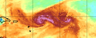
This is an image from the Mimic Loop.
Precipitable Water Vapor. Moisture.
Below is the NHC Visible Sat Image


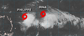
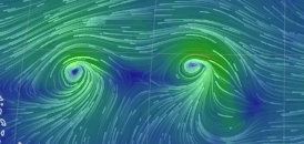
They look separated here, moving apart.
But above you see the real story.
While they each have a center...
...it's a murky singularity at best.
Yes meant singularity not signature.

Kind of like siamese twins.
Joined together in ways.
Usually if separated they do better.
Depends on the specifics.
Details are important in meteorology.

Easy to make this a tropical love story.
It's not.
One is actually killing the other.
One is a parasite in ways.... 
...trying to attach to the host.
Sucking it dry.


If this was a novel I was reading I would have already passed it along to a friend who might enjoy it more than me or donated it to a Neighborhood Library Box. Maybe someone else will enjoy the "dance" between the two but these feel like leftover defrosted fish sticks that have a bit of freezer burn on them, never the less, regardless .....they will go somewhere but until they break up it's hard to even watch loops. I lost interest a long time ago and the plot is all over the place, we need a good script editor as the screen writer fell in love with his own characters a bit too much. It's not impossible one survives and is far enough West to pay close attention be it the Islands or Bahamas but until that actually happens all bets are off. As always check with NHC site and your local experts online.


From left to right there is a surge of tropical moisture (deep reds and ochres near the Yucatan that is being drawn up along the SE coast over Florida. That area is connecting with the remnants of Ophelia because it's 2023 and tropical storms don't know how to just die. There is ongoing flooding in NYC and areas along the coast of NY/NJ and all those places where people are either Jets or Giants fans as New Jersey doesn't have a football team. In the center at the top of the page is dark, violet blues pushing DOWN into the Atlantic onto that strand of topaz, coral shades of golden orange with a strip of moisture strung out right now. Then we have the huge tropical wave complex known as Tropical Storm Philippe and Rina. Further East to the right we have nothing going on really.

Where do these storms go and will they go their separate ways? 

In theory, as even the NHC has made it clear they are not sure, Rina may move up around Philippe sort of drawn up to that orange area that seems to want to go NW like every other storm in this family group. 


Discussion above.
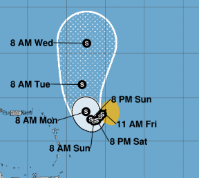
Philippe is not forecast to be a hurricane.
Philippe will "crawl" along (NHC word)
Moving SW slowly...then it finds a way North.


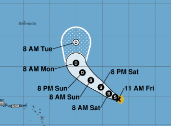
Rina moves a bit faster than Philippe
I really don't know why they upgraded to Rina.
I suppose their forecasts now verify.


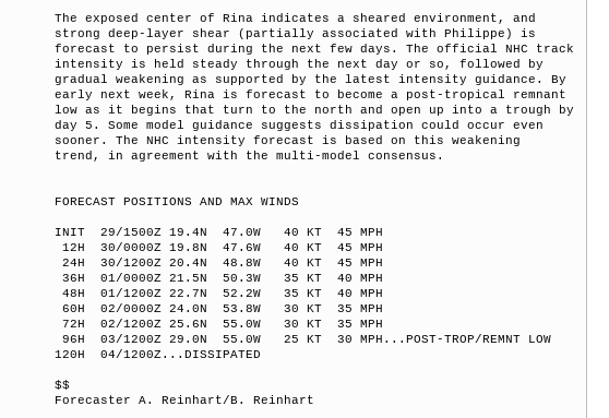
NHC discussion is a sad story....
...of lost opportunities.
Exposed center.
Dissipation....
Stays weak tropical storm....
...and then dies.

What do I think? I think this is a storyline that should be watched over time to see what really happens. I find Philippe's track strange but it's been a strange year, it moves slow so while moving slow ...oh wait "crawling" things can change. Rina I think was a flawed system more a tropical depression a Tropical Storm with areas of strong gusts above Tropical Storm force and they went with upgrading it. My opinion, as in the old days...not that long ago, a Tropical Depression wasn't upgraded because somewhere in the messy complex there were gusts over Tropical Storm force, a system .. a tropical depression had to really prove itself to be upgraded to a Tropical Storm. Names were not given out for participation then you really had to meet certain criteria. 


I'm not arguing the "closed center" question.
Exposed or otherwise.
Enjoy it if you want ....I have things to do this weekend.
I'll be offline until Sunday evening or Monday morning.
Sure Philippe and Rina can spin without me.

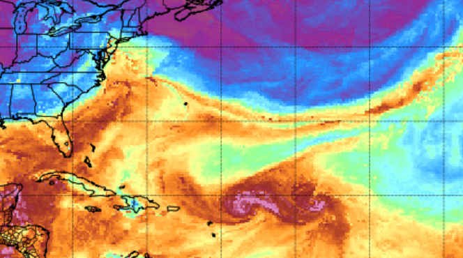
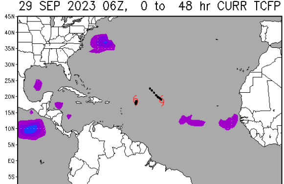
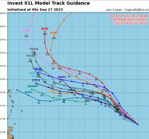
Looking around the tropical basin.


That's a lot of rain in other places.
2 areas in the Gulf of Mexico ...
...frontal boundry, moisture surge off E Coast.
Note rain connects with the purple blobs below.


This NOAA map for the next 48 hours...
...shows an area off E Coast.
Areas in GOM and Carib.
I'd watch those areas.
At some point...
...in October.
Something forms somewhere.
October is tomorrow ...
Let's say first week of October.


Because the flow is fast....
...nothing is forming.
If the flow slows down.
Bears watching.

Big story is the remnants of Ophelia.
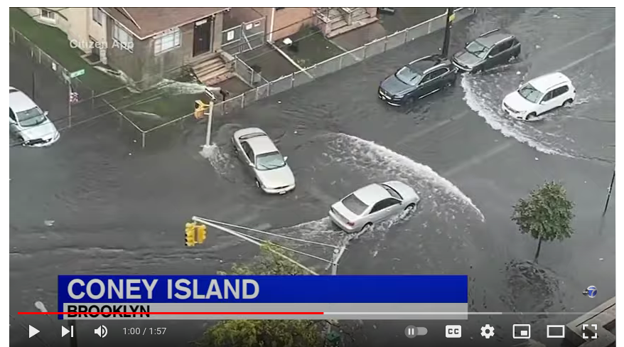

That's Brooklyn.
There's worse flooding but cool pick.
Annoyed the way this is being handled.
People ignore NWS info and go to work.
No watches/warnings. No name.
What's the big deal?
You'd think after Ida remnants they'd get it.


Take this seriously in NY/NJ
Very seriously and be careful.
Stay aware of flooding.
Flash flooding.


Sweet Tropical Dreams
or Winter Dreams.
Seems it's Autumn.
Enjoy it if you got it.

BobbiStorm
@bobbistorm on Twitter and Instagram


Thursday, September 28, 2023

Updated Noon Rina Forms! Troubled Forecast for Philippe. Reset the Models. Let's Start Over ... I Want a Do Over. Philippe Hanging on to Ball & Chain 91L (Rina) Caribbean Convection Moisture Train and Miami Rain.


Rina Cone.
Slow movement for days.
Then takes off for NW turning Right.
First cone.... can change.

11 AM Cone for Philippe


Smaller cone.
Wide meaning high uncertainty.
Models below.


Models for Rina below


Bottom line at midday... let's wait and see how both systems do and wait on more model runs and know they are there and Hurricane Season is not over. 

Sorry I didn't update earlier but I have a brother who had a sudden health question so they are doing tests, kind of like waiting for next model runs... so hopefully he's okay just needs some meds.

Not sure meds will help Phillippe or Rina... more a matter of time, they need time to move further apart and in time we should know and I'm not writing an essay on time.. Nuff Said.  Will update if anything changes from NHC. My thoughts below are the same, nothing really changed except Rina did form (finally) and models just flipped and I'm getting a cold front next week ... unless models flip again. 

* * * 

10: 30 AM


Leading with this graphic above.
Just about says it all.
Not sure I ever saw one like this...
... thought it was a graph of the Dow!

Intensity models do not agree.
Using this graphic as it is easy.
I'm a writer not an artist.


Mike is in Talledega ..
...go Mike and family!


Invest 91 not yet Rina.
NHC said maybe today...
or tomorrow. 


We have the huge complex known as Philippe and what wants to be Rina in the Atlantic so close it's hard to see where one begins and the other one ends. 91L (Rina) looks like it's part of Philippe's outer banding. A huge frontal boundary complex goes from the EPAC up through the Carib into the GOM into off the coast of Carolinas (some remnants there from you know what) and out to Europe.  Possibilities of something off the coast of Carolinas and something down in the Caribbean has dreams of getting a name and a measure of fame. 

Note Philippe is barely making any headway and how could it as it's being dragged down by 91L like a ball and chain and they just ooze about transfering energy back and forth from one to the other though for now Philippe is winning despite attempts by NHC to write it off. 

So we are going to give it some time and I will update this blog later today.

Problem really is models cannot properly handle both systems at the same time properly, especially at this time of year when we are done with summer but not yet ready for winter and even the forecasts for the current Fall period are conflicting. Either we are getting a kick ass cold front in a week or so or it's just gonna be mild with a chance of CAD (cold air damming) in the Carolinas. Sunny and so pretty today I feel this crazy urge to take the garbage out just to take some pics of the sunny skies as yesterday it was gray like Seattle, but not as pretty or bright as Seattle gets when it's a shade of gray that is really more white than dark as the pit from pole to pole.


90% chances of formation.
Philippe still cfrazy after all these years.
(it just feels like years)

The reason for discussion at the top.
And the Cone at the bottom.
Was to explain the Cone.
Shown below...
The real truth is....
They don't know...


Again let's look at those models.


Bottom Line:

It's going to wander along to the West for now, possibly dragging what will be Rina with it or with Rina pivoting around it leaving it in the tropical dust. Or they are going to fuse together into a power incredible to behold. Or one wins out and the other dies or wanders along trying to find traction somewhere else.

They don't know.

Truth is for a while it'll go West as it's a weak mess (it's meaning the whole messy complex there) and at some point (should it survive) it'll pull North towards the Poles anyway it can when it can as that's what tropical systems are progammed to do. Perhaps we need to hit the reset button. Meanwhile something may brew up from the Caribbean but not yet as we move into the first week of October we will watch more carefully. It's going to rain, rain, rain, rain in South Florida somewhere for the next few days from the stalled out boundary, tropical moisture all colliding as it's just that time of year.


Next 5 days rainfall forecast.

Sweet tropical dreams,
BobbiStorm
@bobbistorm on Twitter and Instagram

Until Philippe breaks up with 91L
(and vice versa)
They are stuck dreaming... 
Action is needed here.... 
...which one blinks??


Okay that's an oldie goldie from when Hurricanes were female!

Let's go older.... 


If you live in Miami....
...it's all about the rain.
Just rain.
Not tropical rain.
All the same though


(you thought I was gonna play Alanis ??)
(always been an 80s girl)

I was gonna explain the Billy Rose song
But that's a sad story.
He lived in the shadow of his wife's Ex.
No one wants sad today.
Not me.

I'll update if there is something ...
...definitive to say.
Haha no not that jingle either.

still here?
...go get out enjoy the weather.
Winter is coming.
Also maybe Rina and Tammy and 
oh my goodness Whitney for Halloween?
Vince
BOO!!
I see both of you :)


Wednesday, September 27, 2023

Philippe Fighting with 91L Over What's Left of the Energy in the MDR (Kind of Ugly Battle) Does Rina Form? Carib in October Usually Hot. Thoughts on Tale of 2 Seasona and El Nino


Philippe is still alive.
And, now gets into the Islands...
...as a TD maybe.
A lot of maybe there.
Weak goes West.
May work in it's favor.


Rina has not developed yet.
But it's forever 90% it seems.


That's Rina above if and when it forms.
Hate to see NHC have to walk that back...
...long walk from 90%!


Note some tracks are tracking West.
Others try to make a break for the NATL

Time will tell.
The ending isn't written yet.
Tho someone etched it in on their note cards.

This Hurricane Season so far has been a tale of 2 seasons. 
The HOT MDR where weak storms formed until they got to NATL and got strong. Didn't want to go.


Will anyone but Phil Klotzbach remember them??


And Mets want to argue El Nino isn't a thing.
Yeah, right. Sure...
Shut down the Carib and GOM fairly well.
!!!

Our first GOM system went backwards from almost N FL to Cuba before NHC pulled the plug.
Idalia, people will remember, seeded from the EPAC which is fine...as they owed us.
A strong wave that could never get going ....got going in EPAC and traveled most of the Pacific.

So you can all talk about how El Nino didn't really impact 2023 because... MDR blah blah blah hot water and we are running out of names blah blah blah ............. again I don't chase nor track ACE.

So what happens in the Carib as we move towards October as our attention does move there usually in most seasons. And, anything that forms down below must be watched up above, especially in Florida. 

Philippe might limp into Carib region on gas fumes depending on what happens with Invest 91L that was set to be Rina but it won't let go and it's zapping energy from Philippe and then Philippe zaps it back from 91L ...gotta tell you that's leaving a bad taste in my mouth personally. We saw this often in the beginning of the season when those wild waves over the very hot water kept pulling energy from each other and here we are again on September 27th with not much to write about....

Expectations in October for numerous reasons but easily speaking there's a huge moisture surge, lowered pressures and dangling fronts and some westbound tropical systems falling apart will all collide down the tropical road and then we will see what will happen. Because El Nino it's more logical to think something forms closer to Cuba/PR ... Florida Straits gets into Gulf of Mexico maybe and then develops where it's more friendly or we have another Nicole like system (that was fun have to say, wild sea foam maker) or another Close In ....Home Grown ...Surprise System. And, for all the HOT WATER in the MDR there were very few long tracking African Waves that made it even to 75 West... so yeah we are waiting to see what happens in a week to ten days (or less if there's a "surprise" pop up system.

Have a wonderful day. Hope you're getting the type of weather you want and if not I hope you have the time and money to go somewhere it is!

My daughter who is Copenhagen today (Sweden yesterday) says YOLO!! 

Besos (Means Kisses by the way ...that's what we say in Miami)
BobbiStorm
@bobbistorm on Twitter and Instagram
I'd say Sweet Tropical Dreams but currently I'm in a F Scott Fitzgerald or Zelda mood and more into Winter Dreams.

Ps I watched TWC today and all I want to know is why is the young guy screaming the forecast as if he's at a State Fair trying to sell Cotton Candy ...does he think only old ppl watch TWC they have hearing aids and are on River Cruises talking to their friends from highschool on their cell phones. Stop screaming... and someone explain to Abrams that FLL wouldn't have so much rain if not for that one event that lasted about 7 hours and gave them more rain out of nowhere ...the rain bomb that hit Port Everglades and FLL airport otherwise they'd be in a bad drought too ...because we get rain from tropical waves, tropical depressions, tropical storms and they all turned RIGHT and went North. But I digress. Cantore, as always, is golden.... he's a National Treasure more people should learn to show the weather the way he does ...like Paul Goodloe who is always Good too!

Yes in a mood.


Ps cute fun song
But Havana Oooh Na Nah is sexier.


Tuesday, September 26, 2023

Your Tuesday is My Monday... A Look at the Tropics. Currently Sleepy, Boring and Snoozy VS Newsy. Meh Systems Today.. Down the Road Definite Maybes and Carib Blob


I really should have started with the Carib Blob but it's only a blob right? Well, yes but it's slamming our friends in the Caribbean with flooding rains creating some misery down that way and it's definitely Blobby Weather Drama with it so it's worth mentioning off the bat. Kind of cool feature, has curvature and if you are desperate the look of banding. It's purple blobby on the map that I show when there is no yellow lemon, which is good because seriously I'd prefer grapes or blackberries to lemons, wouldn't you?


NHC main page below.
They did go long on discussion rain down there.
Caribbean Tropical Wave
 Convection... etc. 

I call that weather.

As for the official NHC News


2 PM
90% on Rina forming close to Philippe.

Y'all have to excuse me because my Tuesday is kind of like your Monday making this a short week for me. I was offline yesterday for Yom Kippur (which is kind of an intense holiday) and the day before helping get ready for it and doing things related to it and now I'm in recovery mode as it feels as if I've been offline for 3 days, not just one. For those of you who have followed me over the years you know I get quiet during the holidays for me often ....well unless there's something big going on. There is nothing big going on in the tropics today. Two systems forecast to be rinse and repeat recurvatures with always the slight possibility that one escapes from the pack and makes a run for the Islands or the SE Coast. Nothing shows up coming from the Caribbean Blob but we do see something forming again close in similar to Ophelia and that could come from the general surge of energy coming up from the Carib down the road, especially if a weak front makes it down towards Florida and goes flat as they often do the last days of September and into early October. 


Water vapor shows the surge below.


It's a pulsation of moisture.. surging.
And it's not going away so fast.
So stay tuned.


As for Philippe and Rina... (in the wings at 90%)

As for the models we are starting with the CMC because it has been kicked around often and yet has often out performed the Euro and GFS, tho maybe not the Icon. On any given day a model latches on to something, it's your job to figure out what that is and what the end game is when something develops somewhere .... it's generally not exactly what you think but it's showing something between the highs and lows and isobars in between.

Another Carolina Blob/Low on last day.


Hmnn

Rina Philippe drama. Loop below.

https://moe.met.fsu.edu/cgi-bin/cmctc2.cgi?time=2023092600&field=Sea+Level+Pressure&hour=Animation

There's only so much tropical energy and neither systems look fantastic out of the gate. One will outshine the other, one may get further West as it's pushed around by the other and then they both end up in you know where ....with the new system that forms out of nowhere or possibly somewhere that no one was looking as everyone was distracted by Rina and Phillipe. If Rina gets named and it should as they are already at 90% Red.


Euro shows Rina outshining Philippe.
Oh could that allow Philippe to come back...
...closer in? Hmnn

As for the GFS below.
Best not to drink coffee and run the GFS.


 GFS...stopping the loop here.
Just off OBX something pops up.
Remember that.
Weak Philippe... Hungry Rina


Then there's 2...or 3
Weak P STRONG Rina
I know none of us trust it...
...but we all have to watch.


I'm just gonna go with... what the hell?
It's a Picasso psychology test... 
..where is your mind?
Ya... GFS likes Rina.


Icon above shows weak Philippe IN the Islands.
Or just to the N and Rina strong.

That's about it for me today. Rina looks to be a player, I have a friend named Rina my money is on that one! Philippe (2 Ps 1 L) could be a player depending on how valid these models are and if they verify.  We have nice pleasant weather in the Carolinas, not too hot, not too cold. Cannot wait for it to be "too cold" but time will tell on that as we are at that part of the Hurricane Season where it looks fairly dead but it's probably just playing Possum as October almost always produces something huge, threatening and hope the chasers such as Josh (iCyclone) have something meaty like good steak to chase because not much into Impossible Burgers even if I can put cheese on them making "kosher cheeseburgers" but I'd rather use real meat and fake cheese for that. I'm not very into fake if you have noticed, tho I can appreciate weather even if it is a weak Tropical Storm rocking my world in Raleigh as few get far enough West to have Tropical Storm Force gusts and we did in my part of Raleigh ...one of those big cities that stretches out into various directions and as it's hilly here depending on what street you live you might get an inch more rain than a friend not so far away and stronger winds or no wind. I got wind, I got rain and I'm happy. Hoping for more but it was a tropical smile in my book as I dream on snow and possibly a storm a storm at the beach.

I'll update tomorrow on the ongoing Tropical Soap Opear of the GFS and in reality talking on what is happening in real time as that Caribbean Surge IS producing WEATHER and that's what it's all about in my book.  Being in the eye of a hurricane is awesome, hard to even explain and I'll just say it's one of nature's true wonders that all the violent, wild winds suddenly stop and you can hear a bird suddenly chirping in the quiet while you wait for the wicked, back side of the storm to suddenly appear and I do mean suddenly. If you're lucky it's a long eye in a slow moving storm so you can really enjoy it!

Sweet Tropical Dreams,
BobbiStorm
@bobbistorm on Twitter and Instagram
Ps I truy, madly, deeply love weather :) 


Saturday, September 23, 2023

Ophelia...A Beautiful Stormy Saturday Morning in Raleigh. Torrential Tropical Rain, Gusty Winds. Delicious. Memories & Thoughts...


Image from Zoom Earth.

My official post online.
Below are my longer thoughts.
I pay to edit and go long when I want.
I wanted to.....  
.... was a wild, strong but mild Tropical Storm.
Delievered strong gusts 39 MPH by me.
Very gusty for a while.
Can't beat sitting on your balcony...
..with coffee and honey cake watching it all.

Something wonderful about tropical rain meeting cool fresh air. Tropical but also Wintry a taste of what may come down the road. Figured would come in near Jax Bch/Emerald Isle & be near New Bern work it's way up near Tarboro somewhere in there ... Richmond had strong Wind Probs consistently seemed logical would track closer to Euro's more W route and then going up I95 on it's way somewhere else. Just a fun day chillin, smiling enjoying the beauty of real weather. For a few hours the rain made quite the racket coming down hard like it was raining bullets (u don't get that here w/o tropical wxr) steady, heavy a fantastic way to start Fall in this part of NC & back side as it pulled by blasted the area with cold wind out of the North. Real Equiniox Storm!


I've been here on the beach in a Tropical Storm & while "fun" it's not very tropical lol no coconut palms swaying in the same direction as in Miami or the Keys. Strong enough to take the power out across the state in places mostly to the E but moved West enough for part of the rain shield to get to Pittsboro & beyond and Martinsville. A "friendly" storm & it has places to go up the coast. For me was nice to be home, watching what it did to my neighborhood, staying in bed, taking a walk around taking it all in and enjoying the cold air it delivered too!

Ironically getting wind reports as strong as Idalia that underachieved on the wind reports vs storm surge. One thing I like about NC u get the chance for tropical weather & snow... Not a Hurricane but a gusty strong Tropical Storm out performing her original forecast. Next... where's the real stuff but very grateful for Ophelia! I'll remember her well

Not a Hurricane memory, but a nice tropical stormy memory!


Some tree somewhere always falls.
All in all little damage.
Well unless the tree fell on your home.
Sorry.
Flooding in Greenville and New Bern.
Love New Bern, had I gone anywhere...
...would have gone there.
But home on my Sabbath and was awesome!


Landfall 

As I was offline I'm going back in time and reliving it again online. Awesome storm especially as it ushered in Fall, chilly pajama weather ... lying under covers next to the big huge window staring up at Pines that rarely have dance moves like that... wondering the whole time what will winter bring to Raleigh. 


The lead Mid Level System.
Crazy Waves and high surf.
Flooding up the coast...
while the center is being tracked.


This was my bottom line Friday
In the blog.
EURO was clearly on the inland action.
This was the last EURO I saw.
This is exactly the radar we had here...
...image below from Friday's blog. 
Center to our East... then NE
A crazy heavy band of rain over us.
Then went so far inland it was over...
Pittsboro at one point West of us.


I understand how the NHC makes it's Cone, most of us do, and you're covering your bets with the furtherest good model East and the Western one... cone wider or more narrow depending on how far apart the models are and yet sometimes you gotta make a call. I was going to go with the EURO on this one and again it was obvious it was going to be WEST of the Outer Banks ... Emerald Isle is officially South Outer Banks... South and West and with that movement to the NNW and then N this was not an OBX storm even though they get the surf always as it juts out so far into the ocean. 

Will start fresh in the morning with Phillipe that sits out there looking to be another recurving storm but will it. Hearing rumblings and grumblings about it. I'll deal with that tomorrow.

I'm happy.
Had a fun day wearing my Winter Victoria's Secrets PJs sipping tea, under a cover looking out the window that was open a bit... fresh air and gusty wind and torrential tropical rain just smiling, loving it all. I'll remember Ophelia fondly. But her Mid Level area ContentWxr is tracking is kicking up surf, causing coastal flooding far from the incpient center NHC is tracking near the VA/NC line. 


Again I was here in the Western part of Ophelia


Ophelia proper indeed!

Stay tuned.
It'll be downgraded.
But it won't be over 
Tomorrow will be messy up that way
And chilly, cold and Fall is in sway

Besos Bobbistorm
@bobbistorm on Twitter and Instagram

Old song
Was looking for something about Saturday Morning.
Woke up just after dawn... opened the windows
Lay covered, cuddled in bed
Staring at the wind and the trees dancing
Husband slept and I just stared, smiling.
It was a good morning.
Just got better and better :)
Yay Ophelia.
Tomorrow will be a messy day...
..up the coast.


I heard TD 17 got named.