A writer and a tropical muse. A funky Lubavitcher who enjoys watching the weather, hurricanes, listening to music while enjoying life with a sense of humor and trying to make sense of it all!
Friday, June 30, 2023
No Hurricanes July 4th Weekend in ATL Basin. EPAC Busy. Quiet in the Tropics. Watch Out for Heat & Smoke From Canadian Fires
Heat Alerts. Smoke From Canada ... Poor Air Quality Alerts. Tropics in ATL Fairly Quiet. EPAC Lit For a Change. Stay Hydrated!!
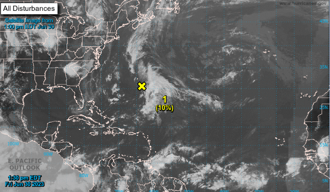
Down to 1.
Northbound IF anything forms.
20% in 7 days.
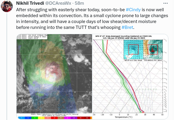
X Cindy has gone away....
...not coming back for another day.
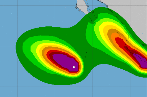
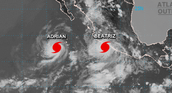
EPAC has Adrian.
And B storm should form any day...
(not headed for land...so moving on for now.
Let's talk about the HEAT in Miami.
No not the basketball HEAT
The REAL HEAT
Note from image below...
...afternoon tstorms on vacation.
Moved up towards N FL
Some clouds but the storms aren't storming.
When you don't get Tstorms at 3 PM
It gets really, really hot.
Dangeously hot!
I have a nephew who had a strange infection, was sore, feverish and he went to ER and they treated him but.... number one thing on the list for cause was "dehydration" and my daughter's friend's boyfriend passed out at home, came to groggy and bleeding (Broke his jaw when he fell, it's wired together now.......) he went to ER and after operating and treating him and being tested for Lord only knows what they said he passed out from dehyration (apparrently just after walking in the house) and yes that happened.
Another friend said his wife while gardening keeps getting dizzy but it's okay she's misting herself, no really it's not okay. Miami people aren't really used to this heat because this time of year it rains in the afternoon at some point and the temperatures break some and while it's muggy awful the temperatures come down. Drink water, pour the water over you and then go ahead and mist if you want.
It's 86 degrees at my house.
In Raleigh, where I live when not in Miami, is under a Health Alert as smoke from the fires from Canada are swiling aound down this way and that and the high temperatures are creating havoc for people with asthma and other breathing problems. Yes, I am indoors. As a matter of fact, I'm not even cooking. My husband is bringing food home from the Kosher Food Truck that is usually at Duke University but since they are on summer break........we get a break and having Shwarma for dinner. I made a salad. By the way it's Kosher and Halal certified!!
High Heat. Dry Heat.
Smoke from Fires.
Why anyone likes summer is beyond me.
Had all the summer I needed growing up in Miami.
As for the Tropics....
We have a pattern going.
Currently everything hangs a right before the Islands.
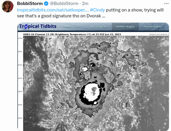
Is Cindy Alive or Just a Ghost? Remnants of Cindy Try to Visit the Site of the Titanic in the NATL.... Strange Plot Twist!
Yellow X
like a submersible...
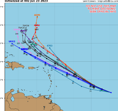
30% in the 7 day....
Will update later after next model runs.
And some better visual imagery.
And a good long hot shower.
Good shower :)
I'm back.
Shower and Nespresso always works.
Ex Cindy could use some Nespresso!
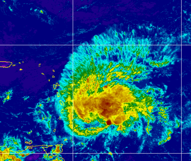
A look around the Tropics shows us the "remnants" of Cindy flashing colors in the Atlantic way East of Florida, it's worth remembering whatever remnant circulation there is left there is far to the West of the colorful convection. Ghost of Cindy is being sheared tremendously currently, however some models show that the shear relaxes and Cindy grabs her clothes and begins to spin a bit ...possibly zooming up to North Atlantic seriously near where the Titan and Titanic were lost. Oddly sometimes when an area is "hot" news wise it stays hot news wise so we are watching Cindy's Ghost!
Down in the SW Carib the reddish golds are remnants of Bret and they are I may say stronger in intensity than anything Cindy has going on or blowing away in the shear zone.
Approaching the Islands is a tropical wave not getting much love or attention from the NHC. Probably because the negative conditions that ripped at Bret would do the same here, but it's there do not forget.
Note the ITCZ behind the wave is suppressed from SAL, High Pressure and it's not a friendly piace right now. As a matter of fact looking at MIMIC we can see how thin the ITCZ is compared to a few weeks ago when it was one solid thick band of color.
That's a dramatic change in the ITCZ.
Note "Cindy" is tapping in to the tropical wave...
..Mimic shows her gas line..the moisture feed.
Also note "Bret" still moist there.
Will what's left of Bret get into the EPAC?
Will that DNA help spark a storm there?
Time will tell.
Just being honest.
Tropics are quiet.
El Nino in sway.
How strong it becomes....
...anyone's guess or forecast.
Cooler waters near Africa than before.
Stronger pulse of El Nino moving West.
Cool waters around Florida/GA oddly.
Odd times....
...waiting to see what we see.
For now it all comes down to Ex Cindy
30% chance in 7 days.
Stay tuned.
Sweet Tropical Dreams,
BobbiStorm
@bobbistorm on Twitter and Instagram.
Twitter mostly weather .. Instagram whatever.
Ps Stay hydrated if you're getting the heat today!
Bret Dead. Cindy Dying. Will Either Come Back to Life? Tropics on Hiatus Today ... What Next? Whatcha Watching Today in the News? Asteroid? Titan/Titanic?? Russia Russia Russia???
The best way I can say this is to show this tee shirt image you can buy from Mike's Weather Page in a variety of colors. Currently we are watching blobs and when I say that some have had a name and still have a name, but nothing impressive is out there today or tomorrow.
There's waves out in the Atlantic but none of them are strong enough to get the attention from the NHC and there is some fluff and stuff off the coast in climatologically favored places but nothing is forecast to spin up into a homegrown mess anytime soon. Some models are still playing with Bret but it's most likely that parts of Bret's DNA gets into the EPAC that despite having orange and cherry circles has had problems getting a named storm spinning. There's some vorticity involved still in what's left of Bret that actually in some ways looks better than Cindy.
Cindy, Cindy, Cindy... where do we start with Cindy? There is a slight chance that after Cindy falls apart it's remnants will be stuck by tropical lightning resuscitating a storm that barely was and it races off to the wrecks of the Titanic and Titan to cause more high seas there and they have had their share of high seas. That's not much to talk about here. Until it passes Bermuda, sure keep watching it if you have interests in Bermuda but for now it's not looking impressive.
El Nino is a thing, you can try and deny it but you will see the bigger picture soon and the two early storms that were impressive for June could not get going or really gain traction because of an abundance of Saharan Dust (see incredible pics of sunrise in Miami every day online... you don't get that much color without some SAL there in June) and shear that's usually there but enhanced by the building El Nino and despite warm waters by the Main Development Region that doesn't mean those well developed waves supported by warmer than normal waters can get a hurricane going that's going to go the distance just yet.
I'm not pulling the plug on the 2023 Hurricane Season by any means, I'm just saying we are on a hiatus of sorts until something presents itself to write about other than "blobs" we can watch.
Do I think it's totally over for Cindy? I've always had a problem bonding with Cindy and so far it's not calling my name to pay close attention. I think it's oddly interesting that in a karmic way it wants to go to the one spot in the hurricane map that has already had attention this week as the graveyard of anything with the name Titan in it. Think about it.
Otherwise people are watching the Asteroid about to slide between Earth and the Moon (hopefully that goes well) or watching the odd story that happened over the weekend in Russia that played out like the Mouse that Roared (old movie) because now if he survives to tell about the man who ran the real army fighting in Ukraine can go back to wherever he wants to go free of Putin's needs and well it's complicated but my degree in Geopolitics with specialty in Russian Studies is way more interested in this than Cindy tho Bret still gets a bit of my attention.
Oh and it's Summer today and I feel the need to play and enjoy "summer" even though it's not my favorite season. I see Ice Cream in my future today!! Maybe the beach, maybe the Lake, maybe the Flea Market or who knows... summer doesn't have to have a To Do List does it.?
Check back tomorrow and we will see what Cindy did and if Bret's left over DNA can show up as a distant cousin to a new system somewhere and if the asteroid flew by as forecast.
Update 8 PM Saga of Bret & Cindy - Never Stop Watching Waves.... 2023 Hurricane Season
Both storms were 50 MPH today.
Bret not falling apart yet but forecast to.
Cindy forecast to be a player if it survives.
So many Ifs... because it's June.
cindy trying...
Will be back Saturday evening...
we'll see what we see!
Have a good weekend!
Bret found interesting ways to survive last night.
First it did this...
2 red dot like eyes.
Half a rain shield.
Then........it did this.
I didn't fall asleep.......
A ball of convection jumped out towards the center.
Bret moved faster (played leapfrog)
You can see the shear is near the center.
Naked exposed center doing fan dances...
The oddness of Bret is that it has always done something to stay aive. Nothing lives forever... but once all shriveled up and looking shrimpy it grapped onto moisture behind it from the wave that was huge, large, wet and moist and pulled that moisture in as if it found a gas station in the desert and took as much gas as it could get. And, Bret rebuilt and continued West. Wave behind it looked paltry, messy and then it slowly rebuilt a small shadow of it's huge girth and became Cindy. Now we have two who refuse to accept the date on the calendar.
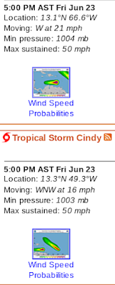
2 Tropical Storms.
My favorite graphic of the day.
Bret on the left.
Cindy on the right.
Wind Probs Map.
Bret has 60 MPH winds and BM 1001
Cindy has 45 MPH winds and BM 1005
Models
Being honest, models show Bret moving Westbound it's remnants fanning out to the WNW and other models show it trying to stay alive long enough to get into the Pacific. NHC has Bret unraveling finally in the Caribbean a victim of shear.........dry air... El Nino blowing hard. I'm just gonna watch the Bret Staying Alive Show until it's all over. As for Cindy I don't want to show models as I really am not sure they are reading it well as it's a very small storm and I'll wait a run or two to see what I believe. It's forecast to move WNW more NW up into the ocean... as was Bret but with Cindy we can see what's trying to grab it.
I'll proof this later and adding a song now.
They may be small but they exist.
For June "too soon" that's impressive.
Rare year with low shear, low dust and warm water.
TD 4 Becomes TS Cindy (say it like Sin-dee) NHC Now Tracking 2 Tropical Storms in June That Cruised Thru MDR. Now What??
And then there were 2... in June 2023
Tonight's discussion keeps it a Tropical Storm ...
....bit too soon for me to believe anything.
But it's got a lot of struggling to do in a dry environment.
Shear... time will tell.
There are things we see and things we hear about upgrades and it was fairly obvious that TD 4 is getting an upgrade to Cindy at 11. A simple trip to any site will show you the satellite names have already been changed.
Went to check it out on satellite imagery.
Things like this ripple across Twitter.
Tho it's always been that way..
Also an ASCAT managed to find TD4 aka Cindy
Note it couldn't find Bret ... missed it twice.
NHC discussion mentions the ASCAT pass..
Most recent models.
As for Bret it's currently IN the Islands.
Still Westbound at 18 MPH
60 MPH
As the sun went down.... there the were.
Cindy smaller than Bret
But making records.
Stay tuned.
Make a plan for Hurricane Season.
It's been a bit funky.
Who knows what happens next.
Sweet Tropical Dreams,
BobbiStorm
@bobbistorm on Twitter and Instagram
Twitter mostly weather..Instagram wxr and whatever ;)
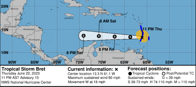
5PM Update..... Bret Now 65 MPH .. TD 4 Foms 2023 Tracking 2 Systems in Late June. Hurricane Prep Should Be Where You Are At.
65 MPH W at 16 MPH.
Center is the bottom blue clear dot...
left of the red blob of energy.
Ps it's not just shear.
There's dry air there seen below
Orange dots ...dry air.. SAL
Typical enemies of June tropical waves and storms.
Keep this in mind....
Always at the top of the cone site at NHC...
"Note: The cone contains the probable path of the storm center but does not show the size of the storm. Hazardous conditions can occur outside of the cone."
Bret 2023 looking a lot like Bret 2017
Further N and went further...
Bret 2017. Climo Wins Often...
...can it survive? Stay tuned... Models below.
TD 4
Stay tuned.........
You can see track for TD4 bit too soon to be set in stone!
Bret is a complicated storm, a complicate messy storm according to many but to me it's a fighter, fighting off shear and traveling through waters that few June Tropical Waves dare to even try. At times it tries to intensify and become a hurricane, at other times it's a tilted system (because of shear) trying to move west continuously despite less than stellar conditions to exist let alone even try and be a hurricane. This storm just doesn't want to give up. And, yet all storms meet their end eventually either raining themselves out far from landfall as Ida did in NY and NY or they unravel and fall apart due to shear and a lack of positive conditions in the Caribbean in June. Sometimes they end up staying together just enought to flare up later crawling towards Central America, once in a blue moon making it into the Pacific and once in a very rare blue moon they reform and try once again to stay alive. The ending is written in pencil right now, it's far from over but the odds are against it. That said...the odds have always been against it lol... seriously.
New kid on block TD 4 has higher latitudinal aspirations and models show it pulling NW making people from Florida to the Carolinas watch it more carefully, though Bermuda probably really needs to pay attention and well anywhere else in that direction keep watching should it intensify and develop differently from Bret that's doing a remake currently of Bret from 2017 and let's all pray 2023 is not a remake of 2017 in the tropics!
Allan Huffman is one of my weather favs in NC.
As mentioned on air today we are watching TD4.
He covers everything above.
He's very good.
Good to follow!
For Tropical Wxr or Snow!
So going to come back later today and see if Bret has peaked or tried once again to "come back" and how the models are handling TD 4 and never stop watching waves because the one behind TD4 should be an Invest sooner or later.
4 things to note here.
Far to the West is a vertical line... strong shear there.
Ever have a younger sister and in some corner of the image is this little head at an odd angle smiling trying to get in the group shot? That would be TD4 there, newly named, but let's stay with Bret this morning. Keeping this short and I'll update later as we see what NHC does at 11PM and wondering when the NHC will add the 3rd wave to the mix on the main page as it's obviously not fading away once off the coast of Africa.
June 22, 2023
Trying to channel up August...
Going with this image from Zoom Earth.
Check them out...
2 storms.
2 tracks.
1 goes W
1 goes NW.
Truth is I was a bit annoyed last night because it was obvious that Bret was intensifying and all I heard online was everyone trying to explain how you could see it was "falling apart from shear" when it fact it ws intensifying. You can't really judge a June TS in the deep tropics comparing it to an August/September TS in the same spot. It's like a little girl dressed up all cute in heels wearing make up ...she's adorable but not ready to compete as Miss America ya know. Into comparisons today.
Last night Bret was intensifying.
Why it was missed I don't know.
I know the excuses but still surprised me.
Problem with how many in the media and many mets have is how they sometimes fail to properly convey to the public the possibilities that could happen. Many are so tied to the previous forecast or their favorite model output, it becomes too Academic to many and as I worked in Academia running a library I learned way too much about Academia both good and bad.
A hurricane and sometimes even more a June Tropical Storm is the sum total of everything inside it whether it's perfectly formed or not. More so with a Tropical Storm that often has competing vortexes and wild flare ups of Thunderstorm with winds to Hurricane Force not perfectly aligned over the center. Tell that to the person whose windows blow out because they didn't think they needed to prepare that it was just some mini vortex not really the center of the storm. On the ground the impacts are differnet on every street, every island depending on random weather inside the named storm moving West or just N of West and it's not very academic when the tree in your front yard falls in a stronger gust than you thought you'd get and part of the ficus tree is blocking your front door.
So that said........no matter where that flare up was noticeable and sustained for some time in Bret it was obviously banging on 70 MPH winds door and to write it off and put out an advisory that just kind of extrapolates the previous one without pointng to areas within the strong Tropical Storm could have a strong punch depending on what cycle it's going through as it comes through the Islands. And, sometimes when shear is shoving, rearranging and trying to tear apart a TS trying to be a Hurricane entering the Caribbean someone in the Islands gets a crazy intense part of the storm while others just get some healthy rain
Whacky things happen in situations like this and it's best to err on the side of caution and not be so locked into an original forecast by leaving the door open for stronger weather, and to be fair the NHC did put up a Hurricane Watch currently for the Islands.
We will discuss the models later.
And TD 4 later.
Stay tuned...
I'll add a song when I finish later..
Waiting on 11 AM Advisory....
Sweet Tropical Dreams,
BobbiStorm
@bobbistorm on Twitter and Instagram
Twitter mostly weather and Instagram weather and whatever...
From Publix site........
...good checklist!
https://www.publix.com/pages/publix-storm-basics Figure it out now because one way or the other there will be many more dangerous threats than Bret... 2023 will stay busy for a while even with El Nino trying to shut down the latter part of the season. Prepare, make a list, do what you have to do if you live in Hurricane Country. If you lived in Buffalo and were new to the area tell old timers "I'm sure it's not going to be that bad in the Winter......" listen to old timers!
Location: Miami, Raleigh, Crown Heights, Florida, United States
Weather Historian. Studied meteorology and geography at FIU. Been quoted in Wall Street Journal, Washington Post & everywhere else... Lecturer, stormchaser, writer, dancer. If it's tropical it's topical ... covering the weather & musing on life. Follow me on Twitter @ https://twitter.com/#!/BobbiStorm