Hurricane Harbor

A writer and a tropical muse. A funky Lubavitcher who enjoys watching the weather, hurricanes, listening to music while enjoying life with a sense of humor and trying to make sense of it all!

Tuesday, May 31, 2022

Some Things To Remember About Hurricane Season and AGATHA .. Remnants Of and What May Become TS ALEX. Welcome to the 2022 Hurricane Season
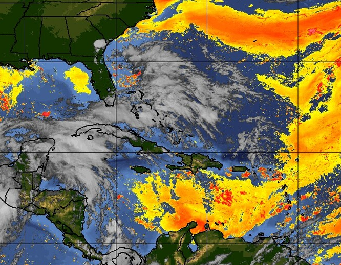


A sea of moisture.
A tropical stream of moisture.
Moist, humid, tropical air still there.
Agatha doesn't want to die.
She crossed over at the exact best spot.
Sneaky storms usually have a 2nd act.
Katrina hit Miami, then the loop current...
...and kept on going!
Luckily we aren't expecting a Hurricane soon.
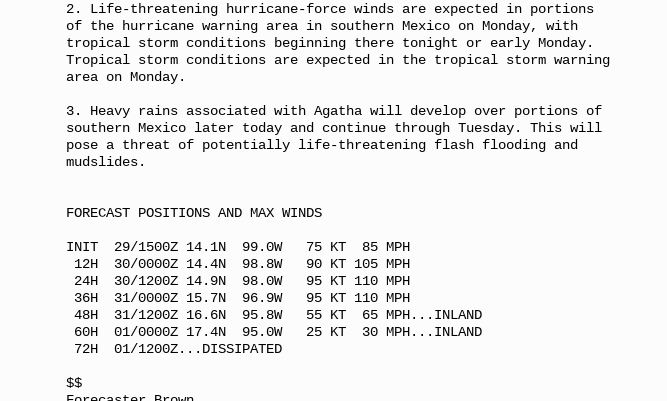
But Agatha set records for strongest, earliest storm.
What other records does she want to break?

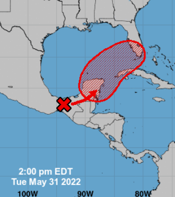
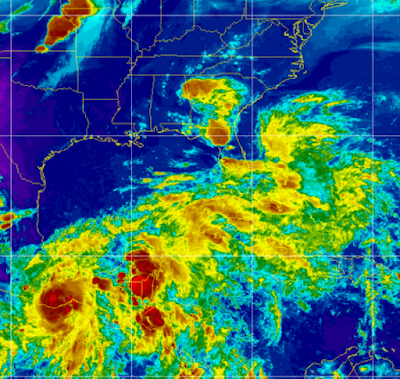
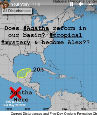
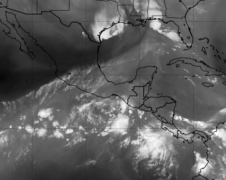
Things to consider regarding the red suspect area of development, current at 70% chances, that will most likely develop at least into a Tropical Depression and possibly TS Alex. X Agatha is easy to find, to her NE there is another mid level sort of circle over the Yucatan. 


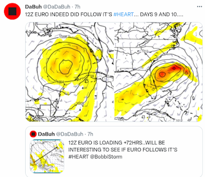
This image shows the 2 areas well. 


Sort of like Twins jumping rope.


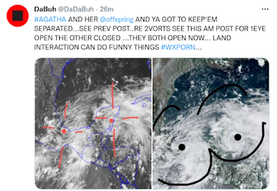
Dabuh has a way with words and um images.....
...we've discussed this all day online.

Things to consider now and always!

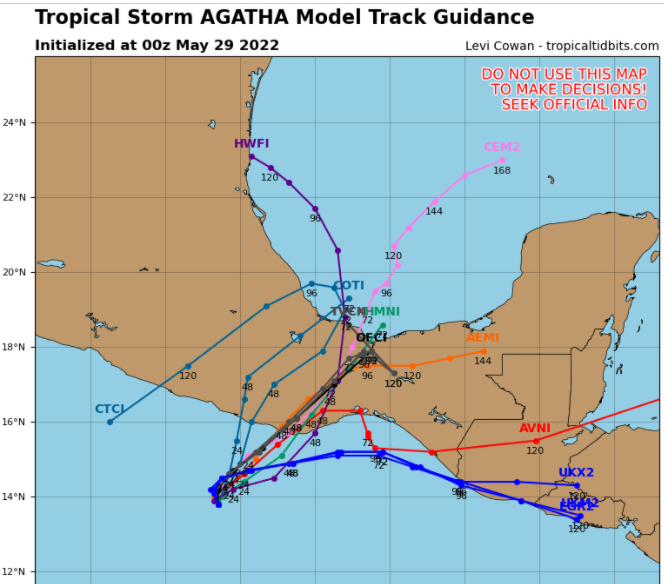
1. You need a center of circulation for a cyclone to form. Think of it this way. You know you have those days where you are all over the place, start 3 projects, don't get any finished and you feel stressed and annoyed and that makes it even messier. Currently X-Agatha mingling and competing with another area I have pointed out today often online. 

2. Models way before a system has formed a center spit out different solutions that we try to make sense of and in this case it's kind of clear what the problem is. The EURO catches one "center" closer to where Agatha emerges and the track it takes is further to the North crossing Florida at Rush Hour on the Beeline Expressway from Tampa to Daytona. The GFS may be latching on to the smaller vort to the right that has been there for a while (consistency is everything) seen easily in Dabuh's Weather Porn.  No I don't think he's making Tee Shirts with that image........see Mike for Tee Shirts.

3. Water temperature is everything and can make or break a developing cyclone. It can crawl along, coughing as if it's out of gas or it can ramp up suddenly like a sexy red sport car if it travels over the Loop Current.  This year's Loop Current is especially troublesome and one reason we do believe that combined with a strong La Nina that favors a very busy Hurricane Season in the Atlantic that we are a bit more concerned than usual for most of the cities around the Loop Current ... Florida and Gulf of Mexico. And, what forms near Florida and travels across the Loop Current doesn't stay in Florida, case in point being Hurricane Katrina. With regard to this little piggy.... IF it takes a track over the Loop Current (more like the EURO was suggesting) it would be stronger. Further South and East it would be weaker as the GFS suggested. Recently, the EURO decided to perhaps consider what the GFS has been selling and after possibly seeing the Dabuh's graphics it may have had a second thought. But again ... LOCATION matters. The formation of the center is the location the better models will run off of and give us better data. When the models begin to finally agree, and they will, then we will have a Cone and a solid idea where it's going. Til then some of us are laying low resting... such as Mike :) immortalized now in this image.


NOW THAT'S A CONE TO REMEMBER!!

4. Rule 4 is "Garbage in ... Garbage out" and any computer programmer will tell you that as well as possibly try printing out their own tee shirt of Dabuh's masterpiece with little Xs and Ox. Babyboomers will definitely understand that, sorry Millenials... 

5. Shear.... This actually links to timing, as shear changes in real time so once this forms we have to see if shear is light (enhancing development) or strong (inhibiting development).

6. Wild Cards ..such as MJO that most everyone loves to talk about except for Jim Williams who is not a fan. 

7. SAL. SAL moves the same way and same direction tropical waves move. Currently there is an opening, a window of opportunity for development. Where SAL goes  provides a clue where the waves will also go and when there's an opening... as SAL begins to lose it's grip on the tropics... that's where the big Westbound African Waves will go ... usually.


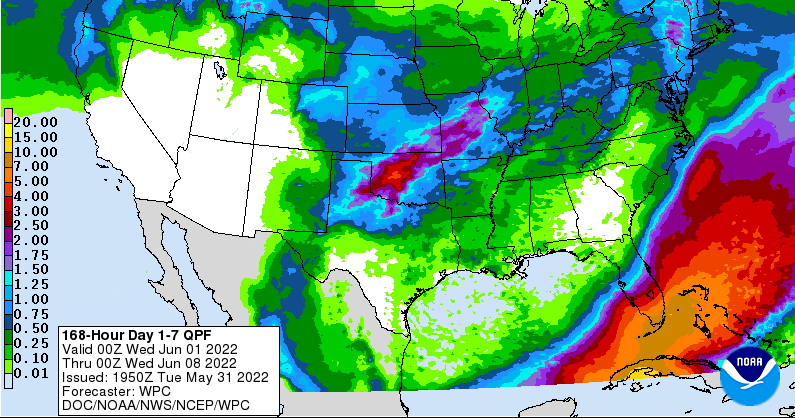
8.  It's frustrating that we cannot be exact at this point as much of South Florida has been swamped with flooding rains daily and it needs another 8 to 10 inches of rain from a Tropical Depression or TS like a hole in the head to quote an old saying. When it rains it pours and this is the Rainy Season, Monsoon Season in South Florida . The forecast for the next 7 days shows South Florida swamped with heavy rain and it may end up looking much like the swamp that it is so don't say I didn't warn ya. Yes I said swamped twice because I cannot emphasize the problem enough.  Welcome to Florida to all the New Yorkers who recently moved there.


Looks a bit like a Red Moby Dick doesn't it?

On a personal level I've sort of resolved my Gmail issues (thanks for the prayers) and I'm currently lying in the bed under the fan typing on my laptop trying to hide from the heat and trying to plot my escape from Raleigh where it  is forecast to be way too hot all week. Doubt I'll leave but I'm kind of in a pretend vacation state of mind.  I told my husband to pick up dinner and surprise me! I'll provide the drinks ;)

Much love, prayers for patience as I do believe the 2022 Hurricane Season is going to have way too many hurricanes and tricks up it's sleeve so order Happy Campers (herbal pills from Health Food Store)  or stock up the ice chest with your favorite beer and continue to figure out how to deal with Hurricane Season being Hurricane Strong and prepared. If you were a scout you'd know that... no badges here, no tee shirts just a song or two to lighten the mood. Oh speaking of ice... Mike has a deal with 30% for generators from one of his sponsors. No more ice when the power goes out ... 

South Florida most likely will deal with SOMETHING a bit more tropical than just the regular May Monsoons sooner rather than later.

Besos BobbiStorm

Follow me on Twitter and Instagram @bobbistorm

2 songs tonight


A classic hurricane song........
...Chow for Now!


60% Chance of Something Forming. Florida Pay Atten as Models Track IT (ALEX??) Across Florida. Tomorrow if June 1st Hurricane Season Officially Begins in ALL Ways


2 day on the left. 5 day on the right.
60% chances of formation in 5 days.
Why does everything have to be complicated.


Models currently.
Again nothing has formed.
Until a "CENTER" forms models are IFFY.
IF TD1 forms or TS Alex forms.......
.... stormy weather could be displaced far from the center.


See this is the problem, unless this wraps up into some neat strong Tropical Storm, the weather may be everywhere and when I say "weather" I mean STORMY WEATHER. If you live in the Miami to WPB area you know that you have had heavy rain and storms for days so this isn't much new but it adds to the misery. If you think it was flooding yesterday, wait until you see Saturday!!


This is the forecast discussion out of the NWS at Key West (some of the best mets around are there in) as they say "all forecast weather elements will be highly sensitive to the exact track, size and strength of the this low" and that's exactly the bottom line. 

Until it forms a center and we see how much weather wraps around the center and the size of the system (size matters) and the strength of this system it's impossible to tell you exactly what will or won't happen. We aren't talking Andrew or Wilma or Katrina we are talking an early June tropical system coming up from the Caribbean/GOM area towards Florida with possible impacts to Carolinas and the Georgia coast in some way later down the tropical road. 

I'll update this blog later today with more information, hopefully a more exact time line. Agatha is still struggling her way over mountainous terrain trying to get back into warm water.  It has a small window of opportunity as there is a break in the SAL (Saharan Dust) but be aware there is a bit of it where this tries to form that will keep it intact, then it travels over the various loopy currents of warmer water while trying to find it's groove.


Loop Current.
Current wind profile...NOTHING THERE.


Tomorrow I will talk on the Loop Current more.

I'll update later today.

On a personal note I culdn't sleep last night due to a bad sinus headache that became a stress headache that kept me awake. I may or may not have changed my main gmail password by accident ...or not. But, I was locked out this morning and though they did let me into my blog (YAY) it's been a tiring morning. Can I just start over?   Hey...that's what Agatha is saying too!!! 

Besos BobbiStorm

@bobbistorm on Twitter and Instagram


Ps... I need a tropical vacation............


Monday, May 30, 2022

Agatha Made Landfall. Alex Forming in Carib Moving Towards Florida? Carolinas? or Bahamas? Stay Tuned. Models Change in Real Time. Do Hurricane Prep Now for 2022 Hurricane Season June 1st!

50/50 chances for development. 


50% Orange... across a wide area.
Agatha has made landfall!!


Bottom left is Agatha overland, directly to her North is extremely dangerous weather now over Minnesota, around the border lands between South Dakota and Minnesota.  Across a wide swath of watery real estate is the mess of convection to the NE/ENE of Agatha. Note the HUGE bright red BLOB over the tip of the Yucatan far from the center of Agatha.  It's a very complicated situation and extremely moist as Mike likes to say and because of that there is a very good chance that "SOMETHING" forms, pulls together and dumps even more rain over parts of Florida, South Florida and the Bahamas than it has already seen all week. 

Rather than look first at models for tropical develpment, let's look at the rainfall predictions for the next week from the models.


The EURO covers a good part of Florida in rain accumulations. It's further to the North than the GFS that keeps the rain accumulations further South and East as seen below.


There is so much I could say, yet my tomorrow evening everything could have changed or it could merge a bit closer together. Honestly, the models are not that far off and they both develop "something" in the same general area. It's not like one is taking a hurricane towards Texas (as one did the other n ight...) or recurving into the Tex Mex Border or seeing nothing.


GFS flirts with South Florida on Saturday...
then moves fast out to sea on Sunday


The EURO........mighty EURO is below.


Displaced convection to the East over South Florida.
"broad center in GOM"
Then......
....WHAM pulls together some.


And here's the big kicker to think on...
Check out Monday!

Lashes OBX Carolina Beaches.
Delmarva and NJ beaches heavy surf.. 
...on Tuesday.


Finally shuffles out to sea.

We definitely could see Alex.

Tropical Storm?

Hurricane?

Subtropical?

Only time will tell.

I post this tonight because I want a record to look back on for myself, for you and for anyone who might learn from this how hard it is to forecast a named storm that has not formed. Westbound tropical waves leaving Africa with good model support are so much easier to deal with than storms in June that form from the CAG GYRE mixed up with old dead frontal boundaries that refuse to leave South Florida and slowly try to pull together into something. 

We are modeling, and surfing the models and thinking on every analog storm or year that might help us make sense of it all tonight.

Hope you all had a good Memorial Day Weekend.

I did but I'm spacey, moody and wanting right now and dealing with allergies and sinus and wanting to get away somewhere if only I could figure out where.

Tuesday and Wednesday it becomes clearer.

Saved the best for last.
Comapre and contrast this with Wednesday's models.


You can probably see the cone in your head.
Unless somethng changes.

Stay tuned.
Besos BobbiStorm
@bobbistorm on Twitter and Instagram


https://www.youtube.com/watch?v=_zBwRDEFMRY music link if it didn't load...


Sunday, May 29, 2022

30% Yellow Atlantic - Hurricane Agatha and Models That Show Possible Development in the Atlantic... Agatha DNA or Just CAG GYRE Related... Something to Watch


Above we have a yellow 30% circle around the Yucatan.

Down below we have the cone for Agatha!


Isn't Mike from Spaghetti Models wonderful?
The juxtaposition on his site is perfection!!!


Hurricane Agatha.
Check out that neat circulation and eye!
Discussion from NHC below.
105 MPH...


Before going further I want to point out that models do show something could develop, possibly, in the Atlantic Basin that could come together directly from the remnants of Agatha. Please remember, Agatha currently is a small, well built hurricane that may not make it intact in any way across Mexico. Depending on the exact tract models show it finding the narrow path and others take it the long way across the Yucatan Peninsular. See models above and I will show more below. It's also possible that a random piece of energy in the Central America Gyre tries to come together with or without the DNA from Agatha. 


The CAG often spits off pieces of energy that IF they get over warm water and relatively light shear in an area without heavy Saharan Dust can often form into a named storm or Tropical Depression. Either way an area of interest is expected to show up soon in that part of the world. Just as the GFS fantasized about a Hurricane forming, the EURO has been doing the same with this set up. We continue to watch each run and we have plenty of time to watch before anything actually forms. And, there is a general SW to NE orientation as seen above of this moisture trail that slides off the CAG and at the same time the remnants of an old frontal boundary.


Every run is slightly different, but this run of the EURO shows a broad circulation in the GOM and a large area of thunderstorms over Florida and the Bahamas down the road. On that same road the GFS cooks up something a bit different suddenly showing up South of Cuba.


Then days later it ends up in the Bahamas.


In the image above you can see moisture/thunderstorms on the NE side of a small circulation sort of center (very iffy) that may or may not come together. In ways the GFS and EURO are fairly close together on a mass of moisture and a broad center area that doesn't seem aligned in any way but bringing WEATHER to the same general area.

I've often said that after a storm forms in the EPAC the Atlantic side comes alive 5 to 7 days later. Sometimes on rare occasions, that's because part of the DNA energy if you will crosses over and helps spark development. More often it's because when there is something on the West side of Mexico there then shear is stronger on the East side of Mexico and that inhibits tropical development on the right side of the EPAC system that is close in to the coastline. The atmosphere can only support so much energy in June and shear from an EPAC storm inhibits development in the Atlantic, no matter how warm the water is that is worth remembering. 

Crossover storms do happen and the link to the list of all the storms is shown below. 


It happens usually in August and September and again these are Hurricanes not Tropical Storms and again a well developed hurricane has more... let's say Oomph to it to help keep it together. Noticed 1988 had two such storms. June may be too soon for an actual crossover event. However, the general CAG may help develop another area of Interest that becomes an Invest that we watch to see if it can get it's act going.

Stay tuned!
Fun times in the tropics ... use Memorial Day Weekend Sales to stock up on things you may need for your Hurricane Supplies. Paper Plates... canned food, snacks, outdoor lanterns, citronella candles to keep the skeeters away when you are dining outside because there is no electicity in your house. Don't say I didn't warn ya...

Besos BobbiStorm
@bobbistorm on Twitter and Instagram

Ps ... Come Monday we will know more on the possibilities!


u saw that comin didn't ya??


Saturday, May 28, 2022

TS Agatha Forms in the EPAC - Yellow Circle 20% UP In BOC. Can Agatha Help Light the Spark for Alex? A Tropical Mystery... Stay Tuned...


TS Agatha forms in the EPAC!
1st named storm of 2022!!


This is the real question below....


Borrowing from my Instagram...
20% Yellow in the BOC IF Agatha can do the deed.
Models are messy.. but consistent.


EURO Model on it!


GFS had it's Fantasy Cane....
...is the EURO fantasizing or onto something?

Bottom line here is that it does happen but it's rare. Sunday I'll discuss this in depth but it's definitely something to wonder on and Agatha is expected to be a Hurricane.


www.windy.com tonight shows this for Monday.
Tight little storm.

iCyclone is hungry, he's in place already...


2022 Hurricane Season has basically started though the official start is June 1st. Stay tuned, prepare whatever you need based on your own priorities and I'll update Sunday Morning. Just marking the moment when Agatha formed in the EPAC along with the models currently toying with taking it into the Atlantic Basic. 

Sweet Tropical Dreams,
BobbiStorm
@bobbistorm on Twitter and Instagram


Wednesday, May 25, 2022

EPAC Dressed in Red, Atlantic Quiet For Now. Does Remnant Moisture Get Into the GOM? Maybe. LONG LONG Range, Today it's Quiet.


Nothing expected in the short term.


Long range models have been sniffing out something in the GOM that could be remnant moisture from the system that is forming in the EPAC and crosses Mexico.  You can see the system highlighted in red that is primed for development and you can also see where the land mass of Mexico is narrowest. Should this form and cross that land bridge, as many early systems try to do, any remant moisture ends up in the Bay of Campeache and could develop. Long range models are very iffy, but they show the pattern and possibilities. And, as I have said a million times online, patterns are everything. Sometimes patterns produce named tropical storms exactly on the start of the Atlantic Hurricane Season on June 1st and other times they deliver heavy tropical rain with flooding and severe weather warnings. So basically we are in a watch and wait period. I often always say "when something forms in the EPAC" you can usually not expect anything in the Caribbean or Gulf of Mexico to form (due to shear and other issues) and count five days to a week and then look for development on our side of Mexico and Central America.


Just a quick reinforcement of what I said yesterday in a longer blog, the sharp diagonal line seen above that runs SW to NE is shear and dry air. Warm moist air is to the South where the two candidates for development are being monitored by the NHC. The blob over Texas is a blob, too much shear and dry air there currently. Anything that does form in the EPAC will move inland and again remnant moisture could develop down the road, way down the road. 

Time will tell.

The huge Low in the Atlantic is still anchored there and waves are still coming off of Africa. A front is forecast to move down over Florida further lighting up the sky with thunderstorms at the end of this week and generally this time of year the fronts go flat somewhere and as always we watch decaying frontal boundaries for possible, home grown development.

A brief note on Texas......  
It was very sad, upsetting watching the horrible, deadly, developments that came out of the news story yesterday. Offering prayers for the people there who all know each other well and their lives are extremely entertwined as are lives in a small community. Some may say prayers do not do anything, but personally I think they do and it doesn't do any harm. The violence needs to stop, anger and hatred need to stop. And, more so I fear with every event such as this there is some copy cat tragedy and that too has to stop. It just has to stop but for now I send prayers, good thoughts or however you perceive that.  I don't usually go political on the blog, but I don't think this is "political" I have no "agenda" I'm just responding as a person, a mother, a human being saying I didn't do much weather watching last night. I so prefer weather over the news sometimes.  

Besos BobbiStorm
@bobbistorm on Instagram and Twitter

Ps Please reread the blog from yesterday if you have not as it is more indepth into why it's currently quiet in the Atlantic side of the Hurricane Basin. And, that also explains what to look for the why and when things get busy vs staying quiet.

Music link... Gee BST again.


Tuesday, May 24, 2022

Why I'm Watching the GOM BUT Not Obsessing. CLIMO vs Flare Ups of Convection. Atlantic Spinner . Clean Up in the Carolinas Today.


NWS Radar Site shows a huge blob off Texas.


So just to look at the satellite and radar images off the coast of Texas it would be easy to be concerned that something might develop there if that convection lingers over warm water. That is true, but currently shear is strong across the region and an area to the South of it in the EPAC has higher chances of forming. Add in the Saharan Dust as if you put too much pepper in the soup and you'll know that no one is going to drink the soup. 


On the shear map above red means "no" and that shear is only increasing. If you saw a greenish blue area with broken lines there vs reds and oranges then shear lessening and it would be more favorable for development. Below you see the Saharan Dust that has made it's way into the Caribbean and is cloaking parts of the SE and Gulf of Mexico.


Flow around the huge high keeps propelling the SAL seen above.


Add in the fact that the EPAC has a huge blue/purple blob on the map above and as you can see from the pervious image there is consistent convection in an area that is favorable and aligned with CLIMO as their hurricane season began on May 15th and usually they fire off tropical development before we do. When something forms there in the EPAC it creates shear and further inhibits development in the GOM and Caribbean. On some rare occasions a storm in the EPAC can cross the narror region part of Mexico and end up in the BOC or even the Caribbean but that's a long shot but one worth remembering as it has happened in the past.  Extra Credit points today to the small purple dot in the middle of the Atlantic.


It's hard to ignore.
Looks like the Red Spot on Jupiter!!
Also note a Westbound tropical wave.
Low as it goes but its there.

One thing to understand regarding weather is it's a lot like life. My father told me once that you don't always marry the person who would have been best partner for you, but you marry the person who comes along when you are ready to get married. I'm not 100% convinced on that, though I do see his logic but that applies to weather and especially tropical weather. Incredible, kickass, OMG tropical waves can come off of Africa in late May and more often in June yet it is too soon and Dusty SAL eats them up and spits them out. Then later in the season when it's more favorable, mediocre waves come off that are not as pretty or exciting yet CLIMO kicks in and they develop and struggle their way across the Atlantic attaining a name and fame.


You may wonder why I am showing you why the suspect area in the Gulf of Mexico is not expected to develop,  rather than show you what will form and that is because currently nothing is expected to form and it's important to understand what inhibits development. Because, when those conditions are absent development will occur. You have to know when to hold them and when to fold them, you also need to know how to prepare for Hurricane Season...


Timing is everything.

That said........if you ever played Miniature Golf you will know that if you want to get the ball through the turning windmill you have to learn to time it perfectly or it shoots your ball off the course and you have to go looking in the bushes for it! When SAL wanes a bit and it does as explostions of SAL come off of Africa in bursts that pulse, they undulate and then they shrink down a bit until the next huge explosion of SAL comes off the coast again and it presents short term opportunities. Kind of like Day Trading vs buying stocks you expect to make money in the long term. Shear weakens just enough and over warm water you can get a spin up and a brief period where the elements can come together in June despite it being generally too soon (re CLIMO) and something close in, homegrown develops or a nice looking tropical wave gets a chance to cause damage down the line............if conditions are right for a few days. Sometimes Subtropicsl Storms form in the Atlantic. They are usually forgotten once the long range cruising waves develop and become long trackers and make landfall somewhere on our shores.

It's all in the timing!!

Regarding weather and the Carolinas...............


Yesterday in Raleigh.
Huge trees crashed down on homes.
Localized severe damage.
I watched small branches fly in the wind tho... 
Tornado Warnings.
Straightline Winds.

I was offline yesterday dealing with local severe weather. The sky was dark, the storms moved in and either straight line winds or a small tornado caused damage in the general Raleigh Triangle area. I saw sheets of rain that looked quite tropical, yet the wind was only when it rained. It rained heavy, flooded certain areas that are prone to flooding and huge oak trees crashed down on homes, trapping people inside. Over 10,000 homes lost power, mine flickered but held. This has been a pattern, almost every Monday there have been crazy storms and then once or twice during the week. The current strom track has propelled everything this way and generally that's good as we need rain but not when oak trees crash down on homes. It's been wet.

I'll add the SC/NC border near Spartanburg and Johnston County ...that region has been plagued by wild weather for weeks and it's making me wonder what else will come ... come Hurricane Season. Briefly, during the storm yesterday I saw the wind change directions (in sheets) of rain and watched small limbs fly off of the nearby Oak Tree, definite rotation close to the ground and a bit up the road from me later was a Tornado Warning.

Stay alert, keep preparing for hurricane season. Yesterday while moving things around the house a bit doing some redecorating I put together all the good batteries and removing the ones that are old. I corralled some of the candles in pretty glasses into one area so I'll know where they are in case we need them. Also, our lights were flickering so it reminded me to check into the batteries for the hurricane season.

Be well, stay hurricane strong. 
I'll update if the NHC puts up a random yellow circle today somewhere unexpectedly, but they said not to expect it so keep that in mind.

Besos BobbiStorm 
@bobbistorm on Twitter and Instagram.

Ps....re the Atlantic....yes as Dabuh sang last night... spinning wheel got to go round....


B, S & T always and forever.... yah..