Hurricane Harbor

A writer and a tropical muse. A funky Lubavitcher who enjoys watching the weather, hurricanes, listening to music while enjoying life with a sense of humor and trying to make sense of it all!

Monday, May 30, 2016

Updated Tropical Storm Bonnie Wrap Up. Caribbean GOM Action Coming Soon.. Possibly Colin.

ft_lalo-animated.gif (720×480)

That's Bonnie, flaring up, dying down.
Will she flare up again?
Small possibility.
If so only briefly if she hits a warm spot.
But NHC is no longer doing advisories.

So Brief wrap up here on TS Bonnie.

She did cause some localized flooding.


If you were stuck on I95 for 35 miles you'd think this was big.


Loops do show a closed circulation.
That's why they did the upgrade.


Last advisory written....


Models did a good job of sniffing her out.
Not thrilled with NHC forecast that was a bit off.
But won't split hairs on a beautiful weekend.

Next storm could form in Bahamas or in Caribbean headed N into GOM


This is REALLY beginning to feel like 2012 again. 
Deja Vu

Time will tell.
But it's name is 2016 Atlantic Hurricane Season.
As we go into the official start of the season..
We are on Storm 3.... 

Stay tuned.
Game on..

We can talk about that after the holiday weekend.
Hope everyone is appreciating life and good weather.

Besos BobbiStorm
@bobbistorm on Twiter

Cute movie.
Probably on Netflix


The name Bonnie will remain on the list.


Tropical Rain from Bonnie on East Coast and Texas Storms. Next week possible tropical formation again. Enjoy the Day!


p120i.gif (750×562)


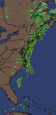
The big story for the next day or two is the heavy rains that will be falling along the East Coast beaches and coastal towns.....and Texas. Texas will be getting huge amounts of rain. I put the word Texas together there twice as it bears repeating. On the East coast we are getting "tropical rain" and I say that because that is what they said last night on the local radio station in Brooklyn. Tropical rain moving in our way from the remnants of Bonnie. Or perhaps we could call it the weather area associated with the remnants of Bonnie. But it did rain heavy last night in Crown Heights. It might still be raining, but I'm in the basement looking at loops of the Caribbean not local radar loops. Go figure huh? Okay I just checked the radar loops. Yes...there is tropical rain. And that is mainly the legacy of Tropical Storm Bonnie. Rain and rip tides along the beaches... off and on over the Memorial Day holiday.


In most places it won't be enough to keep people away from the beaches.
Out of the water maybe but sun tanning, BBQ and play time is fine.


Ed Piotrowski says it all with pictures on Twitter.


Look at that sunrise 3 hours ago in North Myrtle Beach? Wow.

So there's a little tropical rain...

There may be a system forming this week...
Think very long term.
Think long shot.
Think models.


I'll say currently when that many models agree.. it's worth watching.
Above he says the CMC is on drugs and many agree.
You read a lot of funny things on Mike's Weather Page on Facebook.
People from all walks of life.... 
From weather lovers to professional weather people.

He hit a big milestone this weekend.
He has 65,000 fans.

Let me put it this way.
Mike from TWC has only a few more.
Not that we are competing just saying...


So I decided to highlight a post from his Facebook to show the model.

It's possible and not all that improbable.
How strong of a system is the question?
Stronger than Bonnie?
Probably.
Look at the water temperatures in the GOM.
Then subtract points for possible shear.
The answer is keep watching.

at_sst_mm.gif (640×400)

From the Caribbean up through the Yucatan and into GOM...
Warmer oranges over a greater area.
I'd say the area is primed for development.
Yet there is shear always.
So keep watching.
But models do agree on formation for now...

http://www.windalert.com/en-us/Search/ViewResults.aspx#35.193,-85.554,4,18

I have some anal retentive friends who ask me...
"Why does he move things around so much? Adds sites?"
Answer is he watches what his viewers are interested in...
...and Mike adds in links he feels are valuable.

Where is it?
Follow the Red Road down down down....


Great link... play with it.

As for me I'll be playing today too.
My kids who went camping in the mountains are back..
I have money I need to spend on Kingston Avenue..
Going shopping... hanging out.
Enjoying Memorial Day and remembering...
Those who made this day possible.
Our soldiers who fought for our great quality of life!

So give thanks. Enjoy.
This coming week we can obsess on the models and more tropical action.

Today... go play in the tropical rain!
Be safe but smile and send pics!

Besos BobbiStorm
@bobbistorm on Twitter

Saturday, May 28, 2016

UPDATED...Tropical Depression Bonnie Barely Moving on SC Coast.

Not much to update other than Bonnie has been downgraded to TD
Still lingering on the coastline... moving Northish up the coast.
If it gets out over water it could redevelop a bit...tho waters coolish.
What would you like me to say... it's an "ish" system.
What I will say is the end game has a wide spread.


Bonnie remnants could be out to sea...
or raining for days causing localized flooding.
Stay tuned.

Water temps here tell the story.

at_sst_mm.gif (640×400)


To the south there is a flare of convection without a center..
..that's fun to watch.


The Bahamas may be a breeding ground for a while.
Will see.
Texas again getting heavy rains.
And a bit of the old "fire hose" set up for Carolinas.
Moisture funneling in from the SE

I hate to quote Mister Ed but...
I'll update later when there's something to say.

Have a great Sunday, enjoy it.
I'll update as events change if they do.

Besos Bobbistorm
ps... keep reading my logic is the same below as last night.


Tropical Storm Bonnie is the cloud mass by South Carolina.
NOT the 2 round balls in the Bahamas.
Just being clear here.
Bonnie is a very weak.....
....barely there Tropical Storm.


Intensity seems to have verified.
Track has changed a drop in timing not location.
Yesterday Bonnie was moving slower to the coast...
...then that shortwave trough forecast to pick her up..
Spoiler alert...the shortwave trough not mentioned tonight.
Note Discussion from NHC below...

"cyclone should begin to move north-northwestward and then northward
during the next 12-24 hours between a mid/upper-level trough
and west of Bermuda. advancing into the eastern United States and 
a building ridge near"

Don't mean to split hairs here... 
...but they usually are big on continuity in discussion.
Either way if you look at yesterday's cone vs today 


Now it's at the coastline.
The time line is slower. Much slower.
Might be downgraded but the rains will persist.
My original concern but it was supposed to move faster.
Will...could mess up the holiday weekend financially.
Unless locals decide it's barely a tropical storm and go anyway.
Wonder if the State of Carolina can sue Bonnie?
Just being silly but much to do about nothing.
Nothing right now... 
Still concerned on localized flooding.
Especially with a system barely moving.
See more NHC discussion below.


Radar image...


Not an impressive radar signature.
I'll be back Sunday morning later with a longer post.
More discussion and we will see what Bonnie looks like then.

Besos BobbiStorm
@bobbistorm on Twitter

Ps... looks like the name Bonnie will be staying on the list again.


Friday, May 27, 2016

TD2 Forms in Atlantic Headed to SC & SE Coast. Should be Bonnie by Tomorrow. NHC keeps it at 45 MPH.. we will see.


Welcome to the continuation of the 2016 Hurricane Season.
2 systems before June 1st.
Beginning to remind me a bit of 2012 Hurricane Season.
Different but similarities 


With La Nina coming on we could have a very busy season.
Basically the coast of South Carolina is now under a Tropical Storm Warning.


Note that would include the Myrtle Beach area a favorite Memorial Day town.

It's not as yet a photogenic system.
Give it time and warmer water.

rgb-animated.gif (720×480)

One concern I have is the models have swung from way inland ..
...to hard right turn and riding the coast.
Riding the coast would keep part of it over warm waters of Gulf Stream.
That could keep Bonnie a player longer than had she headed inland.


I outlined the track in yellow but other models do exist and persist.

http://www.wpc.ncep.noaa.gov/basicwx/day0-7loop.html

That's a tricky tango dance step scenario for that track to verify.
It may verify. 

It could pull north a drop of Charleston if that forecast hook is viable.
Either way small tropical storms are messy no matter where it makes landfall.

Discussion shows the steering currents.
If that erosion of the high exists and the tug of the shortwave verifies..
It could make a sharper turn right.after landfall.
IF the shortwave is not as strong it could move slower ...
...and less sharp a turn.


That is my discussion on the concerns on the strength of the short wave.
We will know more tomorrow after TD 2 consolidates better.
More consolidation and more evolved center of circulation.
After a forecast upgrade to Tropical Storm Bonnie.
TD2 needs a bit more of everything right now.

I believe it will be a bit stronger.
If it hits 45 MPH it will hit 50 I believe.
Again it needs to totally form for a good forecast.

Models are conservative.
That's funny as they are bullish on formation.
Yet conservative on intensification.


I was concerned on flooding with previous models showing it moving inland.
Cantore said it shouldn't be widespread flooding.
Hope he is right.


And it is a sharp right turn. 
Let's see if that verifies.
It's hot in Brooklyn. Very hot.
Extremely hot.
Even by the water it felt like Miami hot.
Tropical hot. Humid hot.
Beautiful but HOT.


Incredible Brooklyn Bridge Park.. 
But... it feels more like late June than late May.
So curious on that tricky trough two step that pulls Bonnie.

I'm hopeful the track is right but a bit skeptical.
We will see tomorrow... if Bonnie is dancing with the trough.
We also will see if Bonnie is indeed Bonnie.

As for the NHC Forecast for this year..
..we can discuss it in depth when there is no system with advisories.

You can read the NHC forecast for this year.
Near Normal.
I'd go with slightly above normal. 
Time will tell. 

http://www.noaa.gov/near-normal-atlantic-hurricane-season-most-likely-year


Besos BobbiStorm
@bobbistorm on Twitter... 
..in Brooklyn!

Will update tomorrow evening.


Crazy busy... if you come to visit try it out.
Views of the bridges and Manhattan are awesome.


90% Chance Invest Becomes TS Bonnie. Caught Like a Ball in a Cesta Thrown at the SE Coast. Perspectives on Hurricane Sandy and NYC


That red x issued at 8 am by the NHC is for within 2 days.

Formation chance through 48 hours...high...90 percent

The track for now remains the same.


The center is slowly coming together.
Hurricane Hunters will be going in this afternoon.

As I said yesterday it has to move over warmer water...
...get closer to the coast where there is less shear.

Doesn't look like that much now but it's a process

vis0-lalo.gif (720×480)


rb_lalo-animated.gif (720×480)


Going wide you can see the larger picture.
I like the larger picture

Sort of like a rookie quarterback in the pocket.
Needs some maturity.

wv-animated.gif (720×480)

Models are seeing the future... predicting the forecast.
Note how it will be propelled towards the Carolina coast.
Think of a Jai Alai player in action.


Once the player catches the ball gets caught in the cesta
(that wicker looking basket on his arm)
He's swung around in a curve motion towards the wall.
 Bonnie will be propelled towards the coast in the same way.
Most like this will become Bonnie.
A player in her own right but caught up in the atmospheric currents.

Models are doing a good job this season at sniffing out development.

sat_wv_east_loop-12.gif (640×512)

The process is more apparent here in the bigger picture on the long loop.

There is a small chance, currently small...
..oddball chance Colin could be develop.

I'd put that between fantasy and who knows . . . for now.

jsl-animated.gif (720×480)

A sort of extra credit project while watching the loops and the Invest.

It's important to remember for now this is an Invest. 
An area being investigated...Bonnie is the name it would get.

at201691_model.gif (640×480)

Bonnie because we already had the A storm in January..
For now models take it inland and then back out to sea.
Strong, messy weather for the DC to NY metro area.
Possibly Boston and Cape Cod.

Again the problem is has currently is two fold.
Water temperatures are only marginal.
Then you see that deeper red orange tongue of color?
Close to the coast..
...approximately where shear lessens.

at_sst_mm.gif (640×400)

There are two dangers with close in...
One is obvious it develops on the coastal doorstep.
Secondly while developing it sucks in a lot of moisture.
Tons of tropical moisture.
So from a relatively weak system you could have a large flooding problem.
In an area that had flooding earlier in the year.
Understand the problem?

This is not Hurricane Andrew chugging to shore as a Cat 5.
But it still has the potential to wreck the Memorial Day Beach Party.
A big economic problem.
And further inland as it rains and rains... cause possible flooding.
Just a possibility to remind you weak systems can be a pain.

As for the big picture that I love.


Note IF anything developed further in the Bahamas.
It's a long shot but even the thought that the Atlantic can cough up 3 systems.
Before the Epac barfs up even one ...
Is a sign that El Nino is on the decline, disappearing ....

A real long shot but worth a mention.

Note the Epac most likely will have a system soon tho..
The weaker the Epac is the more energy is in the Atlantic.
You can see the swirling . . .forming below.. slowly
latest72hrs.gif (947×405)
The bottom line from the NHC

Salient points...
Getting better organized.
Recon going in.
A threat to the SE coast in general.
New update after 3 PM.

Worth mentioning also the big NHC report is due out later today.
We have the CSU report earlier in the year but the NHC waits...
So the official forecast discussion for the Hurricane Season is today.
I'll update this afternoon on the Invest and the report as well.


Again the NHC says tropical or subtropical storm.
Time will tell.

I just wanted to add on perspective.
It's a popular word these days but important.

I sailed the harbor yesterday.
Well it was a yacht but I was sailing :)

You really don't realize how close the World Trade Center was.. 
...how close the Freedom Tower is to the water.
From the water it is right there rising almost out of the water.

People staring up at the Freedom Tower...
Rising up at the edge of the water almost.
Caught in a traffic gridlock from a car...
..you lose perspective.
From the water you realize how vulnerable NYC is to a hurricane.


From the water it's like you can reach out and touch it.
Very vulnerable.

And speaking of vulnerable...
We sailed close to Breezy Point.
A sailboat out ahead of us.
A spit of land ... beaches... beautiful beaches.
Just there in the middle of the water.
Obviously a paradise close to the city on most days.
Almost all days... except hurricane days.

The air soooo fresh.
Such an awesome breeze.
Incredibly beautiful... 
At the edge of Queens and Brooklyn.
Paradise unless there's a storm surge.

Humbling even to me who knew and understood.
But to see it for yourself up close from the water..

Wow.
Oh and they have these pirate ships and boats to watch the sunset in NYC.
Everyone lined up with their cameras... 
...felt like I was back in Key West.

So know you can get a sunset cruise if you be in NYC.

Besos BobbiStorm
@bobbistorm on Twitter

Ps Got a laptop here to work on but not my normal one so..
Thanks for the patience while on my NYC vacation!


Thursday, May 26, 2016

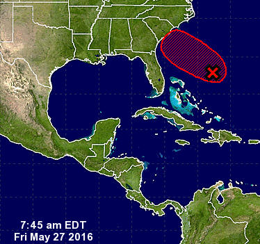
70% Bonnie For now models lock on Charleston then ...depends on Bonnie

Remember the old days when I used to write without graphics? I'm on vacation with many commitments as its a working vacation. I'm speaking in NYC and in theory the Hurricane Season doesn't begin til June 1st... Oh well on that theory. Isn't Mother Nature fun... She decides when the hurricane season begins unlike say NFL football season. No surprises there. Lots of surprises always with the Hurricane Season.


Surprisingly I woke up this morning to find out both the GFS and the EURO agree with my early all on Charleston. I have felt that was a more realistic landfall point than many I read others say. That said... Until this Low wraps, comes together (insert song cue) gels...all bets are off on the exact evolution ... Exact landfall... Exact end game.


Yes the NHC has upped the odds to 70 percent for the 5 day but beyond that much is up for grabs.


For example the models that are all over Spaghetti Models online show possibilities of Bonnie going far inland..and/or bouncing back towards the ocean staying with us for quite a while. The devil is in the details. Those are the details the NHC can't show in a red alert graphic nor can we see in our meteorological crystal balls.... Until Bonnie forms.


This morning you can see a slow coming together more like a collision of factors that will create spin and lift off.


As always timing is everything with tropical systems especially as it relates to long term track options.


Yes its Memorial Day Weekend and this may take a bite out of the holiday economics of small beach towns hoping to start $ummer off with a bang. Money flows like weather. People will go inland up to the mountains (Carolinas have so many options) or go to the movies are mall. Small great beach towns like Ocean Isles Beach may get the short end of the proverbial stick.


But some models show Bonnie going well inland towards said mountains while others show it cruising up the Interstate.


www.spaghettimodels.com has ALL the models that's where the name came from... Duh :)


Hurricane Hunters are scheduled to go in Friday.


Lastly think on this..
As this system presumably Bonnie finally gets a center and moves towards low shear and high water temperatures over the Gulfstream it will spun up FAST as these home grown coastal lows do. Sometimes they meet expectations and sometimes they exceed them.


the Wonderful Weather Wizards of Oz I mean the NHC will speak again later tho afternoon. Til then enjoy the day and the loops.


I'll update when there's are more details !!


Below is the discussion from the NHC.


Besos Bobbistorm
@bobbistorm on Twitter


Ps again thanks for your patience with any grammatical errors..


"With the Memorial Day weekend
approaching, all interests along the southeast coast from Georgia
through North Carolina should monitor the progress of this low. An
Air Force reconnaissance plane will be scheduled to investigate
this low on Friday. The next Special Tropical Weather Outlook on
this disturbance will be issued by 3 PM EDT today.  For additional
information on this system, see High Seas Forecasts issued by the
National Weather Service.
* Formation chance through 48 hours...medium...50 percent
* Formation chance through 5 days...high...70 percent"

Wednesday, May 25, 2016

still watching and waiting

ZCZC MIATWOAT ALL
TTAA00 KNHC DDHHMM
SPECIAL TROPICAL WEATHER OUTLOOK
NWS NATIONAL HURRICANE CENTER MIAMI FL
815 AM EDT WED MAY 25 2016
For the North Atlantic...Caribbean Sea and the Gulf of Mexico:
1. An area of cloudiness and showers over the western Atlantic Ocean
northeast of the Bahamas is associated with the interaction of an
upper-level trough and a weakening front. While development is not
anticipated for the next couple of days, environmental conditions
are expected to become more conducive for tropical or subtropical
development on Friday. This area of disturbed weather is forecast to
move slowly west-northwestward or northwestward and gradually
approach the southeastern United States over the weekend. The next
Special Tropical Weather Outlook will be issued by 8 PM EDT tonight.
* Formation chance through 48 hours...low...10 percent
* Formation chance through 5 days...medium...50 percent
Forecaster Blake
BobbiStorm's bottom line.
Not much has changed. Same logic.
some shear, water temperature not that warm yet..but will get warmer as it moves closer to the Gulfstream.


Say you have a lunch date. They took the ferry and are on the subway. They will get here but for now your are waiting.
Order a diet coke...they are on their way.
So is this coastal low that might be Bonnie.
apologies for any grammatical mistakes.
sitting in a deli waiting for a friend ;) and watching loops.


Besos BobbiStorm
Ps...NY values...hmmn..they won't take my order til the rest of my party arrives. Hmm who knew? What am I chopped liver??


Tuesday, May 24, 2016

30% chance of Bonnie forming off SE coast as per NHC

000
ABPZ20 KNHC 241732
TWOEP
TROPICAL WEATHER OUTLOOK
NWS NATIONAL HURRICANE CENTER MIAMI FL
1100 AM PDT TUE MAY 24 2016
For the eastern North Pacific...east of 140 degrees west longitude:
Tropical cyclone formation is not expected during the next 5 days.
$$
Forecaster Blake


my thoughts...


models have been extremely consistent in developing either a tropical or subtropical system. If named it would be Bonnie.


my logic from this morning is the same... North of Savannah..south of Wilmington most likely. Need a floater, an invest...next model runs important.


I'm in transit so this is a short heads up post.


please read my previous analysis for what most likely will happen.


Besos Bobbistorm

Question on Home Grown Trouble Memorial Day Weekend? Models speculating. Stay informed just in case..

sat_wv_east_loop-12.gif (640×512)

This is what the water vapor loop looks like Tuesday Morning.
System parked over the Mid Atlantic.
Plains exploding in their way.
Diving air down through the Caribbean.
Everything swinging around the huge dark hole low.

How do we get from here to there?


That remains the tropical mystery of today.

A lot of discussion about a "LOW" forming off the SE Coast.
I've read Florida.. Georgia.. Carolinas.
Models have been consistently hinting.
We have moved from hinting to graphics.

The above picture is from Mike's Weather Page on Facebook.
If you are inclined to want to share your thoughts......
....go share your thoughts 
https://www.facebook.com/mikesweatherpage/

Great place to get the pulse for what people are thinking.
The storm people who are hoping.
The general public hoping not.
Knowledge is power.
Power in this case means the ability to prepare.

So front moved down through Florida.
Front stalled out and went stationary over South Florida.


The high pressure ridge is to the North locks in rain to the South.
Always watch stalled out fronts late in the Spring.

On Tuesday the High pulls away a bit.


And a low pressure area of some kind forms.
Basically without the High sitting to the NE...
It fills in the gap.
Very basically.


Then the low moves back to shore.

Sort of like a cold front that goes stationary..
..and then a warm front goes north again.
Similar but different.
There's a tropical wave mixing with an old stalled out front.
2 basic ingredients for early season trouble.
Add in warm temperatures..ocean temps warm.


And that becomes the question.
A sort of quirky question with multiple choice answers.
Is this merely trouble from the tropics or a named system?
Usually it's just an early non tropical sort of low.
But sometimes in years like this we end up with named storms.
Way too soon to make that call but either way the weather is there.
Home grown brew is possible.
The next name on the list is Bonnie.
Tropical Storm Beryl did this in 2012.


I've seen it happen many times.
Each system just a little bit different.

The reason I showed these images is to highlight a loop.

http://www.wpc.ncep.noaa.gov/basicwx/day0-7loop.html

It's on Spaghetti Models down about halfway thru the page.
It's the official 7 day forecast the NWS uses to prepare your forecast.
It's a good indicator of future events and it changes in real time.
Well the 5 and 7 day change more than the other days.


Follow my red arrow I drew you above.

Remember the old AOL?
Favorites were little hearts you saved.
 I know dating myself here.
A lot of us grew up on AOL technically speaking.

One of my favorites is there.. 

latest72hrs.gif (947×405)

Keep watching that loop it's your tropical crystal ball!

Think of Mike's Spaghetti Models as a graphic of your favorites.
I really miss those little hearts.
Life seemed sooo simple. 
Being silly here. 
Seriously..

The possibility is there.

Personally think the rain is more likely to affect Charleston..
Just to the North or just to the South.
Anywhere from Jax to OBX is in it this far out.
Sorry to rain on your Memorial Day Parade there..

So far the NHC says nada happening.


There is a far off chance that something in the Caribbean catches our attention.
The NHC does highlight the wave in their discussion.


The dominate feature... 


Some people are watching that dominate wave.

I'll add regardless of where trouble forms it most likely will be home grown.


Whatever forms IF it forms.
Will be a Little Bitty ...
Maybe a little bitty Bonnie?


Might put an exclamation point on the start of the Hurricane Season!

Hope your Memorial Day is not a wash out.
At least it won't be like Labor Day of 1965.
Read my previous blog on Hurricane Betsy.
Betsy took a bite out of that holiday in Florida..
...and then kept going to Louisiana.

I'm going up to the Big Apple for a few days.
I'm scheduled to speak on a boat again.
Apparently I speak on boats.
Either way.. 
I'll be updating from the road.
Stay tuned.


Also check in on Twitter for fastest updates.
@bobbistorm on Twitter

The wait goes on for the elusive yellow circle.


My bottom line is it's all speculation until we see a yellow circle.
But we do all love to speculate.
Models are often the definition of speculation.

Speaking of speculation...
The new Star Trek movie looks really good..


Summertime... hurricanes and big movies.
Then comes football!