Hurricane Harbor

A writer and a tropical muse. A funky Lubavitcher who enjoys watching the weather, hurricanes, listening to music while enjoying life with a sense of humor and trying to make sense of it all!

Monday, May 31, 2021

Hurricane Season 2021 Begins! Bit of a Blob in the Bahamas, a Wave Leaves Africa and the Season is ON!


It's been very humid here the last few days.
Sunrise was obscured by a cloud bank.
Sunset was obscured by a cloud bank.
Just off shore the radar had an odd twist to it.


Radar shows constant activity out there.

Officially nothing is expected to form.


There's two things I want to draw your attention to...
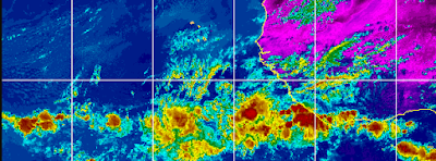
... one the bit of the blob off of Florida.
Secondly the wave off of Africa.

The reason I mention the bit of the blob is I'm not expecting anything to form but nasty weather has a way of popping up close in this year and taking everyone by surprise. Either way the rainy season has arrived in Miami and there is nasty weather hanging out offshore. And, early tropical waves depart Africa a bit too low to really develop as models implicate possible long range attempts at development. As always stay tuned!

Nothing is happening yet but.....
...the players are showing up on stage.

It's a process. 
I'll talk more on this tomorrow.


I thought this graphic was a good one to use.
Do you have a generator?
19% is pretty high I thought.
Perhaps that includes businesses?
Do you have water put away?
Access to vital financial information?
That's important.

Are you ready?
Good question.
Because it starts in 40 minutes!

As for me I'm in Miami as I type this and hours away from the beginning of the 2021 Hurricane Season. I'll be at a wedding Tuesday evening for my best friend's so ushering in the season together. Over the years we've chased severe weather and spend hurricanes together. Kind of a impressive way to start the hurricane season for me personally. I also have been visiting family that I have not seen in 18 months due to the pandemic so forgive me from being a bit missing in action from hurricane discussion building up to the official start of the season.

Will Miami get a visit from a hurricane this year? That's what everyone keeps asking me and I tell them what I tell you in that it is possible but not totally something you can predict. The reason I am concerned this year is that several of my closest forecasting friends have all drawn potential maps with Florida in the cross hairs this year. Florida does stick out into the Caribbean as if it's screaming "hit me with your best shot Mother Nature" and sometimes it gets hit and some times as with Hurricane Dorian it gets extremely lucky.

Get a plan. Put your financial matters in order or at least know who to contact when for what should a hurricane take aim at your town for landfall. Do you know the routes out of town and the best motels to stay in or the nearest hurricane shelter. Did you know some shelters make you pre-register and if you don't do so you may not have a space there when you need to evacuate. Now really is the time to get your act together versus panicking at the last minute and being stuck in traffic out of Florida finding yourself without gas or a place to stay. You may wish you can wish it away but you can't so the next best thing is knowing your options!

Either way I'll be blogging daily and I'll be on Twitter off and on all day. 

Besos BobbiStorm

@bobbistorm on Twitter and Instagram.

Twitter mostly weather and Instagram whatever.

With prayers that you and your loved ones get through hurricane season safely!


Wednesday, May 26, 2021

Tropical Atlantic Quite. 6 Days Til the Start of Hurricane Season. Lunar Eclipse and Thoughts on Vacations and Tropical Preparation!


To be honest there is nothing happening in the tropics.
Well, the Tropical Atlantic is quite.
In the EPAC there are two yellow circles.


Climate wise this is their time....
...usually you can count 10 days after they pop.
Will see. Models show possibilities long range...
...but not going there now.
For now it's all about getting your hurricane supplies.
I sound like a broken record but it's a popular song.
For now the EPAC has possibilities ....


Note African waves approaching South America...
...and ignite in the Pacific.
They skim the North coast of South America..
...and fire up in the EPAC.


To be honest.........  I woke up around 4:30 AM totally wired and unable to sleep. Nice hotel room, nice bed, pillows good... just wide awake after barely four hours sleep. I guess I can sleep tonight, but for now I'm wide awake. And, then I remembered the Lunar Eclipse and thought "wow.... those are some strong vibes there."  Griffith Park Observatory had a great live feed, but then a cloud obscured the moon and that messed things up.  I always loved Griffith Park Observatory, it was one of my favorite places to hang out when I lived in LA. There's a picture somewhere of me as a young mother in punky clothes and very high heels with some Joan Jett hairstyle enjoying the view from the top of the hill. 


The view of the lights at night is awesome.
The cloud hovers over LA hiding the eclipse.
Late night early morning low clouds and fog we call it.


So that's where I am today virtually.
Well not in LA but in Charlotte, North Carolina.
I traded California for Carolina.
Is that a numerology thing?
Okay I did Florida in between....
Going to Florida soon :)
First time in 18 months....

Totality is going on but no one can see it.
Back East the sun has risen.
Out in LA they are doing the best they can.
The view from the Magic Castle is also awesome.
I loved my LA days.


There's a picture from another site.
The Internet always has options.
As for the 2021 Hurricane Season...
...we have not really yet begun.


In the tropics options begin soon.
Still very early in the process.
Prepare it will be here before you know it.

Having a nice time here. I went to the Mall yesterday and bought a dress for a wedding in Miami, a best friend is marrying off one of her children. I brought two gowns with me but I may wear the cocktail dress with black high heels that I bought after I run it past my daughters in Miami who have excellent taste. Then I'll do what feels right. How do you make decisions? We went out to dinner with some nice folk last night, had a Vegetable Plate which is big down here in the South; there were freshly made onion rings involved so don't knock vegetables! I also had Coke with bourbon and relaxed after taking a swim in the pool, sunbathing for exactly 15 minutes because it was 90 degrees and I burn easy but rarely tan.... it just fades away. Trying to chill and relax and enjoy the quiet, because things will get hectic real soon and I do love the wild, unpredictable, often compelling drama of the Hurricane Season. I love studying them, learning new things and sometimes chasing hurricanes. I chase less these days than I did once upon a time but being in North Carolina there are plenty of options if I want to run down to the beach though it's not as tropical as it is in Florida with palm trees bent and well you're a whole lot closer to the tropics than you are up on Wrightsville Beach. That said, hurricanes happen on Cape May and Long Island and even New England and Canada but they seem more like powerful oceanic storms from the tropics than they do on landfall in Louisiana or Florida or perhaps that's what I'm used to... 

Have a good day. Make a hurricane plan, get a kit if you are lazy or busy on Amazon that fits your personal needs. Make a back up plan because if you live along the coast you may have to evacuate and if you live in Raleigh or Charlotte know that sometimes they can rip your pines apart faster than you can say "now what are we gonna do" and if you don't believe me Google "Hurricane Hugo Charlotte" or "Hurricane Fran Raleigh" and you will learn you may need to have a plan in case you another hurricane does that this year and Henri or Kate come to visit....  Could happen. Get a plan! Make a back up plan!


Sweet Tropical Dreams...
BobbiStorm
@bobbistorm on Twitter and Instagram


Ps. Mike and I have a joke about how we don't feel "there" on vacation until we put on TWC and see we are in that viewing area. Or the local weather and I'm telling you it's worth living in Charlotte to have Brad Panovich as your local weather person! So was fun watching his broadcast on air rather than on Instagram or Facebook.  Again, the Internet always has options. 


Yes, I generally enjoy my visits to Charlotte!
Nice city, huge and diverse.
Architecturally awesome.
Museums and Malls.
Much to do!

https://www.nascarhall.com/ NASCAR Museum is awesome, you can get lost in there for hours ... check it out if you come to Charlotte and NASCAR or cars is your thing; history galore on display everywhere. 


Enjoy the music....
...have a good day!


Monday, May 24, 2021

Tropics Quiet For Now... Fix Your Roof, Stock Up on Supplies... Hurricane Season is Dangerous.. 8 days away


Ana came and went....
..very briefly attaining the status of Tropical Storm.

Odd looking satellite imagery.


Good time in Florida to get your roof fixed FAST while it's dry.
Hot and humid in the South.
Double strands of long draping systems.. 
Eventually all that moisture near the Yucatan.....
.... sliding around in the Gulf of Mexico.
Could become a problem.

Climo wise it's a possibility.
Models come, models go.
Eventually the tropics really come alive.
And not talking about short lived Ana storms.

So stay tuned.
Get your roof fixed .. fast.
Stock up Hurricane Season begins in 8 days.
It's going to be a dangerous season...
...but for who?

More on that later.
Sweet Tropical Dreams, 

BobbiStorm
@bobbistorm on Twitter and Instagram


Saturday, May 22, 2021

Subtroical Storm Ana Formed in the Distant Atlantic. Next Name Up is Bill. Careful of Riptides at the Beach!


This was the satellite view from Thursday.
I tweeted this and it's true.

There are some hurricanes you chase and there are hurricanes that chase you ... and unless you're chasing the hurricane then you may need to evacuate or hunker down in a well prepared, safe place and pray. And then there are early season weak, odd looking systems that remind you the Hurricane Season is on it's way. 

Ana was not one to chase and thankfully not one to make anyone evacuate and its not a Hurricane but it did get the glory of using the name Ana as a Subtropical Storm, the first named storm of 2021. 

For the record the 2021 Hurricane Season I'm doing a short post on Subtropical Storm Ana that formed early Saturday Morning on the 22nd of May out in the distant Atlantic. It's a minimal system that the NHC upgraded and nothing really to write home about but hey this is a Tropical Weather Blog and so marking the event. Earlier it had a more defined circulation on some satellite imagery, I was offline today so this is a current picture 


Not going to show a cone.


Amazing when you turn the world around.
Love Earthnull.


Oh my gosh look at that system.
 Great Britain gets wild weather.

Next name up is Bill.

Currently the tropics are chaotic.
Best word I can use tonight.

What was in the Gulf of Mexico flowed into the Northern Gulf Coast... Texas, Louisiana with heavy rain, more flooding and a reminder that the hurricane season is 9 days away officially, even though Ana snuck in there thus providing a good reminder in the media that now is a good time to start preparing for Hurricane Season.  

It's very hot in the South so stay hydrated and if you get to the beach you may find riptides an issue so learn what you need to know should you get caught in one. It would be tragic for someone to lose their life in a riptide from strong winds along the coast but surf is up and riptides are ripping so please be careful!


Stay safe but have fun!

Sweet Tropical Dreams, 

BobbiStorm
@bobbistorm on Twitter and Instagram

Ps Do not think that all the named storms this year will be as wanting as Ana and as we get deeper into the season and real storms form and take aim at someone's coastline know the beat will have been turned around. So party hardy while you can and enjoy the music. 


Earthnull does show Ana.


Friday, May 21, 2021

Invest 90L & 91L - When Does Ana Form? What Will Texas Get A TD TS or Just More Rain .... Stay Tuned. Developing Tropical News Day


Today is kind of a work in progress post here as we are watching Invest 90L look more and more as if it will get the name Ana. Systems such as this have a brief window for that sort of development out in the open Atlantic on the other side of Bermuda but many take advantage of it and do get a name. Pulled together tremendously since yesterday at this time. NHC indicates in their discussion that it could likely get a name later today or tonight. Models take it away from the US and Bermuda so it's more a marker of the start of the season and an issue for ships at sea. 


As for Invest 91L it's headed towards landfall.

Models are direct and predictable.


As for 91L that in theory could become a Tropical Depression or Bill briefly before landfall it's important to remember the real threat here is the threat of continued tropical moisture raining down on an area already used to having daily flood warnings.  Parts of Florida and the Carolinas would kill for this sort of rain and they probably should be careful what they wish for ... but parts of Texas and Louisiana are already inundated. Further upstream in the farmlands looking for rain they will be happy to get whatever they get from Invest 91L. 


This is a true tropical transport.
Moisture being sucked North.
And that's good because.......
...it has little time to really develop.

I'm curiously watching areas of moisture down near the Yucatan that have been flaring up and firing off and flaring up again.  Just something that catches my eye and distracts me from the poorly defined but developing Invest 91L. One of the best sources of information with a system such as this is the local NWS and the one in Houston is one of the best.  Note the base of that arrow extends down near the Yucatan, just saying.   Whatever happens with 91L know that there is more coming up from down below and at some point we will be talking hurricanes not marginal tropical depressions or storms.


As always follow NWS New Orleans this time of year!

Stay tuned!
Huge drama...
Is Ana in the Atlantic?
Or could 91L steal that name?

We should know the answer soon!

I'll update later today I'm sure.
Besos BobbiStorm
@bobbistorm on Twitter and Instagram

Ps Extra Credit 
Seriously bugs me the Wave Train is so busy.
Non stop despite Saharan Dust.
Note this one tries to punch up into the SAL.
That is not normal for late May.
Prepare now for Hurricane Season 2021
This more than 90L and 91L should make you!


Think Hurricane Preparation......
..as for who gets what name.
The answer is blowing in the wind.


Thursday, May 20, 2021

UPDATED! INVEST 91L in the GOM Joins Invest 90L in the Atlantic 90% Chance in 5 Days ... Subtropical Storm Ana? What's up in the GOM? Just Clouds and Convection or Maybe Something More Down the Tropical Road?


9 PM update.

Invest 90L is now at 90% chances.


Invest 91L in the GOM popped up close in...

I spoke on this today many times...

... if anything forms it's forecast to move fast.

Stay tuned to see if the NHC upgrades 90L soon.

It's not always about the models, they show something and then they take it away often and then they spit it back out like bad sushi.  You look at the satellite, you know the flow and you know Climo.  The saving grace is the fast flow in the Gulf of Mexico so should this develop into something organized it will be a fast mover.  Out in the Atlantic 90L is trying hard to give birth to our first subtropical storm ANA or Tropical Depression. It better push hard or our homegrown circle could steal that honor of the first designated system of the 2021 Hurricane Season.  Please keep reading my thoughts from earlier today on this set up. And, I'm still thinking another system could develop in the Gulf of Mexico given time; both the Gulf of Mexico and the waters off the SE coast are favorable areas for development in June and late May. As the NHC says "regardless of development" this will add to the wet misery that Texas is already dealing with making a bad situation worse.


* * * 

9 AM

 Invest 90L in the Atlantic.


You can use the link below to watch in real time.
It's developing in it's own odd way.
Subtropicals are often messy.

https://www.nrlmry.navy.mil/tc-bin/tc_home2.cgi?SIZE=thumb&AGE=Latest&ARCHIVE=all&MO=MAY&YEAR=2021&STYLE=frames 

Currently it remind me of watching a chef fold egg whites into a batter to make a fancy complicated desert as it's not spinning but folding, cranking up into something that most like will be Subtropical Storm Ana if it gets a name. NHC raised it's chances to 70% in the 2 day and 90% in the 5 day; they seem pretty sure of it's eventual formation so it may become Ana in a few days off the East Coast out at sea.


This is not a neat system.
It's messy and all over the place.


The NHC seems sure tho it will attain a name.


My thoughts below.

It's obvious that the 2021 Hurricane Season is a continuation of the 2020 Hurricane Season when it comes to a naming frenzy by the NHC and you know that is THEIR call as they make the call. Different administrations there had different parameters for using a name or upgrading to a designated storm. Some were exceedingly slow to upgrade and it drove me crazy, others were faster to upgrade to named status and that's the way it is... it's their call and if this becomes upgraded it will be Ana a name often used for similar systems.  In 2015 though another Ana became an early May Tropical Storm when it formed also off the East coast and so it's worth noting no matter who is in charge nor what the conditions are there really is nothing new under the sun... or near the sun or...however that saying goes.

https://en.wikipedia.org/wiki/Tropical_Storm_Ana_(2015) 


This is what might be Ana below now.

Not there yet but it's working hard for the money.


The one commonality is the location.

And that is what CLIMO is about.

Another area I'm watching is in the BOC.


Just convection for now.
Convection as in RAIN and Clouds.

Last week I knew it was more likely that the Atlantic system could form into a subtropical vs the storm the models were cooking up for the Gulf of Mexico. BUT when you have a huge high pressure dome with heavy hot air to the North of the Gulf of Mexico if there is any lessening of wind shear or let's say the flow relaxes it's likely that something could try to form and it needs to be watched. The modeled storm seemed more likely for the end of May than this week but we have to wait and see in real time.


What grabs your eye? The X that is NOT where the area that looks like the Low but know it is forecast to move towards the West as per NHC discussion or the area of convection in the GOM or the ghost of the last front to move down past Florida ?? 

Stay tuned.
2021 Hurricane Season will be interesting, busy and sadly at some point for someone somewhere deadly so don't get blase because the first storm of the season may form out in the middle of nowhere. We can't always get what we wish for but we do need to prepare for what we don't wish for...

Now is the time.

With wood supplies low and gas lines and prices crazy it's important to take that into consideration. Hoping that this will NOT be a factor come August and September but the 2020s have shown us you can't rely on anything to be normal so remember that and prepare now as best as you can. Again if you pick up one item every time you run into the Dollar Store (just one) you will have quite a stash of hurricane supplies in a month's time. 

I'll update if and when the NHC does again later today with Invest 90.

Besos BobbiStorm
@bobbistorm on Twitter and Instagram


Wednesday, May 19, 2021

30% Yellow Circle in the Atlantic. WAVE TRAIN Early But Active Off of Africa. Tropical Moisture Feed in GOM Into Texas & Louisiana.


 Two things to talk about briefly this morning, just to touch base on the tropics today. There is a 30% yellow circle in the Atlantic that is the area I mentioned last week that long term models had been showing as a possible subtropical sort of Low. This region off the East Coast often produces "subtropical" storms early in the season .... and even more often yellow circles and Invests that do not develop. It's not of a tropical nature but it takes up a large part of the watery real estate in the Atlantic. Also notice that the high for now holds strongly in place over the Southeast and the adjacent Gulf of Mexico.


Note the image I posted last week ...


While I was less sure on the GOM possibility.
The Atlantic 'low" of some kind seemed plausible.
That brings us to where we are today.

Again the high pressure clamped down over the Southeast and the Gulf of Mexico, however the low pressure the models had been pointing to is trying to form. Again we are not talking tropical but it's something to monitor.

Link to that blog shown above is below. It was from May 14th. 
This time of year you monitor stalled out fronts and areas that remain over time such as the area of convection near Texas/Louisiana currently and areas of non tropical spin in the open waters of the Atlantic.


Again the tropical moisture flow is ON... 


Moisture from the Gulf of Mexico is being fed from the Caribbean and you can make out the remnants of the old front. To the Southeast...bottom right corner you can see how strong that one wave is in the ITCZ as we used to call it back when... it's a convergence zone. If that wave that shows up bright pink in the orange was further to the North and this was late June we'd be talking names. But for now it's a wave train and it's impressive.... note it continues into the Eastern Pacific. Saharan Dust is currently taking up residence where waves form later in the season... but it's not impossible for a strong tropical wave to come alive after longitude 55 West especially if it climbs. It would be really, really rare but since it's the 2020s I"m pointing it out. 

I'll update as needed.
You know the drill... Hurricane Season is officially 13 days away and the NHC is already issuing Tropical Weather Updates and there is a yellow circle in the Atlantic so do not let an early start to the 2021 Hurricane Season take you by surprise. Invest in inexpensive supplies now before things get even more expensive than they already are.... and hopefully this gas mess will resolve before anyone has to think on evacuating and driving out of town on an expressway at a time when gas is hard to find. One problem at a time for now and your priority now is making a plan, a back up plan and stocking up on hurricane supplies.

Besos BobbiStorm
@bobbistorm on Twitter and Instagram


What we don't usually monitor is African Wave Trains. That's a Noun in this case though it's a noun in action moving westbound in cycles. Tropical Waves are sort of like mini systems within an overall area of deep convection. But they are cells of self contained moisture that on occasion do produce low pressure and can develop though........ really rare to have that happen in May let alone June. But, since the 2020s have been so random weather wise we are going to monitor them.  They are too low to develop into anything as waves need to climb up above 7 North closer to 10 to really get there spin going, but seeing a whole bevy of early contenders is a bit unnerving. 


Sunday, May 16, 2021

Tropics Quiet While Models Often Chase False Echos - EPAC Convecting While Heat Ridge (Double Barrel High.... ) Sets Up Across the South.


Really only game in town is in the EPAC and the NHC doesn't seem interested. Lots of tangerine colored convection on satellite imagery consolidated in little balls firing off of South America every few days.  In the Atlantic side of the Basin that includes the Gulf of Mexico nothing is expected to form any time soon. But models are sniffing out tropical moisture as a feed of tropical moisture is being funneled into Louisiana and Texas. Miami is on the edge of May Monsoons that will begin soon (the current rain is pre-season rain) and you will know when it happens as the media will remind you Miami is flooding (for a few hours til it runs back off into the bay) and Miami people will post dark pictures of impending doom like clouds on Twitter.

I'm not the biggest fan of the song Fins but to quote that song... EPAC is the only game in town today and NHC doesn't seem to be attending that convection fest so I'm just pointing out it is primed and beautiful if you love convection on the satellite imagery vs Saharan Dust shadows in the Main Development Region. I capitalized that for newbies because it is otherwise known as the MDR.

The GFS took a step back from the ledge today and must have taken the day off so check back on later models to see if it tries to reform something in the GOM. Time will tell. The NHC can start their tropical updates in Mid May if they want (totally okay with me... I love illusions) but that doesn't mean anything will form early this year. And, Climo would say to watch the area off the East Coast that isn't as interesting nor does it make for great click bait.  Generally IF the Epac produces something the Atlantic side goes quiet for a week or so as they seem to take turns ... especially in the early preseason days of the Hurricane Season.


That's a lot of Highs... 
Double barreled!
Hot! Hot! Hot!

In truth a huge ridge of high pressure and horribly hot weather is set to build in across the Deep South reminding us what our summers are like and often when you have such a ridge build in low pressures can build to the South and we are desperately searching the models for a good cold front to kick it out but we are getting closer to June than to May.


Strawberry or Blueberry topping?
Caramel or Chocolate or both?

I'll be offline for 2 days for the Jewish holiday of Shavous when we celebrate the giving of the Torah on Mt. Sinai on our way back towards Israel over 3,000 years ago after being slaves in Egypt and the synagogues in America will be serving up cheesecake and ice cream and you can Google why if you are interested but it's a dairy feast of epic proportions. If anyone has problems with dairy but they love dairy they will be double dosing on Tagamet for the feast!  I'll be starting back on my regular Paleo diet after the holiday :) 

Til then Mike is deliciously rambling on weather, tropics and anything that pops into his head on Facebook Live. Dabuh is playing musical messages while watching both the waves in the Atlantic and those coming in close to shore where he surfs and does this thing.  Most of us are quiet. I did see iCyclone wax poetic on Facebook (he's better on Facebook by the way... he goes long there) and so keep watching the NHC to see what they say but the real question is does Mother Nature play a funny prank by being quiet until June 1st after they jumped the gun on May 15th? Only time will tell. That's another Jimmy Buffet song... So many Jimmy Buffet songs rolling around in my head..   

Besos BobbiStorm

@bobbistorm on Twitter and Instagram.


Ps... yeah sad song but great lyrics.
Jimmy is a poet and he knows it.

Bit bored, just wanna have some fun....


Friday, May 14, 2021

Will Something Develop in the Tropics Next Week? Gulf of Mexico Is a Possibility ... and Worth Watching the Bahamas Later in May.


This is the tropics Friday.
There is no named storm.
BUT models are producing one... 
...but not all models are on board!
A front is draped across Florida.
Dark red convection in the EPAC.
A wave moving West across the Atlantic!


Let's take a look close up.
This is the issue here. 
A stalled out front across Florida.
No real steering currents currently!
Never a good set up early in the season.

Usually nothing happens or there is some development in the Bahamas or in the Eastern Gulf of Mexico. The GFS, but not the Euro currently, is forecast to close off a Low and move it North towards Louisiana. Not sure really what to say as it's going to evolve in real time. Other models were looking at the East Coast near the Bahamas. May development is rarely a locked in set up until it actually begins to develop.

So let's look at that model below.
This would be next week on Saturday.
Yes it looks like 2020 all over again.
Today Louisiana bound.
Sunday it could be Mobile Bay.. 

d
But after landfall as maybe a TS look what happens.
A Large Low is off the East Coast on Thursday 5/27.


Then check this out......
...after it goes away another one is there. May 27th!

The set up is there and it's the time of year but I can't say for sure what will happen, Just be aware it is that time of year and we have a decaying front that stays so long it might be looking to rent a vacation home. Seriously long time readers know that I wax poetically on dead, decayed fronts stuck over the warm waters off the Gulf of Mexico (or Bahamas) as prime time tropical prospects especially in May and June.

Why the GFS is finding  multiple lows in the not so distant future... I can't say. Early on models do that. Ever have a relative (or maybe you do this) that take a stick and show it to their pooch and then make big arm movements as if they are a pitcher in the Major Leagues and pretend to throw the stick far off into the field and the pooch races off after the stick he thinks they threw but alas he's still holding onto it laughing.  That prankster is basically often what the models do this time of year. But, if the set up wasn't there currently it would be easy to write off the possibility. 


Again this is the set up.
Stationary front over warm water not moving.


June climo shows it's where we always look.

And that's why everyone is talking about it...
...online but for now it's talk.
But definitely it is possible.


Note it's not just Dabuh....


So check back Saturday Night for more thoughts.
Time will tell.

Saturday the NHC begins officially posting...
...  a Tropical Weather Update
Hurricane Season starts in 2 weeks!

I do expect something official to be watched.
An Invest?
A tropical depression?
Subtropical?
Something... that it possible.

Either way the EPAC is going to ignite again soon.

Stay tuned.

Besos BobbiStorm
@bobbistorm on Twitter and Instagram