Hurricane Harbor

A writer and a tropical muse. A funky Lubavitcher who enjoys watching the weather, hurricanes, listening to music while enjoying life with a sense of humor and trying to make sense of it all!

Thursday, September 30, 2021

Hurricane Sam and Victor! October Tomorrow... What Will October Bring to the Hurricane Season?
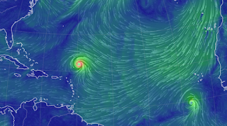
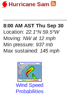
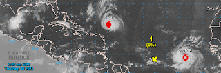


Hurricane Sam.
TS Victor.


Check out those wind profiles!

There futures are tied together like bread and butter or peanut butter and jam. Wherever Sam goes, Victor wants to follow. Not much I can really say, other than - - thank you Sam for sparing the East Coast. Sweet of you, hopefully the rest of the named storms will follow your lead. But, deeper into October trouble could be brewing and it will be harder though not impossible for this pattern of avoidance of the East Coast to continue.  

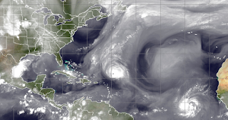
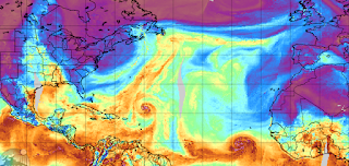
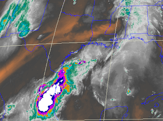
The most obvious feature on the map above doesn't have any kind of circle. The mass of convection off the coast of Texas is interesting in that it "looks" like a landfalling system that formed over land and is about to exit over into the water; radar shows it's very active. Again tropical moisture will always find it's way up into the heart land and over tropical waters even if there is no circle and no name and no model producing any named storm. And, yet it will produce weather as the image on the  MIMIC below, shows how much moisture there is down there moving and oozing around. That's an abundant, tropical flow that is flowing way up into Canada without a named storm creating this anomaly. Lastly, look at that horizontal feature out ahead of Victor - that is strange. It actually has a name and it's Invest 91L. Currently the NHC is very down on an idea of development, though models do show some signs of life.


Note the little yellow X below. NHC says "No!"


Models shown below because why not?


Keep that in the back of your mind.
Don't worry on it but remember it.

Part of that energy could get into the Caribbean down the road and try to brew up into something. This is how "pop up" surprise systems get going, they take a piece of old energy and wait for it to do something. Think of it like Sourdough Starter! 


And, while this is not being watched and doesn't have any real signature other than rain, it's going to rain on someone's day today and the associated moisture will keep on moving up into the heartland. But, then fronts will keep dipping down (even dry fronts) and there will be this battle going on between the moisture from the tropics and the fronts from the North. That's the show, that's the drama as we move into October tomorrow and then into November down the tropical road and November is that month when anything goes. Then it's all over and that's the real reason the early settlers gave thanks in late November ;) 


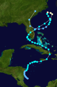
Hurricane Gordon, a November mess.
Dissapated just in time for Turkey Day!

Sweet Tropical Dreams,
BobbiStorm 
@bobbistorm on Twitter and Instagram
Twitter usually weather...
...Instagram whatever!

Ps Using the lyrics version so that you can learn the lyrics... if you don't know them. Wild storm last night here in the middle of the night, two hours before it was forecast to "sprinkle a bit and barely make it down to the surface" and that's a gentle reminder that meteorology is not a perfect science, it's a science we are constantly learning more about as time goes by but that's another song.


Monday, September 27, 2021

Hurricane Sam Following the Plan ...Staying Away from the East Coast So Far. 2 80% Red Circles Behind Him. Memories and Looking Forward Highlighted Today... October is in the Wind.


I like to use different images of the cone for Sam.
This one kind of says it all!

Not much to add on Sam other than the research team flying into Sam has obtained lots of data they are using now to forecast as well as possibly make forecasts better in the future. That's really the goal here is research to learn more and more about all the things we don't know -  - especially regarding rapid intensification. 


This image above shows the fact that fronts are forecast to get all the way down into Florida, and I mean all the way down as in West Palm Beach may even seen cooler temperatures fora  few hours, maybe even Miami. This is early for a first front to get through down there, trust me I know as we would pray three times a day for a cold front to show up already when we were kids. One reason for that often was we got wild storms when the line came through and the change (even if only for one night) was awesome.  The wind blows when a cold front pushes through South Florida. 


That brings us to my next point I want to make that I have been pushing for days. We are about to go thorugh that change from September to October. Note the two images above and you see the sudden rearrangement of alignment of possible hurricane tracks. Usually what happens this time of year is that waves off of Africa that get red circles sometimes stay low and make it across into the Caribbean, where they wait for the next cold front to drop down (if there is a front and this year we seem to have fronts) and catch a ride up the front into the SE as you see above. 


If either of these 80% chance red circles stay low and get into the Caribbean, missing the detour into the Atlantic that Sam took being a September storm, then we get an October possible storm developing. Most long range models show pressures lowering and climo wise that could happen and add in low waves headed into the Caribbean you get an October storm pattern.  I know you are thinking but we are running out of names, okay many of you know how this goes, but yes we are mostly due to a large amount of "shortie" storms that formed fast and left just as fast. October storms generally are not "shortie" storms but long, lived "hang around" storms that cause misery there and up our way.


Mike made a graphic. He is good at that.
Always loved the name Caridad. 
Caridad in the Caribbean?
Who knows... time will tell.

If anything happens later today I'll update the blog. Give thanks that Sam stayed away I suppose, beautiful to watch from far away and so give thanks and enjoy what's left of September. I'll be offline Tuesday and Wednesday for a holiday called Simchas Torah which can be a lot of fun. It was especially fun in Miami in the 1990s... I will say that! Some of the best/funniest, most endearing memories of my life. I'll try to find some good memories this year and I'm happy it's cooled off up here and that means the leaves will begin to turn and we will be knee deep in Fall Foilage Fun! Yes, all capitals.

Wilma was our Simchas Torah storm in Miami, though have to admit it came afterwards when we had no electric and everyone walked to Temple with flashlights, light sticks and partied under a chandileir filled with hanging flashlights and light sticks because one way or the other even a week later the party must go on. A memory where we overcame lack of electric, AC.... etc and life went on somewhat differnet but it went on and well growing up in Hurricane Country we learn to adept in whatever way we need while we slowly get back to normal. 


Funny note here at the end, Mike is talking on his Facebook Live and complaining about someone who was bothering him nonstop and complaining about far out models that show us possibilities. Um, this is what people want to know. People know the different between "this could happen" "this might happen" "it might not happen" but want to know "what might be happening" because that's why you are here, knowledge is power.  And, as he said it's "HIS PAGE" he shouldn't be told what to post, if you don't like it go to someone else's page. Then someone bitched to ABC Liquor Store that supports his page and complained they shouldn't support someone who drinks. I mean you can't make this stuff up. 

But that was why I started my blog years ago. I was on a gazillion message boards, after Weather Chats rearranged my life and evolved into "Message Boards" and the message board on HurricaneCity was filled with feuding over what you could or could not post. So I thought... "blogs" umnnn well I write, I journal, maybe I should start a blog. And, that's how this blog became, more a place to rant, be silly, write fun stuff and hopefully educate people about what was happening or might be happening in the tropics during the Hurricane Season. Off season back then was usually way off topic from weather but very few people read it then and I often changed the names to protect the not so innocent.

As for Mike, yes listening to him ramble on and on about NASCAR (forever) and complain about the person complaining about him and talking about long range models. I feel at times like I've grown up with Mike and we must have done this in Elementary School pissing off the teacher as we whispered about a possible hurricane coming. But, no we met online where we all had our second childhood talking about how much we love weather.

If you are here.... you must love weather too!

Check back Wednesday night when I will update the blog. Til then pay attention to Mike as he talks tropics though he'll be away at Talladega (sounds like so much fun) and before you blink it will be October! 

Sweet Tropical Dreams,
BobbiStorm
@bobbistorm on Twitter and Instagram


Sunday, September 26, 2021

Sam 145 MPH Eyes an Approaching Cold Front to Travel With... Not an All Clear But Looking Good Today Re: Sam. Down the Road Watch Out! October Surprise Coming!


There should be a Country Song about trofs and hurricanes in September; you know a strong cold front walked into a bar and everyone looked up and took note of that handsome cowboy! September Hurricane tracks are always decided by how strong the cold fronts are and if they are even there. A cold front always beats a hurricane; even a somewhat small, but beautiful Category 4 hurricane. But, in truth all they are doing is assisting the hurricane that wishes to go North to begin with and so no one loves a good cold front more than a hurricane.

It's the law of attraction, opposites and yet they have so much in common. Lows go to lows and they will run off with lows faster than they can say "May I buy you drink Sam??" 


145 MPH! 

That said it seems to be "up, up and away" for Sam as he travels in the wake of Teresa, Odette and the others that took the kinder path like Larry as opposed to Ida. There is the smallest chance something else could happen, but that's why we track them as opposed to saying "nothing to see here, go back to golfing!" 

But we all watch it, stare at it and think "wow" whether we are older or younger, weather has no age boundaries if you have that weather gene in your body and soul.  "look at that eye!!!


Dark core, solid eye wall with lightning striking.
Bit narrow dry line there on the SW side... 

Bermuda might need to watch more than Barbuda!


Whether you're watching weather on a laptop....
...or from the inside of a Recon Plane.
"Wow!"

Elsewhere the NHC is monitoring several areas, though none seem to be popping any time soon so going to enjoy my Sunday and get on with the process of life in Raleigh where most of my clothes are in the closet; I always have clothes at my daughter's in Miami and if not enough I can wear what she's wearing :) 

I cannot repeat this enough so let's try one more time. As hurricanes approaching from the ESE get a free ride out of the tropics on the wings of cold fronts. Those same strong cold fronts will attract traveling buddies from the South should there be a strong Cat 4 down in the Caribbean somewhere. So don't start slapping yourself on the back thinking we are "home free this hurricane season" because you ain't. Plain and simple in fancy scientific lingo or plain old folks lingo we are far from home free.  

October is the month that brought you Wilma, Sandy, Hilda, Hazel and the list goes on and on. And, after doing their intensification dance they looked up to the North or NorthWest and smiled and thought "wow, that's a damn fine lookin' cold front up there!!" and away they went making landfall as strong, violent hurricanes just two weeks after you decided to eat all your Twinkies and drink up all the water you were saving for hurricane season. Don't be that person! 

Enjoy the weekend! It's a gift from Mother Nature who is saving up something spectacular to knock your socks off that may show up in the next week to ten days so party hardy today but do not touch the hurricane supplies! Do not gamble with the money you need to escape a hurricane or you need to restock your hurricane supplies because it ain't over... you got to know when you use them and when to hold them!

Besos BobbiStorm
@bobbistorm on Twitter and Instagram
Twitter usually weather and Instagram ...whatever.


Friday, September 24, 2021

Subtropical Storm Teresa Joins Hurricane Sam in the Atlantic Basin. Sam Still Far Away and Much Can Change. Stay Tuned.


So that happened today! Subtropical Teresa formed rather suddenly and is forecast to be short lived. The NHC forecast is for a quickie sort of hook movement and there are no cities in the Wind Probs. It could help to weaken that edge of the High which may or may not be a factor down the line. It should be short lived but around longer than dinner so from barely anything to look at to getting the Teresa name means the next name up is Victor!


What's a Subtropical?
Phil Ferro explains it clearly here.


Back to Sam.


Looking good, stronger.
Getting closer to the Islands.
Though the Cone doesn't touch them currently.


Sam as I said previously is a bit of a trickster. Everytime you expect it to go slow it speeds up and when it looks to be taking a break in intensification it intensifies. A sort of stairstep crooked development but smoothed out it's fairly consistent. Currently the peak of intensity in the 5 day is for it to be 140 MPH in 2 days. You can use that as a measure to how on the money the forecast has been with regard to intensification. Generally we are better at track and still trying to perfect intensity forecasting.

While the cone is barely at the Islands, many of the islands are in the Wind Probs though they are still very low. It's a good measure to watch how they change as an indication of future changes in track. This is how I use it, based on how someone who worked at the NHC years ago who was a close friend/neighbor suggested I use it and it's never really failed me. 


This is where the wind probs come in, as they are shown on the NRL track map that I use frequently. As always watch the trends with regard to future forecasts. It's worth saying that the best thing you can do with regard to Sam is to stay prepared and on top such things as having your medications refilled in case a hurricane does come to visit you. The NHC forecast is carefully prepared and though there are many intangibles as every day passes it becomes more clear what will happen. There are errant models that show parts of our coastline in danger and most of the others insist it will stay out to sea. Too soon to tell, follow your local experts and check back here Saturday night. 

For Miami people, please follow Phil Ferro he's very good at what he does without hype nor ego.
Forward speed will be a key as will factors out ahead of Sam. Remember there is an area behind Sam that could become Victor, unless something forms faster in the Caribbean - however that's more down the line rather than coming soon to a theater near you!


Again any time there is a hurricane forecast to become a stronger hurricane out in the Atlantic to the ESE of you ..... monitor any changes in the forecast, remember it's there and continue to make sure your hurricane prep plans are set to put into motion should the cone begin to inch closer to your home!.

Sweet Tropical Dreams,
BobbiStorm
@bobbistorm on Twitter and Instagram

In NC watching the blue skies and loving the cooler temperatures. No one is praying for the next front to be a strong one more than me. Love winter as much as I love tropical weather. As for the rest of the world, my eyes are also watching the volcano put on it's show. I studied much geology along with meteorology in college and well I'm kind of an Earth Science Lover. 

I really prefer hurricanes to most other forms of "natural disasters" but in a strange way watching volcanoes is similar, but different, to watching the beauty of the Northern Lights. So much color and intensity, unpredictable and potentially destructive. 


Afternoon Update. Lots Going On... Is Teresa Forming Now? Invest 99L 70% in 2 Days. Hurricane Sam. Westbound 15 MPH ... Can Intensify Fast & Collapse as Fast. Some Dry Air Out There ... MDR Unusually Dry in Late September. Still Far Away.


The wave off Africa is at 50% in the 5 day.

Ex Peter or Invest 99L is at 70% Red in the 2 day.


Invest 99L Models below.


So how does this figure into the long term picture with regard to Sam? Possibly a lot of different ways as it could interact with a trough. Another intangible is how strong is that trough? How do they interact? Or does this new system weaken up the edge of the High and allow Sam to follow along as if a was a plan all along? Some models imply it actually is involved in coastal mayhem and then after putting it's left foot in it takes it's left foot out and well you get the idea.  It's not merely a "fork in the road" but a 5 point stop in ways and the models will try their best to figure it out as if it's a Sherlock Holmes mystery novel in the works. 

As for Sam, he's cruising along Westish faster now than he was forecast to go. The NHC had mildly adjusted his forecast forward speed back to very slow from slow movement. And, then Sam sped up a bit. Sam has "trickster" all over him and until this all plays out in real time it's too soon to buy into any possible end game. We will know soon enough, but until Sam is swimming with the fishes we watch him and monitor any changes in his intensity and direction of forward speed.

Also something will begin to try and develop in the Caribbean as I have said like a broken record. We are in that in between time and the tropics are curerntly acting more like October than Prime Time September. SAL is there waiting to go BOO even though it's a ghost of what it was earlier in the season. Fronts are on the move yet not reliable, but there enough to call out to anything in the Caribbean to come and play a bit. And, they are not a force to reckon with yet that we can simply say any approaching hurricane from the Atlantic will be picked up and swept out to sea. It's also a time when close in, homegrown systems can pop up and be a problem or maybe just a steering factor for the star of the show. 

Think on that. The 5 PM will be out soon. But in truth, they will most likely extrapolate the current forecast with some minor adjustments and move the cone a little bit further down the line.

You know that old saying "too many cooks in the kitchen" well add in sneaky cooks in stealth mode that the other cooks who are cooking fast do not notice. Remember the epic video of the basketball game where you are asked to watch which way the ball is going? It's a classic example of how what you focus on or want to see is sometimes only what you see.

https://www.youtube.com/watch?v=IGQmdoK_ZfY  

Teresa, if she forms from 99L, is that one you didn't see coming while staring at floater loops of Sam. They definitely are from the same family. Pranksters, playful and filled with surprises.

So which one is Teresa? 

Isn't Victor such an incredible name? I think so.


Looks like a storm is developing in the Atlantic ...
...off the Carolinas coast. 
At the least. Same doing this thing waiting his turn.


I'll update later with any new information. Compare and contrast the 3 PM Earthnull with the one from earlier this morning below. 

***


Sam, still far out from the Islands.
Moving slowly 15 MPH West.
Hurricane Sam that is this morning. 75 MPH.


Models currently, mostly, curve him up before the Islands. Still nothing set in stone. Small storms are problematic as they are more likely to intensify up in intensity fast, and collapse just as fast. It's making good use of it's moisture as the feed visible on the Mimic loop is enough but not abundant for the MDR this time of year.  The MIMI also shows the cold front that has brought my temperatures and dew points down in the Carolinas moving very slowly waiting for reinforcements to kick it out. 


If you clicked on that link above you will see the dark blue colorful high pushing down on Sam at the top right of the image above. Shows you why Sam is Westbound for now. Also note "the front" across the East Coast seems to have halted progress but another one should kick it out as I said. 


A nice view of the cone from Hurricane City.


A few things not to forget. There are several areas being watched in the Atlantic, a wave behind Sam could become Teresa unless one of the closer in remnants of previous storms mingled with other moisture become surprise pop ups. No real surprises today and unless you live in the Virgin Islands it's a long, long ways away. Bermuda may end up watching this very closely. Time will tell.

I have an appointment this morning so I'll update this after with any relevant model information or intensity changes.

Cooler weather in the Carolinas today and I'm loving it. Blue skies and cool enough to take my new hoodie to a friends house as the walk back should be in the low 60s. It's cute I need a good excuse to try it out. Stay safe, stay prepared and remember as we move into October soon enough it's the area we really need to watch.  While 2020 may have seemed the longest year in recent history, 2021 has zoomed along faster than a speeding train. 

Besos BobbiStorm
@bobbistorm on Twitter and Instagram

Ps Dedicated to Bermuda wondering which way Sam goes... not to say everyone in the Florida Keys are watching quietly, because when there's a hurricane out there you remember it while enjoying life.


The MIMIC really tells the story today. Dry air (for the MDR) as SAL is still a factor. Sam moving a bit faster than expected, though NHC slowed the speed forecast down a tad and now it's cruising along. Hope you watched the MIMIC really as it tells the story. The NHC discussion basically says the cone is between the EURO on the right and the GFS on the left, as I said yesterday. Not much has changed other than the NHC crowning him with the Hurricane title. Still expected to be a Major Hurricane.


Thursday, September 23, 2021

Updated 5 PM. Tropical Storm Sam Forms! Forecast to be a Major Hurricane Approaching the Islands. East Coast, Bermuda and the Islands Watching to See What Changes IF Any Pop Up to Change the Long Range Destination of SAM..


Cone at 5 PM - 60 MPH
Again slow movement for now.
Major Hurricane forecast.
Also WEST..... not WNW.

Earlier in the blog below I mentioned that if they say 115 MPH expect it to be higher. Six hours later and they are now showing 125 MPH so again I'll add it could realistically be stronger than 125 in 5 days.  There is just too much going on currently as it is still organizing, down the distant road past the five day period it's still too early to say what will or won't happen. But this is one to watch as it will be a strong hurricane by current forecasts. The blog below mentions the various points that are factored in so please keep reading. But in truth much evolves in real time so a forecast for a strong front today could be a slow, weaker front 4 days from now. The High is still trying to get itself back into shape after Larry, Peter and Rose and oh Odette so what it will exactly look like in 7 days is the big question. Much to factor in and again remember to make sure your hurricane supplies and such are up to date including having enough medication; power outages are not the only problems people deal with in the real world after a landfalling hurricane shows up at your door.  

And... soon the Caribbean will come alive as it does in October and we always have unfortunately October Surprises in the tropics in busy years so keep on top of what you need especially if you live in Florida as it's favored in October for all sorts of landfalls from weak storms to strong ones!

Below is an image of the earthnull signature.
It's there but not as strong as it will be down the road.


A lot of discussion on the inner core of Sam on the left.
Still developing ... a work in progress.


Please keep reading if you did not do so!

Thanks!

* * * 


This is Tropical Storm Sam.


Ironic that all 3 systems marked are in vertical line.

It's a weak signal of sorts but it has nice form and the NHC has decided for a myriad of reasons that you can read in their well written discussion that TD 18 is now Tropical Storm Sam! So, that said, we need to watch this storm and see if forecasts verify and models do not change from what they are currently. It's far out in the Atlantic and quite far South currently moving slowly under a developing strong high. Note we are in a period of flux, where a new Atlantic set up is taking place after the various small tropical storms Peter and Rose took a bit out of it's strength. 

How strong will it be when Sam gets to the Islands? How low will Sam be?

How and where will the cold fronts be and how strong will they be?

What changes occur in the forecast patterns between now and a week from now?

These are your typical late September questions that arise when we have a long tracking, tropical system moving WNW around the High Pressure with everyone from the Islands to Florida up to New England watching; never forget Bermuda that is always watching carefully. Note how slow Sam moves at some point as it is (in theory) consolidating his strength to the point on the 4th and 5th day that the NHC has it as a Major Hurricane. But, will it be a Major at the top part of the cone as we see the cone today or the bottom part of the cone and how will the cone change over the next 5 days. The bottom part of the cone would take it into the Islands or give them one heck of a brush with danger. The top part would imply it's going out to sea. Then there is the High that is forecast to dig in and where ever the high begins to weaken is where Sam will make his break more to the North as all hurricanes do as they are programmed to do by nature. Again Highs will always block their progress to the North, cold fronts approaching the coastline and the hurricane will grab the hurricane and help it move more to the North as well and hopefully out to sea.


Today we see a front across the East Coast, our much awaited first strong cold front of Fall and the remnants Peter where he ran out of gas and you can see where his remnants will go. We are days away, a week away from knowing what will be for sure when Sam is eyeing the East Coast longingly wanting to visit before moving away out to sea.


This wonderful image from Zoom Earth allows us to see both Sam and the rest of his friends. The remnants of Peter that were removed from the map way faster than Nicholas was and Rose far out at sea to the North of Sam. You can see the cold front draped across the East Coast and you can see Sam's Cone as it stands now with the latter dots brightly colored showing he is forecast to be a Major Hurricane at the end of the 5 day Cone.

When is I say the cone will change I only mean cones change frequently in little bits, extrapolated over time to make a big difference in the way that Nicholas was supposed to be a Mexican storm before they kept edging it to the right so that it was a Texas storm. The 3 day should be perfect, the 5 day is good but beyond that changes usually occur. 

I'll add models that I am NOT going to show this morning show some odd things happening in day 7, 8 and 9 including some small Imelda type system shoot off West away from Sam. If you remember the short lived Imelda you will know what I mean. My bottom line is I'm waiting to see what the next model run shows for more clarification of some oddities in the modeling as well as any trends that may or may not occur.

Basically the bottom line is to stay tuned and check back soon.

There are many historical hurricanes that formed near here in September and did a similar track and the high either dug in and directed them towards a landfall on the East coast or they met up with a slow moving cold front that was supposed to drag them out to sea but instead slid the whole mess up the Eastern Seaboard. My head is a mess filled with possible analog storms and I'm going to just let this go and see what Sam does. He's barely a Tropical Storm, looks more like a TD to me still, but that's picking hairs and it's not important because the long term problem is what happens when he gets closer to the Islands and what he does THERE will impact what happens along the East Coast and near Bermuda.

Have a most wonderful day! 

Besos BobbiStorm

@bobbistorm on Twitter and Instagram

From one of my favorite Barbra Streisand CDs and I only have a few. Great song. At her best, being funny and telling a story and having fun with it!

https://www.youtube.com/watch?v=sSZiADv65sI


Wednesday, September 22, 2021

Tropical Depression 18 Forecast to be Tropical Storm Sam. A Trouble Maker or Just a Tease? Time Will Tell. Lots of Ocean to Roam Still.


The main news tonight is that TD 18 expected to be Tropical Storm Sam down the road is taking his own time pulling himself totally together. Speaking of time, Sam is forecast to move very slowly the next few days as he bides his time apparently waiting for the Atlantic set up to resolve after it hosted so many visitors over the last few weeks. While Peter and Rose were relatively weak, still they leave a mess with regard to steering currents and the true state of the High Pressure to the North for when Sam hits his stride and his forecast 115 MPH. When the NHC forecasts 115 MPH it usually means it will be 135 MPH in real time vs forecast time. Let's hope this truly stays out at sea, because the East Coast has too many cities that will be watching it carefully once it gets it's self together!


Current models show Sam beginning to make that turn before the Islands. This is early modeling and it has not been stellar in that it's currently not as strong as they previously forecast.  And, moving slower than expected means the 5 to 7 day game may change much down the road. 

Really just discussing Sam, as that is what will be the storm to worry on for a while, and the others are not threatening us. But what does worry me is what we do not see yet, and that specifically is a Caribbean system that either forms from a wayward, slow to develop wave or in the general SW Caribbean near South America that often pops up as we move into October. As tonight is the first autumn night, it's safe to say we are close enough to October to watch for development coming up out of the Caribbean. And, when that happens we won't be excited to see cold fronts moving across the weather maps as it will be those cold fronts that will create a path to trouble for any Caribbean Hurricane. 


There are many products we look at besides "models"
And its most important to look at what is...
...and what may be. 


Sam has a long way to go before this is over.
And he is a slow mover for the next few days.

Too soon to count TD18 aka SAM out.
I sure hope we can but that time is down the road.

Check back later for more updates.

Besos BobbiStorm
@bobbistorm on Twitter and Instagram