A writer and a tropical muse. A funky Lubavitcher who enjoys watching the weather, hurricanes, listening to music while enjoying life with a sense of humor and trying to make sense of it all!
Sunday, October 31, 2021
A Fish Named Wanda... Subtropical Storm - Spooky!!
Wanda.
Subtropical Storm Wanda.
Definitely a fish named Wanda.
Looks a bit like a Whale dancing...
We have been tracking Wannabe Wanda for a long time, since she jumped in the water near Florida, crawled up the coast as a coastal low along the Carolinas and gave many tricks to people in New York and New England who would really like to see this hurricane season end and now she's doing tricks in the Atlantic going by the name Wanda treating us to the end of the regular Alphabet names for the Season.
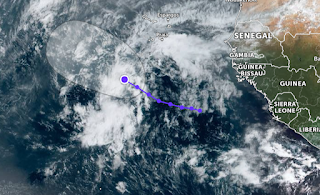
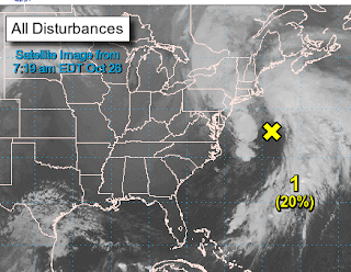
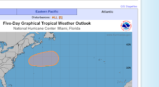
https://zoom.earth/ is an excellent site where you can zoom in anywhere in the Earth be it cold front or hurricane so make sure you use it often. Note Invest 95L near Africa still with low chances of developing.
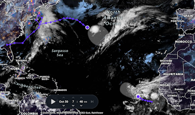
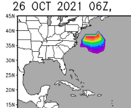
The always wonderful Zoom Earth shows us both Invest 94L (at 90% go for lift off) and our new Invest 95L down near Africa from one of the previously mentioned African waves that came off low and looking to tango. It's been an odd October and the NHC has been very quiet, yet now was we roll towards November they seem to be want to upgrade and use the name Wanda. The weather in most of Hurricane Country is cold, and even cool weather made it down to South Florida where a front will fade away or possible linger a bit so we can watch that. But the long term prognosis here is Winter is in view...way down the road on the horizon as temperatures in the 40s are already forecat for Central North Carolina. Winter is definitely winning but it's still Hurricane Season until November 30th so let's check out our tropical contestants!
As of 8 PM Saturday evening.
Invest 94L with a 90% Chance of Forming.
Little Yellow Groupie Invest 95L Watching...
94 looks small ....all in all.
95L larger, more diffuse, just off of Africa.
Rememember I mentioned the late African waves...
...this is one of them now an Invest.
Invest 94 tracks from Spaghetti Models.
Invest 95L below...
NHC has been so quiet all October...
Now we have 2 invests on the map.
As for me adding winter clothes to my wardrobe.
But ready to write about anything tropical.
That blue seeping down is cold air.
Cold air usually puts the lid on tropical threats...
...on the East Coast.
But the season ends on November 30th...for a reason.
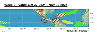
Will Something Form in the Coming Week? Wanda... Is She Out There? Models Sniffing Around.... Wild Weather in the South as a Cold Front Slices It's Way Through Parts of Florida & NC
Let's start with this graphic.
It's a very good place to begin.
It will be updated soon so we can compare and contrast.
Sure looks like the Atlantic wants to get a named storm.
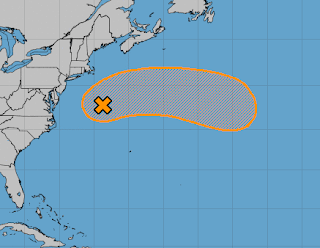
There's a wave off of Africa that actually shows up on some of the model runs, yet the NHC has not yet gotten their yellow crayons out and when they use it ...it's to highlight Invest 94L that's still parked over the Northern Atlantic. The clean up in the Mid Atlantic and New England is ongoing and some people are still without power. Normally that area gets slammed by some late October hurricane but even without a named hurricane (just a no name storm) they got slammed just the same.
So this is based on various models.
Amazingly one wants to play....
...with what should be Wanda.
But who knows who gets the Wanda name?
Yes the SW Caribbean is trying hard but still nothing.
If the NHC puts a yellow circle up in the MDR ...
...then we'd have what to talk about.
For now we have a solid purple blotch...
...low off of Africa.
These are the signs we watch that often foreshadow more discussion on models and NHC yellow circles. But it would be easy to say the hurricane season is so over this year, except for some subtropical wandering around the middle of the Atlantic getting energized perhaps from eels in the Sargasso Sea (should it really wander that far South) but I'm not going to say it's over til it's really over. So keep watching.
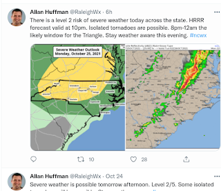
There is severe weather slicing through the Southeast today as a line from Florida to North Carolina is pushing through bringing with it strong storms and the possibilities of tornadoes. Here in Raleigh we are prone to nighttime tornadoes and the line in fact will be strongest in the middle of the night. So, hope everyone who reads this that is in this area in general keeps their weather alerts on their phones. Just in case...
In truth there are a lot of weather warnings outside of the Southeast, but a good percentage of my readers come from those parts so mentioning it.
Hey I can say that a few of the model esemble members show something and that would be true, but I can't say anything will develop just yet. But I can't say it won't.
Either way we have severe weather on the maps, a line producing tornado warnings slicing thru Florida and the ocean has an odd look. I personally think they should have upgraded Invest 94L to subtropical depression or something ... at least flown recon in as the winds were easily tropical storm force and it socked New England with yet another punch that came from something like a tropical/subtropical system. It's had a very hybrid look to it, often looking like a Superstorm but it was defintely one heck of a cyclonic bomb!
I'll update on Friday. Stay tuned. Stay safe! Enjoy the weather!
Besos BobbiStorm
@bobbistorm on Twitter and Instagram
Ps Took a nice road trip yesterday through the back roads of North Carolina, places you don't see on the Interstate! Small homes tucked into hillsides, trailers and huge homes in the middle of nowhere. High hills that look like small mountains and fields of cotton. Lots of autumn color mixed in, the maple trees were literally on fire especially at sunset. Listened to Willie Road House on the car radio as the miles passed by as we got closer to Ashboro, Siler City and it was simply wonderful especially for a Southern girl who loves back roads, horses running in the field and cotton growing in the fields and Willie and Waylon on the radio.
Whenever I pass the signs for Ablemare I smile, because my youngest brother had the biggest crush on Kellie Pickler and well driving the roads near where she lived, grew up and others live, every day lives, falling in love, out of love and back in love... watching the sunset and giving thanks for another day. And, smiling.......
Fall Colors, Invest in Atlantic Will Go Eastbound Eventually and Flooding, Windy Storm in the NE
Wound up beautifully there.
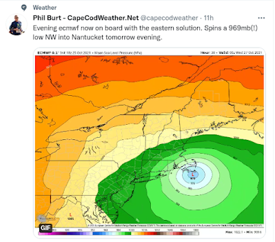
Storming, wild day on Cape Cod.
Yet... no name.
Yet, NHC running models....
...for the storm that hads to Portugal.
I have several friends who keep asking me "what's up with the NHC and Portugal?" and I just reply it's part of their coverage area, yet in the last few years they have become very protective of Portugal. Perhaps this next storm ?Wanda? could put out the fire in the belly of the Volcano? Just wondering what happens in such cases but Portugal is sadly not Las Palmas.
This is the change of the seasons as we move from tropical to more Northern Winter Storms that are coming in so early and strong that the 'Noreasters deliver cold, nasty squalls of rain not snow. But snow is coming eventually. And, eventually the NHC may get around to naming this whether it goes to see the Queen or Portugal.
I'm on the road today as my husband had a business trip and I had a "get out of Raleigh" day, shopping in a real Mall (Southpark, Charlotte) and a nice road trip through areas higher than Raleigh and closer to peak in terms of fall foliage and it was really beautiful, stunning and insert any adjective you prefer to describe Autumn. Yes, I'll hold the camera the way I need on any given day :) You can see color like that in Raleigh but not as easily .... especially with a bright sun vs heavy low clouds.
North Carolina has some of the nicest Rest Stops in the country, there's one near the Dismal Swamp that doesn't look so dismal and one built like an old tobacco barn, and the closer you get to Charlotte everything goes NASCAR... really. The one above has a babbling brook and a waterfall, nestled between Knock Out Roses still in bloom and a backdrop of Fall Colors.
The area near High Point and Winston Salem is truly special. You don't have to drive the length of the state (long) to see varieties of trees aglow. In the sun this almost hurt your eyes.
We do have color in Raleigh but the issue is that we have so many pine trees and mostly hardwood downtown vs out in the suburbs where I live. North Raleigh used to be farm land and hunting grounds, and when they stopped growing produce the land was left to it's own and that means Pine Trees filled in everywhere and everything, though differently from the Sandhills. The towns along the way on the way to Charlotte the way we went have a mixture of hardwoods and they all turn at a different time, so many lost leaves in the big storm the other day while others are just hitting their prime. It's a good time for a road trip if you are into such things.... usually I head East towards our beaches, but this is October and this is as good as it gets weather wise here if you like Fall Weather.
As for the tropics I'll update when back in Raleigh and today is a day to stay safe if you live in the Northeast as high winds and weather is still in play for the rest of the day.
Have a good day, enjoy the weather you got and if not ...find some weather you love!
Besos BobbiStorm
@bobbistorm on Twitter and Instagram.
Ps... here's some real Up North Fall Colors on a wet, nasty day when the river was approaching flood level and well you can see how woodsy it is up there. You also lose phone service, one by one all the phones in the car lose service and the trees close in and the roads get narrow and it's interesting; not my cup of tea but oddly I have a daughter who loves it and riding those roads is her happy place.
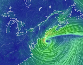
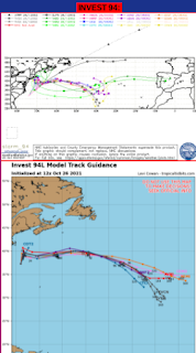
Invest 94L & Ida Remake.. Hopefully No River Flooding... But...Serious Wind, Rains and Wild Weather NJ to NE .. Circle Off the East Coast Stronger Chances for Wanda the Fish
Invest 94L Models.
Oh look...it appears on the 2 day!
Healthy looking on the 5 day.
A Fish Named Wanda? Maybe.
Another pretty graphic of the off shore storm.
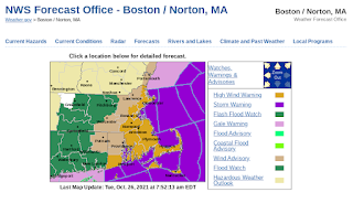
But check out these warnings...
Not good unless those are Halloween decorations!
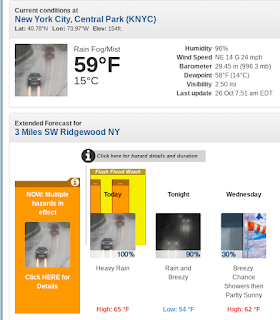
NYC area below........
Meanwhile, there are water rescues going on in New Jersey currently so I'm not too confident in those measures. This is not tropical, this is a wet Noreaster, forgive the Miami girl living in Raleigh for butchering the odd spelling of that Northern storm name!
A cyclone by any name does the same damage.
No name or a name.
Winter or Summer....
Fall Madness...
The barometric pressure is equivalent to a Tropical Storm.
Serious storm moving towards New England and New York, that formed off the Carolinas after pounding this area with rain yesterday. Fast moving storm that moves like a hurricane or a Perfect Storm remake but it's another in a pattern of looping lows off the East Coast that hook in before hooking out again. Like that stupid song "you put your right hand in you take your right hand out" (apologies if you like that song) stuck on a loop playing again as we end October, reminding everyone of Ida on September 1st storming her way through the NE before waving a final goodbye.
Remember the song "One way or another" ... because that is what happens with Mother Nature. She finds a way sometime around the Autumn Equinox or the first Full Moon to toss a tempest into the mix and try and push the seasons along. Indian Summer is moving into the rear view mirror and you better start thinking what you are going to make for Thanksgiving (Pumpkin Pie or Flan depending on where you live) because the times they be a changing.
The weather powers that be insist we will NOT have river flooding the way we did with Ida and they are putting "measures" into effect to minimize flooding and the problems we saw last month. Time will tell on that one.
Orange Circle 40% in Atlantic - Hurricane Rick Makes Landfall in Mexico. Cold Fronts. Lows. Storminess.... Gonna Be a Spooky Halloween? As Long as it's Cold I'll be Happy!
Words matter.
Discussion here can make you dizzy...
I watn you.
It is what it is, let's just say that for now. It may be subtropical at some point, it may at some time become tropical. Mike calls it officially "A Fish Named Wanda" and can't believe I didn't think on that to be honest! So we may have a Fish called Wanda... that goes wandering around the Atlantic. And there's Hurricane Rick down in Mexico. https://zoom.earth/
Let's look at another view.
Closer in there's a huge batch of rain about to cross over Florida and a nice coastal low off of the Carolinas. And, check out that dark, dry air in the SW Caribbean. Getting harder and harder to see how something really could develop there, climatologically favored or not.
Yes models spit out possibilities like water melon seeds on a sunny day. But it's not summer and we are way deep into Fall so they'd be pumpkin seeds. Maybe we could get a 40% orange circle down there and then just call it a day? Yet, we can't and the 2021 beat of the hurricane season goes on with high latitude trouble of the tropical and wintry kind. But as you can see below the models keep churning out long range, possibile storms that never may form.
And we have a Land Cane!
No, it just looks like one.
And I have a chance at possibly severe weather later today.
Earlier today we had a severe storm out of nowhere.
All red on the rada and the Apps had to play catch up.
As did the NWS... words matter.
Red words here mean "changed" discussion....
I took video.
Weather Nation, TWC asked to use it.
Ended up being a good day.
Not a tropical one but a weather day.
And, I love to play in the weather.
So by any name, we have storminess.... no named storms in the Atlantic Basin and yet we have storminess, and coastal lows and lows over land, and dangling cold fronts that are reinforced by the next front.
There is a lot of storminess going on currently. Multiple storms along the West Coast, as Rick approaches from the South and the unnamed NW Storm pounds the coastline, fronts are parading South and East and something seems to be forming from it all off the Carolina Coast and slingshots, careening around towards Cape Cod but will it get a name? Mucho storminess; I know you're wondering is that a word?
Still Watching the Caribbean - Models Get Interesting For November. Enjoy Your Weekend!
Still watching the SW Caribbean.
Quick note before going into the weekend. Any other year we'd be watching carefully something in the Caribbean, but we are mostly watching models that are hinting at something forming. We are talking very long range models for early in November and they flip flop around on track and intensity. And, until there's some consistency on evolution of any named system I'm not saying more.
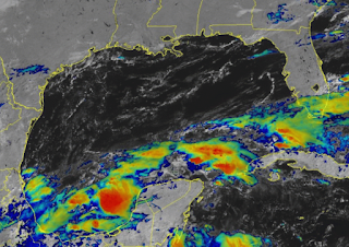
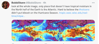
Any other year I'd see this and think "oh wow" but not this year. And, why? La Nina is here and other factors are positive and personally I do think this has to do with the Volcano. Why? Note the Mimic image below, all the other tropical regions are orange red and juicy but not the Atlantic.
From the coast of Africa to South America it's dry....
... so thank the volcano for that one.
Needs more studying but everyone is asking the same thing...
Now Days Do We Say .. November Remember? As the Hurricane Season Often Goes Late These Days? Strong Cold Fronts, Possibilities in the Tropics in a Week or So... So Keep Watching!
You don't need to know a lot about meteorology and all the charts and maps I use to know that there's not much going on in the Atlantic in the tropics. A few bumps of yellow like yellow leaves that dropped into the backyard pool. All the orange and yellows are up in the high latitudes where Winter is creeping slowly in. Check out that swirl up in the North Atlantic! Winter is in the wings.
And, another issues here is the Eastern Pacific has been healthy this year, whereas for no apparent reason the Atlantic over the last 6 weeks has not lived up to it's expectations. So take a look at this map below and you can see what I mean in that what forms in the deep SW Caribbean keeps crossing over into the Eastern Pacific moving Westbound.
While it is possible and happens that things forming in the SW Caribbean move North and catch a cold front, this year they have been slipping West. Sometimes a piece of that remining moisture makes moves North away from the part moving West and sneaks North looking for a free frontal ride out of the Caribbean. One or two models hint that could happen, but as the majority of models do not show it ... I'm just saying it's possible but not currently probable. And, yet some models show indications we may have something to track so we keep watching but nothing to worry on.
Years ago before we had the great models we have now, we used to live and die by this graphic. Candy Cane red always looks good on this graphic if you want something to track in the way that Candy Cane dresses look cute for Halloween or candy canes for Christmas! But will something form and grab that diving wild cold front that's coming down the road or muddle it's way into the Eastern Pacific.
Now keep in mind this is one of those strange anomalies of this year in that this time of year it's usually dead quiet in the East Pac and still bubbly in the Atlantic, yet not this year. But maybe...
I said I wouldn't show those models for early November, but since Mike is showing it I'll use his graphic! I just don't feel confidant enough to wax poetic on it but love to listen to Mike who claims he has memorized my mind in a tropical way (of course) so yes I am watching it. We all are watching it, but we watch lots of things that never form.
This is the long range, really long range image that people watch that puts together all the models people watch long term to see if there is a chance. You know as in "Is there a chance Bobbi? Tell me there's a chance" and hey I'm not going to argue with November weirdness in the tropics ... Fronts dive down vs dipping down and then they snag whatever is down there, sometimes they pull it wide right aiming for PR to get out of the tropics going NE and then suddenly the front goes stationary and it wanders about and said system weaves around and moves back towards Florida and well if you remember Gordon you see what sort of system this time of year can bring when fronts are active yet it's not quite Winter.
Yes, this track actually happened in 1994, forming on November 8th and ending on November 24th. It should have had it's own book titled "3 Weeks in November" or as I have it bookmarked as "Hurricane Gordon Wild Track" but tracks such as this one do not happen often. But they happwn when a front dives down, grabs it and then loses it's grip and the storm swirls around in odd ways waiting for a really strong front to KICK IT OUT!
1. Westbound, really low wave moving towards South America.
2. Tail ends of fronts.
3. Whatever moisture you see from the Yucatan down into the SW Caribbean.
But even storm chasers are beginning to drool over the next big cold front! Not the next cold front, but the one after that...
November Remember these days is the saying but what will really happen? There's a chance but until I see something coming together and jelling I'm just watching curiously. Check out that crazy, strong system coming into the NW and you know what enters stage left does not stay there but moves center stage down the road... keep watching.
Besos BobbiStorm
@bobbistorm on Twitter and Instagram
Instagram whatever, Twitter mostly weather!
Ps Had this song stuck in my head all day yesterday so sharing it with y'all ...enjoy. It's perfect for November Hurricanes and ghosts of Gordon!
Quiet Tropics Today. Tampa Bay Hurricane 100 Year Anniversary Coming Up Soon. It Formed in an Area Where We're Currently Watching as It's Where October Storms Form...
Short blog today with nothing much to say on the current quiet state of the tropics, but a lot to say on a historic anniversary coming up this week. A hundred years ago, a Category 4 Hurricane slammed into Tarpon Springs and the Tampa Bay area. Tampa can get hit but rarely does and usually does get slammed in late October. There's a mystique that they somehow avoid hurricanes making a direct landfall, Jacksonsville feels that way also, and yes while they both get side swiped sometimes, suffer some flooding they usually are lucky and get to watch them sail away to some other destination. In 1921 Tampa's luck ran out and they had quite the mess to clean up and a short term set back to the Florida Land Boom, but they did snap back. Their short term monetary loss was Miami's gain as the money went there and Miami boomed while Tampa tried to get back into the game as fast as they could.
Fast forward today and Tampa is a world class city with universities, tourist attractions and two sports teams that recently snagged the Super Bowl and the last World Series. Miami has to be a bit envious there and to be honest Tampa has hanging moss and more of a taste of the seasons than Miami does so if you wanna move down South .... remember Tampa is thriving! And, yet until the hurricane season is over they will every October look down to the South and make sure there is nothing forming down there.
The NWS out of Tampa is tweeting on this historical hurricane anniversary this week, so check them out and while at it you may want to do some research on Tampa Bay Hurricane History.
And, yes we are all watching the Caribbean to see if something, somehow can try and form or perhaps close in near Cuba or the Florida Straits, but if it does it will most likely be snagged by the next cold front as cold fronts are all the rage these days!
Location: Miami, Raleigh, Crown Heights, Florida, United States
Weather Historian. Studied meteorology and geography at FIU. Been quoted in Wall Street Journal, Washington Post & everywhere else... Lecturer, stormchaser, writer, dancer. If it's tropical it's topical ... covering the weather & musing on life. Follow me on Twitter @ https://twitter.com/#!/BobbiStorm