A writer and a tropical muse. A funky Lubavitcher who enjoys watching the weather, hurricanes, listening to music while enjoying life with a sense of humor and trying to make sense of it all!
Thursday, June 30, 2022
NHC Says Probably Tropical Storm Bonnie Later Today. A Look Back at a Similar June in the 2018... Kind of a Typical Late June in the Tropics. Tomorrow July. TEXAS RAIN... (could be problematic further inland)
Colored Fruit Loops on the menu for Breakfast today.
Fruit Cakes on the map.
Fruitty Pebbles if you prefer.
Two is Westbound with a name or not, going West.
Yellow X is meh but a wild card down the road.
Orange X is RAIN a lot of rain for Texas and beyond.
Note rain could hang a right....
Headed for Virginia. Maybe.
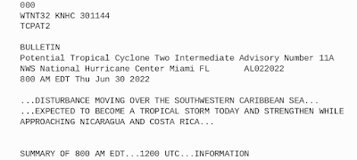
8 AM from NHC on PTC Two below!
* * * * * *
Take that to the bank, probably gets a name today.
NHC seems pretty sure.
So Bonnie could form on June 30th!
* * * * * *
In the long term there are always possibilities and then as they move into the short term they begin to fade away one by one. That's why we say "June Too Soon" though there are exceptions to the rule. The job of a model is to find a chance for possible development and they are upgraded and the models run again in several house, they are as Jim always says "guidance not gospel" so take the image below for WAY OUT in July as merely possibilities.
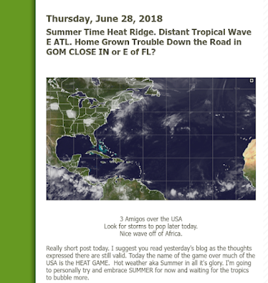
A look back in time to 2018.
Summertime and the living was hot and heavy.
Tropics came to life eventually in big ways.
A blog is a wonderful thing. My blog is a diary of sorts of tropical action and some personal discussion over time and when you look back you can almost always see the correlation to the current state of the tropics. June had been a beastly hot summer in Raleigh and the tropics were still flirting with activity. A very early GOM system developed, June was rather quiet and then close in action developed in July, as the year progressed we had Florence. Michael traced the earlier GOM system that began down by the Yucatan. "Waiting for the tropics to bubble more" is the phrase I used in 2018 and can use it again in 2022 on June 30th, 2022!
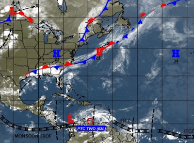
Lots of possibilities, but we aren't there yet. As seen below there's a front stuck across the SE, an active ITCZ but weak as it is in late June. Lows are marked but do not denote an official name, just the way of the world in the atmopshere. Gulf of Mexico action threatening. PTC Two more over land than not (which you see if you click on the image or enlarge it) and yet another Westbound Tropical Wave.
Will PTC Two becomes Bonnie today? Maybe.
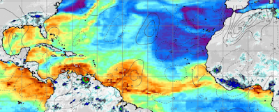
This is through July 5th...
This coming week shows possible development.
Red in Carib and candy stripe in GOM
(candy stripe mostly RAIN)
A wave off of South America periously close to crashing into it unless it lifts but the jury on that doesn't look good. If you use a magnifying glass you can see "something" of Bonnie on the coast of South America. That "something" will emerge over hot water close in and take aim at Central America.
Tropical Possibilities! GOM Close IN Relevant Weather Maker for July 4th Weekend - PTC Two Close To Being Upgraded But Has Problems. May Go the Distance to the Pacific! And, Where Was BobbiStorm This Weekend
A bit impressed with Potential Tropical Cyclone Two in that it's managed to maintain a large shield of convection with a rudimentary look of a poorly defined tropical depression or named storm! It takes more than good satellite presentation and consistency to get a name, and between Recon and Ground Observations we should know soon enough if it gets one today or not. My money is on an upgrade, but I'm not putting much money on it mind you!
There is what appears to me a very small closed circulation hiding along the coastline and it has more land to cross before it gets into the sweet spot of the SW Carib where it could intensify into a formidable little storm. The NHC has it at 70 MPH way down the line. Forecaster Blake wrote a good, honest description and I suggest you read the discussion yourself as words matter more than pictures. In this case, despite a picture making it look like a very small cyclone the observations do not show that is true and it's moving fast on it's way towards the Eastern Pacific where it may shine as named storm there. Good discussion, link below.
Louisiana also needs to watch this because of shear.
So weather becomes displaced ....
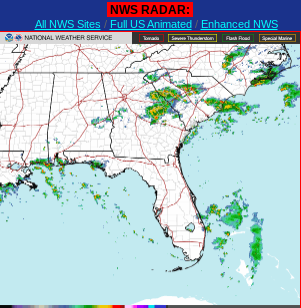
Lastly there is a Mid Level Low off the coast of FL.
It already worked it's way down from Upper Level Low.
So... watch it.
It's going to amp up the weather in S FLA today.
Could it do more?
You never know, homegrown storms in June are a thing!
And again we are moving towards July 4th Weekend.
So ANY heavy weather along the GOM is a problem.
A problem for the tourists and for the beach economy.
A bad July 4th is hard to recoup losses from...
And, RAIN is in the forecast for the next 5 days!
Across a good part of the South's beaches...
Not Chamber of Commerce Weather!
Really lastly there are always waves out there.
Some models develop them....
...track them more WNW!
Others do not.
Never stop watching tropical waves!
And know Homegrown happens!
I'll update later today if and when the NHC does.
Also a bit of my personal story as I've been away.
Many of you have been patient.
And I appreciate it!
Wedding picture booth fun!
That's me on the left.
Blonde for the summer ;)
On the far right is my friend Leah.
I've known her since we were 18!!
Close friends in LA in the 80s...
Our kids got married this Sunday!
Beautiful bride who lived in Raleigh also!
High heels ... low heels.
Two set of heels wedding.
I wore a kind of Southern Flapper Dress.
Everyone said it was very flapper like...
...that was the idea.
Fun to dance in...
...no ...no videos here ;)
Lots of great memories.......
Wednesday morning here in Raleigh. I have to type that to remind myself that it is Wednesday as for the last week I've been praying everyone's flights are on time to my son's wedding as the week or two before has been nothing but cancellations and serious delays in air travel. My brother went to Seattle for a cruise to Alaska (he loves Alaska) and their 10 AM flight out of FLL was delayed 4 times and didn't take off until 10 PM so you can imagine how I felt about the groom and his 3 children flying in the morning of the wedding. Then there's the constant threat of Covid sidelining a member of the wedding party at any moment, along with the awareness that if you travel to such events or anywhere you take the risk of getting Covid or the common cold or possibly a nervous breakdown waiting for your flight to finally take off. We drove down to Atlanta from Raleigh, but many flew in from Miami and Los Angeles.
So that happened and yes it happened. The jury is out on who is sick or not but so far everyone is hanging in there and managed their trips back home. We hit a total standstill on the highway out of Atlanta about a quarter of the way to Charlotte and rather than sit on the highway an estimated hour we got off and drove the back roads. I love back roads, especially in the South, they never really disappoint and are never boring. Okay, we got in way later than we might have had the boring highway route cooperated. And, as we drove through very rural farm country, very small towns and along side a few National Forests (Sumter, Uwharrie to name just two) we usually only had one bar on our different T-Mobile phones and sometimes barely a bar so I was totally out of it Internet wise and yet I enjoyed the ride as we listed to the Margaritaville channel on the car radio. Okay every time I got two bars I went to Twitter fast.
We stayed in Atlanta by an amazing couple in a beautiful home with incredible accomodations that allowed my husband and I to have one guest suite and my grandchildren were able to stay in another suite next door; a teenage granddaughter happily got the 3rd floor attic room to herself! But, they had no WiFi on purpose and for some reason that part of Sandy Springs has crappy service on T-Mobile on every phone with that carrier. Most of the people there do not use that carrier. Oh, well... the phone worked, we texted, Whatsapped and occasionally a photo was able to be shared. Slow phone service is better than nothing. Why do they not have WiFi is a good question. It's by choice as they both work for an organization that they are extremely dedicated to and they are young and they decided they can do everything on their phones, but if they had WiFi they'd barely talk to eachother or do anything but work. So they work at their office around the corner during the day and at home they share their lives together talking, planning and using their phones with the better carrier to do anything they might do on WiFi other than get lost on their computers. Different strokes for different folks and they are good folks and Millenials are different from Baby Boomers who seem to have to have access to everything out there available immediately. In truth, if you have a cellphone and are on a trip for a family wedding/reunion with people you haven't seen in a long while, events running nonstop to go to and preparations for a wedding why do you really need to be online nonstop 24/7 ...especially when there is nothing really happening in the tropics but conjecture and curiosity?
Would you beleive that during the actual wedding ceremony I put my phone away and let all the other people there take pictures!! And, they did, now my phone is filled with pics from WhatsApp and Messenger and well why can't we go back to AOL where everyone communicated on ONE PLATFORM? Oh well. You can't go back can you??
I had a lot of quality time with my grandchildren and with old friends from both Raleigh (who moved away) and LA where many of us lived in the 1980s. I lived in the minute for a few days of my life for a change and it was fine and dandy. There also wasn't a Major Hurricane barreling towards a date with some coastal city going on... just some yellow, orange and red circles and a potential tropical cyclone. This is why many of my friends at the NHC over time take their vacations in June, because June is usually too soon. July, get ready and August you must as the old rhyme goes.
I'm back, I'm here and I'll be laying low today and not doing much but tracking the tropics.
Two things if you are still here.
1... My daughter-in-law's nephew is about to be 10 years old and he is the most amazing amateur meteorologist who lives on Discovery Channel and loves his Pro Radar etc and devours Zoom Earth! You can learn a lot about meteorology online as a child even without being online in groups or with total access to the Internet. His father, who taught science years back, seeds this child's love for Earth Science with carefully approved sites and Apps and the kid knows every detail of every hurricane over the past two years, though admitted sometimes he gets 2020 confused for "a minute" with 2021 storms. He lives in California and he first became interested in cyclones because of Hurricane Laura. He wants to call me his "step-grandmother" he told his mother but that's not really the right word but he is friends with BobbiStorm ;) his Aunt's mother-in-law LOL. Unreal!
The little kid on the right in the NASA tee shirt!
Dressed for the holiday of Purim.
Science lover that he is...
...I'm not making this up.
My son said "you met your match"
Nothing like youthful passion!
Hurricane/Weather Tracker.
2... I have a friend who I was in varous writing groups with when I first moved to Raleigh who recently posted her thoughts on a recent trip that she and her husband took and how difficult it is for people with disabilities and note they both have strong disabilities; he more so than her but they both manage marvelously usually. Best advice being "drive if you can" and if you cannot know it's not so easy. So going to post her thoughts her as we go into Summer Travel and possibly evacuations for hurricanes coming to visit!
You can read her article there as well as her recent thoughts on their trip and other things that may interest you.
Note I have a son who had a trip to JFK from MIA a few weeks back in the late evening, after many delays they rescheduled him on a flight the next day. My brother spent over 10 hours at MIA waiting in a very crowded, fairly dirty terminal to go to Seattle for a cruise that luckily wasn't for a few days as he is visiting family there as well. Traveler beware I suppose is the point here.
AND AS IT RELATES TO HURRICANES......... PLAN AHEAD and have a Plan A and a Plan B because you may seriously need Plan B and Plan C is going to probably be hunker down anywhere you can!
Thanks for reading... I'll update the blog when the NHC updates either TWO or there is more information on the other areas I spoke about at the top.
Sweet Tropical Dreams and Happy Travels ...
Besos BobbiStorm
@bobbistorm on Twitter and Instagram
Twitter mostly weather and Instagram, Lord only knows... weather and whatever!
Ps excuse any typos I'm exhausted. Going to watch Mike do is Facebook Live and go back to bed to rest a bit!
Trio of Possibilities. But Which One Gets a Name? Name of the Game is Still HURRICANE PREP. Better to be Prepared Than Panicked with a Hurricane Warning!
Short, sweet and honest.
Lots of things to look at for possible development, but which one gets the name. And, which one is currently most important! Most relevant? Yes, Potential Tropical Cyclone Two has weather and strong winds, but it's also periously close to land and that inhibits tropical development. Surface observations in Trinidad and adjacent islands so far have not shown a closed center of circulation.
Eartnull shows a maybe but still not obvious at the surface.
It's trying... shear, land don't help!
Later over water again it has a chance!
Track is still very, very low!
Weather in Trinidad currently.
Rainy with some wind.
But the GOM... Earthnull a real wow!
More so the models show problems.
Problems far inland possibly.
Look at those models!
Some show Oklahoma gets rain ....
Other show the rain gets caught and pulled NE...
As for the beautiful tropical wave behind it, it's got the same difficult path as TWO yet models pull it higher, yet it's not looking as good as it did when it came off of Africa. And, that is the song of June, they pop off Africa looking exciting, they hold their breath for a selfie and then they begin to fizzle.
CLIMO wins. The wind pattern isn't supportive, the water temperatures not supportive enough and Saharan Dust is still there doing it's June and July thing. And, THAT......is why the tropics come alive in late July going into August and September is a time to remember.
So always look close in at the Gulf of Mexico and at any remnant of a cold front dangling near South Florida or the Carolinas for possible fast spin up, close in action. And we still have fronts dangling....
Two putting on quite the show.
Trying to get a name.
Front 1 is 95L connected.
Front 2 out in the Atlantic... watch it.
But prepare your hurricane plans.
Better to be prepared than to panic!
On a personal level...
In the 1980s I lived in California. One of the nicest couples I knew were part of a group of 5 or 6 couples who would get a babysitter and go out for the evening to play PACMAN or PINBALL or take walks at Ports of Call or have drinks at the Queen Mary. Our kids played with eachother as if we were one big family and we worked hard at our jobs with love, passion and dedication. Long Beach, then LA and I did LOVE LA! Late nights at Disney together walking around talking as we had Summer Passes to get in at night. Quiet times on the Jewish Sabbath or other holidays when we hung out as a group of close friends. Long Beach was my happy place for years and then we left and moved back to Miami. This past week while I was missing in action from tropical discussion on the blog and online I was marrying off one of my sons to the daughter of one of my close friends who live in LA. The wedding was in Atlanta where the bride has been living. Amazing how life works out. I have another daughter-in-law who lived in Long Beach and LA and she also was close with this family who married their daughter to my son! (if you could follow that...) The mother of the bride watched my son (the groom) when I went to the hospital to have my 2nd daughter. I mean how connected can you be? Amazingly the couple met through a friend and were married this week.
In Chabad the Sabbath before the wedding is special filled with party like get togethers and the wedding is huge and intense and the days after have after wedding celebrations. It's been a whirl, a real storm of gratefulness, love and awe that this happened as trying to get anything pulled off in 2022 between Covid and travel problems at the airports with flight arrangements....NO ONE HAD A PROBLEM... OMG that in itself is a mini miracle.
Oh I also did the Atlanta Aquarium, because young grandchildren really love it.
Home, back at work and the tropics may heat up soon so Bonnie and Colin may form soon! And, if not sooner rather than later.
Thanks for your patience. I had a great time and am still in awe spending time with friends from California, Raleigh (oh I forgot to mention the bride worked here for several years and I was close with her here) and Florida! Kind of like a family/friend reunion and life goes on.....
Invest 94L at 60% Orange Now, Tracking Low into the Caribbean. Is Invest 95L Soon to Form Behind It? Wave Train Rolling....
60% for 94L at 8 AM
Models in unison on early track being Low.
Stays South.
I'm going to add that this track follows the track of the last few waves that I have pointed out here and on Twitter have made it to Trinidad vs the coast of South America. I also said on Twitter the next two could get further North near Barbados. The models are showing that. I don't think this wave is an anomaly as much as a pattern and the start of a very early Cape Verde season. You have spurts of energy there early and then it slows down and then the real problem waves come along but we are definitely way ahead of schedule CLIMO wise and otherwise. Regarding tracks shown above please remember they can extrapolate further West or pull North in future model runs. Depending on where 94L develops and how fast it develops will set it's course; keep in mind how well organized it is will be the key to how strong and threatening it could be.
Remember on Twitter there are some excellent tweets in Spanish and other languages that you can translate if you can't understand the language. The one above is a case in point. There are not one waves now but two healthy waves and another further in off of Africa. So the possibility of Invest 95L showing up soon enough is there! Remember when a lead wave goes low, often the wave developing behind it goes further to the North at some point. The image below shows Africa and the actual wave train is extemely well developed for June 24th. They are nicely spaced out as waves go and that gives each wave a bit more breathing room then when they race fast over taking eachother which inhibits development. Could happen down the road, but currently just pointing out this is not a one and done situation as we have to face the harsh reality that we have be crusing into Hurricane Season faster than expected further East than expected. It's worth noting that the forecasts for this season did show a fierce season and a busy one!
I'll update later when I get to where I'm going and we can see the afternoon models come in a bit. Take this to the bank and build up a supply now of hurricane supplies for riding out a hurricane and/or a plan for where you would go if you need to evacuate. Don't expect you can fly to Aunt Martha in Omaha without checking with her first as she may have booked a cruise or met a cute guy at BINGO and moved to Vegas to an adult living facility and rented her little home in Omaha out to someone else. Just saying... plan in advance not while on the road stuck in traffic inland trying to get a hotel room or figuring out which relative to drop in on.
Ready or not, the wave train has started and add in the "home grown" component and we have only just begun!
Besos BobbiStorm
Follow @bobbistorm on Twitter and Instagram for real time discussion.
Twitter mostly weather and Instagram whatever.
Ps Remember ...depending on how far West it gets it can crash into Central America or lift up into the Gulf of Mexico so know where it goes down the road is the issue, but for now it's Westbound!
UPDATED 10 PM INVEST 94L -ORANGE 40% NOWon Thursday Night - African Wave. Close In Something Possibilities. Watching the Long Tracking Wave is the Tropical Game of the Day. Traveling to Family Wedding BUT Updating Always!!
Invest 94L
Models bullish on Invest 94L..they see a Hurricane!
In Charlotte for the night, catching up with the models and discussion from the NHC.
Some pictures below with discussion beyon that.
Orange 40% chances for development!
Getting more serious here.
Earthnull shows it's trying...
...not a flat tropical wave.
All the way to the right.
Enter stage right...
..contender for the name Bonnie.
Some discussion on models that I hate to post for more than a week away as they are a stab in the dark with the information they have currently. No closed center yet and therefore the model data to start with is corrupted as it's taken from an estimated starting point. But they give us an early indication of which part of the world most needs to monitor this system. The EURO takes it through the islands, keeps it low and into the Caribbean near the Yucatan or Central America. The GFS keeps it more to the right (North and East) and the Canadian that has had some success this year gets it to the Islands and stair steps the storm far to the NE of the other two putting the Bahamas on notice to pay attention. If you believe the EURO this could be a Mexican adventure. If you believe other models or ensembles it could pose a risk to the July 4th Weekend along some beach, somewhere in it's path beyond the Bahamas if you get my drift. Just really too soon to tell.
Also it's worth mentioning size matters and this is a large system and they take longer to develop and can have problems aligning vertically in the atmosphere. For a tropical wave to become a tropical depression and develop into an Hurricane they have to allign perfectly veritically or they run the risk of tipping over or losing their mojo if you know what I mean.
That's the EURO currently.
Gee right back to 93L territory.
The GFS below is to the right.
Won't even show you the Canadian...
...you'd need Xanax.
Listen, these models ARE NOT RELIABLE, they are an attempt at showing us where it might be down the road, but it's too soon to tell. What I can tell you is it is forecast by the models, many models, to develop and possibly develop into an early July hurricane looking for a landfall. Rare for late June and early July, but can happen. Everyone is posting pictures of crazy models with projections of landfall on Twitter, Instagram and Reddit and yet it's just a snapshot of what the models think on Thursday Night June 23rd! And, much will change from what it is now tonight and what it will be on July 4th, remember that!
Night, long day and tomorrow is a long day. I'll update Friday morning
Sweet Tropical Dreams,
BobbiStorm
Please keep reading if you did not as everything I said below is still valid except we are at level Orange tonight not yellow as we were this morning!
* * *
20% yellow circle in 5 days (actually in 2 days also)
That's the wave's "baby picture" when it rolled off.
Look at the curved band like features.
Structure. Was a WOW from day 1!
This morning's visible imagery.
Shows a consolidated area of convection.
It has model support.
Models have been loving it for days.
Before it rolled off of Africa.
Also note the large area of spin off the East Coast.
No yellow circle but a weather maker.
Kind of the opposite of a tropical system.
But it's being watched by many.
Impacts the area but also possibly the environment.
The graphic below is very unreliable in details, but shows general possibilities should this wave or something else develop. It's kind of like the ultimate fantasy game dreamer for people who love to track, study or chase hurricanes. There is strong model support for the African Wave, yet if you notice there are mutliple paths for this system as it's an ensemble not a solor player in the band. Caribbean, East Coast or does it just recurve up into the Atlantic? Time will tell. But, it's interesting to look at, while remembering never to buy into such a long range model that is basically "anything that could happen in the next 120 hours" and if you do the math that's far down the road. Anyone taking a road trip knows things pop up and detours happen or sometimes you drive along as if you are the only one on the road and you wonder where at the cars went.
So..... tropical hard truth and personal discussion today.. It IS possible that "the wave" could make it across the Atlantic, get a name and if it does the name will be Bonnie. Well, unless something homegrown does not steal the Bonnie honors!! Think of it as gentle reminder by Mother Nature to listen to the NHC and do HURRICANE PREPARATION NOW so you can be as they say "Hurricane Strong" if and when your town comes under a Hurricane Watch or a Hurricane Warning. July is next week if you haven't been paying attention to the calendar!
As for me... I'll be on the road and at a large, family wedding weekend filled with events and a joining together of old friends from differnet places in my life. I lived in California, as long time readers know, back in the 80s and I loved Long Beach, LA, West Hollywood and all my favorite ports of call to be with friends, party and as I was far away from hurricanes I studied a lot of geology ;) Seriously, my son is marrying the daughter of one of my closest friends who lived in Long Beach and I'm glad they found eachother after all this time, grown up on the East Coast. They both went through the difficult decision of divorce and wanting to start over they are charting a course together to start over and begin again and that's beautiful. I love happy endings and sometimes happy endings evolve as life evolves. When I moved to Raleigh with my second husband I was kind of in shock my friend's daughter was working here in Raleigh in our community and I watched her have babies and do her incredible work and it would amaze me we were in Raleigh not California, and somehow now I'll be in Atlanta where my parents lived before I was born (they moved back to Miami pregnant with me) and I have friends from Long Beach, LA, Raleigh and my Miami who will be all in one place! Kind of mind boggling how things work out sometimes. Several events with multiple so I'll be busy but you know me I'll be watching that African wave and the weather and temperatures while celebrating family events as well. I got the dress that has the name of "the ooh la la dress" because that's what my granddaughter calls it and various heels, a ton of make up and it's always good to pack a smile!
I'll update if the NHC updates anything on any area, but just remember this is a long tracker and the longer it takes to develop the further West it gets. A large wave such as this takes longer to pull together sometimes and it's late June and the water is not optimal that far out yet. But this could be a July Hurricane IF the things the models see currently continue to show up down the tropical road. A big IF but Bertha was a big iffy system far out in the MDR and it did make it all the way to North Carolina! More often storms like this crash into the Caribbean or Central America if they can fight off shear ... you just never know.
Not a lot of analog storms in recorded history. If only we could go back with a time machine and see what those wild "storms" ship captins wrote about in their ship logs were really like in detail. And, if only we could see ship logs that are at the bottom of the sea because the ship went down in the storm so we will never know how strong that July Hurricane might have been that took down some old beautiful ship that was bound for the New World but never made it! Or... pirates captured the ship, burned it and the Captain's Log went up in flames.
For now, it's hard to forget Bertha especially as I watched it longingly from Miami and then watched it slide by on it's way to the Wilmington area of NC where later in that year two other hurricanes made landfall as well. Oh what a year 1996 was in hurricane history, especially for North Carolina.
Summer Solstice. Sneaky Tropical Waves. Possible Home Grown Action? Long Range Models Strengthen Waves Day By Day. Longest Day and The Great Gatsby... Do You Wait for it or Hate it?
Watched Mike this morning on YouTube.
My preferred way of watching...
....listening.
Old habit, Mike in the Morning...
People either love or hate the Summer Solstice. It's the longest, hottest day of the year to many and those who love winter or cool fair weather absolutely hate this day. Others who love summer go hog wild crazy and celebrate by going to the beach or decking themselves out in their most summery clothes and best matching flip flops! To some they see it as that point when the days get shorter and rather than love the longest day they look ahead to days that are short on sunshine and long on dark nights. As I told a friend earlier this morning ... Miami kids kind of love the night, it cools off, the neon lights turn on and the party begins. In Miami the only time to play is really at night in the summertime when many skip town for anywhere cooler such as up in the mountains and "the mountains" to Miami kids are in North Carolina. Love it or hate it, it's here and summer is everywhere so celebrate in whatever way you can be it an ice cream cone or some cold watermelon with salt sprinkled on it ... it's a Southern Thing!
“Do you ever wait for the longest day of the year and then miss it? I always wait for the longest day of the year and then miss it!” Famous quote from Daisy in the Great Gatsby...
If you read "The Great Gatsby" in High School and you should have as it's required reading in most places as an infamous novel on the loss of the Great American Dream even though it glorifies that dream, but for many it doesn't end well or slowly slips away. Daisy waited every year for the longest day of the year she said and sadly said she often missed it. It probably would have been better had she missed it that year and then Gatsby would have been alive. Hope I didn't give too much away. One of my degrees is in English with an emphasis in F. Scott Fitzgerald, when I hear "Summer Solstice" or I think of those scenes in Gatsby that play out on the "longest day of the year"
Back to the tropics....
..nothing is officially happening.
BUT.....it's the beginning of a start to things to come.
Models show more than development.
They show the environment.
This image above says a lot!
1. Look at that huge High! Bright orange, red, hot huge High!
2. Note the small green circle with a closed circle around it entering the Carib.
3. EPAC took it's vitamins this year, it's busy when it's supposed to be busy!
4. More waves coming off of Africa, one by one or two by two it's a Wave Train!
The image above shows us the points I mentioned. Multiple tropical waves are crossing the Atlantic juicing up the atmosphere, eating away day by day at the Saharan Dust and now currently they are actually sailing into the Caribbean North of Trinidad, soon they will be cruising over Barbados. Those waves are sneaky, silent runners, running under the radar. They don't yet have circulation, and they dare to swim in the waters of the Caribbean Graveyard known by that name as shear is there this time of year and it will blow apart any barely there Tropical Storm. BUT.......the waves sneak in as waves and then end up in the Caribbean either crashing into Central America or finding a path North up into the Gulf of Mexico. This is how they have a chance for development later on, too soon and they are blown apart by shear or sucked dry by dust. Kind of like that book "The Tortoise and the Hare" story you that was required reading in PreSchool!
A wild card is the area off the Carolinas. Some models show something tries to form there. We can talk more on it tomorrow, if it continues to look as if it will happen. The water is unseasonably on the warm side (way too cold for me to go in beyond my ankles) but warm enough to support "something" and that's a favored area of development for late June so stay tuned.
Short blog today compared to yesterday. So please read yesterday's blog post as I was in a chatty, fun mood. Still in a good mood, just kind of short on time today.
Much love,
Besos BobbiStorm
Follow me on BobbiStorm on Twitter or Instagram.
Twiter mostly weather and Instagram ..whatever.
Ps.. I listened to "Summer Music from the 80s" on YouTube earlier and it played this song that was perfect as the eyes in "The Great Gatsy" are always watching.... always.
Location: Miami, Raleigh, Crown Heights, Florida, United States
Weather Historian. Studied meteorology and geography at FIU. Been quoted in Wall Street Journal, Washington Post & everywhere else... Lecturer, stormchaser, writer, dancer. If it's tropical it's topical ... covering the weather & musing on life. Follow me on Twitter @ https://twitter.com/#!/BobbiStorm