A writer and a tropical muse. A funky Lubavitcher who enjoys watching the weather, hurricanes, listening to music while enjoying life with a sense of humor and trying to make sense of it all!
Thursday, August 31, 2017
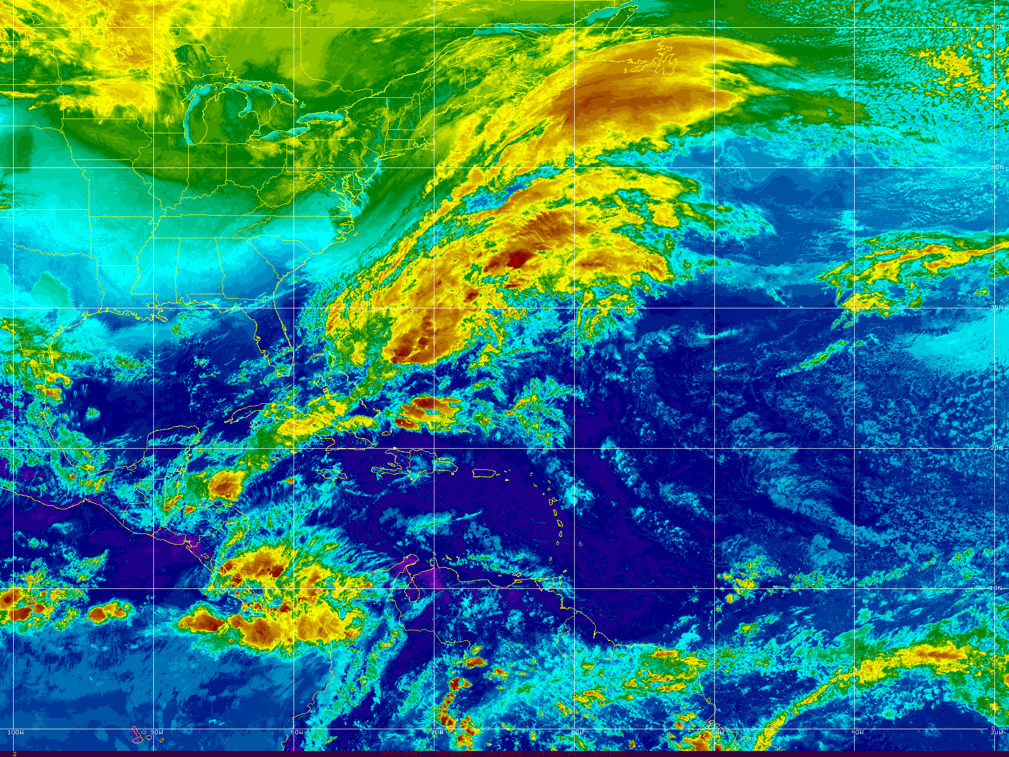
Hurricane Irma Forecast to Approach Islands as a Cat 4.
Very short post. I'm in Brooklyn waking up from a wedding that ended around 4 AM. Leaving to go home later today so expect a long post this evening.
Irma is a very Classic old school CV Hurricane. Picture perfect and a track to scare anyone in her path. The problem is there will be many people in her path; short term Dominica, Martinique and long term a possible landfall as a Major Hurricane somewhere along the US coast. Hoping a path out to sea opens up as some models suggest. Most models do not show that currently.
Remember those 1950 and 1960 hurricanes that traveled up the coast? Remember Harvey...
I'm not hyping this as much as giving y'all heads up and fair warning. This is the hurricane season from hell you've all been worrying on. It's hard to imagine another disaster after Harvey but history has taught us patterns persist. Just is what it is... So pay close attention as many will say this is a Carolina problem, others Miami and other Houston and Nola.
All possible currently because...it's so far out. Models are not reliable now other than showing us one thing. A long tracking Major Hurricane traveling South of a hard ridge. It's a good time to put strong cold fronts on your wish list...
I'll update later.
Bottom Line.... Check your hurricane plans, supplies and hope for an equally strong cold front or the US coast is going to experience a Major Hurricane .. again.
Besos BobbiStorm
PS keep donating to the charities trying to help survivors of Hurricane Harvey.
And yes some models show another system in BOC. Beyond being more trouble for Texas it could become a steering current we don't need with Irma traveling west. And another strong wave behind Irma. This is why we say... September Remember.
Irma Forms In Atlantic. Long Range Landfall Concerns Abound
The main concern with Irma is the long term potential for trouble. Do not be fooled by it's higher current location as it's future track takes a southerly route on its way towards a possible tango with many different destinations. There are so many intangibles the main point now is to be aware it is there.
We have to watch, wait and observe the set up over the next week to see where it will really be in a week. Because models show a variety of positions in the Atlantic threatening a variety of coastal regions.
As Harvey exits the scene sadly Irma may become the next player in the ongoing drama that is the 2017 Old School Classic Hurricane Season.
I'll update later in the day. Stay tuned.
Now is the time to figure out what you would do if Irma chooses your city as a travel destination.
Press release of sorts from NHC regarding upgrade to 93L at 11AM. I'll update the blog at that time with a full post.
Waiting to see if they go straight to Irma and to read their forecast package. Most models show a long team threat to Florida and the East Coast as I have written in previous posts.
Some models show an area in the EPAC crossing over into the BOC that would threaten the GOM again. The has been consistent in some models and obviously a huge concern for a beseiged area already underwater.
Speaking of underwater I-10 is closed currently due to flooding.
Stay tuned and check back later for a full update.
Besos BobbiStorm
PS follow me on Twitter for updates and discussion in real time.
Thoughts on Harvey, Flooding, PTC10 & 93L From an Amtrak Train Northbound Riding Through Stormy Weather from Nearby PTC10. So Which Gets the Name Irma? And Words from a Wise Friend Who Lives in Houston.
First the basics and then some long discussion below, thoughts I'd like you to think on a bit before making any decisions or getting nervous about another possible landfalling hurricane in about ten days or less depending on which model you asked to the prom.
Leaving Cabo Verde today...
... Invest 93L
Heading this way..
A look at our side of the world.
93L so far away still.
Harvey in the GOM.
Note that long tail..
PTC10 lingering.
Losing the name Irma.
Which would go to 93L it seems.
Maybe.
Rainy, stormy weather.
But no closed circulation.
I have always loved this view ...
Wide...
Longitudes and latitudes.
And these are the players.
PTC10.
I'm actually on a train feeling it.
Rainy, windy, gray.
I love it.
Decided it would be a good day for a train ride.
The flags are all straight out right now.
Trees are moving some.
Layers of low clouds steaming in.
I'm just West of PTC10 ...
It's going out to sea
I'm going North bound.
Below are models.
They change a bit every run.
But basically Westbound.
This is from earlier.
Models show different things on different days. They never agree on timing far out. One model has a well developed "storm" off the coast of South Florida (Miami) and another model has that system down in the Caribbean still. Another model shows a very, well developed HURRICANE off the coast of the Carolinas. I mean HUGE hurricane. We don't rely on models that are 10 days out, but we watch them and then we compare them with history and with current patterns. It's a process. September is a few days away and that's the official start of the Hurricane Season. This season started early so maybe this September is more like October. Whatever it is.......it is what it is.
This is my view as I type this...
Believe it or not...
...this is the picture I took the train for..
I checked the schedule against the forecast track.
Knew it would look like this.
I want to say a few things while I have some time being that I am northbound on a train watching the rain fall across the coastal parts of North Carolina. In the last hour the rain has gotten steadier and the winds have picked up just a bit. It's very dark, gray and weather only a storm chaser would love. I'm way closer to the coast here than in Raleigh so I figured this would give me some time to breathe away from 24/7 watching TWC, looping loops and sharing information and thoughts with meteorologists. I feel pathetic saying I am drained as it's mental exhaustion not the reality of having to rebuild your life. And the people in Houston will have to not only rebuild their lives but the very infrastructure. Few are speaking on it right now, but many roads and bridges will have to be rebuilt. Water, the very weight of the water, sitting on a road way with a current pulling the water constantly all day in one direction ERODES the ROAD. When the water is gone, the real damage will be visible. The clean up will begin and we will hear one tragic story after another about some family that left too late and were washed off the road and died in their vehicle. It's too much for the mind and heart to take in ... every day, the same like that movie. Every day I put on TWC and there's Jim standing there ankle deep in water, all wet, looking exhausted, feeling the pain of the people around him. I want him back in the studio living on coffee and water vapor loops doing what he does so well. Yet, telling the story here, the true tragic drama only Mother Nature can produce is what they are good at and now that the other news outlets have paid attention ....well the story needs to be told.
Currently Harvey is pulling moisture from the Gulf of Mexico and is connected loosely to #PTC10 off the coast of the Carolinas. It's on the move today whereas Harvey is still hanging around Houston. It's important to watch the tail of Harvey and other assorted moisture down in the BOC as some models develop a weak system and add misery to an area that needs to dry out not be dumped on again. Further East near the Cabo Verde Islands is a well developed wave that is currently known as Invest 93L and behind that one is another wave about to come off the coast of Africa in a few days. Models develop 93L and some models develop the wave behind it.
These are just the facts currently and things can change over time. However, the models that insisted Harvey would come back together in the BOC and make a move towards the coast were spot on. Despite daily discussion by the NHC at how poorly the remnants of Harvey looked, they left that door open for future development based on a consensus of models and the continuity involved. And the models were right, as sobering as that sounds, the models ended up verifying. It was hard for many of us to believe the long range forecasts for huge, crazy, tremendous amounts of rain and yet the models verified. So, now that we are tired of watching the misery that Harvey caused and watching lives torn apart breaking our hearts you can't dump the vehicle that got us here because we "don't want to hear it"
Life doesn't work that way sadly, we get good news on days we think nothing will happen good and bad news on days when everything seemed to be going good. It is what it is. It IS a busy hurricane season and the forecast threat of systems making landfall has also verified.
Amazingly I have had a lot of friends in Miami complaining to me about people living in Houston and how it's always prone to flooding. Odd to say as it floods in Hollywood Florida often. Yeah, amazing huh? Someone wants to live Down South where winters don't freeze you to death and not in the Twister belt with that "wide open flat sky" or in Earthquake prone San Francisco. Apparently we should start moving the population around and filling up the state of Wyoming with anyone who wants to live with snow half of the year. Land is cheap so you may want to think about moving up there. I'm a beach girl, born and bred in the South and I'll take hurricanes over earthquakes and twisters any day. You can prepare as much as possible and yet once every few decades you get a Camille or Carla or Harvey. Life happen, you roll with the punches, you start over, life goes on but the other years when there were no hurricanes life was good and life will be good again.
I needed a good break before the next wave gets closer to our side of the world. And things can always pop up when you least expect it close in. I mean it's still raining in South Florida and moisture is training from Harvey to the East Coast Low and hovering over the Tampa area almost every day. Some models develop a system, a weak system, in the BOC and take it towards the N GOM. Any system with any sort of moisture there is a bad system and not wanted. The motion of the train and the soulful sound of the whistle...the horn... moans a bit as it takes every curve. Trees are beginning to turn the further North you go and yet the gray, low clouds are making wild patterns in the sky.
I'll be back when something new happens. If anything happens later today I'll update at the top of this blog so check back often. Til then pray for the people of Houston and the inland towns that are not getting coverage but are getting constant rain and some localized flooding as well. Pray for those who have to rebuild. Donate to the Red Cross or any local organization you trust. I believe if you shop at Whole Foods you can go and ask money to be applied to a fund when you check out. And if you live in Hurricane Country...it's not too late to prepare because we may be facing another hurricane that wants to make landfall in about 10 days and better safe than sorry. Be like a Boy Scout and be prepared! When looking at the those crazy scenarios for a hurricane along the East Coast of the US over the next few days know the name Irma replaced Irene. Can't make this up...
Besos BobbiStorm
@bobbistorm on Twitter
Ps I'm in Brooklyn for a wedding in my son-in-law's family. I want to have some happy time, party time, see my grandson and my daughters dressed up and share the joy with a wonderful family. The Carolinian Train on Amtrak has wifi that's a bit slow but working nice. I can loop. Then I'll take the plane back to Raleigh Thursday. Just a nice break away from staring endlessly at loops, TWC, staring and thinking how we could have done better warning people of the reality of what the models were forecasting. Sometimes the models don't do a good job, other times they do a great job. The rainfall totals were if anything underdone not overdone. Go figure.
My friend Betty Collette wrote this online to her friends who are all praying for her and others but can't wrap their head around how the 4th largest city in the USA floods like this. .. She has a good grasp of weather and is a great writer so I'll let her explain. We went to school together; Middle School in Miami when it was called Jr. High and Miami girls know weather and hurricanes. She ended up living in Houston and she loves it there. This week is not the best example of what Houston has to offer and yet when you watch regular people going out in skiffs, rowboats, kayaks and jet skis to try and help their neighbors who need help.... you get a feel for what it's like to live in that part of the world.
"For those not affected by Harvey but are wondering how bad it really is in the Houston area and why, this is for you.
First of all, this is being called a catastrophic flooding event, not simply serious or even severe. Catastrophic. Not even a 100-year flood (which we seem to get pretty regularly these days) but a flood of the millennium.
Houston is flat. Houston is exceedingly large in area. There's a LOT of concrete and buildings, not an abundance of green areas (but we're trying), and heavy clay soil. The area is criss-crossed by untold number of waterways - dry most of the time and often ignored - and new construction requires building retention ponds nearby (also empty most of the time).
Most of the time, when it rains here, everything works as it is designed without too many problems. When we get a lot of rain, concrete and clay soil don't absorb water and the runoff heads to ditches, retention ponds, creeks and bayous. It's not unusual to have street flooding when drainage systems are overwhelmed but it usually goes down fairly quickly. We are known for many low spots in major roads and drivers regularly ignore warning signs and/or media reports, choosing instead to drive through...and suffer the consequences (from ruining their car to drowning).
Then comes Hurricane Harvey.
All kinds of weather people predicted exactly what ended up happening - Harvey strengthened to a Cat 4 right before coming ashore and proceeded to stall as intensity diminished. Unfortunately it stalled right where the warm waters of the Gulf of Mexico continued to feed the storm. The right side, known as the dirty side, continues absorbing water and building the outer rain bands while another front tries to push it down from the north, resulting in continuing the counterclockwise motion of a tropical storm. And so all of this weather sits on top of Houston, the 4th largest city in our country.
Now..mix weather and geography...and we end up with catastrophic flooding.
The big question I've heard asked is why didn't you all evacuate? Uh, no. First rule of hurricanes - evacuate from storm surge and wind, not rain. Besides, evacuation was tried when Hurricane Rita threatened us. People jumped in their cars and promptly got trapped in a massive traffic jam lasting almost 24 hours. They ran out of gas, and food, and patience. It was hot, Texas hot. No bathrooms. Around 100 people died in this fruitless evacuation, fruitless because Rita turned away and ignored Houston.
So why didn't everyone prepare for this? Actually most people did but even though massive flooding was expected, Houston is so very large that you simply cannot predict exact spots of flooding. Many spots now flooded have NEVER flooded, even in the recent hundred-year-floods. There has been so much rainfall that it simply overwhelms everything designed to move it away. And the rain continues...in fact, the flash flood warning has been extended to *Wednesday*. That is 3 more days of this because the remnants of Harvey are not going away anytime soon. Plus, as the rain falls on Houston it is still raining to the west of us and waterways there drain toward the Houston area, AND the storm continues to push Gulf waters toward land making it difficult for waters to drain into the Gulf.
Sounds crazy, doesn't it? A perfect storm. Truly, a catastrophic event.
Can you even begin to imagine shutting down a city this size for days on end? Businesses closed. Schools closed. Cannot drive without running into roads closed by flooding. Airports closed as runways are under water. You see the pictures and videos and news reports and wonder, How? Why? You can plan as much as you can, but sometimes it's simply not enough.
Instead, you just pitch in and help where you can, doing what you can. For some of us, it's keeping others informed. For others, if you can get out, it's rescuing some, feeding others, volunteering however you can. The news stations continue to show regular citizens helping others, bringing in boats to rescue those stuck in flooded homes. That is the Houston spirit we know and love. We are very thankful for all the emergency responders, many on their way from out of state but also for Houston firefighters, police, Coast Guard, National Guard and more.
We will survive. We will. We will be fine, just a bit soggy for a while. We are thankful that most of what has been lost is just "stuff" and VERY thankful that we are providing a welcome break from dismal news coverage of the hate and division in our country. Nothing like a good disaster to bring us all together. "😉
Triple Trouble. Harvey, PTC10, 93L.. One Should Become Irma Sooner Rather Than Later.
Going to start off with Harvey and Houston. This has just been a seemingly never ending tragedy and yet it will end. Rescues are still going on. Eventually there may be recovery of bodies as the waters recede. And then the rebuilding begins and that may seem to take forever. Houston has been very lucky that they have not until recently had a strong, direct hit by a tropical event. Again Harvey made landfall at the coast removed some from Houston, but the rains came as the models predicted and so did the flooding. In between those years when Houston didn't get hurricanes there was incredible growth and a population shift into the 4th largest city in the nation. Houston is rich in jobs, diversity and a friendly Southern Texan feel not far from the coast and not prone to harsh winters. People came for jobs, for colleges and stayed. This happened in Miami in the 1970s and 1980s during hurricane free periods where it seemed all sunshine, balmy breezes and a great place to raise a family. And, then Andrew came in 1992 after about 27 years of severe hurricane drama. Ironically during the 1980s when Miami was Hurricane free the Gulf of Mexico was like Hurricane Central. This is Andrew for Texas, it's a wake up call that Hurricanes are coming back to one of their favorite destinations.
Note Harvey eventually leaves.
Shoots off to the NE
PTC10 also is going to make that NE bend.
Out to sea.
But very stormy beach days today.
From Carolinas to NJ.
Out in the Atlantic is 93L
This could be Irma.
Or Jose.
Depends on PTC10.
It will be a long tracker.
Some models threaten the whole Eastern Seaboard, Florida and the Islands.. others tend towards not such bad scenario. We've seen these long range models before and what we take away from therm is that is westbound to our side of the world and expected to stay an entity for quite a while. So go through your hurricane supplies, medications, plans and rethink what you might want to do if a Hurricane comes to call.
AGAIN...Houston Flooding is from the a stalled out Tropical System and a rare set up. Most hurricanes never encounter such a set up and many places can easily handle and get through a hurricane if the people in it's path take the proper precautions which is easy to do as we give very early warnings for a hurricane landfall. So don't focus on Harvey with regard to the rest of the season and feel you can't do anything to prepare... you can... Harvey is one for the history books. Will it be the most memorable hurricane of 2017? Time will tell. But the wave rolling off of Africa in early long range models shows it has potential to be a big hurricane. Will it? Again, time will tell.
For now know it's there and there will be more systems that track a long ways or pop up out of nowhere close in. The best thing you can be... is be prepared. Some models show more than one tropical threat down the road. Sobering I know. You may not want to hear that but it's true and I don't hype but I also don't lie and pretend it won't happen.
Harvey has taken a massive toll on the people in Houston, the people working the storm in Houston, covering the storm online and forecasting it's track out of Texas. It's depressing, shocking and after several years of easy times in the tropics and strong El Ninos we got used to always getting lucky. At some point your luck runs out tropically. If you live in Hurricane Country from Texas to Maine you will at some time get visited by tropical trouble. In the quiet times, the easy times its a good time to put things away and make a plan.
I'll update later today. Got a lot going on today. More on that later.
Besos BobbiStorm
@bobbistorm on Twitter
Ps... Give to whatever charity you trust but give. And prayers are always good.
UPDATED - TS Harvey, Invest 93L CV Wave, PTC10 Off SE Coast Headed to SC, NC Possibly TS IRMA Later Today... TORNADO WARNINGS CURRENTLY ONGOING
Harvey
Just goes on and on and on.
Yet he will eventually move on.
Exhausting tragedy.
Still a Tropical Storm
Still a Flooding Problem.
And off the East Coast of the US..
That bright red area is PTC10.
What was once Invest 92L
PTC10
There is intricate discussion going on as to whether or not this system will eventually become a Tropical Depression or Tropical Storm. Yet....it has 40 MPH winds, remember that. Suffice it to say a storm by any name is still a storm and there is stormy weather moving en masse along the East Coast of the United States. So let's focus on the weather and not the discussion of the name. The winds are there for Tropical Storm strength as it currently has 40 MPH winds, however it's circulation is not complete. There is heavy rain along this stormy patch of weather and some possibilities of flooding in areas in Eastern NC that are prone to flooding. The beaches have high surf and rip currents and it looks...well...very stormy. Here In Raleigh there is a constant, beautiful breeze with light rain. Feels tropical ... feels a bit like an early Autumn Cool Front and then it feels tropical again. As it moves up the coast beyond the warning areas the beaches along the Del Marva Peninsular should see storm whipped surf. Nothing like what it could been had the shear enhanced by Harvey had not been there to create problems for 92L (PTC10)
And, then Labor Day Weekend comes with no big storm threat along the East Coast. That may happen later from Invest 93L in the Atlantic but this week enjoy life and have a wonderful Labor Day Weekend.
From Discussion below.
93L Models - Discussion.
80% chances in 5 days.
40% in 2 days.
Has a nice spin.
Really too early to tell where it's going.
For now WNW... maybe NW..
Then maybe bend back to WNW or W.
We have lots of time to watch.
Below is a comparison.
Compare and contrast Harvey and PTC10
Both with low intensity forecasts.
Tropical Storm...
Then a ticket out of town..
PTC10 .. ? Irma sooner.
Harvey later.
But they will go..
Good solid discussion from the NHC. A dry slot visible on water vapor imagery shows things are beginning to happen regarding Harvey. Yet, he has not started to make his move. Winds will be felt in areas where people are trying to put their lives back together close to the coast where Harvey originally made landfall. This can be seen on the water vapor loop I am posting from LSU below.
The basics regarding PTC10 are as follows. Currently it's awaiting better organization and stronger wind speeds for an upgrade to TS Irma. PTC10 is dealing with shear from the outflow of Harvey and close to a stalled out frontal boundary. It has a small window of opportunity and should it take that opportunity it will become Irma. If not it will be absorbed into the larger system that will move rapidly off the East Coast and take it out to sea. Even then it will enhance the power of that overall larger system and bring strong weather in it's path. You will start hearing words and explanations on what is Extratropical and the word Baroclinic may get bantered about by meteorologists. Don't get confused with names, a storm by any name is a storm. Plain and simple. Plan accordingly. Note below an image posted by Dabuh who is famous for his surf and weather reports. It's a reliable product. It shows a Possible Tropical Cyclone.
Currently a sort of one sided STORM system.
Cradled in the curve of the Carolina coastline.
This is the area that will be impacted by PTC10
The cone is wider.
That's a forecast coordinate.
Cone below from earlier.
Nothing new there.
I want to be really clear here. PTC10 is NOT Tropical Depression Ten. They are not the same the P stands for POTENTIAL and most likely it will become Irma, however I have seen posts online by many who should know better who simply say TD10. Yes, details matter. Words matter.
As for Harvey, it is currently a Tropical Storm and forecast to stay a Tropical Storm. That can change as always so stay on top of it if you or loved ones are in your path. As Houston is the 4th largest city and much commerce goes through that large area this is an economic mess for many as well as a personal tragedy for those in it's path. The NHC puts out a good product that is shown below. It's the basics, pictures, words; more words than Twitter and Snapchat but concise and well done.
See this image below:
When NHC links to the NWS.
Follow those links.
Links now show NWS Lake Charles.
Note the heavy moisture is moving East ..
My thoughts from last night remain the same, you may want to read them below. Anytime a system is back out over the water in enhances the moisture and the misery. The loop below shows how that moisture is being funneled up and over the area making TS Harvey look more like a Stationary Twister on satellite imagery than a true Tropical Storm. The winds are there and it has a viable center, despite the odd signature on satellite imagery.
My thoughts are with you Texas. My prayers are with you. I've donated to the http://www.redcross.org/ and I hope others do as well.
As for the rest of you in Hurricane Country... Remember September. Hurricane Season is just ramping up. Get a plan you can execute and be realistic about the threat this Hurricane Season may pose to your particular place in the scheme of things. El Nino is no longer in charge and Hurricanes are back in style again.
Besos BobbiStorm
@bobbistorm on Twitter
I'll update at the top throughout the day.
Or start a new post if NEW possibly.
Check back often for updates.
Thank you..
TS Harvey.. Reborn Again .. Tropical Storm Again. PTC10 Off the SE Coast Forecast to Move Towards Carolinas.
At 11 PM.
Tropical Storm Harvey Reborn.
PTC10
That's not good.
Louisiana has a problem tonight.
It's name is TS Harvey.
Note it edges East towards New Orleans.
PTC10
Been a long day.
Busy day in the tropics.
Harvey has been upgraded AGAIN back to Tropical Storm status and a new cone has been put out with watches and warnings. Again this is a Tropical Storm, not a Category 4 Hurricane, and the emphasis is on immense flooding and continued tornado warnings. Note the concern below that they may have to issue the Tropical Storm Watch East towards Louisiana. Sigh. Sigh really doesn't cut it, not sure what does and I try not to curse here on the blog. "Oh snap" doesn't cut it either. The dreaded movement back towards water has occurred so at least we know the models have been on top of Harvey. They called the historic flooding, most discounted it could happen and they were right originally in the loop back to water.
And I want to say...
I found this shirt the other day.
I could listen to Norcross talk all night.
Oh snap... I did.
A calm voice of reason.
Smart. Very smart.
No one like him..
Listening to Bryan today...
...brought back so many memories of 1992.
Know that tonight under the cover of darkness people are trapped in homes in Houston with flood waters near their homes or actually in their homes. By the way flood waters have disease and well..snakes in them often as well as fish that have been misplaced. Old people who live alone, families with babies and pets and just people... human beings with lives that are being slowly destroyed and lives that will have to be rebuilt. In a tropical, warm environment one of the worst things you can have is flooding in your home. Mold grows on contact, everything needs to be removed, rebuilt and it takes forever. Key West after Wilma was a mess and the rebuilding went on honestly forever. People who don't have disposable incomes or good credit get hit the worst. Many in Key West (no everyone is not rich there) had to move out of their homes and live in small apartments while hoping repairmen got the work done and the Insurance money slowly came in. It's a slow motion solution for a slow motion disaster in all ways. Flooding sucks.
Unless you have lived through a hurricane and had to make tough choices you cannot second guess "why" they didn't evacuate. After Hurricane Rita and the mass, messy evacuation that went awry while Rita went away Houstonians are not prone to packing up and taking to the Interstate.
I've said this a million times online and this is not an exaggeration. They never seem to learn. In 1999 the NHC tracked Hurricane Irene up out of the Caribbean and made a cone showing it going to the West Coast of Florida. Cantore was on the beach in Naples or Ft Myers (wherever) and the weather was nice waiting for landfall. On satellite imagery we could see ALL THE WEATHER moving EN MASSE towards Miami yet they would not put up any warnings because the "center" was moving to West Florida. Of all the storms I have gone through Irene was crazy. Water came in at the base of our house and the terrazzo floor was getting wet, yet the water was not from outside on the grass yet coming through the concrete walls. Never saw anything like it. And then the streets did flood and my 17 year old son walked blocks from the bus when he was finally sent home from work after the MAYOR went on air BEGGING employers to let their workers go home. He was about 6 feet tall and the water in the street was above his knees... and the whole time the NHC insisted the actual circulation of Irene was making landfall in Naples which seemed sort of devoid of weather as most of it was in Miami. You had to be there to understand.
Happens often. The NHC tracked the eye and it warned constantly of a flooding threat, however there was no specific warning to Houston to evacuate and as always that's sort of passed off to local government officials, the NWS and local weather authorities.
I have said this for years. A hurricane has to be viewed as one large weather maker. It has many aspects and many dangers and you can't just track the "center of the eye" as they do. Sometimes the NHC needs to make that call and suggest and advise if you live in an area in Houston prone to flooding while the eye will not pass over you, the flooding is forecast to be historic and plan accordingly. The devil is in the detals; details are needed and information has to be put out in a simple way with less emphasis on whether the models will verify. Junk the jargon is I believe the popular term. And though the discussion was originally to be used by other meteorologists everyone can go online and read the long dissertation on why they hope their forecast will verify. It's public domain, everyone reads it or hears it quoted. Keep It Simple ...
A hurricane includes the many weather features below.
Eye.
Eye Wall.
Bands with vicious winds.
Tornado formation in the bands.
Wind.
Storm Surge.
Torrential Rain.
Loss of Power.
Flooding.
Look at the sheer size of the total system.
There is weather everywhere.
Far from the eye.
Over a large area far from the exact center of the eye these aspects of a hurricane are felt and often far from the center. A death in South Carolina was attributed to Hurricane Andrew in a distant band. No you can't forecast for weather far from the center in specific detail, but the threat for flooding in Houston WAS there and WAS predicted. Note the various images below the intense right side of Harvey over time.
Note the constant huge right sided structure.
That's the part that hit Houston.
Harvey had for most of it's time an odd structure with a wide right side and narrow left side. It several times developed a weather mass to the East of the storm that looked as big and dangerous as the storm. And when Harvey moved inland at 2 or 3 MPH forward speed that large back side of Harvey slide North with the eye far to the South. This is not the first time this has happened, but it keeps happening. There is a disconnect in the way the NHC warns, explains and gives the details in a cohesive, coherent way that tells the dangers. The NWS is awesome but it does not get the attention in the press that the NHC does; plain, simple and just the way it goes.
Going to sleep. In busted steering currents with wind shear form TS Harvey Irma or TD10 is trying to form off the SE Coast and already the discussion is going long on how it might be subtropical or turn into a ............... just keep it simple. Tell it like it is and put out an advisory. The media shouldn't hype it but they shouldn't ignore it.
The new cone at 11 PM shows a movement close to New Orleans. I'm more concerned why the people tasked with protecting the beautiful City of New Orleans do not have all the pumps working. I was explaining this to my husband who said that's like saying you can drive a 6 cylinder car without all the cylinders working. Or well you can't... and that is a BIGGER question to me than why some young family with limited means and 2 small children, a mother in law living with them and the family pooch didn't decide to head out on the highway to some mythological safety zone when the weather could go there as easily as where they lived. Why does the City of New Orleans think it's okay not to have all the pumps working?
Good night. Sorry for any typos. My eyes are blurry. I'm tired and I feel sad for those who are trapped tonight in their homes or neighborhoods in the dark. Been there. And it goes without saying even though I don't want to be ghoulish late at night but when rescue is done and the water recedes we will find out just how many people died in Harvey so know any numbers you see in the news are a moving target and it's not going down, only up sadly.
Irma seems to be coming together...
Besos BobbiStorm.
With prayers for everyone affected by this storm.
And with hopes that people will take any future storm seriously after seeing Harvey in Texas.
Ps... Again saying Hurricane Matthew did not make landfall in Florida because only part of the eye clipped land but the exact center of the eye did not go over land. Seriously? The eye was over land, part of the eye and the eye wall. This is real life not a dissertation for a doctorate degree in academia.
Location: Miami, Raleigh, Crown Heights, Florida, United States
Weather Historian. Studied meteorology and geography at FIU. Been quoted in Wall Street Journal, Washington Post & everywhere else... Lecturer, stormchaser, writer, dancer. If it's tropical it's topical ... covering the weather & musing on life. Follow me on Twitter @ https://twitter.com/#!/BobbiStorm