Hurricane Harbor

A writer and a tropical muse. A funky Lubavitcher who enjoys watching the weather, hurricanes, listening to music while enjoying life with a sense of humor and trying to make sense of it all!

Thursday, July 11, 2019

Tropical Storm Barry...Hard Facts, Discussions and Reality Bites. Barry's Barely Crawling. Barry Needs To Wrap and Move To Be SURE of End Results. 93L Is a Sign of Things To Come... Loops, Links to Save For Future Use This Hurricane Season.


11 PM


Compare and contrast with earlier info. 
Will update Friday Morning before 9 AM.


Cone and Update package at 8 PM.
Spoiler Alert.
Barry didn't make it's forecast point.
Now "moving" at 3 MPH W
'
While this cone is a great product.
It really does a poor job of explaining who will get weather.
And weather is the name of the game.
And Barry is huge... unless he wraps up tight.
The weather is everywhere.
That's a problem this blog post explains.


So let's talk about Tropical Storm Barry.
Funny how the cone looks so neat and clear cut.
There is nothing neat about Barry.
Barry is so unkempt he looks like my nephew at 15 years old.
Seriously looking at the cone is misleading.

Why? 
Because WEATHER is EVERYWHERE......
The cone follows the CENTER of the track.


The cone is tracking the center of the storm.
Read the fine print.

Weather is and will be everywhere.


This is a mess.
And it's impact is going to be wide and far reaching.
It is not Hurricane Andrew or Michael.


I doubt it will ever get it's act together.
But I could be wrong.
The "center" is the area devoid of weather by the way.

Where is the weather you ask?


Side by side.
You see.... where the big V is....
Not that huge mass near Texas.
Not the part that is lunging into the NE GOM
Looks like more of an Extratropical Storm in a way.


Hmmmmnnnnn

This is what makes Tropical Weather interesting.
But it's been slow going.
After yesterday this is truly how I felt.


Truly. Honestly.


Maybe Barry broke Twitter :(

I took the day off as had been planned.
Good day as Twitter took the day off too.
I shopped. 
Nespresso Boutique.
Victoria's Secret
Sephora
Nordstrom

I had lunch at Sweet Frog Frozen Yogurt.

I feel refreshed thankfully.
So going slow with Barry for now.
Because Barry is moving slow.

So giving you my thoughts and some links.


Long link.
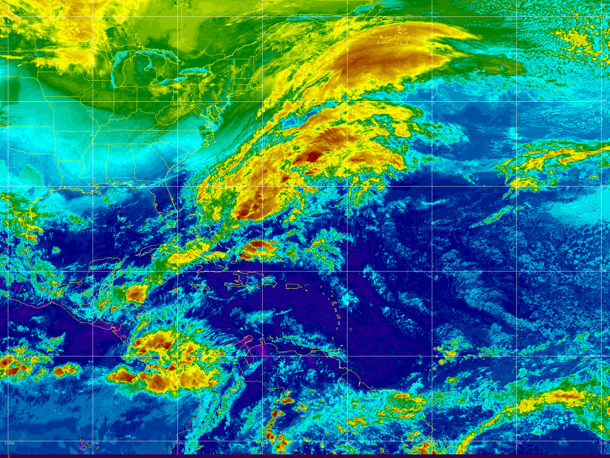
This IS the CENTER of BARRY


Wide view of the weather associated with Barry.


Tropical Storm Barry.
Taking up most of the Gulf of Mexico.
Trying to strengthen.
From the blog post earlier today.


Compare advisories and track.
Barry moved .3 W in six hours.
Forecast movement will be 5 MPH . . .
Some models show Barry bobbling around there for days.
Others show different solutions.
We are entering into Spaghetti Models territory


Why are they beginning to go crazy?
Because Barry is barely moving.
Movement impacts track and intensity.
We need to stop and breathe for a minute.

If you are in the Cone or near the Cone...
If your local NWS says you will be impacted in some way.
Prepare accordingly.
But NOTHING is LOCKED IN with this storm.
Not until it becomes a full whole round storm.
Not until it moves more than 5 mph.
Not until it intensifies.
Read my previous discussion on Earl 1998.
This may look worse than Earl.
And I know a few forecasters there that thought ....
...that nothing would ever look as bad as Earl!

Maybe Barry will surprise us all.
The BIG surprise may be TORNADOES.
Once inland especially in areas of elevation...
Tornadoes may spin up everywhere.
And remember as Barry began over land...
...Barry may look better over land.
I have seen that happen more than once with similar storms.

The reality here of Tropical Storm Barry is that the NHC is erring on the side of caution to protect lives and help people secure their property in the path of Barry. And, to be honest when people here NEW ORLEANS everyone perks up the way they do when a Hurricane looks like it's wants to do South Beach and people here MIAMI. Suddenly everyone is interested in what is going on with Barry and to be clear it will mostly impact small bayou towns and back woods sort of places that you never hear anything about. And, really God Bless the Cajun Navy because they are already gearing up to go out after Barry makes his move... to help rescue and save lives.

Low lying areas are more prone to flooding and and there could be much flooding after Barry moves towards landfall. Should Barry make continue crawling along to the West and impact the borderlands of the Sabine River area know there's a huge swamp there, bayous and backwoods and it's pretty much the same landscape you find along the Central Louisiana coastline and inland a ways. I still think the Vermillion Bay area will feel Barry however unless and until when Barry's eye tightens up Barry is a whole mess of weather moving slowly, gathering moisture and at some point some steering current will catch it's attention and grab it.

Until that happens take any and every model with a lot of salt. I don't mean just a bit of salt, I'm talking more than you would use to salt the rim of a Margarita!  Why you ask? Because if a storm like Barry dawdles too long it misses the doorway to the North and a door can slam shut and a new window will open eventually. Also when you have a storm the size of a double wide on a highway it's harder to turn and it moves slower than if it wraps into a neat little borderline hurricane and moves along zippy like as a 2019 Toyota Camry. Barry is never going to be a Lexus so let's go with a Camry; my best friend drives a late model Camry and she's afraid to take it very far and it needs work but it's a good car all in all.

Use these sites. Go to the movies. Stimulate the economy. Breathe and take a look at Barry tomorrow morning. Unless you live in warned areas then act accordingly. Here are some links you may enjoy using.

www.hurricaneharbor.blogspot.com
https://spaghettimodels.com/ check out his Facebook Page Lives.
https://www.facebook.com/mikesweatherpage/
https://www.windy.com/
https://www.tropicaltidbits.com/ Use his satellite loops and model links.. listen to his videos.
https://www.aviationweather.gov/satellite/plot?region=mgm&type=wv&date= play with it..
https://earth.nullschool.net/
www.crownweather.com
www.flhurricane.com  has a good message board and many links.
www.hurricanecity.com
https://www.nhc.noaa.gov/satellite.php
https://www.star.nesdis.noaa.gov/GOES/sector_band.php?sat=G16&sector=gm&band=09&length=36

Long link...great site play with it I like it better than other popular sites.
https://weather.cod.edu/satrad/?parms=continental-southconus-ntmicro-96-1-100-1&checked=latlon-map&colorbar=undefined

As for Invest 93L
It's unique to have a system in the MDR it's a sign of things to come.
Stock up now on hurricane supplies in FL, GOM, SE Coast... don't say I didn't warn ya..


I'll be back when there is real new info.
I wanted to leave you with links and loops.
Thoughts and realities.

I was a bit silly earlier and that's good.
The previous Live Blog is GOOD.

But this is the basic down to earth honest facts.

Keep watching...
Besos BobbiStorm
@bobbistorm on Twitter and Instgram.

Ps.. If I wrote long details of models and discussion it would be wrong.
Until Barry really wraps and picks up speed and moves.
Every model is open for discussion.
The NHC does it's best.
But they may be serving pasta for dinner the next few days.

I'm serving BBQ Sloppy Joes to my husband.
And Salad of course...
And dessert but I'm not telling what dessert is ;)

Again expect surprises with Barry.
You thought you were going to get Jimmy right?


Wrong..... same song tho...


For Invest 93L
https://www.tropicaltidbits.com/sat/satlooper.php?region=eatl&product=ir

Labels: , , , , , , ,

Thursday, October 26, 2017

Philippe? Just Nasty Weather? Are You Wearing Boots in Miami This Morning? A Look Back at 2005 Hurricane Season... How did it end?


A look close up at the Invest.


Something there...

Invest 93L in motion below

rb_lalo-animated.gif (720×480)

I know it doesn't look like much today.
You're probably tired of hearing about it.
NHC has odds at 40% at 8 AM.

rb-animated.gif (720×480)

Wider view shows the whole story.
Note convection in EPAC as well.
(That's foreshadowing...
...keep reading)

Let's go further out.
Everyone is so into black and white ...

sat_wv_east_loop-12.gif (640×512)

IF anything forms it's set in stone where it goes.
IF it really develops.
Otherwise it could linger longer in the Caribbean.

Models Invest 93L


Let's go deeper into the models.

GFS


Starts to form a closed Low.
Front swoops down.
Scoops "it" up.


Whatever forms moves through the Straits ... comes close to Florida or just stays off shore and joins up with the descending Cold Front (the next one not this one obviously) and plows it into the NY and NE area (that includes the coast of NJ) creating travel delays, flooding possibilities and downed trees that will lead to downed power lines that will lead to power outages. It's a mixed bag of annoyance, it's not a hurricane racing up the Eastern Seaboard, but it is an early winter storm or October Gale (what is in a name really???) creating lots of weather. The above scenario is according to the GFS model shown above.


Let's look at the EURO... The Euro forms a closed Low in a similar place and then like a bad advertisement for Las Vegas keeps what started in the Caribbean in the Caribbean, yet another Low pops up and catches the same frontal system and plows into the same coastline as the GFS above. For an added bonus, the always dramatic Euro, develops another storm in the EPAC. It then moves the "L" North into the same region that the GFS does above.


In between the GFS and the EURO there are many other model solutions that all do similar things. The point is it is not a name in this case but the actual "weather" that could impact the multitudes.  Many models show a brief period as a named storm and then it merges with the front. Some show it crawling up the Florida Straits (sorry Florida Keys) others show it crossing Cuba... most want to take it NE up the coast. Other models want to keep it home in the Caribbean. Some models split the energy in multiple directions. The end game here for the USA is that an area from the Mid Atlantic North into New England will have dramatic weekend weather and they need to be properly prepared if that does verify. IF it comes close to South Florida or any part of Florida it will be discussed in great detail with sadly great hype. Everyone is a bit over exhausted from this hurricane season. For now people in South Florida are enjoying wearing boots and whatever cold weather clothes they have ... however...the same pattern that brought them this week's cold front will bring them the next cold front and that might have a tropical storm trying to hitch a ride North. Time will tell.


A voice I respect is Larry Cosgrove you can follow him on Facebook.
https://www.facebook.com/larry.cosgrove

Jim Williams weighed in on Facebook this morning... 


Miamians be like "it's so cold" this morning.

NYC NWS Forecast for this weekend.


(as always forecasts are subject to change in real time)


Some have gone out on a limb...
...and predicted this is the last of the Hurricane Season.


Again I say ... time will tell.
Cold fronts usually change everything.
But often odd things pop out in Nov and Dec.
Let's look back at another similar year.
Or will Philippe become Porky the Pig?

Let's look at some weather history.
2005 Hurricane Season Map Below.

track.gif (640×512)

I want to look back a bit at the 2005 Hurricane Season. This 2017 Hurricane Season has been compared to 2005 often and the name list itself is the same, albeit missing names like Katrina, so it almost seems redundant or Deja Vu to look through this list of storms. Nate, Jose the 2017 names resonate in our recent memory and the names Maria will be forever retired from the list of names used for the Atlantic Hurricane Season. 2005 for many ended with Wilma, yet the season went on with a progression of named storms that really went no where, popped up out of nowhere and most do not remember their other than the oddity that we ran out of letters in our Alphabet and had to borrow from the Greeks names to use. Many of those "storms" look like punctuation marks on a document that's being edited more than real tropical storm tracks.

https://en.wikipedia.org/wiki/2005_Atlantic_hurricane_season You can slowly plow through the multitude of storms that traced patterns around the Atlantic Basin causing misery, destruction and death. Years like 2005 are few and far between and this past year we have seen a similar slew of destructive hurricanes; many memorable in similar ways. 2017 was more intense in actual long lived Category 5 Hurricanes aimed at islands in their path vs way out in the middle of the ocean somewhere just an asterisk to the ACE numbers for the year. 2017 is not yet over, it's winding down and still a work in progress but we hope and pray the destructive Category 5 Hurricanes are done forming this year and we will just get some random storms that form out at sea and move somewhere else as weak, wandering remnants of tropical weather.


Now let's look at 2017 so far......

track.gif (640×512)

I'll enlarge the traffic jam westbound ...


Remember forecasts verified for a busy season.
Forecasts verified for a strong high...
Will winter forecasts verify as well I wonder.

Besos BobbiStorm
@bobbistorm on Twitter

Ps 


Labels: , , , , , , , , , , ,

Monday, August 28, 2017

UPDATED - TS Harvey, Invest 93L CV Wave, PTC10 Off SE Coast Headed to SC, NC Possibly TS IRMA Later Today... TORNADO WARNINGS CURRENTLY ONGOING

Harvey 

Just goes on and on and on.
Yet he will eventually move on.
Exhausting tragedy.


Still a Tropical Storm
Still a Flooding Problem.

And off the East Coast of the US..
That bright red area is PTC10.
What was once Invest 92L

PTC10

There is intricate discussion going on as to whether or not this system will eventually become a Tropical Depression or Tropical Storm. Yet....it has 40 MPH winds, remember that. Suffice it to say a storm by any name is still a storm and there is stormy weather moving en masse along the East Coast of the United States. So let's focus on the weather and not the discussion of the name. The winds are there for Tropical Storm strength as it currently has 40 MPH winds, however it's circulation is not complete. There is heavy rain along this stormy patch of weather and some possibilities of flooding in areas in Eastern NC that are prone to flooding. The beaches have high surf and rip currents and it looks...well...very stormy. Here In Raleigh there is a constant, beautiful breeze with light rain. Feels tropical ... feels a bit like an early Autumn Cool Front and then it feels tropical again. As it moves up the coast beyond the warning areas the beaches along the Del Marva Peninsular should see storm whipped surf. Nothing like what it could been had the shear enhanced by Harvey had not been there to create problems for 92L (PTC10) 


And, then Labor Day Weekend comes with no big storm threat along the East Coast. That may happen later from Invest 93L in the Atlantic but this week enjoy life and have a wonderful Labor Day Weekend.


From Discussion below.


93L Models - Discussion.
80% chances in 5 days.
40% in 2 days.


rgb_lalo-animated.gif (720×480)


Has a nice spin.

rb_lalo-animated.gif (720×480)

Really too early to tell where it's going.
For now WNW... maybe NW..
Then maybe bend back to WNW or W.
We have lots of time to watch.

Below is a comparison.
Compare and contrast Harvey and PTC10


Both with low intensity forecasts.
Tropical Storm...
Then a ticket out of town..
PTC10 .. ? Irma sooner.
Harvey later.
But they will go..


Good solid discussion from the NHC. A dry slot visible on water vapor imagery shows things are beginning to happen regarding Harvey. Yet, he has not started to make his move. Winds will be felt in areas where people are trying to put their lives back together close to the coast where Harvey originally made landfall. This can be seen on the water vapor loop I am posting from LSU below.


Watch the blue air (dry)
moving down around Harvey.
At some point...
....he will move.
As the cone shows above.

latest_wv_loop.gif (535×440)

Regarding PTC10
Cone and discussion the same.
Waiting for it to pull it together.
See information below.
Thank you.

irng8kml.GIF (2000×1500)

Similarity between Harvey and PTC10 above.
Waves out in the Atlantic evident.
Stalled frontal boundary.


Headline from the NHC.
TS Harvey.
PTC10


That link shows a tornado warning currently.
Lake Charles as shown above.
New Iberia and St Marys Parish as well.

 The basics regarding PTC10 are as follows. Currently it's awaiting better organization and stronger wind speeds for an upgrade to TS Irma. PTC10 is dealing with shear from the outflow of Harvey and close to a stalled out frontal boundary. It has a small window of opportunity and should it take that opportunity it will become Irma. If not it will be absorbed into the larger system that will move rapidly off the East Coast and take it out to sea. Even then it will enhance the power of that overall larger system and bring strong weather in it's path. You will start hearing words and explanations on what is Extratropical and the word Baroclinic may get bantered about by meteorologists. Don't get confused with names, a storm by any name is a storm. Plain and simple. Plan accordingly.  Note below an image posted by Dabuh who is famous for his surf and weather reports. It's a reliable product. It shows a Possible Tropical Cyclone.


Currently a sort of one sided STORM system.
Cradled in the curve of the Carolina coastline.


This is the area that will be impacted by PTC10


The cone is wider.
That's a forecast coordinate.
Cone below from earlier.
Nothing new there.


I want to be really clear here. PTC10 is NOT Tropical Depression Ten. They are not the same the P stands for POTENTIAL and most likely it will become Irma, however I have seen posts online by many who should know better who simply say TD10. Yes, details matter. Words matter.

As for Harvey, it is currently a Tropical Storm and forecast to stay a Tropical Storm. That can change as always so stay on top of it if you or loved ones are in your path. As Houston is the 4th largest city and much commerce goes through that large area this is an economic mess for many as well as a personal tragedy for those in it's path. The NHC puts out a good product that is shown below. It's the basics, pictures, words; more words than Twitter and Snapchat but concise and well done.


See this image below:


When NHC links to the NWS.
Follow those links.
Links now show NWS Lake Charles.

Note the heavy moisture is moving East ..

sat_ir_east.gif (640×512)


My thoughts from last night remain the same, you may want to read them below.  Anytime a system is back out over the water in enhances the moisture and the misery. The loop below shows how that moisture is being funneled up and over the area making TS Harvey look more like a Stationary Twister on satellite imagery than a true Tropical Storm. The winds are there and it has a viable center, despite the odd signature on satellite imagery.


latest72hrs.gif (947×405)

Next we have Invest 93L
Introduced this morning to the mix.


Westbound.
Not going to discuss models.


From Spaghetti Models.

As soon as they are all out.
Mike will put them up.


He also has a specialty page for Harvey.


There's lots of time to discuss 93L
It's moving westound.
You can connect those dots.
Threatens land or goes out to sea.

Leaving you with one thought.
Other than please donate what you can.

Remember September.
September is 4 days away.
Hurricane Season.

Next name is Jose.
After Irma ...comes Jose.

This is a huge story.
According to Amazon news ...
Image from the Washington Post below.


My thoughts are with you Texas. My prayers are with you. I've donated to the http://www.redcross.org/ and I hope others do as well.

As for the rest of you in Hurricane Country... Remember September. Hurricane Season is just ramping up. Get a plan you can execute and be realistic about the threat this Hurricane Season may pose to your particular place in the scheme of things. El Nino is no longer in charge and Hurricanes are back in style again.


Besos BobbiStorm
@bobbistorm on Twitter
I'll update at the top throughout the day.
Or start a new post if NEW possibly.
Check back often for updates.
Thank you..


http://hurricaneharbor.blogspot.com/2017/08/ts-harvey-reborn-tropical-storm-again.html

Labels: , , , , , , , , , , , , , , ,