Hurricane Harbor

A writer and a tropical muse. A funky Lubavitcher who enjoys watching the weather, hurricanes, listening to music while enjoying life with a sense of humor and trying to make sense of it all!

Monday, August 31, 2020

UPDATED 11 PM............15 Still 15. Water Rescues in Raleigh from Heavy Rain -TROPICAL DEPRESSION 15 FORMS OFF THE CAROLINAS ---- Dueling Invests..........Tropical Trouble in the Tropics But Nothing Compelling or Major... Waves off of Africa And The Seasons About to Flip So Watch Out. Meteorological Fall Brings Trouble and the Equinox Massiver Hurricanes Usually. Oh and the Story of Victor and Ella.


There's a front........
......it's really part of a frontal system.
But I'm not going to go there...
It's got a signature on Earthnull.


Meanwhile in North Carolina...
...not specifically connected.
But all the weather here is connected.
After the "Cold Front" passed thru...
...it came back as a warm front.
Stalled ISH but moving slowly.


I kind of feel like we deserve a name or something.
While smaller than TD 15
We have way more energy going on...

Heavy convection.
Some areas had 6 to 9 inches...
just from today/tonight's rain.


So it stopped raining.
Cooled off but no breeze.
Then it began to rain.......
........and it hasn't stopped.
I live in an area not prone to flooding.
But as Raleigh has steep hills, dips...
... some areas flood!


Water rescues going on currently...
...in some areas.
There's been Flood Warnings All Night.


Okay we have Tropical Depression 15 off the East Coast from Invest 90L that is forecast to stay offshore and become a Tropical Storm in the near future. I would go to the beach and see how close it gets tomorrow, but I have a funeral for my friend Victor in Raleigh so guess I'll catch the next named storm round these parts because I'm guessing the third time is the charm for really being impacted by a tropical threat this year. So 15 will be a Tropical Storm in theory Nana unless the NHC uses that name randomly in the Caribbean ... 2020.  Meanwhile I was outside watching a wild line of thunderstorms come through fast and furious and I do mean furiously. Trees, bushes don't usually bend in Raleigh and it's not Miami where you get sheets of rain and squalls, but today's summer thunderstorm was wild.


It may not look like a lot to people in Miami.
But for Raleigh this was wild and intense.
I'll update the blog later...
...I'm soaked :) the wind was swirling everywhere.
Loved it.


And now it's gone as if it never happened.
Except for the huge puddles.
Stay tuned.


2:30 PM

I feel like we are at this scene in the  movie...
Dueling Invests.


This is a form of the water vapor loop.
One of my favorites.
99L in the Caribbean looks stronger.
More intense water vapor wise...
90L has a great spin on the visible imagery.

Models:


Majority still go with Westbound.
But a lot can happen still.
It doesn't even have a name yet.

There's always that one model that breaks from the pack.

Both Invests there's that one odd model.
Look at the bottom right of the models.


Down here...see tracks here?
Hmnn what's that?
One of the African waves?


Got out a bit. 
Went to TJMAXX
Enjoyed the "cooler" warm weather.
Less humid tho moisture is moving in.

I'm feeling like it's a duel of sorts....
...between 90L and 99L
99L was first...
..then we start over at 90L
All up to the NHC
They make the call.
Will they do it today?
Stay tuned.


Further out by Africa....
...a wave comes off strong and spinning.


2 of many.
My friend always says take the 2nd in the set.
We will see in a real time.


To decipher this colorful game of Tic Tac Toe.
The 2 red dots are at 70% and 80%
Yellow Dot is there to watch for slower development.


So let's break this down.
The low rider stays lows.
Could it pull North?
Maybe but most likely not but watch..
The Carolina Cruiser is cruising along the coast.
A site seeing tour, socially distancing..then out to sea.
By Africa we have two waves.
On is swimmming WNW.
The other has not left Africa yet.
Nothing screaming CAT 4!!
But two will probably get a name.
Unless the NHC starts walking down their chances.
70% Carolina Coast.
80% Caribbean Cruiser
As of 8 PM

hiatlsat_None_anim.gif (768×496)

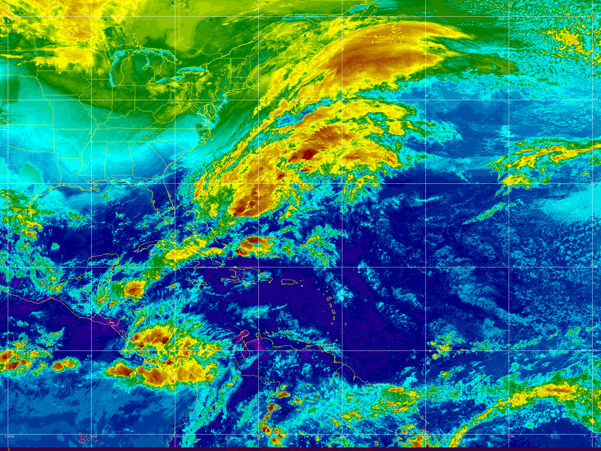
Yes, I do love this map and probably the main reason I love it is that it looks like a map. I do love maps. And, if there is anything here it sniffs it out and it's true to form so you can see the whole basin and if any storms might be trying to form. It doesn't show the intense detail of other newer sites but we don't have anything wild to zoom in on today so this is my default loop. So what does this loop show to the lay person who hasn't spent their life studying meteorology? It shows a wave train that's coming from Africa and it shows frontal boundaries moving off the East Coast into the Atlantic and what you can't "see" is the strong High the waves are being propelled South of as they move towards the Caribbean.

There are no huge hurricane threats today, however something could form if it gets strong enough for the NHC to tag it as a Tropical Depression later today considering the odds and the color of the crayola. Isn't it funny how everyone immediately remembers their favorite color in the big 64 box of Crayola. My cousin Brian always had the 64 box, my mother decided 48 was enough but my Aunt would go all out for the 64 box of crayons. All that bartering at friend's houses as kids wanted to trade off the yucky color for the one they loved. These are Invests, they are not the color you will always remember but they may work fine to color in your emotionally healing coloring book. Apparently in 2020 people are coloring their way to therapy or trying to overcome boredom so mentioning it. Supposedly it's good therapy.

What do I think about the tropics?

Later this week we hit Meteorological Fall and Fall really begins if you are like me and want Fall to happen sooner rather than later.

Then in 3 weeks we have the actual Fall that comes during the equinox when hurricanes like to happen and the seasons begin to collide. Indian Summer sets in, it gets very hot then a strong front pushes it's way down and at the same time waves that rolled off of Africa move towards the Low attached to the fronts and suddenly the East Coast is in play as storms lift more and try to avoid the Caribbean. While this happens the Caribbean really boils and the waves that never formed mix it up with convection off of Columbia and turn into huge SW Caribbean monsters and we worry that they will pull North towards the previously mentioned Cold Fronts.

This is the real season... the mix of the seasons and this is why in Colonial Days when people kept weather logs in the colonies they referred to hurricanes as Equinoxal Storms. They didn't have satellite imagery but they knew the door was open to a real hit from a storm that happened near the Fall Equinox. That's sort of what I call Captain Climo. They didn't have satellite imagery but they knew from the logs that were written before them that they needed to worry in September going into October for one hard last slam from a tropical system before true winter set in.

What does that mean TODAY?

I'm concerned personally on the region from South Florida to Charleston personally as they have been extremely active with lightning storms, high heat and humidity and growing up in Florida that is what we call Hurricane Weather. Will something pull WNW and feel the tug of an early front and roll across Florida somewhere or curve gracefully away towards the Carolinas or will one of them grind it's way like Matthew up along all the coastal beaches, causing flooding and slam into South Carolina or the Outer Banks before moving fast up the coast clipping Long Island? Maybe ... it's possible.... it's also possible the Northeast is in play when a door opens briefly for a tropical threat making landfall vs clipping Cape Cod after clipping Long Island and going up into Canada. 

What I am saying is we are beginning to change gears here away from what I have sarcastically called "ACE FOR A DAY STORMS" that form close in, flare up and make landfall and get a name and cause pain for the people trying to clean up in August Heat without electricity and bits and pieces of their lives tossed about which is really sad and yeah I've been there it's not a pretty place to be it's a make it through the day the best you can and pray there are better times coming.

In Miami post Andrew it was a hot hell with no air and no running water but daily showers provided by Mother Nature and no electricity for weeks, no cable TV for months. After Wilma we had cool air and we could sit outside around a campfire the kids made cooking off thawed out turkeys and enjoy the stars in the dark night as no one had power but we all had a cool breeze from our first early cold front.  Again words matter..........we had an early cold front.


Here's the wave train coming off of Africa.
Like contestants in a contest lined up.
They are rather close together.
Being close that's a negative.
One of the few negatives in the game.
But one or two will show they are the real thing.
The others will fade away.

I'll update later today if the NHC upgrades.
I'm not saying GOM doesn't have to worry.
They do but anywhere a cold front sets up....
..and the high shows a weakness.
A hurricane can make landfall.
And talking real hurricanes September/October.
And then...yes Virginia we will have Winter!

Give to charity those hurt by Laura.
Make sure your hurricane kits are ready.
Make sure you have a plan if you need it.
And enjoy the beauty of the day.

Besos BobbiStorm
@bobbistorm on Twitter and Instagram.

Warning long personal Ps today.

Ps I had a friend pass away on Saturday and no it wasn't Covid (everyone asks these days) it was Old Age issues that had been dogging him for the last few years, he was in his 80s. He was one part of a couple that I met that I loved dearly upon meeting them when I was dating my now husband back when and they would come for dinner often and they were beautiful. They were an older couple, a second marriage for both of them though hard to imagine they had lives before each other but they did as they were extremely devoted to eachother. Vircor, who passed away on Saturday, seemed like an Old Southern Gentleman but he actually was born and raised in Brooklyn and attended a Yeshiva and eventually ended up Down South where he was a professor of sorts and after his wife died and telling eveyone he wasn't going to get remarried he met Ella at a dinner party a friend from the University invited them both to so that they could meet.... to and yes Victor fell in love with Ella and really how could you not? She was an artist, and one of the sweetest souls I ever met in my life... old Southern girl from the Carolinas, she coverted and learned how to make Kosher Crab Dip with that fake crab that most your regular Chinese restaurants use ironically and she was just awesome. For a while he had a dream to own a restaurant in Emerald Isle and they moved to the coast when he "retired" and it was an adveture and they loved Salter Path (check out a map of Atlantic Beach) and after a while they gave up the restaurant and moved to Raleigh where they became regular members of the Chabad Community.  Victor loved Israel, Ella loved Southern things and anything that Victor loved and painting and teaching kids to paint and watching after Victor and I like to think of Victor back with Ella now as he passed away Saturday after telling my husband on Friday before the Jewish Sabbath when he spoke to him on the phone he "wasn't afraid to die" and I guess we both knew that was going to happen soon but so Victor to let him know he wasn't afraid.  But they lived extraordinaty lives whether they were at the beach or going to a political convention, I think they may have attended an Inaugural Ball even or trying to make a dream come true and knowing when to give it up and move on to another dream.   Miss them both but they welcomed me to Raleigh and I've felt welcome ever since. My dining room chairs are from Ella ... they had them down at the coast and I believe she had them a long time longer than that... I don't have any art of hers yet I have hand written notes filled with recipes for things I asked her how to make and she lovingly wrote cards with details carefully filled with love. They lived a life extraodinary. 


That's a picture from 2013...
...like to believe he's holding her now.


That's what their ocean looked like....
...they lived their dreams.


I only have the best of memories.
May you all build a life of such memories.
Yes, storms happen... 
...don't focus on the bad stuff.

Victor used to tell me that of all the people he counseled... 
...none were upset about the future but upset about the past.
In one way or another he was right.
Find your focus.......
....go after it.
Live your dreams.
Accept your failures.
Keep on living.
Don't be afraid of death when it comes.
Live a life extraodinary indeed.


Sunday, August 30, 2020

Updated 2 PM INVEST 99L 80% Chance of Stealing the NANA Name from the Area Off the SE Coast....70% Red Off SE Coast. 3 Waves ....4 Areas to Watch on a Quiet Weekend.


You can see a bit of a spin in both areas now RED

GOES16-CAR-13-1000x1000.gif (1000×1000)

Here's a link to the site below.
Mike links to on it SpaghettiModels.
They are great.


Old graphics, it's as if no one can keep up with it today as it's being studied for development.`If it develops sooner rather than later it will get the NANA name not the system off the SE coast that actually is doing it's thing as expected. The big question many have here is does it continue West towards the Pacific or lift just enough to get into the Gulf of Mexico. Long ways out now as it just began it's official trek this morning. 

So much for a quiet day and a quiet week. That's why I don't listen to "talk" and pay attention to "click bait" promising you all sorts of things. Models show interes often when something develops and sometimes models can predict development; it's a science we are getting beter at it but it's not perfect.  So NHC upped the chances at 2P to pretty much "stand by for upgrade" if you know what I mean.


So something changed.
A bit earlier than expected too.
NHC upped the ante on Invest 99L
Oh and we now have 99L


Actually low, closer to South America than looks.


Currently in low shear area...
..if it can slip South of the stronger shear.


Early models.


***

FROM 8 AM before new Invest.
And upgraded yellow to orange shown above.


Graphic of the day.
70% over the next 5 days off the E Coast.
Slides along the coast and out to sea.
How close to the coast?
We'll see.


A bit of low pressure and a frontal boundary.
Gets you red on the NHC main page.
If it gets very close to the coast..
...I may go to the beach to see.

irng8kml.GIF (2000×1500)

You can see the area along the East Coast.
Westbound waves.
What you don't see well here is SAL.
But you see it on the satellite image below.


You can see the waves tucked neatly below the SAL
Riding westbound under the High Pressure.
Even in black and white it shows up well.


Shows up very well above.
What's up with that?
Happens sometimes.
Squahes the wave production a bit time wise.
But past the surge line they flare up.

hiatlsat_None_anim.gif (768×496)

In motion you see the wave train.
And the lead wave flaring up.
And the area off the SE Coast.

See SAL squashing early actually is not great for our side of the world, as waves that come off spinning and have a chance to develop fast and lift for in latitude early on become fish storms moving over the open Atlantic. Yes, some storms come off spinning. I was talking tropics to my son the other night and told him to Google Hurricane Donna responsible for a plane crash before it even left the Cape Verde Islands (they were called that then) yet when dust deprives us of Fish Storms, we often end up with them in the Caribbean the way Camille formed later rather than sooner or Laura as well as East Coast Iconic hurricanes with names that are retired. So the SAL comes under the category of "that which doesn't kill us only makes us stronger" so keep preparing those hurricane kits. 

NHC gives the lead wave low chances.
They aren't impressed.
People in the Caribbean are watching it.

2000x2000.jpg (2000×2000)

I'm watching it too!

Good Carib site to follow.
Deep in data on the Caribbean.


Live reports from the Carib

And as always www.spaghettimodels.com
Lots of links, loops and zero carbs.

As for Laura

I'm not going to go long on Laura, the reality of what happened is obvious and there are images all over the web. There's some incredible imagery and information on the link below.


Everything from images as the one above.
And before and after as seen below.


Undersatnd you don't need a strong Cat 4..
..to do that along the coast in a hurricane.
Any Major Hurricane will wipe a beach town away.
A storm surge is unrelenting.
It's the sea trying to reclaim the land.
Power of storm surge in Cameron, LA.


As for Lake Charles built inland...
...it's all about the power now.
Currently down that way it's all about the power..
First comes power needed for clean up...
...and trying to get back to some sense of normal.


I'll be back later toady.
I'll put up some models...
..for now have a good weekend.
Enjoy it as who knows what will show up Labor Day.
Maybe nothing but don't waste a good day waiting.

Besos BobbiStorm
@bobbistorm on Twitter and Instagram.

Ps the song that comes to mind today.


Saturday, August 29, 2020

3 Areas in the Tropics Being Watched. Quiet Yet Possibiliites for Later This Week...


A loop shows these areas in flow in real time.

hiatlsat_None_anim.gif (768×496)

Obviously the wave train is active.
Choo! Choo!! Ya know.
Combo of convection off Carolina Coast.
Always areas to watch in late August.

I'll update on Sunday at some time.
But for now...
...stock up your hurricane supplies please.

Especially Florida up through the Carolinas.
And along the East Coast.
This season is not just about the GOM.

Sweet Tropical Dreams,

BobbiStorm
@bobbistorm on Twitter and Instagram

Got this stuck in my head....
...might be someone's fault.
you know who you are.
Crazy busy hurricane season.
Next storm up in the N storm.
NANA in late August....


Friday, August 28, 2020

Yellow Wave 30% Orange Wave 40% Out in the Atlantic. The Day After Laura Charged Through Louisiana With Cat 4 Winds.


2 PM 


2nd wave higher chances.
Forecast to sit for a while and simmer. 
40%
Lead wave, lower 30%
As for Friday late in the Afteroon.


Both circles are currently at 30% Friday morning.
Looks scary but it's not forecast to develop for a while.
If it develops and yes some models show something out there.


The above image is from Windy.
Thursday, six days away.
I like this filter as it shows convection.
If you get an attempt at circulation...
...and you got convection then I'm interested.


Basically it's just waves and wondering.
Nothing nasty out there today.
Check back Sunday or tomorrow if you want.

Views of damage from Laura.


You can follow them online, they are good.

Laura from start to landfall.


A last image of Laura before the radar was gone, gong, gone.


Some thoughts below and then a song for the road.

hiatlsat_None_anim.gif (768×496)

Some models take the wave that develops faster...
...up into the Atlantic.
But I don't trust early models.
So know they are there and do what you can now.
Do hurricane preparation and take a Labor Day Staycation.
This is the last offical weekend of August...
... summer almost over, September around the corner.

Mike's talking on Facebook Live that I actually watch on YouTube now. Isn't a world with options wonderful? Moves fast and clean on YouTube and people chat and you can read comments in real time so that works. He keeps trying not to say "worrying on the next wave" vs "watching the next waves" because really we are watching the next waves because we are worrying on the next waves.... and so we should be. But, in truth storms often pop up somewhere close in even faster than it takes for the waves we are watching to get close to our side of the world. Ususually but
not always after a Major Hurricane the environment is quiet for a few days, so enjoy the quiet. Lord knows those down in Louisiana need time to clean up what they can before another hurricane cone shows the Gulf of Mexico in the middle of it.

And, many on our side of the world are spending this weekend cleaning up along the coast of the Gulf of Mexico after Laura left a path of debris and destruction that was only seen after dawn allowed us to te see learn the horrors that happened in the dark night of Hurricane Laura. Always hard watching nightime videos from storm chaser friends at in the early morning hours of 1 AM because the sky is dark, lit up only by exploding transformers and we mostly hear the sound of everything flying in the wind. Come morning in the daylight we get more images and videos where we see what it was that went flying in the night. And, often it's not what we thought we would see. Yes, there was flooding but the storm surge was not as historic as was advertised but the wind damage was horrific. Mike, who is a very senstive guy beneath his friendly fun style was extemely upset as one of his site's followers who lived in the path was worrying on storm surge asking him questions, and yes they got out and went to higher ground but when they returned it was the wind that tore at their house and ripped the second floor off leaving bits and pieces of insulation hanging at odd, broken angles and again you worry on the wind and then you get flooding or you worry on flooding and then you get the wind damage. This part of the world is used to bayou flooding but it's not very used to the damage seen only from a strong Major Hurricane.

There are places along hurricane coast that somehow get "lucky" from the big ones usually; yes history has hurricanes that made landfall in the 1700s or 1800s or back in 1921 as Tampa had a rare Major Hurricane hit a hundred years ago but generall in this part of GOM they get picked up by a front further to the East and head for Florida or they get pushed by the High further west to Texas but Laura went where Laura wanted to go always. Horrible destruction and I'm not going to show tons images here this morning because there are images and video everywhere so just giving you my thoughts this morning and one video below. Add in surprising to many was the huge chemical fire yesterday morning that didn't surprise me because that part of Louisiana is loaded with chemical plants and other various similar industries. Leaving the one video below, really sad and can only hope and pray they get as much documented, get their claims in and poperty repaired and find what ever they can that remains because September will add more landfalls I fear to our list for this year and resources to rebuild will be stretched even thinner.


So leaving you with the song below, very dark and intense and kind of perfect for this morning when people are watching the destruction that Laura wrought and wondering and worrying on what else is out there. Apparently that's all my family WhatsApp Group was takling about. If you haven't heard about the new Batman movie feel free to Google "Twilight Vampire Batman" and you'll hear all the news on that one.

Yes there are waves highlighted as I said out there and they are moving Westbound under a HUGE HIGH and they may devleop faster than the models imply but currently the models don't show anything trying to wrap until Thursay a good six days away, but I'm not a big fan of models but I sure do watch them. And, watch for close things that can bubble up from old waves and areas of consistent convection that persisted long enough to try and spin up close in somewhere. Even though it's almost September you have to always watch close in at the tail end of hurricanes, fronts and trailing troughs.

My advice.
Give money to a charity you trust to help rebuild in the areas smashed up by Laura and pray for the people whose lives were torn apart. And, then make sure your hurricane supplies and plans are up to day. And, then go out and enjoy Labor Day Weekend if your beach was not destroyed by a hurricane and the weather is good and get some fresh air and a strong ocean breeze and give thanks for what you have. And it's my advice that since we have a lull in the tropics right now, don't wait to go away next weekend on a busy holiday vacation but if the sun is shining on your beach or lake or favorite mountain view get out there now and enjoy it this weekend before the crowds as there's always a chance we could have tropical problems down the road. If this year hasn't taught you anything it should be not to put off for tomorrow what you want to do today!!

In the world we live in this unexpected, crazy year of 2020 we need to take time to appreciate the good things, because we see so much negativity on the news and images that scare us as well as the political pandering and maneuvering during a world pandemic that has taken away the lives of people we knew, worked with and loved so really you have to give thanks for the good things be they seemingly as insignificant as you learned how to make a fancy bread or your tomato crop was bountiful and so learn how to make salsa or give some away. Just have a good day and help out those that you can if you can. Have a good weekend, I'll update the blog if the NHC ups the percentages for those faraway distant waves.

Besos BobbiStorm
@bobbistorm on Twitter and Instagram


Thursday, August 27, 2020

Cat 4 Hurricane Laura Made Landfall Cameron Louisiana .. A Look Back, Ahead and Where Are We Now? 20% Yellow Circle in the Distant Atlantic.


This is Laura currently.
Laura doing Louisiana.


Laura Over Inland.
New Yellow Area debuts at 20% Yellow.


Laura made landfall at Cameron Louisiana.
Then it moved towards Lake Charles.


Official NHC wordage above on landfall.
Using this cone to show the cities in the path of Laura.


The projected track of Laura and her rains.

allfcsts_loop_ndfd.gif (799×559)

It won't be a hurricane much longer.
But it will bring heavy rain, flooding possible.
They seem to have downgraded it's inland potential.
It's one of those subtle things you notice.


The immediate rain concerns from Laura above.
If you are in those regions watch your Weather Apps.
You can always tell tropical rain from a cold front.
I notice that in Raleigh often, rain associated with a storm..
...often a far away storm feels and smells different.

After moving here years back after getting remarried my husband and I were walking to a friend's house on a Saturday Shabbos afternoon and a fast moving squall came through out of nowhere from a storm that was down at the coast moving North of us but splattering tropical rain across the Raleigh region. We ran to a nearby Magnoila tree, and when I say a tree I mean a huge massive tree covered in huge white velvet like saucer shaped flowers that hung from the lower branches close enough to the ground to peer into their magical beauty. There was no thunder, we stood there sheltering from the heavy rain that "felt" tropical, more like Miami than what you feel up here often and yet the tree mostly sheltered us as the fast moving squall raged all around us. There was a huge, white magnoila that was at it's peak meaning close to a foot wide across easily and the scent was heavy but light in the way magonoila's smell and it was mesmering standing under the huge, old magnoila tree with a squall racing through and then it was gone as fast as it came. I wanted to stay longer, watching the rain, barely any raindrops falling through the heavy canopy and every few moments putting my nose .. my face ...down into the delicate but strong magnoila and inhaling deeply the beautiful scent. It was sort of my welcome to life in Raleigh where occasionally a distant band comes through from a storm down near the coast I discovered the heavenly scent of the magnoila blooms that I fell deeply in love with that begin our venture into our Carolina Summer. Some years they bloom early, other years late and once in a while on time and depending on how hot it is they last longer or they they begin to burn up around the edges turning brown too fast sadly in a too hot, too early July heatwave but I stay in Raleigh every year that time of year just for the Magnoilas. Then generally deeper into July and August I go South to Miami to escape the heat and hayfever that also arrives in the South this timne of year when the cicadas sing way too loudly.

I watched the coverage on multiple feeds sharing images and tweets with my kids who live in various cities around the country but all know what a hurricane is and know watching the power of a Category 4 outweighs the value of sleep at a regular bedtime and it was nice to talk to my son in Seattle who always has the best data, model displays as he created models when he was at Iowa State and my son the architect who watches from the perspective of which shelters are stronger for storm chasers and my daughter who was 7 months old in the eye of Andrew in awe of the storm hoping everyone in it's track was safe and fully informed.  My best friend who had eye surgery the day before was healing and able to see well and was watching TWC feed sending me messages. Life seemed sort of normal for our family, without the adrenaline of fear that my kids in Miami were in a Cat 4 but just watching a Cat 4 online with them instead. TWC did it's thing well, glass shattered falling like firecrackers caught in the light in the black night as everyone ran for cover; yeah that happens when you stand outside in a hurricane under a sign... real storm chasers don't do that they chose their location very carefully to make sure that doesn't happen but it does make for great drama and a visual gone wild.


Sometimes it's the little things that catch your attention or the lack of things and that's why I posted the video above from Josh's tweet he tweeted online from the eye of the storm. He tweeted it to share but not sure if anyone who has not been through a Major Hurricane can understand what he is really showing. After the raging storm, with noises all about you that sound almost like battleground noises with bombs exploding somewhere, art deco colors in the sky as transformers blow loudly, metal debris clanging in the wind as if a muscian is playing some odd instrument he crafted during the height of a storm and the song should be called WindChimes Gone Wild. The roar of the hurricane, the piercing whistling you hear especially through pine needles and metal no longer perfectly attached to a building and then the eye descends on you and really it feels as if it is descending down and spreading out around you and the noise begins to dim and diasppear and if it's a real eye, a fully closed eye then the stars come out, everything is quiet in the middle of the night except for the sound of crickets. You are in the middle of a Major Hurricane and it's so quiet you can hear crickets.   And, that is what it is like to be in the eye of a hurricane! It's a bit addictive I will admit it and after the storm is gone, despite the damage and the debris there's this little voice inside you that says "wow, I want to do that again" but the hurricane has moved on.

Adding in the reality of what real chasers do so don't send them a message during the storm if you can share their footage, the answer is no. They share what they want you to see for free in short snippets on Twitter and then they put their footage into a creative product that they sell. It's a creative product, they are creating for you a product that shows the whole story not just in bits in pieces of one wild video. Yet of all the snippets of video he tweeted this one hit me the most, not because he's dark and serious but a bit playful and poetic but because this is the reality of an eye. This was not his most violent hurricane, but perhaps having lived near by the last month or so it felt a bit more personal to him as he has had a chance to attune to the mindset of living on the edge of the Gulf of Mexico, watching storms at night and knowing any day a hurricane may blow your way.


I'm going to be offline today watching coverage on TWC and doing some things I didn't do the last few days and taking a rest from being online nonstop and updating the blog.  I will tell you there is a wave out by Africa with currently low chances of development but they may go up later in the week. It's far away and we are still watching Laura.  

Also mentioning this because it's true the new guy at TWC named Tevin Wooten was excellent with Hurricane Laura. Nice to see new young people coming up doing great work.


So that's Laura.
Today everyone has Laura stories.
This was mine.
Soon we start tracking again.
We are days away from September.
Labor Day Weekend in Louisiana...
...will be all about clean up.
Not really beach vacations.

Thank you for your comments on Twitter
And stay safe but find ways to enjoy the day.

Besos BobbiStorm
@bobbistorm on Twitter and Instagram.


The eye of a hurricane staring back at you.
They can be mean, dangerous and destructive.
But they can be soulful, quiet, spiritual and beautiful.
I always tell people it's preferable to chase a storm...
...then to have a storm chase you to your home and family.