Hurricane Harbor

A writer and a tropical muse. A funky Lubavitcher who enjoys watching the weather, hurricanes, listening to music while enjoying life with a sense of humor and trying to make sense of it all!

Friday, September 30, 2016

Cat 4 Hurricane Matthew Could Intensify More... Swirls Slowly in Caribbean Cuba, Jamaica, Haiti Under the Gun Now. South FL Needs to Watch Carefully & Bahamas.


140 MPH Cat 4 Hurricane.

ft-animated.gif (720×480)

This is what is called Rapid Intensification.
Best seen on Funktop image.

Pressures drop.
Winds go up.
Eye wall consolidates.
Sometimes Eye Wall Replacement Cycles Begin.
Eye wobbles.
Makes it's own weather aloft.


Those strong cells in the eye wall begin to circle the eye.
Gets really nasty.
Hard for recon at times.


You can see down into the Caribbean.

avn_lalo-animated.gif (720×480)

First time in 8 years the Carib was visited with a Cat 4.

So where will it go?

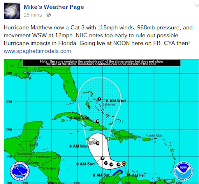
Cone NHC


NHC trying hard not to put FL into the cone.
Models trending West so that may be hard.
Right now you watch Matthew dance, spin and wait.
Data from recon is impressive.
And NHC has it strengthening down the road possibly.
Cat 5?


Could it hit 145 MPH?


Those dark reds, magenta and maroon is HOT.
IF it turns fast it misses the hottest water.
If not... really would be epic.


Models:


Some of the models are breaking West.
But it's a long ways away.

NRL MAP .. AKA NAVY CONCERNS


Florida is a concern. Obviously.
But before we worry on Florida...
Jamaica
Cuba.
Haiti.
Bahamas.
ALL IN IT!!!!

So let's worry on Florida and NC later.
Much later we can worry on the East Coast scenarios.


Okay there are some hurricane history facts.
NC always worries.
I'm sure there are people far to the West of Matthew worried.

Models show a turn.

Canadian Hurricane Centre shows a turn.
(yes they spell it that way...)


I show you these 3 maps to see they all agree on the turn.

Why?

wv-animated.gif (720×480)

See that swirling, dipping, gigantic low?
Watch to see if and when it digs.
I don't mean IF as much as when.. ...
See the flow pulling North on back side up the East Coast?
I have a Severe Thunderstorm Warning because of it.

Now look South towards Matthew, Category 4 Hurricane


In theory that double barreled Hurricane will lift towards the poles.
The Jamaican and Cuban coast are in the way of the poles.
That is why they so often get hit by hurricanes from the South.

Unfortunately so far Matthew like a few before have not followed models.
In the end ...yes... but so far ignored normal rules of science.
Intensified despite shear and near the South American coast.


Pretty much says it well.

Also watch wobbles in the eye for direction.
Wait for real movement as it will bobble around a bit.


Recon is out there.. data coming in nonstop.


Flying around in circles collecting data.

Mike from Spaghetti Models fame...
Says pretty much what I think and others say.


This is the real concern.
Easy to read NHC Discussion.
They basically explain why they missed the RI.
RI = Rapid Intensification.
And explain what we all know.. it may strengthen.


Ummm like a speeding bullet.
Or maybe a slow bullet.
Models disagree on forward speed.
Since day one this has been a problem.
Remember when days ago I said they were far apart.
Spoiler Alert.. the slow model beat out the fast one.


Wind Probabilities are going up along the East Coast.
Miami is up to 50% from the normal 34%
Everyone above is 34%


Higher Concerns.

I want to address an issue that relates to many of my friends in South Florida. Many are nervous when they see a hurricane of any kind, let alone a Cat 4 Hurricane, just before the Jewish High Holy Days. It's the New Year and with that many take off from work, go to Temple, go to Grandma's House ..which means traveling by Jetblue from NY to Boca... and some stay offline others do not. But, with the holidays coming up everyone keeps asking me "If Miami will be impacted?" "Will it be a problem flying into MIA or FLL" or rather flying out... it's a concern and many have asked do they shop for the storm or take a chance it stays out to sea. I'd say IF the trend towards the West continues and IF you are in the cone on Saturday Evening... go to the store. Go to Walmart or wherever and shop for hurricane supplies along with whatever you are cooking. And this also is for anyone who wants a heads up. It's possible Miami could get weather from Matthew even if it stays off shore 75 miles or so. If it stays off shore  150 miles you'll have some water and snack food. Use it for the kids or donate it to a shelter as whatever you are buying will be non-perishable. It's just too soon to say but go about life, pray, have a good day, check back Saturday Night and see if you are in the cone and if so .... you may as well go shopping as you buy produce for the High Holidays. That's my thought. We can discuss this more on Saturday Night and Sunday. 

It's a concern many have down in Miami as Hurricanes often hit or come near during the Jewish New Year. Old, old timers remember their grandparents talking on the Great Miami Hurricane that came on Yom Kippur.. aka Judgement Day on the biblical level and they must have felt their whole world was ending as storm surge swept over Miami Beach. So nothing surprising here but a lot of newcomers to the Miami area and many do not know.

For my friends with relatives in Haiti .. yes they may get torrential rains and I am praying for your relatives and friends as it doesn't take much rain for Haiti that has little ground cover anymore to get flash floods.  Leaving this link up for people who do not know what I am speaking on but it's a factor in the flash flooding problem. Then again back in 1963 when Flora made landfall I believe over 5,000 people died and there were trees and it still was a problem. It's always been a problem.

http://www.triplepundit.com/2015/01/deforestation-slows-recovery-haiti

Been a problem for a while.
So even a strong glancing  glow can be bad, very bad.


Cuba has some of the best meteorologists anywhere. But it is a poor country in many places outside the beautiful tourist areas and a strong hurricane could kill many and do terrible damage. And I have many friends in Miami who have a sad feeling in the pit of their stomach when they see a Major Hurricane track that takes it across Cuba. 

In reality we watch this storm carefully whether we are in Florida or North Carolina. Whether we have loved ones in Cuba or in Haiti as Miami is a diverse, beautiful city filled with some of the best people in the world and obviously the Caribbean. North Carolina we can talk on way later.

https://philfactor-phil.blogspot.com/

Phil Ferro from Channel 7 in Miami writes a great blog.
It's specifically for the local Miami market.


That IS your bottom line.

What do I think?

I think that a Category 4 Hurricane that hasn't followed the rules.
Most likely will continue to not follow the rules.

In theory it will feel the pull to go poleward.

The DIP is in play now.

sat_wv_east_loop-12.gif (640×512)

What will Matthew say to the trof.
A Major Hurricane establishes it's own High aloft.
That high can make it's own steering current.
The models say it goes North.
It could miss South Florida and cross Cuba by Gitmo.
It could do something else... 

Time will tell.
Stay tuned.

Follow along on www.spaghettimodels.com
www.hurricanecity.com
www.canetalk.com
www.crownweather.com
www.flhurricane.com
http://www.stormcarib.com/ (read comments on right)
http://www.nhc.noaa.gov/
https://twitter.com/hurrtrackerapp (download their app)

And really watch Matthew.
Don't obsess on models as much as what Matthew does.

wv-animated.gif (1120×480)

There is your drama in real time so take a break from the model drama.
Learn from the NHC ..do not underestimate this hurricane.
I'm being honest here... 

Oh there is a wave coming off of Africa..
People have asked...

http://www.intellicast.com/Storm/Hurricane/AtlanticSatellite.aspx

...and moisture behind Matthew in Central Atlantic.
Though usually when you have a Major Cane a lot of energy is taken up.
But this Cane doesn't follow rules so keep watching.


As always the NHC is the bottom line.
Will go long on thoughts Saturday evening.
Many models before here and there.
And where will Matthew be and how strong?
And what will the cone look like?

http://www.nhc.noaa.gov/

Besos BobbiStorm
@bobbistorm on Twitter

Ps don't forget to read Discussion on NHC


UPDATED!! 120 MPH STRONGER..Will It Be 125 MPH at 5? Major Hurricane Matthew .. Where Will He Go After Carib? Intensifying .. Eye Popping Out. NHC CANNOT RULE OUT S FL IMPACTS. Cuba Major Cane. Jamaica Prepare

2 PM STRONGER
120 MPH
Intensifying.
Despite land near by and moderate shear.

WSW 12 MPH (slow helps intensification)
960 MB (recon reports deepening)
Sustained 120 MPH

As I said earlier I felt the intensity forecast was too conservative.
There was discussion it could be brief short term..
.. maybe eye was clouding over.
They like their forecasts to verify.
Usually they do but when you have a storm that breaks the rules.
They break the rules big time.

From my knowledge of tropical meteorology.
And I have a lot of knowledge and experience.
That's more like 125 MPH...

jsl_lalo-animated.gif (720×480)

See the purples in the red.
Happens rarely.

Perfect evacuation of energy with this storm.
Despite the odd caboose it's carrying with it.
Another storm did this can't remember which now.
Will find it later.


With a dangerous system like this...
A dangerous Major Hurricane.
Many things can happen.
They have a tendency to break the rules.
To make their own rules...within the realm of science.
Later we re-evaluate it and understand what happened better.
The NHC does a great job at the end of the season doing that.
Then it is studied and knowledge learned for the future.


Keep reading. 
New package out at 5 PM.
Cone should stay the same give or take.
The big question is if this stalls or slows down.
If so could intensify fast, then have upwelling.
But that is just one possibility. 

Jamaica could have a big problem.
Again Haiti even far away will get intense rainfall in squalls.


Keep watching... keep reading.


ft-animated.gif (720×480)

Eye popping out.
Doing that two partner tango dance again.
Last time it did that it strengthened go figure.

16 nautical mile wide eye observed by Recon
Outflow bands.
Good symmetry in all directions.
Major Cane


Look at that picture.
Note how precisely rounded off it is on SW side.
South side... outflow channel NE
Beginning to form more than 1 outflow channel.
That's how major hurricanes work.
They pump, in, out and breathe like a heavyweight fighter
This occurred CLOSE IN to the South American coast.
This rapid intensification occurred despite some shear.
Over very warm hot water.
And the water gets HOTTER when it pulls North into Carib.
HWRF model I posted the other day has been on target.
All the talk on EURO vs GFS and HWRF scores high!
Remember the discussion of possible Cat 4 in Carib?
The dip to the SW followed by ballistic path to the N?
Problem is models that do the track well miss intensity.
And the NHC has to average them all out carefully.
Too often NHC plays it conservative.
Often that works well.
When you get a Mitch like Matthew you got to be careful.

EURO shows a very strong hurricane.
A sharper turn out to sea.
Cuba and then misses FL easily.
Sorry Bahamas...
Busts thru Turks and Caicos ..
924 MB
Follows a small low out to sea.
As if it's directing it away


http://moe.met.fsu.edu/cgi-bin/gfstc2.cgi?time=2016093006&field=Sea+Level+Pressure&hour=Animation

If you run this loop you will see.
It cross Cuba as a very strong Hurricane.
It's one sort of run...


Moves slower than the EURO
And parks off the coast of NC has a monster.


GFS keeps it closer to the coast.
There are MANY models.
www.hurricanecity.com is a good source for models.
Jim Williams is good at pointing out which models are best.
Often models you have never heard of so check it out

You can't really rule them all out.
And some do break West and come dangerously close to
Florida

Let's take the GFDL


126 Hours out...

Crosses Jamaica with a landfall


Then slides up JULIA style near the Cape..
Cape Kennedy not OBX


Based on the patterns THIS year that cannot be ruled out.
It's easy to say it most likely will go out to sea and miss FL.
But it can't be ruled out that it doesn't or affects it in some way.

So we have different scenarios.

1. Cat 2 would feel the pull and pull North.
Strong dip in the atmosphere present
Picks it up and hurls it out to sea..


2. Cat 3 intensifying into a Cat 4 ignores it for now.
Cat 3 slows at edge of High and becomes Cat 4

latest_wv_loop.gif (535×440)

Watch the blue High... see where it stops pushing West.
That's where Matthew should* slow down.
When a Cat 3 slows down over hot water.
It intensifies.. maybe a Cat 4 even.

3. Cat 3 or 4 makes it's own weather.
How? The outflow builds a high aloft.
Happens rarely but does happen.
Sometimes they continue forward motion longer ..West.
They feel the pull eventually and turn slower than a strong Cat 2.
Timing is very important here.
Intensity forecasting is very important here.
NHC at 11 AM says this about that.


a) Can't rule out impacts to South Florida
b) They keep it at 115 MPH.

Bobbistorm's Bottom Line on that..
I think they are erring on the side of too conservative.

I think this will intensify.
As it pulls more to the N of WSW at 12 MPH..
..and the eye opening up.
It will intensify some.
It's simple Tropical Meteorology 101.

Until South Florida is off this grid .. I'd be careful.


Yes close to South America but so far hasn't hurt it.
Or perhaps it has kept it from being stronger.

I'll talk on Jamaica later today.
Cuba later today.
Saturday Night is the big time to think on Florida.

Matthew below looking as good as it gets.


This part of the world in October is bad for Jamaica.


That's Mitch a late October storm.
No big dip to grab it and then and it did dip to SW WSW
But we do have what to pull Matthew North .. in theory

http://www.nhc.noaa.gov/text/refresh/MIAPWSAT4+shtml/301447.shtml?

Wind probabilities for Matthew up to Elizabeth City, NC
Some more to the West. Check them out.

I'll update in real time later this afternoon.


Mike says it well.
So does my friend Alfred Spellman.


Yes Alfred all of South Florida should watch this storm carefully.

Besos BobbiStorm
@bobbistorm on Twitter


I like loops that show you the process

sat_ir_enh_east_loop-12.gif (640×512)


Major Hurricane Matthew .. Where Will He Go After Carib? Intensifying .. Eye Popping Out. NHC CANNOT RULE OUT S FL IMPACTS. Cuba Major Cane. Jamaica Prepare

2 PM STRONGER
120 MPH
Intensifying.
Despite land near by and moderate shear.

WSW 12 MPH (slow helps intensification)
960 MB (recon reports deepening)
Sustained 120 MPH

As I said earlier I felt the intensity forecast was too conservative.
There was discussion it could be brief short term..
.. maybe eye was clouding over.
They like their forecasts to verify.
Usually they do but when you have a storm that breaks the rules.
They break the rules big time.


ft-animated.gif (720×480)

Eye popping out.
Doing that two partner tango dance again.
Last time it did that it strengthened go figure.

16 nautical mile wide eye observed by Recon
Outflow bands.
Good symmetry in all directions.
Major Cane


Look at that picture.
Note how precisely rounded off it is on SW side.
South side... outflow channel NE
Beginning to form more than 1 outflow channel.
That's how major hurricanes work.
They pump, in, out and breathe like a heavyweight fighter
This occurred CLOSE IN to the South American coast.
This rapid intensification occurred despite some shear.
Over very warm hot water.
And the water gets HOTTER when it pulls North into Carib.
HWRF model I posted the other day has been on target.
All the talk on EURO vs GFS and HWRF scores high!
Remember the discussion of possible Cat 4 in Carib?
The dip to the SW followed by ballistic path to the N?
Problem is models that do the track well miss intensity.
And the NHC has to average them all out carefully.
Too often NHC plays it conservative.
Often that works well.
When you get a Mitch like Matthew you got to be careful.

EURO shows a very strong hurricane.
A sharper turn out to sea.
Cuba and then misses FL easily.
Sorry Bahamas...
Busts thru Turks and Caicos ..
924 MB
Follows a small low out to sea.
As if it's directing it away


http://moe.met.fsu.edu/cgi-bin/gfstc2.cgi?time=2016093006&field=Sea+Level+Pressure&hour=Animation

If you run this loop you will see.
It cross Cuba as a very strong Hurricane.
It's one sort of run...


Moves slower than the EURO
And parks off the coast of NC has a monster.


GFS keeps it closer to the coast.
There are MANY models.
www.hurricanecity.com is a good source for models.
Jim Williams is good at pointing out which models are best.
Often models you have never heard of so check it out

You can't really rule them all out.
And some do break West and come dangerously close to
Florida

Let's take the GFDL


126 Hours out...

Crosses Jamaica with a landfall


Then slides up JULIA style near the Cape..
Cape Kennedy not OBX


Based on the patterns THIS year that cannot be ruled out.
It's easy to say it most likely will go out to sea and miss FL.
But it can't be ruled out that it doesn't or affects it in some way.

So we have different scenarios.

1. Cat 2 would feel the pull and pull North.
Strong dip in the atmosphere present
Picks it up and hurls it out to sea..


2. Cat 3 intensifying into a Cat 4 ignores it for now.
Cat 3 slows at edge of High and becomes Cat 4

latest_wv_loop.gif (535×440)

Watch the blue High... see where it stops pushing West.
That's where Matthew should* slow down.
When a Cat 3 slows down over hot water.
It intensifies.. maybe a Cat 4 even.

3. Cat 3 or 4 makes it's own weather.
How? The outflow builds a high aloft.
Happens rarely but does happen.
Sometimes they continue forward motion longer ..West.
They feel the pull eventually and turn slower than a strong Cat 2.
Timing is very important here.
Intensity forecasting is very important here.
NHC at 11 AM says this about that.


a) Can't rule out impacts to South Florida
b) They keep it at 115 MPH.

Bobbistorm's Bottom Line on that..
I think they are erring on the side of too conservative.

I think this will intensify.
As it pulls more to the N of WSW at 12 MPH..
..and the eye opening up.
It will intensify some.
It's simple Tropical Meteorology 101.

Until South Florida is off this grid .. I'd be careful.


Yes close to South America but so far hasn't hurt it.
Or perhaps it has kept it from being stronger.

I'll talk on Jamaica later today.
Cuba later today.
Saturday Night is the big time to think on Florida.

Matthew below looking as good as it gets.


This part of the world in October is bad for Jamaica.


That's Mitch a late October storm.
No big dip to grab it and then and it did dip to SW WSW
But we do have what to pull Matthew North .. in theory

http://www.nhc.noaa.gov/text/refresh/MIAPWSAT4+shtml/301447.shtml?

Wind probabilities for Matthew up to Elizabeth City, NC
Some more to the West. Check them out.

I'll update in real time later this afternoon.


Mike says it well.
So does my friend Alfred Spellman.


Yes Alfred all of South Florida should watch this storm carefully.

Besos BobbiStorm
@bobbistorm on Twitter


I like loops that show you the process

sat_ir_enh_east_loop-12.gif (640×512)