Hurricane Harbor

A writer and a tropical muse. A funky Lubavitcher who enjoys watching the weather, hurricanes, listening to music while enjoying life with a sense of humor and trying to make sense of it all!

Monday, July 31, 2023

Last Day of July. Tropics Fairly Quiet. 2 Invests and a Quiet GOM & ATL. What Will August Bring?.


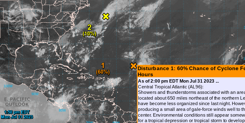
This is where we are at 2 PM.
Monday, July 31st, 2023.

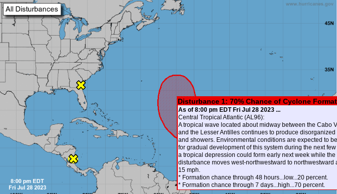
I waited to write the blog to see what the NHC would do at 2 PM. They are keeping 96L at red circle, yet it's chances are currently 70% on the 7 day. Our fast moving invest 97L "lil yellow circle" is moving fast like it's trying to escape Earth's atmosphere and trying to go find the missing Voyager space craft that is no longer receiving commands from NASA. I am of couse being silly, but they are hoping to reset it Voyager in October and well often the hurricane models don't seem to be connecting with reality weather wise also.  


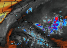
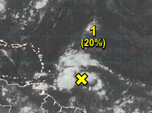
Note the vigorous lil wave.


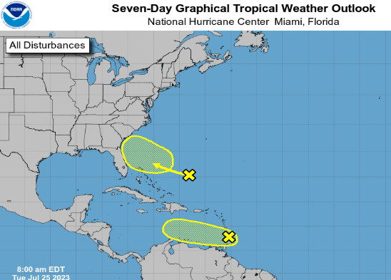
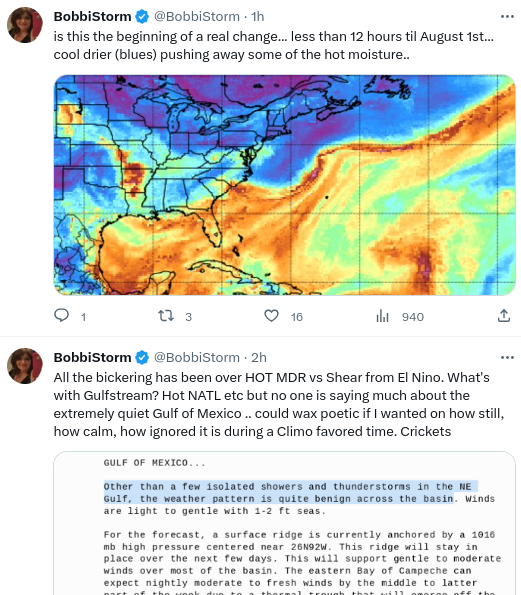
Let's look at the satellite imagery on the 2 day forecast page from the NHC. Note the orange X is where Invest 96L is not where the 1 60% is to it's left. I say that as that graphic is actually near a nice little tropical wave getting little attention, yet it's blasting through the shear that's usually there this time of year as it moves westbound into the Caribbean. Most of the US is devoid of major convection though there are some areas that will flare up as they do in the summer and zip along slamming someone with severe weather. Isn't the Gulf of Mexico quiet for July, a time when usually it's climatologically favorable for development and add in we know how hot the water is currently. Then again the area off of Florida where the hot water temperatures have been in the media every day did not produce a tropical system when the little yellow circle showed up with a high aloft and low shear there. Quite the puzzle but other than not having enough time over the water, under high pressure with low shear it wasn't able yet to get a center going even though there was some spin.

This is really a look back at July.
Quiet Gulf of Mexico and adjacent Bay of Campeche.
Quiet Caribbean other than the old wave rebounding and heading into the Pacific.
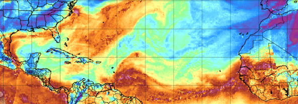
The MDR has been very quiet, as it usually is in July, as tropical waves tried to fight off the SAL.
The North Atlantic has been a friendlier spot for development as we saw with Don and Invests 95L and 96L
African Waves, there were a few good ones, came off beautiful and fell apart due to SAL. Happens in July.

You could say "well we are already looking for the E storm in late July... oh my!!"
Yes, you can say that but in reality it needs an asterisk as it's only because of the upgraded January storm.
Otherwise..........we would be looking for the D storm and not looking for the E storm.
Not being contrary, just being honest and transparent because it's true.

So where do we go from here.


Some changes going on.
A front pushed through.
Another small front pushed down.
Died around SC I heard.
Most early fronts do die there.
Then we watch the end of dead fronts.
That just hang around... off SE Coast.
(over very warm water)

BUT...........nothing is forecast to develop.
Models are tight lipped and saying no, no, no!

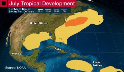
In truth July is usually slow. There's always exceptions to the rule but Hurricane Bertha was a real exception to the rule. And, when we have development (unless it's in the GOM) it's often short lived weak storms that attain a name but no real fame. So let's look at where we normally find August development in the Atlantic Tropical Basin.


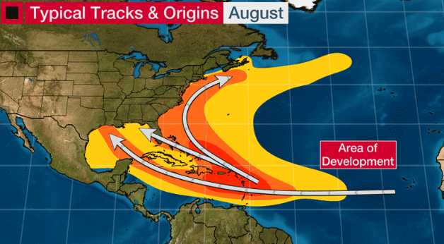
Pretty much anywhere.
Make from Wundground I believe.
Orange is closer in...
..note the sneaky track into the GOM.
Many recurve up along the coastline.
Some make landfall.


Intresting graphic.
Despite hot water everywhere close in...
...it's most intensely hot water.
BOC is hot but quiet.
(yes shear from El Nino)

And then there's Upper Level Lows.
They can enhance development.
Or they can inhibit it with shear.


Upper Level Lows get a vote too!
See the 2 black looking dark Cane like features.
Lows... Upper Level Lows.
They have been dogging 96L
If one was to the SW of 96L...
..would help ventilate it some.
When they are on top of it...
..they make it difficult to get going.

Kind of like life right?
If it's not one thing it's another.
You roll with the punches.
You make lemonade out of lemons.
Pink lemonade if you're Barbie?

But seriously...

Hang in there.

I will say I'll be very surprised, but not shocked, if we do not reach the high expectations numbers wise that have been forecast for the 2023 Hurricane Season. We could have weak storms named, and as fronts become stronger they will mostly be swept out to sea. But, then there is that exception to the rule that makes a perfect set up for a dreaded, dangerous landfall. Every season produces something eventually, last year was slow despite all the "Go for Lift Off!" articles and yet we all remember Hurricane Ian. 


Stay prepared.
Stay aware.
Know August usually ups the ante.
If by say August 18th it's still slow.
We're gonna have to rethink the very busy season.
Especially if winter forecasts verify.
There's a door for strong development.
It's opening.
At some point it snaps shut.
Time will tell.
Stay tuned.

Have a good day.
Happy August...
..maybe it be just what you want.
I know what many of you want........
...and many of you do not want!

BobbiStorm
@bobbistorm on Twitter and Instagram
Twitter mostly weather..
..Instagram whatever.
Yeah Threads too.

First song that comes to mind...
... have a fun rest of Summer.


Sunday, July 30, 2023

3 Areas Being Monitored. 96L (seems like forever) 97L Off Carolina Coast and 96E in EPAC (because you know who) Why is Atlantic So Unfriendly? For Normal Reasons in July & Early August. StayTuned... Remember September. Normal Season Afterall Despite Headlines on Hot Water


(from Zoom Earth)

96L in ATL for what seems like days.
Coming out of the SAL...
..as if finds the NATL

NHC 8 AM Sunday 

97L now off Carolina Coast.
Trough moving through
...headed up into the NATL like 96L
Do they meet for coffee somewhere?

96E in the EPAC....
DNA from tropical wave in ATL


Gonna keep this blog short today. It's Sunday and it's a day to play and it's slipping away and I want to do something. The honest truth is the Atlantic, the Tropical part of the Atlantic, is not a very friendly place right now for tropical development. The stronger waves have been good seeds for weather in the Islands, and the tropical wave that looked like a Tropical Depression but did not get designation kept going West and is now part of the red circle in the EPAC that laid out a Red Carpet for the long tracking tropical wave. The EPAC has been fairly quiet too, especially with high hopes for activity due to the nearby El Nino. 

The Atlantic that opened to rave reviews on how hot  red, hot Atlantic Ocean was with temperatures so high it stole attention away from the slowly building El Nino has been but the Atlantic hot ocean was not a very friendly place despite HOT WATER.  Off the SE coast we had an area of consistent troubled weather hovering (almost anchored) over some of the hottest water in the basin with a high a loft and nothing happened. Nothing happened and yes there is a reason for that too and it has to do with the atmosphere, air pushing down over the yellow circle with the "best conditions" (according to Click Bait) for development suppressing development. 

The reason I mention this is because all the Click Bait you read about how hot the Atlantic is promising you an early, busy hurricane season failed to mention the all the various dynamics, synoptics of weather and tropical development and like a late night commercial on The Weather Channel promising you something that will save your kitchen sink, toilet or make your house smell beautiful while some on air barker who grew up in the carnival business yells at you to BUY BUY BUY and many will and many won't and the click bait chorus online of HOT WATER has not yet amounted to much.

You need a center. You need a core. You need less shear, less SAL and some lift out there in atmosphere that takes those building clouds and spins them around, lifts them up that helps them spread out and if you don't have that nothing spins all you got is Hot Water. And yes we have seen this over time, even last year that opened to rave reviews of HOT WATER was a kind of mediocre early hurricane season until a few sparked in the Caribbean (no El Nino then) and people mostly remember Ian after Earl and Fiona flared up with some color but few remember the two little tropical systems that developed early and then we waited and waited.


It was a long August.
But as we remember September.
Trouble happens in September.


Just Google you'll see it's true!

So not such a short blog but this is what I wanted to say. Normal season despite the drama and headlines on how hot the water is in the Atlantic and OMG off the Florida coast (yet the AOI didn't develop) so remember September and late August (probably after or around the 18th give or take) because Mother Nature takes her own time, year after year, time after time. 

Stay tuned. Don't eat the hurricane supplies and keep them hidden away and locked up.

 Hurricane History.
2009 Hurricane Season.
Gonna show a few of these this week.
A look back at few relevant years.
Not the same, just some similarities.

That's it.
I'm taking a shower and going out.
What to wear? What to wear?
Time will tell....

Besos BobbiStorm
@bobbistorm on Twitter and Instgram
Twitter mostly weather Instagram whatever
Yeah Threads too...


God I love this song.
Truth a Tango Dancer who left Cuba...
..taught me to tango when I was little.
Cha Cha... Rumba.
And don't even get me started on Can Can

;)


Friday, July 28, 2023

Invest 96L Tagged From MDR Wave at 70% in the 7 Day Period. 2 Areas Close to Land Not Expected to Develop. New Wave Off Africa Looks Impressive.


Models like thie wave in the MDR
Expected to recurve in the Atlantic.
According to models....
X AOI Near Florida made landfall...
...now by the FL/GA line.


Nice little circulation.
Not classified.
Dumped lots of rain on Florida
Dumping more on coastal SE.


Northern area the FL AOI
Southern is 95L going into EPAC
EPAC has a Red Circle waiting for it.

I could go long on how the EPAC has been quiet but I won't, lets see what happens when X95L gets there. A new wave emerged off the African coast, if this develops and I like it as it's more consolidated than Invest 96L is and has a look to me. Small model support, let's let it swim a bit and see what happens.

I've been offline much the last two days, the weather is horribly hot it stirs up my allergies and asthma, I'm fine just needed a rest.

I'll be on Satuday evening with a new blog discussing the new African Waves, El Nino (getting stronger every day) and if the MDR wave is really going to form and will it stay a fish storm. It's a large wave complex and I'm not in love with it. But, models support it more or less and NHC raised the ante to the red circle now.

Stay cool, stay hydrated. Tropics quiet but the weather is still deadly when it's this hot and there is a front moving across the SE. Once fronts begin moving the tropics tend to heat up as well. 

Stay tuned... 
Besos BobbiStorm
@bobbistorm on Twitter and Instagram

As the tropics have been quiet, here's something tropical to entertain you...


Wednesday, July 26, 2023

SFL Getting Rains from X AOI in Bahamas.........African Wave Last Yellow Circle Standing........... Where Does Remnants of X 95L Go?


Note the shaded circle is where it could form.
The X is where it is now.
Keep that in mind.

I say that because models do not really develop it until later, closer in as it has an unfriendly environment to move through to get "there" where the shaded yellow grid is and until that it will be tested by strong Saharan Dust aka SAL and less than spectacular conditions. We really aren't there yet... but when that switch gets flipped to "ON" the Tropics will come to life in one way or another.


From Zoom Earth.
Dotted white dots is SAL.
SAL dries out the air.
Air is the environment.
So this wave is being monitored.


Closer in is our old X AOI.
Now commonly known as
OMG WHATS WITH THE RAIN


Kids sending me pics.
The Rains return.
Heat will come down some.

In Miami what keeps the heat normally down is afternoon rain showers when it gets that hot to be record breaking, yet the rains came early and left just as fast this "rainy season" and now with their return things will cool off so it's either complain about the heat or the heavy rain. It's Miami. Born and raised there, that's the way of the world. Some years, like 1992, are hotter, drier and other years it pours from May through the Summer. Don't complain about the rain!


It'll bring the temperatures down.
Let's compare Raleigh and Miami 


These ae actual temperatures not feels like.
Saturday forecast to be 99 degrees in Raleigh.
We'll see.
Feels like I don't want to know.
Gonna play in the bathtub....
...sip cold dinks.


Shifting over to Google to show you...
...how it's that easy.
To stay on top of the weather.
Shift it to Precipitation.
Voila! 
The old AOI has juice in it!
And it's juicing up Miami !

So does the ITCZ


See the lil purples in there?
I so love purple.
That's energy, juicy energy.
New wave is high and that's good.
Good because it's fighting the SAL some.
Good for those August waves.
And maybe... just maybe.
It'll pull together.

Time will tell.

Sorry for sounding silly today, I'm silly and tired and I didn't sleep more than 4 hours which used to work for me when I liked to Party in the USA lol but need more sleep or a long shower. If you know me the shower is gonna win out.

I'll update later when there's something real to say. It's a day... of waiting, watching. You can chase the models or you can wait for CLIMO to kick in and then the tropics are lit. Your choice. My choice is a shower and then some more better coffee. That's an old Southern saying... at some point we will get more better waves and slowly, wave by wave the Saharan Dust will not rule the Atlatnic!


Africa today.
Maybe we need more better rain over Africa??

Bottom line is top of Mike's page.


Rains in FL today from X Yellow Circle.
New Yellow Circle down the road.
Some juice left in X 95L
(where does that go?)

Have a good day!

BobbiStorm
@bobbistorm on Twitter and Instagram
Twitter mostly weather.
Instagram weather and whatever.
Threads when I go there... 
...if you are there let me know.


Tuesday, July 25, 2023

AOI off SE Coast Interesting. 95L an Open Wave. Not Talking Yet on African Wave..


This is the first image in a loop.
95L getting so much attention.
Why? 
And few talking on how energy shifted in 95L
Northern edge of 95L has more convection.
Despite models focusing on the lower track.


95L is IN the Islands.


Study this image you will see a lot.
What's pulling it.
Convection sheared, normal there in July.
Strong bending convection to the N
tho lead convection went S
It's been a mess last few days.
Yet we still talking on it.
Sometimes they come back to life...
...so we watch.

Not expected to...


I'm more curious on things closer in.
Closer to land, the coast, cities in SE US.

As Levi Cowan says here.
95L is an open wave.


That means it's dead in the water.
Just rain on your wedding day.
Just convection.
Let's move on...
..circle back if something changes.
Let it go...

NHC this morning...
...oh what's that.
So clsoe to the coast?
Let's focus on that!


NHC giving 95L next to zero chances.
Close to the coast there's a circle and a X.
X for Twitter huh?
Teasing.
Shaded area is where it could develop.

Go back to the top.
Yesteday no real convection there.
This morning there's convection.


So let me explain.


Bottom left there's a curved red line.
South to N this is an ULL 
Upper Level Low


That ULL helped to shear tear apart 95L
They can do that... add shear somewhere.
Shear wannabe tropical systems.
It's all about locaiton.
Being there is bad for 95L
"bad" for development.
Not bad for those worried on development.


Low here to the SW of an AOI is different.
Area of Interest.
The Yellow Circle off the SE
Depending on many things.
That could help ventilate it a bit.
Not inhibit it but help it.
All very iffy.
Why?

Because ULLs move around.
They fade and then come back.
They are incredible to watch in July.


Going wide again....
There's a front... kind of dead front.
Does it really feel cool anywhere there?
Oh it was 69 for a NY minute at 6 AM in NC
By 9 AM it was 85 here.
Fading decaying fronts help development.
Shape of the coast and heat of the Gulfstream.
Often have helped a fast spin up there in July.

There's a reason the NHC put it there and the fact that models aren't huge on it doesn't phase me as models were hot to trot on 95L and the wave before that one too. The water there is hot as every weather person in America will tell you right now and add in the heat and the lay of the Gulfstream and IF anything develops there it could impact our weather along the SE coast from S FL to Carolinas and beyond.

Yeah it's an IF but it's all been an IF because it's July. When I was young and first doing this I'd get excited about any signs of rain/convection aka color on a satellite image and think "it could develop, it could develop" and some older, wiser, boring, annoying met would say to me "Bobbi it's July" and I'd think "it's gonna develop, it could develop...." and they'd bring out their heavy wand of CLIMO in capital letters and I'd think "it could develop" and yeah ...no.......it didn't develop. Okay, Bertha developed, there's always that one or two but in July it takes moe than hot water beneath the convection to get a tropical wave spinning especially when it's swimming in a sea of SAL.


Orange/red/gold SAL 
Saharn Dust enemy of tropical waves.
95L is surrounded by SAL.
Coastal Blob being watched....
...is not.
Today it's a blob.
Yesterday it wasn't not.
What will it be tomorrow?


I tweeted this yesteday.
Bottom center black and white sat image.


Took me a minute.
That's Katrina.
Off the SE Coast... before it developed.
I'm NOT saying this is Katrina
or anything like it.
But it developed from a similar set up.
Different but similar.

Years back I did a lot of research at the NHC in the library going through old papers, books, studies and good friends with a few people there. I learned a lot, more than I would in any of the meteorology classes I took in college for my degree in GeoPolitics trust me. My neighbors growing up in Miami were meteorologists who flew into hurricanes and worked at the NHC. One in particular would explain to me as a child what the pictures that lined the wall of his mother's house next door showed other than just a lot of cloud banks. Not all storms form from Tropical Waves. Sometimes an Upper Level Low gets too big for it's britches, gulps in moisture and it gets entrained in it and develops into a tropical storm. Sometimes a mid level trough off of SFL in conjunction with other moisture from a nearby weak tropical wave and general atmospheric conditions spins up into a Hurricane as Katrina did tho Katrina was the exception most slide up along the Gulfstream like a child with a box of candy not leaving until he' got all the sugar he could get ... Gulfstream can be like steroids and a blob can pull together fast especially between N FL and Georgia in the Georiga Bight an area that's somewhat shelted.

So with all this talk you want to know where it can go?

It can stay there undeveloped and rain which would be good for Florida as the high, record temperatures would come down. It could up the ante for showers along the Florida coast even crossing Florida just a little bit and making rain fall everywhere. Rain is good unless it's floods because it brings down the crazy temperatures. One reason for the high record temperatures every day in Florida is there have been barely any afternoon thunderstorms except for isolated cells popping up over my son's concert he went to yesterday in WPB. Daily monsoons help keep the temperatures down and they have been few and far between or you'd see them on the news with associated stories of how South Florida is flooding. 

If it develops and pulls up the coast it's anyone's guess because it's currently not an Invest, the models barely see it and the wise forecasters at the NHC have it there as a yellow X (really a question mark) to remind people in the area something might develop and they are watching it. And, that is good.

I'm not going long on the new African Wave yet as ..........it's not the best wave and the models that like it liked the last two and neither developed. Another few weeks they may be more productive but hey we watch it anyway because that's what we do


This is a lack luster African Wave Train
Even for July.
SAL is the white dots in the blue ocean.

Not Yet.

Gotta run..
..got a chiropractor appointment!

I'll proof this and update later.
Sweet tropical dreams.
Stay in the shade.

BobbiStorm
@bobbistorm on Twitter and Intagram
Threads also look me up there.
Say hi.


Monday, July 24, 2023

Yellow Circle Off SE Coast 20% - Don Devalued... 95L Bringing Tropical Rains to the Islands. What's Behind 95L? That'll Have to Wait for Now..


This is from a trough of low pressure.
Climo wise in July this is a spot we watch.
MDR is usually on hold.
Due to SAL and shear
Near the coastline things can spin up.


So this is our area of convection.
A lot going on there.
Just watching it.
You have to think where would it go...
...if it tried to develop?


See the small red line N of PR?
East of Florida.

That is what we are watching.
Old frontal boundary near NC
High in place...
..so where would it go?

I'll update later today.
Just wanted to put this here on blog.

95L has gained in girth...
..and headed to the islands.
Will bring flooding rains to some places..
..that have terrain.

terrain + rain = flooding.

While 95L lacks a circulation.
It's got a lot of rain today.
And it's moving towards the Islands.


So remember that.
Oh and behind it is another wave.
For now the NHC went with the close in area.
Actually I totally agree...
...wait and see


There's your moisture "ring of fire" 
It oozes, it moves.
It slides around.
95L bright ..
ITCZ behind it...
new wave behind it.
Area of moisture to NW of it.
El Nino like stream of air ...
up and thru ...across GOM
Feeds into dangling cold front...
..that's now just limp in the water.
Warm Water.
Gulfstream.


New area of interest.
20% in the next 7 days.
Area we normally watch in July

Time will tell

BobbiStorm
@bobbistorm on Twitter and Instagram
Threads.......


Don is Off to See the Wizard and 95L Doing Strange Things... Got Bigger, 2 Vorts There. Models Disagree. What Else Is New?


95L found convection but ....
...lost it's sense of spin.


Now it's just a kink in the isobars.
NHC down to 20% yellow.


As for models.
EURO crashes it into Central America.


The GFS, God bless it's dramatic heart.
Is putting out fantasy Canes again.


Cliff notes here on the GFS Fantasy Cane .... it forms into a wicked storm, hurricane moves towards South Florida and then does that popular pull out and slides along the coast. Cruises up with the Gulfstream and hits anything that sticks out far enough like OBX and then keeps on going up the coast to check out a Yankee RedSox game before zooming off into the NATL as Don gave it good reviews on Yelp. 


95L tries to stay alive by sucking moisture from..
...the wave behind it.
We saw this earlier in the season.
Bret did this with Cindy.
95L was tiny, now it's larger.
But.... it's got slim chances.

The white polka dots is SAL.
Saharan DUST.
Dry Air.

There is also shear!!


Do our eyes deceive us?

Truth is this is a very hostile time of year for tropical development in this region, because if it moves into the Eastern Caribbean there is no welcome mat out and shear shoots at it knocking away it's convection. Sometimes, once in a while an undeveloped wave has more than one vorticity signal and one move West into the Carib (despite all the red flags flying at the beach) and the other vort lifts a bit and tries to go up over the Islands IF there is some Low there that it wants to see because basically Lows go to Lows and stay away from Highs. Yet, the HIGH is there... even if the the GFS doesn't see it in a few days and well it's July.


Maybe, just maybe.
Euro stays with one vort
GFS takes the other one.

????


July sucks.
I'm sorry, great month for birthdays. Both my brothers are born in July. One of my all time favorite friends is born in July. July slides into August but unless you like hot weather....well it's not my personal favorite month. I have issues with August, always have and guess I always will as it's the time of year things change. But, August also has to be gotten through to get to September and I love September. September has hurricanes, football, cooler nights and the promise of a full blown Fall and Winter coming. Winter with the holidays and a decorated world ready for a party and the constant tease of snow that often arrives with time if you wait long enough. You can see the bones of the trees, their lines, the sky turns coral/lavender at sunset and the air is clear, crisp and boots are fun to wear! 

2023 has been an odd strange year zooming by, so as much as I complain about July and meteorologists endlessly say how hot it is.............it will subside, as will the Saharan Dust.

Everything changes. Remember that.

Remember September. When the GFS shows a Fantasy Cane in late August and September, even then you have to sit up and take a look at it before going quick to the EURO to see if it jives.  

And, as always the water vapor loop tells the tale better than most models in July.


There's the cyclone of 2023 so far.
But... at some point, it'll be dislodged.

One way or another it'll be dislodged.


Librarians zoom in...then go wide.
That's how research is done.

Look at that pretty low off of British Columbia.

Things spin all over the world.
Where we focus is what we see.
Change your focus, see other things.

It's Winter Down Under :)


 Thanks for your patience.
I'm in a mood.
Obviously.

Besos BobbiStorm
@bobbistorm on Twitter and Instagram
Threads also.... look me up there.

Son for Mike!