A writer and a tropical muse. A funky Lubavitcher who enjoys watching the weather, hurricanes, listening to music while enjoying life with a sense of humor and trying to make sense of it all!
Monday, October 30, 2023
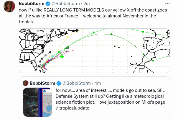
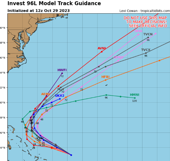
Orange in the Carib ... Expected to Try and Make a Run for the Red Roses in SW Carib. A Definite Maybe. AOI By Bahamas Expected to Turn NE soon.. Stay Tuned
Woke up with some allergy problems.
So going to keep this short....
....lest I write a novel ;)
Showing you the bottom line.
What could happen in the Carib?
This is really one big troughy mess N/S
NHC be weird this week.
Sure looks farely developed.
But they know the ending...
Down in Caribbean hmmm Nothing really matches up properly.
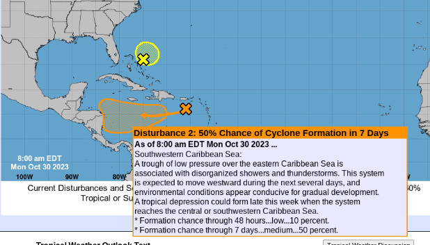
Area near the Bahamas down to 20%
small itsy bitsy yellow circle
despite looking quite nice on Earthnull.
Looks better on Earthnull but chances lowered.
New plot twist for Caribbean Possibilities.
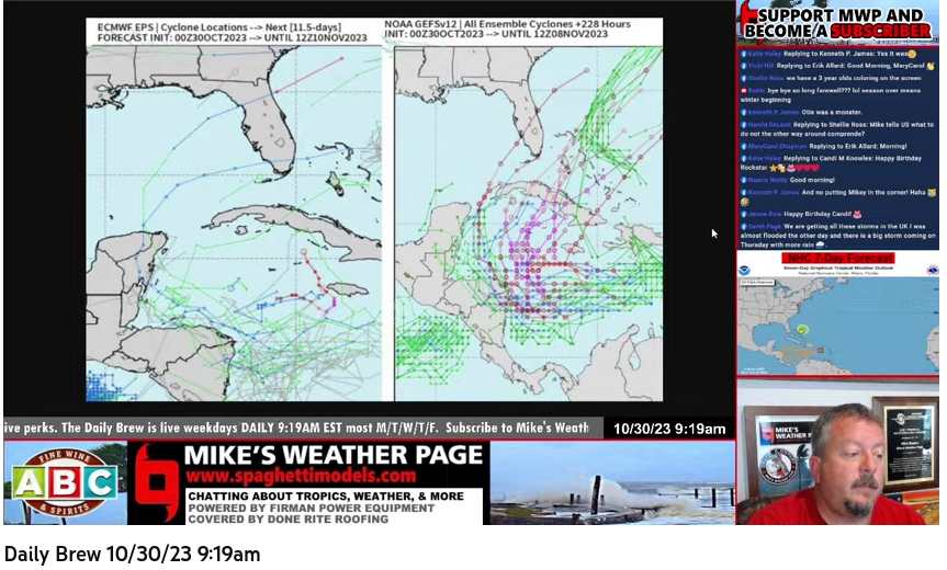
50% chances that something forms in the SW Carib from the X that's in the East Carib currently moving obviously West and may or may or not try to make a run for a November Caribbean Storm. Models change often so far and as the image above from Mike's Morning Brew as he says "Mother Nature's Hail Mary" from SW Caribbean later next week.
For now nothing is expected in the short term.
A cold front IS expected however.
I'm going to stop here. My heart really isn't into the tropics today and there's not much to grab a hold of... IF models change then maybe. If I thought there'd be a hurricane or tropical storm even I'd probably go "visit my kids" in Miami and see my best friend and hang out at Design District or walk along the Miami River meeting my brother for coffee somewhere. Trying to plan a trip later in the month, but who knows. After the surprise Acapulco Hurricane I'm a bit hestitant to laugh anything off ....
2023 is another interesting 2020 decade year. These are not the 20s I had hoped for....
Going to take a walk or go stimulate the economy a bit later today if I can't shake it off. I never was good at meditation.
Fall is beautiful here, sunny blue skies and fall color everywhere so will see if our orange area in the Carib turns red like the maple tree's leaves today.
Much Love
BobbiStorm
@bobbistorm on Twitter and Instagram
Ps not proofing this so if my spelling is off... oops, sorry!!
Updated! Tammy Gets Her Mojo Back!! Near Bermuda. - Carib Watch 30% More Thoughts on Otis and Acapulco. Enjoy the Dry Weather in the South
Tammy's Back.
Track shows her looping.
Then fading away.... maybe.
Keep reading.
You can see how tightly wound she was earlier.
* * *
8 AM
X Tammy looking like she's got mojo back.
Concerntrated, tight swirl.
Gale Warnings up for Bermuda.
70% NHC for a come back.
Below is our ?? system.
Does it form? Does it merge with a cold front?
How many weather fantasies can come true? Models on and off. Keep watching.
Note long term watch...
Nothing there now but in the 7 day...
Excellent discussion by Craig Setzer on the controversy of why was damage so strong in Acapulco. Hasn't had a major hurricane in 200 years. Fast spin up with crazy Rapid Intensification made it worse but they don't have Cat 5 glass and shutters aren't used usually as they have not had a major hurricane in 2 centuries, as he says. Also a reason it's so built up and a popular resort as usually it just gets some fringe impacts, few landfalls with any intensity to do much more than toss some palm fronds around.
Have a very good weekend.
In Carolinas we have dry weather and Fall color.
A mini warm up before the temperature goes South again.
NHC Done with Tammy ...There a Looper "Post Tropical" - Models For Down the Distant Tropical Road Re: Caribbean - OTIS What Went Wrong ...27 Dead Little Warning of Cat 5 Labndfall - Thursday Thoughts and Prayers.
Cone....
Tammy not going anywhere anytime soon.
According to models and NHC forecast.
Tammy is a looper......
NHC actually pulleld the plug on Tammy.
It's there but no they are done.
Tammy with its gas hose to the tropics
See the blue to her left?
She is funneling down drier air into that area.
FL feeling less humid thanks to Tammy.
Below the High Pressure
Moisture in the Caribbean.
That is sometimes a recipe for development.
I'll be honest. I took the day off yesterday from the world, the Internet, the constant flow of info on what's going on in the world and every WhatsApp group I am in. I wandered around a very quiet Mall (Wednesday always good for less people) and had a milk shake (I generally get one a year...) and relaxed and read at Barnes and Noble after enjoying wandering around Belk and Macys department stores old school style. No news, no weather and didn't blog if you were paying attention. It was good. House finally got around to picking a leader, my brother was texting me so I knew and then I went home to cook dinner. Got a headache from the delicious milkshake (not supposed to have dairy ... it was really good and worth it) and then later in the early evening the news of the shooter with very obvious mental illness shot up a bunch of places filled with people in Maine killing a horrific number and injuring more. I've been to Maine, my best friend lived there for a while. I love Maine so it seemed more personal than normal even. What we don't know, we don't know but he was an Arms Specialist who worked for the Army, training people in how to use weapons and in Army Reserves. So many questions and everyone is always in a rush to answer questions online about things we don't have facts on but lots of agendas and guesses in real time. I don't care your agenda... it's annoying and similar to AP putting out a statement fast that there was a 8.0 Earthquake in a big city somewhere but "no deaths reported" and I always frown and think "yeah, yet... it just happened duh!" Why people retweet any tweet with something that either resonates with their own agenda or they think is "funny" or will get them followers I'll never know and that includes people who have weather sites and insist a Cat 5 Hurricane will wipe out some popular big city in 12 days based on how they read a long range model. Same thing be it weather or a breaking news story.
I fell asleep listening to the Agenda Free TV news on YouTube after turning off Cable News playing catch up. He's still out there and there's another manhunt in some wooded area. This is why I prefer cities, no woods! (sorry nature lovers)
So I mention all this because...................there are lots ot graphics online about a system forming in the Caribbean that may or may not make landfall somewhere...(also may not form or may form and slide NE or ENE out to sea) as fronts continue moving SOUTH. And that in itself creates a set up for things to develop in the Caribbea. It's very common when HIGH PRESSURE takes up residence in the South/SE and creates a kind of pressure cooker impact on anything that tries to develop to the South. High pressure to the North and low pressure congregating to the South sometimes is a recipe for tropical development.
So when I show these models know these models are only as good as the next model run in a few hours. But it gives a general feel for the environment that may exist IF something tries to develop. Note the Highs and Lows not just a possible system.
This is why Tammy isn't moving.
There's a ridge to her North.
Different models show variations.
But this is what is going on with Tammy.
Trapped.
Canadian doing it's thing.
Tammy still there in 132 hours.
Something in Caribbean.
Little Lows in ATL following Tammy.
CMC 198 hours over a week away.
Caribbean concerns.
Note the dark blue eyes at the top.
Winter is in a rush to end Fall.
Soon down the road...
I want you to look at the Northern areas.
Lined up... wild look to the models.
GFS 141 hours out. 6 days away.
System in Carib would go NE
November like pattern.
High Pressure in play in SE.
Long range hazards.
SW Carib/EPAC
Then begins to fade away.
In line with Climo ...SW Carib.
EPAC still going strong. El Nino.
Again look at more than what might be a storm, look at the whole picture of the atmosphere to know what is going on. Know Climo for this time of year. While a Hurricane can develop and we just saw from Otis the models (all of them) totally missed Rapid Intensification and it hit as a Cat 5 in a metropolitan area with no model support.........in November anything goes in the tropics. And, when a hurricane does go North (rarely) it ends the Hurricane Season usually and helps usher down all that cold air on the back side. Boom! Even the long range "Ensembles" otherwise known as "show me anything that can go wrong" show most of the action S of Miami... Carib NE bleeding green into the Atlantic. Anything on the East side from the EATL goes up into NATL. Adding GENERALLY anything in Carib also heads NE into NATL.
Time will tell. Time is on our side.
Damages in Condos from Otis ....
....look like a bomb went off.
Inside what was a beautiful modern building ...
...sure ppl felt safe there. New, modern.
Follow Phil Ferro WSVN in Miami for more.
Lastly........seasons they be a changing. Regarding Otis it's not my part of the world, though I watch it and I know several chasers really upset they didn't see from any model that it would go Cat 5 from models show that Otis would make landfall most likely as a hurricane. No one is flying to Acupulco for a low end hurricane maybe.
27 known dead currently.
Horrible damage everywhere.
From villages to resorts to high rises.
Especially in twisted high rises.
No real warning.
Why?
Yes it was small and models not good with small cores.
Even so.........no one I know saw it coming.
Talking experts at long range analysis.
We have so much more to learn.
So so so much more to learn.
I leave u with a video of it's development and damage.
It's not an agenda thing FOX WXR does a good job.
I watch CNN and FOX depending on the story.
I change channels faster than an old boyfriend...
...changed radio stations looking for a better song!
Look at the image from the video above.
Tuesday 8 AM then 11PM Cat 5.
No time to get there and chase.
No time to get out or prepare.
Then it was gone, poof.
So much devastation.
Broke Patricia's record for strenth!
If this could happen there........
........it could happen anywhere.
Stay Prepared always with supplies and a plan.
Stay safe...
...with prayers for those in Maine hiding from a killer.
No school.
Family finding out who is among the dead vs injured.
No Hurricanes Hit Louisiana in 2023 ...But Super Fog Kills 7 People in Horrific Pile Up in Blinding Fog. TD21 Gone! Tammy Still Playing Around.
Oh look TD 21 is no more.
No Mas! Dead!
As for Tammy....
...still playing "will or I won't I?"
It will go out to sea...eventually.
Cone still remains the same.
Have you ever noticed how sometimes a place can feel relieved because it avoided a direct hit by a Hurricane in a busy hurricane season and then something goes horrible wonky and 7 people are killed there in Louisiana by Super Fog! A thick combination of smoke and fog that blinded drivers resulting in a pile up of 158 vehicles and 25 injured and SEVEN dead so far. Mind boggling story and if you have ever driven across the elevated long bridges over the waterways and marshes you'd know in a situation like that an accident on a crowded highway in "super fog" is a death sentence to someone... in this case 7 people.
So while some models show something may or may not develop in the Caribbean down the road, remember the possibility is there and I'll update when it becomes more reliable speculation. For now say a prayer for the family members who lost loved ones in a sudden, disaster from "Super Fog" not so super, should be called Deadly Smoke & Fog maybe because not so super. Shame Superman couldn't blow it all way ...
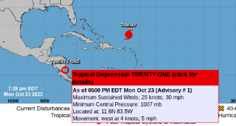
NHC Upgrades Red Area to TD21 Fast Before Landfall........... Hurricane Tammy Spinning You Know Where Maybe Hanging Around For a While. Maybe I'll Go to the Beach to See Tammy IF It Does that Hook Left?
Okay, we have TD 21d!
Tammy doing what most 2023 storms do...
Let's begin with 21.
A nice rich number.
When I went online 22 hours ago I was sure.
It would get designated soon enough.
Pic from 22 hours ago....see?
Nice looking closed system.
What took them so long?
Oh I see this is playing catch up.
Name it before landfall....
Well that is just pitifull.
Trying to be kind here.
Earthnull looked better last night.
I'm going to be honest here. I want the OLD NHC back. You know the one that didn't want to upgrade what looked like a strong Tropical Storm be upgraded from tropical disturbance to tropical depression because they couldn't find a West Wind so put up a Special Tropical Disturbance Warning for Hispaniola that though it does have strong winds the circulation is not there yet but watch out for high wind and flash floods. I was sooooo annoyed they were so hard core about actually upgrading to Tropical Depression. Old saying, be careful what you wish for........now they will upgrade anything ) I don't know if this is agenda driven or just the new normal (did they send Recon in or possibly a dive boat from the coast?) Oh my gosh. I can't believe I stopped watching MNF and Cable News with i24.com (IYKYK) for this ridiculous excuse for a Tropical Depression. Really loved the NHC library, spent hours there researching, reading, writing, photocopying so much respect. Will 2023 Hurricane Season ever end? I want winter and snow or at least sea foam at the beach!
As for Tammy
Scribble Scrabble in the Atlantic.
Cone below.
If Miss Cleo was still alive....
I can hear her saying:
"I see a trip to the beach this Sunday for you!!"
Fingers crossed, hoping, wishing that happens.
I like Wilmington in the Off Season.
Maybe Myrtle Beach...???
I want a hamburger with tons of Israeli salads!
Cold air to the North (Aqua spotted clouds)
Hurricane Tammy definetly there.
Use a magnifying glass to find TD21
Tropical Waves going where Tammy went?
Does one break free?
Long Range Models.
Wow look at that system coming down ..wow.
Tammy doesn't wanna go.
Small close in pop up pops up.
WOW look at that system coming down.
Cold fronts!
I have a Frost Alert for tonight in NC.
Yay ME!!!
I always love the first frost!
Weather happening.
I'd love to see Frost.
Get up early in the morning?
Let's look at the Mimic for Tammy.
A strong cold front is pushing down tonight.
Let's go back to late October 2022.
From a blog post I made shown below.
See the similarities.
Strong cold front same orientation.
Nicole trying to form with quirky models
Similar but different.
I wanna go to the beach and see waves.
Feel wind, see sea foam.
Never saw so much foam as in Nicole.
Last year at Wrightsville.
Awesome day to play.
Sukkos is over, Simchas Torah over...
Could really use a day at the beach.
So... let's see what Tammy does.
Or what I do.
I'm going to go back to obsessing on other things.
sweet tropical dreams,
BobbiStorm
@bobbistorm on Twitter and Instagram.
Twitter mostly weather. Instagram whatever.
This song came to me just now, maybe my mind is extrapolating past Thanksgiving and then Chanukah and wondering what the world will be like down that not so tropical road. My son produced this video, for his friend and then client Benny Friedman whose great Aunt I lived by in NYC in Seminary. Ties that bind are amazing. My son sent me a text message asking where could he get like 1,000 tea lights fast lolol. Target?? Beautiful video and beautiful song and beautiful message. So going with that voice in my gut and will see what happens in the end days of the tropics and will we get to TD 22?? Probably...............
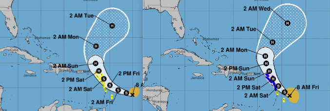
Updated Noon. Tammy Upgraded to Hurricane. Tropics... October Brings Trick or Treats. Do We Get a Halloween Storm or is Tammy the End of the Road? Stay Tuned.
Moving WNW at 7 MPH
275 KM ESE of Martinique!
Earhnull.
Cones look the same
except Hurricane Watch/Warnings added in
10 AM Blog below.
Same info just now upgraded to Hurricane
The cone has not changed much.
Game plan for Tammy is the same.
Tammy will have some impacts in the Islands. As always I say this and I'll repeat it again, a Tropical Storm (especially early in the season or late) has weather everywhere and while it's not a strong, well developed hurricane the weather can be intesnse and locally unpredictable. Elevation in the Islands creates the impact of flooding, flash flooding in some areas so you never laugh it off but this is not September 19th and there is no Major Hurricane anywhere to worry on today.
There is an area in the Carib highlighted by the NHC with a 20% yellow circle for LONG RANGE development. Currently there is dry air moving down into the Gulf of Mexico, a stubborn Upper Level Low in the Caribbean helping to shear Tammy and interference from Norma in the Epac. Nothing is happening this weekend. Long range models take something on an island hopping trip tracing the coast of Central America dilly dallying around waiting for a front to dip down and maybe grab it and sling it out to sea.
There's always an October Surprise in the world, a Halloween Trick or Treat or simply put a wild card as we move deeper into October and November is around the corner in the tropics. The Hurricane Season ends at the end of November officially. With every day we get closer to that end date, and yet often the tropics get a punctuation mark somewhere be it in the Caribbean or off the SE coast close in.
So pay attention, stay tuned but the band is firing up for the theme song to be played, what is called in music an "outra" a concluding song, or a Coda that comes back and repeats a theme heard earlier when you thought the song was about to end and yet the music gets stronger for a brief punctuation to what is in effect the end of the Hurricane Season.
As always I'm waiting to see if we get a trick or a treat.
I'll update later today if anything unusual happens.
Stay tuned....
BobbiStorm
@bobbistorm on Twitter and Instagram
The tropics are a carousel of moist weather combined with atmospheric conditions that either kill development or enhance it. Stay tuned and see what happens. While you do, enjoy the weekend. We are blessed in America to have the joys of Fall and Autumn Leaves or a pumpkin scone. Pick your pleasure. Be grateful! Enjoy it...before the parade passes by.
Location: Miami, Raleigh, Crown Heights, Florida, United States
Weather Historian. Studied meteorology and geography at FIU. Been quoted in Wall Street Journal, Washington Post & everywhere else... Lecturer, stormchaser, writer, dancer. If it's tropical it's topical ... covering the weather & musing on life. Follow me on Twitter @ https://twitter.com/#!/BobbiStorm