Hurricane Harbor

A writer and a tropical muse. A funky Lubavitcher who enjoys watching the weather, hurricanes, listening to music while enjoying life with a sense of humor and trying to make sense of it all!

Sunday, July 31, 2022

Let's Look at 1999 Hurricane Season. Another Season That Picked UP in August & Didn't Stop. Also Horrific Flooding in Kentucky Highlights Dangers of Flash Floods


Phil Klotzbach tweeted this tweet about certain hurricane seasons that had no named storms since July 2nd for a 30 day period. It's common for the tropics to go quiet in July. One year mentioned is 1999 a year I have thought on much recently. 


Busy season.

For weeks through July and into August.
Nothing.
Then 4 Major Hurricanes.


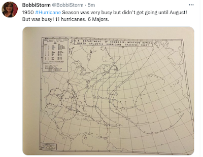
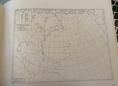
This Iconic picture shows storms in a crowded basin!

Yes most of July, Halfway into August.
Nothing.

Inland Flooding and Floyd ....


The flooding in Kentucky hits me hard.
Flooding is the worst!
Every hurricane season there is this risk....
...people don't get.
Not on a beach near landfall so they think they are safe.
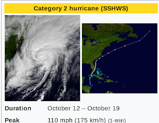
Then Floyd, Matthew and Florence came along.


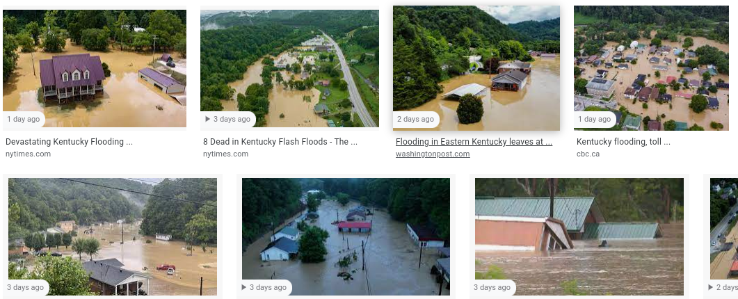
Whether you live in a holler or a river flood basin...
... the risk of Flash Flooding is horrific!!

In 1999 
Miami got lucky. NC did not!

A typical October Hurricane hit South Florida
Actually the Miami area had epic flooding.


But on today's date in history...
...nothing was happening.

That's what I call an old fashioned hurricane season!

June too soon.
July too early.

August Look Out!

Sweet Tropical Dreams
BobbiStorm

@bobbistorm on twitter and instagram
Twitter mostly weather.
Instagram whatever.

Ps 

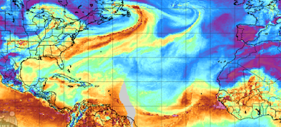
NHC says Nothing for 5 days.


Friday, July 29, 2022

First Storm August 12th. Late Start to 1950 Hurricane Season. Ended up with 11 Hurricanes and 6 Major Hurricanes. Late Start Doesn't Always Mean Slow Season.


https://www.aoml.noaa.gov/hrd/hurdat/mwr_pdf/1950.pdf The above is a tidbit from this link that discusses the very slow starting, but very busy hurricane season of 1950. Nothing formed, not even a weak storm close in or a very weak tropical storm that lasted a few days in early June. Nothing all through June nor July, but then a wave began to show signs of development.  As you can see below, it was a very busy hurricane season. 


Love this book!


Nothing. The A Storm formed in Mid August and they kept forming and forming for the next two months with some late bloomers going into November. 

Never count out a hurricane season because it seems slow in June and July. In August something catches fire, begins to spin and all the discussion on a busted season is buried in a blitz of Hurricane News and often multiple landfalls. 

In Miami 1950 is kind of legendary for Hurricane King, a small compact hurricane that made landfall and is often refrenced to Hurricane Cleo that also made landfall in the same area of the city. 


Actually made landfall as a small....
....but a strong hurricane!
It gets ignored and forgotten by many.


A typical October track for Cuba and Florida!

Stay tuned.
It's not over til it's over!

Besos BobbiStorm
@bobbistorm on Twitter and Instagram


Wednesday, July 27, 2022

NHC SAYS QUIET ... But EPAC is Busy. Taking Turns. Memories of Hurricane Andrew ... Old Boss Passed Away Today... Job I Had During Hurricane Andrew.


Nothing in the Atlantic.
2 Tropical Storms in the EPAC.
 

When the EPAC is HOT
Atlantic is not!
Simple but true.
Usually July is EPAC time.
This is that usual old fashioned sort of season.


Been a long day. I worked for a Rabbi in Miami years back managing his office. Way back, young mother and I'd say between babies but when I gave birth he set up a "nursery" in the office so I could bring my daughter. I did that until she figured out how to hurl herself over the playpen and dump his stationary and business cards all over the floor and decided I was done being a "working mother" lol so left. As a favor I worked again years later for him when he was between office managers. He passed away today at the age of 93 not long after his wife of a lifetime passed away this past year. I'm close friends with his kids and his grandkids have been best friends with my kids, including his granddaughter who was best friends with my little daughter who helped run his office.

Why am I talking on it here?

Hurricane related!!

So I worked there when Hurricane Andrew decided to come to town and threatened to tear everything in it's way down. You know, way back before it took that "dip" to the South saving Miami Beach and Downtown Miami from Category 5 winds! The Synagoue is at one of the narrower parts of Miami Beach, not far from where the Beatles performed at the Deauville on the Ed Sullivan Show. And, it's on a waterway kind of where I imagined the storm surge could pile in on the back side of the Miami Beach. And, Rabbi Weberman was in Israel on a working vacation when Hurricane Warnings were put up for Hurricane Andrew! He said "not to worry" and "lock up the office and go home take care of your family" but if you know me you know...that wasn't happening.  So I moved some things away from the windows, covered some things with plastic. I wanted to do the best I could if the window that faced the bay inlet was smashed or cracked. 


Due West headed straight for us!


Seeing a Category 5 Coming straight at your home...
...place of work and beach a few blocks away is wild.


So we locked up (literally) and I stood there staring....
...at the beautiful waterfront view.
Not that many feet away.
Visions of destruction danced in my head.
Wondered what it would look like after the storm.

I remember almost laughing thinking there's a Category 5 hurricane headed straight for us and I'm reorganizing the office and covering things with plastic garbage bags.... when the whole building could blow away. But, Hurricane Andrew "dipped South" and it did not hit us head on, though there was wild damage nearby on many streets. A day or two after Andrew when we could drive North from our house near 41st Street we went up to check to see if everything was okay. Structures were fine, huge trees were down and in odd spots the street was closed off because huge AC units on Condo Rooftops had crashed to the ground during the height of the storm. The office was okay, a little bit of water had gotten into the unbroken windows through a seam nearby and we clearned it up. Moved things back. The damage we had seen driving North up the beach was mind boggling, but mostly trees down along with AC roof top units. There was beach sand on Collins Avenue still in places from the wind and the storm surge. Really, I was there during Andrew I know. Something you can't imagine unless you have been through a hurricane. My home, further South was in an area that had some odd structural damages. A roof had blown off in the storm and landed on a neighbor's pool; the owners of the home were out of town when it happened.


That was a few blocks away.
As we drove towards the Temple.
Tree trimmers working at the downed... 
....huge Ficus Tree that crashed down.

So while I loved the job and enjoyed chatting with the Rabbi who was really funny and I learned a lot from. I had a little office to myself, a brand new fast computer at a time many people did not have a computer and a part-time job that worked into my life. I was so organized that I used the calendar program on the computer to make menus for the week. August of 1992 started out as one of the most organized months of my life. I even knew what I was making on August 24t!!  But I didn't make it as we had no power for ages and we had a make shift picnic from hurricane supplies instead!

That's the point. Some people die at 29 and others live wonderful, richly filled lives with children, friends, cousins, grandkids and others die at 92 or 93 (the jury is still out on his age) and that's the way life goes.  He was the Police Champlain for the City of Miami Beach...for all the police officers. They were at the funeral home with their cars and motorcycles to give him a police escort to the airport to be flown to Israel for burial by his wife who passed away last year. 

If someone says to me "when did you work for Rabbi Weberman" it's easy to say when Rivky was born, but my first thought is "Hurricane Andrew" as this is how you mark memories and time when you grow up in Hurricane Country and hurricanes often happen.

Sometimes you get lucky and it dips South and other times you don't get lucky because the dip South takes it straight to your house!

Stay prepared.
Don't eat those granola bars and Twinkies!!
I have a strong feeling that the Miami area will see a landfalling hurricane this year. 
Hopefully it'll miss a direct hit but I wouldn't put money on it.
You just never know.

Enjoy life! My best friend Sharon is very ill with cancer currently and she walked every step of the Hurricane Andrew dance with me after deciding in the hot, horrible summer of 1992 that we "WERE GETTING A HURRICANE" and she was right; she'd have bet money on it. Infact someone came by a month before Andrew and offered to prune the huge tree by her picture window facing NE and she gave them money and it was a good thing as that window most likely would have broken being pounded by that tree. 

Be prepared always!
If there is no storm you can eat the hurricane supplies later or donate them to a food bank!

Sweet Tropical Dreams,
Besos BobbiStorm
@bobbistorm on Twitter and Instagram


Tuesday, July 26, 2022

Another July Day Quiet, Enjoy the Quiet. July Standby... We'll See in Real Time What August Will Bring.......


Bubble, bubble, toil but no trouble... yet!

During times when the models don't see anything developing, it's often a close in surprise sort of system that pops up somewhere close in. Yes, that's redundant and I did it on purpose. Models are very bad at picking up small systems, waves twisting up into small storms. And, often close in "heavy rain" can go to a Yellow Circle when models begin to see close in development. And, it's also possible nothing forms until some beautiful African wave comes together on August 24th at the latest.  Colin went from "nothing happening" to "something happening in seemingly hours. 


June too soon.
July too early.
August come you must....
...September Remember.
October all over.

(it means after Halloween usually)
That's the old weather rhyme.
CLIMO driven.
2022 may just be that sort of hurricane season!

I started two different blog posts today and trashed each of them. I could share examples of busy seasons that started in August and I can tell you of busted forecasts for the hurricane season. They are long range forecasts based on certain factors, yet weather happens in real time and sometimes things change. 1997 was forecast to be a very bullish season and it went into hibernation like a bear when El Nino exploded. Except for a couple warm ripples the map below doesn't show an exploding El Nino so throw 1997 out as a possible analog year. 


Blue is cool... red is hot.
Warm but not hot temps in Atlantic by ITCZ


Still nothing happening in the tropics as per NHC.
Nice wave by Africa.
Inverted trough over SFL
Another trough over VA and the Carolinas.


A beautiful kick ass wave models are ignoring.
Waves get no love unless models love them.


Another look at the SAL and the Wave.
White wound up wave South of the strong SAL.


No strong model support and they see nothing. No real wind there currently and on Earthnull at the level that matters it isn't closing off. But it does take bites out of the Saharan Dust, bite by bite. Every little bite out of the dust helps. At some point MJO or no MJO, something happens. 


NHC doesn't mention it.
But it's getting awfully purple.


Waves to the N over FL.
A lot of moisture in the GOM
Loving that linkage from Jamaica down to Trinidad.

The water is warm, shear is low and at some point SAL goes away and CLIMO gets its way. The very busy 1996 Hurricane Season sprang to life with real, intense storms after mid August. Happens often. 


Just an example.
1996 was kind of busy.
All those long, orange bars are Major Canes.


1996 is not an analog year.
It's just an example.

Tomorrow or later today I'll talk on some years when activity in the Eastern Pacific was way above average early on and way below average in the Atlantic. That happens often, one basin reigns and another basin is dry as dust. 

Sweet Tropical Dreams,
BobbiStorm
@bobbistorm on Twitter and Instagram
Twitter usually weather, Instagram whatever.


Sunday, July 24, 2022

Hot Dry Summers. Hurricane History. 1980 & 1954. Yet, 2 Very Different Hurricane Seasons! Purple Blotch in the Atlantic. Huge Tropical Wave. No Yellow from the NHC.


So no yellow but got purple.
Different maps but worth discussing.


There is a wave complex.
Trying to close off in some way.
SAL is strong to the North.
Not a lot of moisture to work with.....


You can see it well on the Mimic.
A lead wave near the islands.
A bit of moisture but no wind, no circulation.
Front hanging there in Atlantic.
Strong high pressure to the North.
Everything gets sucked dry but heads West.
At some point friendlier warmer waters welcome...
...the exhausted tropical wave and it can get energy.


Lots of waves, one of them will do the deed.
One will flip the switch ... 
The big purple splotch says a lot.
A yellow circle would say more.


Google my blog and you'll see I have talked incessantly on this topic. No two hurricane seasons are the same, yet they have similarities. Kind of like Cabbage Patch Dolls. I was always skeptical, I mean the two red heads here look awefully similar...yet different. 

Every meteorologist I know who is worth their weight in weather history is harping on this summer being like the horrific, hot, heatwave filled summer of 1980. It doesn't mean that this hurricane season will be the same. But it's worth remembering how that turned out. Obviously, lots of fish storms at some point. And, a hurricane that had 190 MPH winds. I missed that season as I was in LA studying up on earthquakes, geology and old Spanish Land Grants. But I remember the images of that hurricane.  


This is not the hurricane season that many are predicting.  There's been talk that a strong ridge could push a hurricane into Texas, yet most talk on dangers to Florida and the East Coast all the way to the Canadian Maritimes.  So the heat complex is similar, yet different.  


You can Google it and give Wikipedia some money!
Oh since 1954!


East Coast loaded!
Some fish storms.
Carol, Edna, Hazel did NC!!
Some trash storms but didn't come alive til late.


Orange/Red Memorable Hurricanes.

A lot of mixed signals with this 2022 Hurricane Season. Reminds me of 1992 but 1992 was El Nino but Lord was it hot in Miami, such a hot summer, one of the hottest summers anyone remembered in ages. 

When there's a vacuum, Mother Nature tends to fill it up eventually with a huge hurricane.

Stay tuned. It's not over til it's over. About the time mets start fighting online about it being a busted season and the forecasts were wrong, suddenly the flip is switched and BAMN there's a hurricane somewhere.

Waiting on a yellow circle at this point.

Watched NASCAR a bit, because no hurricanes and no football, as I needed a distraction. It was feels like 105 degrees in Raleigh today, thundered, rain threatened but went elsewhere. One of my best friends is sick in Miami (spent time together last week) and time will tell what happens. Being honest. We've talked a lot of football and hurricanes together over the years. The silence in the tropics has been deafening.

Won't last forever.

Besos  BobbiStorm
@bobbistorm on Twitter and Instagram
Twitter usually weather and Instagram whatever... 

Ps Some vintage footage from the late, great Jim Leonard! Hurricane Allen!! Old school style and showing it as I think this season is an old school style hurricane season. Sorry if there's any typos I'll fix them later, thunderstorms that hover but don't produce rain give me headaches!


Wednesday, July 20, 2022

Tropical Still Quiet. I'm on Vacation with Family and Sneaking Peeks at the NHC Main Page BUT NOTHING... Soon There Will Be Something. Stay Tuned!


5 Days nothing expected.
2 days nothing expected.
Yes, nice wave off of Africa.


At some point one of them develops some.
Til then they are juicing up the atmosphere.
Fighting off the SAL.


The story is like this....

The MJO is supposed to show up around the time that CLIMO dictates the tropics come to life. So, having a reinforcing MJO on top of other factors is relevant. There are fronts still as you can see hanging off the East Coast and a kick ass tropical wave off of Africa. You can see the last beautiful wave at the entrance of the islands being ripped apart by shear that is there in July. In less than 2 weeks it's August. SAL lessens some, shear weakens and tropical waves move West until they hit that place where they come to life. 

I'm in the Miami area visiting numerous family members, busy, busy, hot, hot and as my brother said yesterday at lunch "this is hurricane weather" and being old Floridians back to the 1800s we know hurricane weather. When I say "hurricane weather" I don't mean a hurricane is about to develop, I mean that this weather pattern will be a magnet regarding track once tropical waves become tropical storms and explode into hurricanes.  You can see in the image below how the SAL has moved across the Atlantic and is lingering around Florida and there are pockets up near the Carolinas.


The empty areas in the red SAL are the kick ass waves!
Where SAL goes in July....
...hurricanes follow in late August and September.

It's a process as old as time.

I know, I've said this before and it sounds like "rinse and repeat" but until the tropics come to life the usual deniers will continue to deny we will have a busy hurricane season. I don't have time fot that, I have places to go and people to see before going back to the Hot Carolinas who will be having a Heat Wave when I get back. Joy. 

Keep checking in, because as soon as the NHC puts up a yellow 10% or 20% I'll be back to blogging daily and watching the models. Til then, I'm taking my tropical vacation. My kids live in very tropical places... 


Besos BobbiStorm
@bobbistorm on Twitter and Instagram.
Twitter mostly weather and Instagram whatever.


Friday, July 15, 2022

NHC Says Quiet. Purple Splotch Up on a Westbound Wave. MJO About to Flip. Tropics Should Heat Up Soon. August Getting Closer Every Day. Only a Matter of Time.

NHC says nothing for 5 days.

As there are no yellow circles on the NHC page, I like to bring you the Purple Splotch page which to me is more reliable at times. For example, the whole entire time the NHC had the yellow thing hoisted in the Northern Gulf of Mexico there was never a purple splotch there and note it never developed!  If it's going to have chances, it shows up in purple (usually) before the yellow circle appears.  Speaking of tropical waves and purple splotches, here's the purple wave below. Looks a bit like some 1960s Martian Spaceship on a cartoon show.


I'm not making this up.


Anyway it's something to watch.


Stalled out front ...top middle.
Off Miami coast moisture trapped in the ULL.


This is an ULL not a hurricane.
But they have similar structures.
I love to call them Ghost Canes!


Upper Level Lows carry with them a myriad of weather possibilities, there is a dry side, a "dirty" wet side where moisture from old waves sometimes gets caught up in their ghostlike circulation. On rare occaisions, that trapped moisture caught in it's circulation can work it's way down in the atmosphere, the ULL fills in and a low end tropical system tries to form. Usually, they just do their thing and this one has come a long way from the middle of the Atlantic. It traveled quite a distance and I knew it would probably be about where I would be on a planned trip from NC to Florida for a family event. Summer somehow always brings family events, weddings and birthday parties and various other occasions that have yet to happen. 

So what's with the Upper Level Low tracking? If you are a newbie here, and you probably aren't, it's worth remembering that ULLs can tear up a budding tropical storm as the shear can rip them apart inhibiting them from really getting going. On the other hand, if a traveling ULL moves into the right position rather than rip it apart it can really enhance the convection and help a tropical wave develop faster into a tropical storm or hurricane.  Either kills it or enhances it and everything depends on the location of the ULL to the tropical wave. Remember that down the road when we actually have a tropical wave worth talking about.

In this case, as this huge ULL swirled across the Atlantic it managed to pick up some moisture that became trapped inside it (mostly on the right side) and that added moisture will connect with a front stalled out across Florida enhancing the precipitation and amping up the atmosphere where more severe storms will form in various places. Sounds nebulous, but it's one of those things that evolves in real time. There's nothing there on your radar, it looks sunny and then suddenly you hear a crack of thunder and think "where the hell did that come from" and a few minutes later you see where the hell that came from. Mike, near Tampa, had something like this happen to him the other day and he spoke about it in his morning broadcast. 


Yesterday traveling Southbound on I-95 that semi dead front came to life in magical, meteorological ways and we had nonstop lightning, hail and a crazy long wall cloud for a wild line of storms near Savannah. 

When the "yellow thing" was trying to form in the Northern Gulf of Mexico, there was a small Upper Level Low in the GOM that created interference for the wanna be low and yet amped up the atmosphere on the West Florida Coast like crazy. Storm chasers hit the road, wild storms formed and yet the Northern Gulf Coast basically got normal summer rain.

Another point here is that often tropical storms and hurricanes follow the same track that Upper Level Lows have traveled before them. Also, as Saharan Dust makes its way West across the Atlantic if you plot out the movment of the dust and the locations impacted you will notice over the next month or two the early hurricanes tend to trace those same tracks of both the Upper Level Lows and where the Saharan Dust goes. I say this from watching them both over time. At some point something changes and the strong High collapses some and there's a path way for a Fish Storm vs an "oh my God it's gonna wipe out the whole East Coast" sort of Cone. To everything there is a season and the season currently is shaped by the very strong high that will keep propelling SAL and tropical waves westbound across the currently quiet tropical Atlantic.


Orange snf Red is Saharan Dust.
Wave in center of Atlantic bit a bite out of the dust.
That ULL is to the West of the edge of SAL.

Each wave takes another bite out of the Saharan Dust and wave by wave by wave the SAL lessens and the waves get stronger. The water gets warmer day by day and eventually provides an edge to the wave that allows it to develop a bit more, rather than fall apart chocked off by the SAL that strangles it some. There's a rumor going round that the cavalry is coming as the MJO is about to flip!


There are positive conditions and negative conditions in July in the tropics, it's a mathematical equation for possible development or a busted forecast. Soon, the MJO will move into this region and SAL will lighten up it's dusty load and a tropical wave will have higher than average chances of development.


Then we will get better yellow circles and deeper purple splotches and finally we will get something going. There are definitely waves, waiting to travel Westbound over Africa. Tropics may not be active, but the storms over Florida today will feel very tropical!

Stay tuned.

Besos BobbiStorm
Sweet Tropical Dreams,
@bobbistorm on Twitter and Instagram
On Twitter mostly weather and on Instagram whatever.

Enjoy.... and to be honest when I was a kid they didn't call it SAL they called it various names such as African RED Dust or Red Saharan Dust which made it sound like dust from Mars or some far away place was messing up our Miami air and a few times it was so bad my father's white impala was covered with Reddish Orange Dust the way a Chevy Spark in Raleigh turns yellow when the pollen pops. Saharan Dust so thick you could write your name on your father's car when he wasn't looking!


Mike was listing old TV shows he loved yesterday.
So I guess it got stuck in my head!