Hurricane Harbor

A writer and a tropical muse. A funky Lubavitcher who enjoys watching the weather, hurricanes, listening to music while enjoying life with a sense of humor and trying to make sense of it all!

Wednesday, May 31, 2023

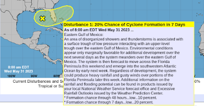
UPDATE 8 PM Invest 91L in GOM. Hurricane Season Begins at Midnight. GOM Yellow Circle 20% Battling Strong Shear. African Wave! FL Getting Tropical Rain on June 1st - Tour of Spaghetti Models Has Links for Hurricane Prep!


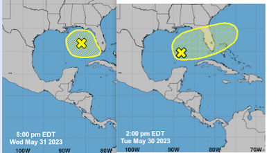
Current location on the left.
Yesterday on the right.
So far it's lost latitude and is further N in the GOM.
It's battlilng shear...
There is dry air moving in...
Models show it almost anchored in the GOM...
..a slow drift to the SE is expected by the NHC.
I wouldn't bet on it yet personally.

As it's an Invest now we have better models.
More investigating the situation.


Strength forecasting keeps it low.
Possible window for development.
Still 20% in the 2 day and 5 day.


Red/Black/yellow is DRY AIR
Where's 91L?
It's there...


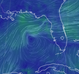
The lines close together show the shear there.
Note there's the unnoticed low by the Carolinas too.
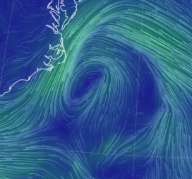
.

Just hanging out.
Funneling cool beautiful air into NC

So where's the weather?


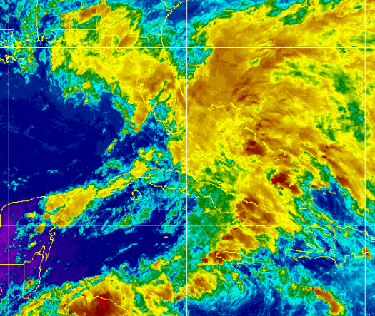
Everywhere else......

It's common to have messy disturbances on June 1st.
In the GOM... right sided
Let's see what it looks like tomorrow.

It's there.
In 4 Hours the NHC 2023 Hurricane Season begins.
Have you made a plan?
Please make a plan....


It's a good place to start, unless you are an old timer and you know the drill... 

There is no reasoning with Hurricane Season as Jimmy Buffett knows well, so as the song goes "squalls out on the Gulfstream, big storm's coming soon" take a rest in your hammock but only do that AFTER you have done what you got to do and if you did then you will definitely need some rest. 

Ain't no reasoning with Mother Nature.........

Besos BobbiStorm


Compare the discussion from this morning below...
...with the smaller yellow circle in the GOM at 8 PM.

* * * * * 


Always start at the beginning with the NHC
They are the bottom line.
20% in 7 days....
...battling strong shear.
Storms blown off towards Florida.
What begins in GOM may not end in GOM.
Keep watching.
Keep prepping those Hurricane Supplies.
This is only the beginning.

Going to stay relatively short today word wise here as I went long yesterday. There is an area of interest (AOI) in the GOM, but know it's being sheared wickedly and the result is the storms will be blown East with the shear towards Florida and that will add fuel to the fire of the Rainy Season already in place there. Also, Cuba and the Yucatan will get strong thunderstorms while the center like area, the "vort" as Dabuh calls it often is anchored for now in the GOM. Going to post some images from Mike's Weather Page aka SpaghettiModels.com as a guide as it's good to know the huge site and appreciate the many links he has there for you all to use.... use them all!


This is EURO Thunder Storm model on Windy.com
Camera filter on - my way of showing you..
..they have the best webcams around!
Take a tropical vacation to any beach any time.

Models are all over the place and as always with systems such as this we watch the satellite loops in real time and wait for the next model run. While I can't promise you a Tropical Storm named Arlene on June 1st, I can promise you lots more tropical rain storms over Florida from the nearness of this quasi tropical disturbance. Acting more like a subtropical disturbance today as Havana getting more weather than the actual area we are watching, but it's all about the weather in cases such as this one. Ironically if it pulled together suddenly into some neat little tropical ball worthy of a name, the result would be that less people would be impacted by the worst weather than is forecast with it being sheared apart currently and everyone to it's East getting rain.


Speaking of odd models, the NAM shows this for 6/1
Perhaps it's trying to find a spot with less shear?
Then on Friday it moves back into the GOM more.


That's as short term a model as it gets!
While ppl love to make fun of it...
...it sometimes shows details valuable.
No 1 model is always right.
As we see below......


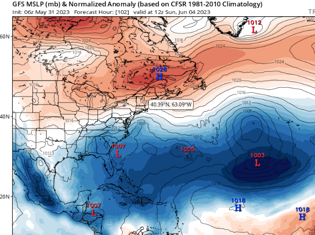
GFS does nothing much with it.
Takes an area by the Yucatan S.
Shows L off SE coast (logical)
We won't talk about the rest...of GFS.


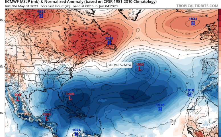
EURO shows it come together in GOM finally.
Move fast thru FL and the then...
Florida Straits gets a chunk of it...
..Low ends up E of Florida.
Carolina Low goes out to sea.
Low pressures in ATL like GFS actually.

Icon keeps it in GOM longer.
But eventually gets it into the Atlantic.

Nuff said about the 20% AOI in the GOM. Honestly I could write forever on anything, but this is all up to the area itself to see how it handles the shear, where it goes and then what it does. It's an evolution that can be like watching paint dry on the wall... unless of course you believe the NAM. 2023 is a year of mixed signals, in years such as that it's not always easy to rely on models, analog years or forecasts. Remember that.
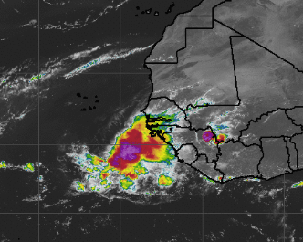

Oh Look at Africa!
That's one sexy Mama wave that departed the coast.
Has a small purple splotch for today tho...
....should cool down a bit the next day.
Time will tell as always.
One heck of a wave for last day of May!

Lastly, these images are from SpaghettiModels.com a site I love and spend a good amount of my time on. No, I'm not paid by Mike to say this ........we've been friends a long, long time and it's been awesome to watch his evolution over time, learning every year better ways to explain, advise and give heads up to his viewers, fans and friends. Okay, my blog is listed at the top of his page and I'm very proud of that as who wouldn't want to be proud of being on one of the best, most popular tropical sites around.


Top left models. 
Sites with relevant information.
On the right side his store.
Buy a shirt...I will when I figure out which one.
Because I like V Necks and I'm indecisive ;)


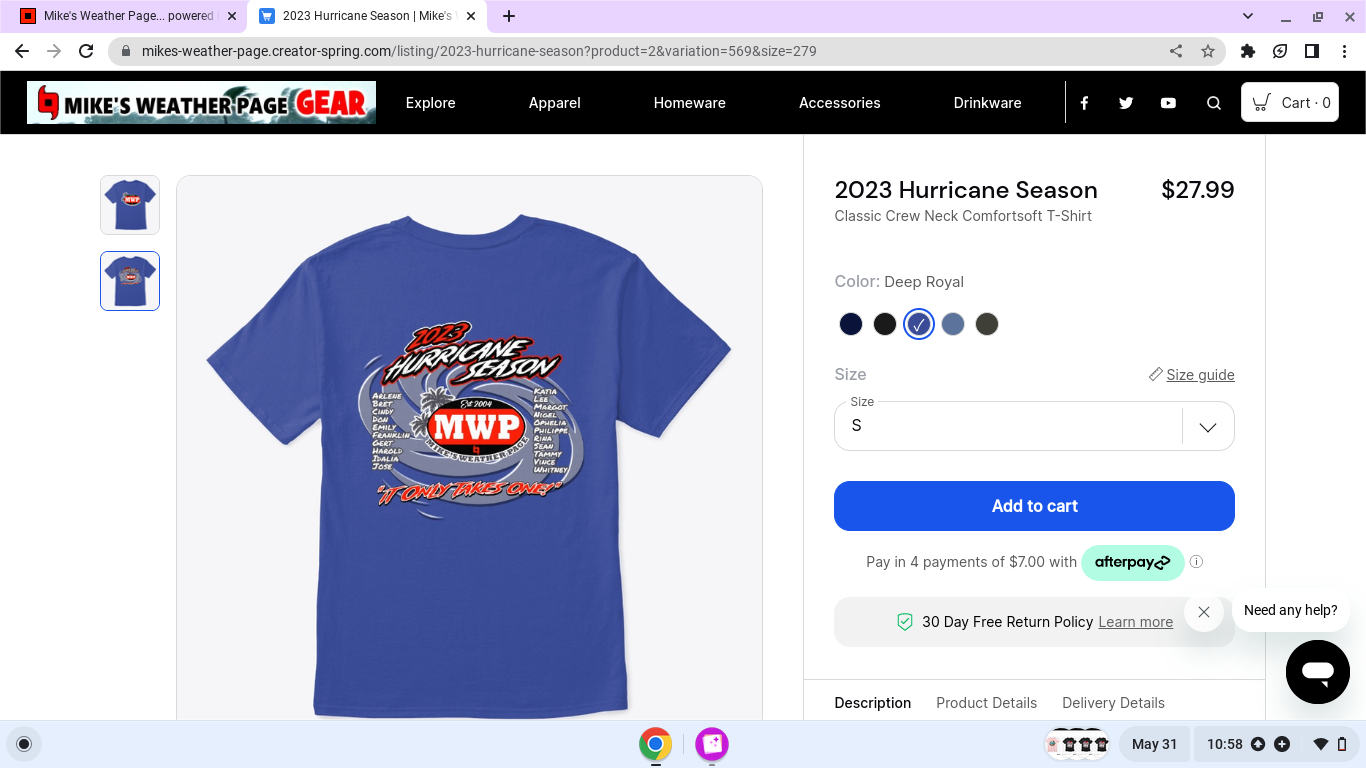
Fantastic shirt with all the names on it for 2023!


My Purple Splotch @atch sites are on his page!


One of my fav parts of the page.
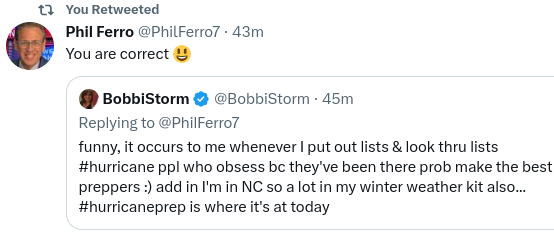
There's a great scroll from Twitter.
Honestly fast news from the best!
And some you might not follow...
..easy to scroll fast. Love it.
Even if you're not on Twitter...
...u can follow the tropical news!!


5 Day Rainfall on left....
...5 day forecast on the right.

More to come tomorrow.

Be prepared.
Be a Hurricane Prepper!


Phil Ferro is my Go To Source in South Florida.
He's the best. 
And an incredible human being.
No he doesn't pay me ;)
He's awesome,  answers questions on Twitter 
No ego, no attitude just the INFO.
INFO is what we need in Hurricane Season!

Sweet Tropical Dreams,
BobbiStorm
@bobbistorm on Twitter and Instagram
Twitter mostly weather and Instagram bit of whatever!

YES the waves over Africa ARE starting early this year!


Tuesday, May 30, 2023

Yellow Circle in GOM 20% in 7 Days... Crosses Florida and Then What? There's a Chance...... Moisture in the Carib, Bahamas and Florida Will be Rainy. Does June 1st End Up with a Named Storm? Maybe, There's a Chance. Just a Chance....


10% in the 2 day - 20% in the 7 day.

I waited til 2 PM to write the blog.
I'd have bet on a yellow circle...
...and I'm not a gambler.
I only bet on sure things.


A trough and an Upper Level Low...
...mixing it up in the Gulf of Mexico.


Yellow circle just a matter of time.
Convection shows up here well...
...so does the shear there.
Pushing off to the East fast.
Oh...Florida kind of in it's way.
Obviously.

I've mentioned this here and on Twitter often, this pattern of convection flaring up in the Gulf of Mexico, dousing Florida with tropical moisture and once in the Atlantic over the Gulfstream it has a chance of developing into something. I say something as it could be a tropical system, subtropical system or another Coastal Low. But there's a chance......

Every weather fanatic or chaser online today.


Yeah....


You can almost connect the purple blobs can't you.
We are still in frontal territory weather wise...
..and EPAC is about to pop eventually.


2 Low pressure areas are easily discernable.


In the GOM you can see a sense of circulation, yet all of the weather is displaced to the right as there is shear there pushing the storms off towards Floida. The area to the East of Florida is moist, ready and waiting... has it's best red dress on with matching red high heels! Down in the Caribbean South of Jamaica you'll notice there's also convection with bright color kicking up storms there, by Cuba and on the tip of the Yucatan. Do you get the feeling the horses are moving into their places for the race?

Thursday is June 1st.
Let the games begin as many like to say...
...or been saying since 1997 and before ;)


But which horse wins the race?
Which area has the best chance of developing?

You have to start with moisture and pressures lowering to get something going. However, shear gets a huge vote as does Saharan Dust. Shear knocks the tops off the clouds and shear sucks the moisture out of them. Just because we have areas to watch does not mean we definitely will have development. But, there's a chance, the point of today's blog is to let you know there is a chance and the Caribbean is very soupy, wet, moist and ready to party. 

Oddly the EURO is more bullish than the GFS in the short term, yet the GFS shows another Deja Vu Coatal Low closer to the coast while the EURO sees something out in the Atlantic with deepening pressures and a chance of a name. 

Name game is not easy but we are just watching the pattern and models spit up possible ever changing solutions every day so keep an eye on it, know Florida will be rainy (so will be the Caribbean if you're cruising) and it is possible currently that there is a chance the start of the Hurricane Season kicks up with some action from the NHC on a possible tropical like system. Lots of IFS ANDS and MAYBES.


Florida stays soupy caught in the Rainy Season.
Don't say I didn't warn ya...
Red and purple on this map for the next 5 days.
Means storms everywhere at any time.

Stay tuned regarding tropical development...
...vs rainy season in Florida.

Watching...

BobbiStorm
@bobbistorm on Twitter and Instagram

Ps What do we actually get?
Rain or a named storm?
Cheeseburger in Paradise??


or just a rainy day in paradise........


Monday, May 29, 2023

Online Videos and Discussion on Coastal Low and the Cruise Ship and Why It Wasn't Upgraded to Named Status. Models Show Deja Vu Storm Possible Next Week. Memorial Day Weekend...


For what it's worth here's the official NHC page.
Being honest, a lot of controversy currently...
...after the debacle of the Coastal Low 10% to Zero.
 We aren't even officially in Hurricane Season..
...and everyone online is 2nd guessing the NHC. 

The problem with saying you can forecast when something will form within a 7 day period, despite often the 5 day period missed many pop up storms close in, is that the NHC goes on record saying that nothing is expected to form and suddenly something starts to form and they do prefer when their forecasts verify. Do they stick with the yellow circle they brought to the Prom or do they change things up in real time explaining close in, home grown Lows are hard to forecast that far out? 

After a recent upgrade of a "low" in the Atlantic in January in post season analysis, they ignored many models and satellite imagery showing this "Coastal Low" could attain a stronger intensity and be a sort of Hybrid Storm/Low worthy of more than a mere "we see it 10% yellow circle" and reminding people surf will be high and there could be Gale Force Winds. Long sentence for a big mess of controversy on not naming or designating the system in the last week of May that had winds of 80 MPH (short gusts, long gusts, not sure but measured) and surf so high that it battered badly the Carnival Cruise ship that was not so fun as it continued on in high surf towards Charleston.  

My brother, who cruises often, he reminded me that cruise ships HATE losing time and not sticking to schedule. I'd say it's his one complaint and yet he complained in the past when they missed docking somewhere due to a storm. If you are going to travel on a floating hotel close to hurricane season you may miss a Port of Call, it's only logical.  Once we missed putting in to dock at Nassau and spent an extra day at sea and I personally was thrilled because coming from Miami ... Nassau looks a lot like some of the Florida Keys, while whole day at sea was awesome.  Plus we were near the Tropical Storm, but safely away from it thanks to NCL, and I got to see the coast of Cuba as we had special permission to take the Old Bahama Channel just offshore. The mountains were beautiful, the extra day at sea was a treat!


Amazingly the NHC posted this on May 25th...
Cute pic that came back to bite everyone.
Being honest, not pointing fingers.


Mike posted this earlier and on Twitter.
One of his MVP followers was on that ship.
They were not happy.
Obviously they had named storm conditions.
Wild waves, 80 mph winds cited.
Coastal Low tightened up on approach to land.
Who knew?

Many meteorologists online debated the fact that the possibility of it reaching named storm status was not logical as many good models estimated it would come together more than just a "coastal low" and as it was the week before the Hurricane Season, it was logical to give it a higher percentage chance (just in case it develops more, as it did) and yet this was the first yellow circle while they are touting the "we can forecast 7 days out" which is good and true often (they nailed Ian's development) but not as easy in a set up as we have this year with fronts still dawdling on the maps and it's 64 degrees on Memorial Day in Raleigh not feeling too Summery. More so the time period when we flip from La Nina to El Nino often opens the door for models to be difficult to rely on far out as there's a tug of war going on between what has been the trend and what will be coming down the road. 

Kind of a worst case scenario for forecasters who want to use their new 7 Day set up in the Tropical Weather Outlook. But, there's a need to remind the public that as good as we have gotten... we still have a long ways to go ...and if you live say in Florida it's possible at any time a system could pop up that was missed early on. And, I'll add storms with small centers are infamous for being missed early on by models and the NHC. While the weather was over a wide area from this "Coastal Low" the center that closed off tight was small and the stronger winds were in a small area, a perfect contender for a named system that gets missed early on. 


You be the judge of how bad it was....
...but know there were injuries.
I'm sure they will compensate ppl with a new cruise...
..or a hefty discount on their next one.
And, they can easily blame it on the NHC.


This is the problem with being the NHC and having a good Government Job where you have to tow the line and go with whoever makes the final call as the buck stops there as they are the bottom line. And, I'm being clear here that the Tweets have been from well known, wise meteorologists who know tropical meteorology and feel they should have done more than put up a 10% yellow circle. I'd easily say the people complaining far outweigh those who are defending the NHC.

As for me......

I seriously hated the way it's been for several years where storms were declared hurricane after landfall (complaining recon may have missed a hurricane force wind...sic) and naming systems that blew up and survived for less than 24 hours as usually we expect a system to be there for at least 24 hours if not 48 hours (old rules I know) for it to be recognized as an entity worthy of attention. We don't just upgrade any blob of convection in the tropics that looks as if it has a spin to pad the numbers for a busy season forecast. The older crew at the NHC Sheets/Mayfield were extremely tied to rules and conservative before making a tropical disturbance a tropical depression. The recent crew in charge a few years back during Covid upgraded almost anything that had colored convection and spin.  You need caution and it's good to be conservative, yet at the same time you can't be so tied into the previous foreast verifying and being honest that as much as we know, we don't know everything yet and tropical systems are prone to pop up especially in home grown areas.

It's Memorial Day today so I am leaving the Grammar Rules at home and just saying it as I feel it as if we are having an honest conversation.

Last year's work insisting IAN would form in what had been a lack luster year intensity wise and waiting tediously for it to finally come together and pointing to that part of the Gulf of Mexico near Florida was a huge win for their ability to sniff out a Major Hurricane a week out when there was nothing but some clusters of clouds. Again, it's easier to do that with Tropical Waves than it is development at the tail end of a front or with an Upper Level Low that works it's way down to the surface. 

Coastal Low May 2023 was a worst case scenario for nailing down intensity. Perhaps Carnival Cruise Lines felt they could keep to their schedule and blame it on the NHC who had just been there and never said it could possibly attain named storm status and why mess up their schedule for a little bit of nasty weather without a designation? It wasn't even an Invest....

This reminds me of the mess with Joaquin and the El Faro that was lost at sea. Something about this area, we can call the Bermuda Triangle but be aware I'm partially being playful in that weather changes fast and forecasts are often busted close in to Florida, Georgia and the Carolinas.


Regarding Joaquin, originally there was much talk it could be a problem for the Carolinas or Florida... a frontal boundary was nearby to the North but instead it wandered about aimlessly. Charleston was POUNDED with what was called a "FIREHOSE OF MOISTURE" with some street flooding being I suppose caught between the frontal boundary and the intensifying hurricane. It's a difficult place to forecast as there are so many variables early in the season and late in the season.

The Coastal Low that crashed the cruise ship in late May and Joaquin a late season hurricane that sunk the El Faro where 33 people died are perfect examples of the difficulty in forecasting perfectly what will happen with fickle tropical systems early in the season and late in the season seven days out... especially close in.

Tomorrow we will talk about the area that probably should soon get a 10% yellow circle as models are forecasting trouble again for the same area of Florida and the Carolinas, never forget Georgia.

Hope you have a good day today. I'm sure Carnival Cruise lines were try to make it up to the passengers, though Mike points outs always that's why they use Norwegian as they have the best reputation in the business when he does his MVP Cruise Parties and sails off into the horizon with some of his weather and sailing fans.


GFS above in the 7 day currently...
loves Lows usually.
vs Euro that's usually more conservative.


Stay tuned.
Will discuss it all tomorrow.

Again I feel for the NHC that is trying it's best and it's way better than it was when a Category 4 Hurricane swept across Miami Beach with little warning other than a notice in the paper the day before a storm might be coming and the head of the Weather Bureau running from door to door to warn people. Many people died. And, they had more warning than the town that was wiped off the map in the 1856 Last Island Hurricane. Give thanks for all the NHC does. 


As for the Carnival Cruise Line that has a long history of troubles such as this for not waiting to put into port and yes I'm sure many on board would scream and complain as loud as those complaining online. Easy for them to blame the NHC but if you Google Carnival Cruise Line and Storms you'll see what I mean. If you cruise in late May through November you always have to know tropical trouble can pop up suddenly. Is what it is...  It is the risk you take and you hope for the best when you take a cruise in tropical waters.


For Jim Williams, a good friend who always complains I don't give my bottom line thought:

I think the NHC should have raised this to more of an Invest status, a higher percentage chance of development even if they had people complain it was within their 7 day window of nothing happening earlier in the week. Often we get storms that don't fit neatly into a specific label and sometimes it's good to open that door up to the possibility of more rather than holding the line and going too conservative.

Or put out a Special Tropical Disturbance Advisory to cover the storm that trashed the cruise ship and Memorial Day Weekend, without actually naming it and leaving the door open to re-evaluate the situation in the off season. 

Nuff said.
Have a good Memorial Day and remember some of our earliest Hurricane Directors and Tropical Weather Experts were Veterans that worked on flights into tropical weather during WW2 in the Pacific and back at home they went to college and studied meteorology. The work they did while the Armed Services tried to tackle the problem of losing soldiers to Typhoons vs actual battles in the Pacific Arena led to what we do today with Hurricane Recon. 


Besos BobbiStorm
Putting on leggings and a cute short skirt and my favorite V neck shirt and grabbing a hoodie in case it rains in Raleigh later in the day, the possibility is there.

@bobbistorm on Twitter and Instagram
Ps........any typos sorry I'm on vacation today! 


Sunday, May 28, 2023

Coastal Low Today. Models Replace It with Another Coastal Low. Pattern Set Up for Tropical Trouble with Coastal Cruisers in an El Nino Year! A Rant on the Seaweed of My Childhood! Venetian Pool Coral Gables...


Using this filter on Windy.com to show you that you can go to any weather cam along the map and get a fast, seamless view of the beach, mountain or watch sunrise somewhere far away to your West. There are lots of weather cams around, but often they go wonky when you want to use them and it's frustrating. It's one of many filters that come with the package if you subscribe to Windy.Com and I do. Not expensive, crazy cheap sales and you get a lot for your money. You can see there's "rain" over my house in Raleigh this minute and it's delightfully 59 degrees. This is the second coastal low in a set and if models are correct another one will develop that will have better chances of light development in what is a favorable area for tropical systems. Luckily the water is not so warm here yet as we are having a plesant cool start to summer in this neck of the woods and I'd like to keep it that way as long as possible if my wish counts. Born and bred in South Florida I have had enough hot, humid weather to last me a lifetime or two so cool mornings with light rain make me feel refreshed, happy and alive! In the mood to write this morning, while I listen to the rain with the windows wide open enjoy the long blog or just look at the pics and listen to the music!


Current image this morning.


Zero percent chance of developing.
100% chance of rain.

The current system as seen from Myrtle Beach, one of my favorite beaches is below. My thought being you can probably get a good deal on a room tonight there, but do I really want to drive 3 plus hours to get there or just hang out here at home? Loving the feel of the weather today too much to go anywhere except maybe out for Ice Cream or the Farmer's Market for some fresh produce.


The incredibly beautiful coastal low (with zero percent chances of forming) may be followed in the not so distant future if models are correct and remember this is the second coastal low so far that has formed and strolled up the coastline after forming down in the Bahamas.


EURO for June 4th at 8 PM.
Third Coastal Low in the same spot!
Sure looks the same ...doesn't it?


Strong weather in 1st week of June.
June too soon as the saying goes.
What is non tropical will eventually....
...become tropical systems along the coastline.
Something to think about.


Compare Tuesday, June 6th above..
with the current signature today below.


That's a pattern.


Now let's talk El Nino.
It's here and it's growing.


I cut the image above down to a smaller image from the usual larger image we look at that shows the whole Atlantic and most of the Pacific, it's distracting and I want you all to focus here. Most people when asked will tell you that El Nino happens out in the Pacific (to the West) somewhere South of California and it grows West into the Pacific. The reality of the map above shows you El Nino forms due South of Biloxi, Mobile, Tampa and the Carolinas if you move your eyes on up the coast. Many Americans think South America is South of California, when most of Florida is West of most of South America. This map shows the reality well and it also shows how as El Nino develops the shear associated with it shuts down the Caribbean for tropical development usually.  The problem is that the stronger tropical waves survive and get up into the Gulf of Mexico closer to land where shear is barely there and can intensify close in before landfall. Or development occurs off the Florida coast near the Bahamas and IF there is a front calling to it ...it pulls North towards the Carolinas to run away with the front. Or it slams into Florida if there is a blocking ridge. El Ninos lessen the total number of named storms but they also have delivered some of the worst Major Hurricanes in history to places that felt "safe" due to the lower number of named storms in the slower El Nino Hurricane Season. 

While the Deep SW Caribbean may get shut down by the growing El Nino, it will seed systems that will develop elsewhere. On the most basic level we can say "stormy weather" moves out of the Caribbean into friendlier waters where there is less shear and the danger of close in development rears it's ugly face when we have this pattern. What this means is it will be way harder for tropical waves moving  West into the Caribbean to develop and slam into Central America. If the shear is strong it'll protect the Islands and tropical waves will pull North of the Islands or become Fish Storms out in the Atlantic. There are always exceptions to every rule.

There are 3 areas that need to pay close attention this year in particular. 

The first area includes the beautiful cities along the Gulf of Mexico facing out over the blue water that'll be way warmer down the road than it is now and can support fast, rapidly intensifying tropical development. 1969 was a weak El Nino and Hurricane Camille began as a long tracking tropical wave that was unable to gain traction in the deep Caribbean but as it pulled North it found it's sweet spot and it slammed into the Gulf Coast and dragged it's heavy tropical rain signature across a good part of North America. 

The second area is the state of Florida that sticks out into the water as if it's begging to be hit by a tropical entity. It's also open to development from tropical disturbances that cross Florida from the West and end up over the Gulfstream. And, it's very prone to having storms ramp up in the warm waters of the Bahamas and when some high builds in and blocks it's movement to the North and slams into South Florida. Or the system wanders along the coastline moving North, clinging to the coast and feeding off of the warm Gulf Stream and that's our third area being the Carolinas.

The Carolinas is where hurricanes often go to make landfall after thumbing their nose at Florida on their way North as Miami kids stand at the beach with foamy waves and a strong breeze feeling cheated out of a hurricane that went to the Outer Banks in NC. As a kid it's annoying as hell, as an adult surveying everything in your house that could be ruined from a Major Hurricane it's more like "hasta la vista, baby" and life goes on in Florida as if nothing bad was ever gonna happen while most of East NC is under water from a Hurricane named Floyd. Carolina Hurricanes can also slide up the coast towards the Mid Atlantic, keep that in mind. 

El Nino is for real, deal with it.
Hurricane Season comes with an El Nino or no El Nino it's part of the way the atmosphere moves around our very alive planet and it's the one natural disaster you can prepare for and/or get out of the way of if you are paying attention.

Pay attention!

For my "I want to vent" part of the blog, keep reading

The Weather Channel is doing a story about "seaweed" as if it was just discovered as a new species or an invasion from outer space. I'm sorry but I grew up in Miami and there were times you just didn't go to Crandon Park to the beach as for some reason it had more seaweed than other beaches. If you put your head under the water, when you came up for air it felt like the creature from the black lagoon was going to grab you and not let go. That's a real thing by the way.  During those years when Sea Weed was an issue locals would swim in their pools or their friend's pools and or go to a beach that spent a fortune every morning taking said seaweed off the beach. Some years it was so inhospitable everyone would pack up and go home fast...where some neighbor told you annoyingly "told you not to go to Crandon" and yeah they were right but my parents didn't listen to the neighbors.  Miami also had huge Rock Pits where people swam (carefully) and went water skiing, boating and partying so we were not locked in to "the beach" with it's sometimes awful seaweed! No seaweed and a bit of a Redneck Yacht Club feel to it, Mama didn't like dangerous rock pits so no one told Mama...

Cycles of seaweed have been issues for years. Nice they are studying it. Always good to get more data, but when I was a child the seaweed invasion was epic and shut down the beach for most of the summer. Only tourists from Up North go to the beach in the winter to swim ;) And, the cool kids went to the Venetian Pool in Coral Gables. There are caves there, the really cool kids would sneak into the caves but it comes as a price as it's pricey but way cheaper than Disney and you don't have to sit in the car between your baby brothers fighting with eachother for 4 hours! Time is money, use that money wisely, check out the Venetian Pool if you are ever in the area. Link below...

More than you ever wanted to know about Venetian Pool, but I'll add there's a cute pic of me as a little girl clutching my toy showing off what I apparently thought was my curves, even though the curves had not shown up yet. Take it from a local... check it out.


It was all the rage in the 1920s...
..sure someone snuck liquor in!


Real Miamians rarely go to the beach.
Too many tourists LOL!
My kids went up to Hollywood Beach...
...volley ball, ice cream and late night parties.

Make a list of your priorities.
Hurricane Season is pretty much here.

Coastal Lows will be Hurricanes.
Are you ready?
Be ready!

Besos BobbiStorm
@bobbistorm on Twitter and Instagram

Honestly, woke up with this song in my mind.
Floridays. 
Why? Who knows.... 
Enjoy it.