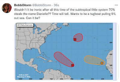
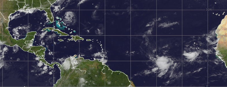
20/20 chances in the 5 day.
This odd run was earlier.
Now it's just one big wave developing.
Earlier models showed a Carib storm hitting S FL.
Now they have that storm in the GOM
Threatening Louisiana and Texas.
Next run who knows?
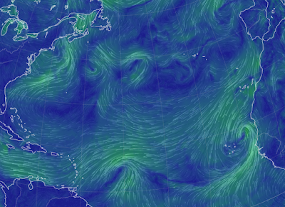
Currently the storm shows up more to the West.
Forms in the Caribbean... leans West.
Misses Miami unlike previous runs.
Makes a bee line for La/Tx line.
ON THIS RUN.
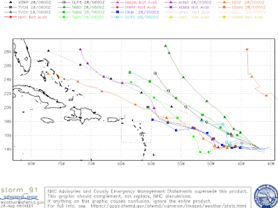
Next run?
Who knows...
Mobile?
Tampa?
Cuba/South Florida?
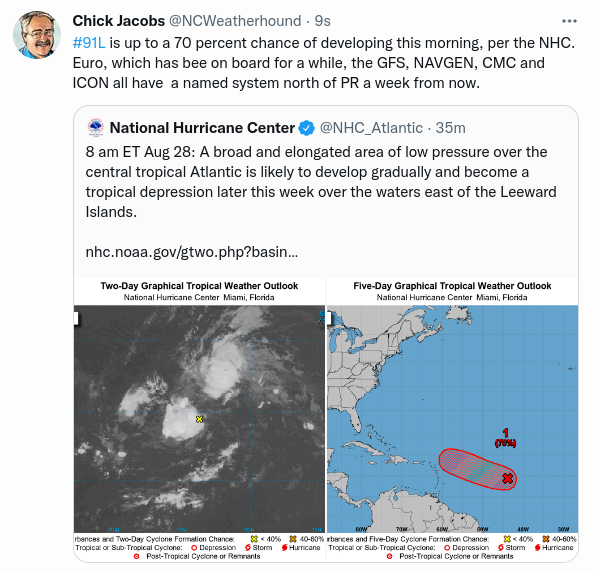
It hasn't formed.
Now is your time to prepare in case ...
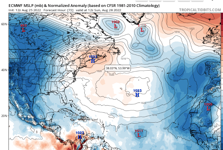
Think of the models like a 5 year old child that you ask "what would you like to do when you grow up" and the response is "doctor" or "fireman" or "policewoman" or "actor" notice how no kid ever says "accountant" "programmer" "clerk at Belks" or "manager of a bookstore" ................the same way...............everyone always thinks in a previous lifetime they were Alexander the Great or Cleopatra. LONG RANGE models are like that kid and on every model run or every other model run a hurricane will hit New Orleans, Miami or Houston if not going up the East Coast and slamming into North Carolina.
Models change often, but what you need to pay attention to is consistent long range trends on multiple models. Moisture in the Caribbean with a possible low forming or a wave staying alive with closed isobars from run to run. When the GFS drops it's main hurricane it's been showing for days and suddenly the EURO finds it and runs with it, then you know you might have a problem.
But until IT forms, it is just a model making guesses on each run. Weak waves go further West that's just the way it works. An Upper Level Low can either rip it apart or enhance it so watch Upper Level Lows, they are game changers. Pay attention to those you trust both regionally and otherwise but don't panic because a run 7 to 10 days away shows a hurricane might be on it's way to you, but don't ignore it either.
Hurricane Prep is the name of the game.
Having a plan is the best game plan you can have.
Have a back up plan.
a) Do we really need to evacuate...where do we go?
b) If we don't have to evacuate what do we need to do?
Have an extra month of meds and an extra inhaler for asthma always in Hurricane Season.
Today is the official 30th anniversary of Hurricane Andrew. People asked for my thoughts, knowing I went through it and have written about it over time. So the rest of the blog are my Hurricane Andrew Memories written in the way hurricanes really happen. Before the Hurricane has certain highpoints, during the Hurricane and the After the Storm goes on forever and ever it seems as it takes forever it seems to put normal back together again!
Have fun... hope you learn something that is helpful for you should a hurricane be chasing you. When people ask me "isn't it dangerous to chase storms" I tell them I don't chase Major Hurricanes I stay home and write on then blog and live on Twitter, but yes I chase storms and lower level hurricanes or have with friends over time. My kids are grown up, I remarried and live in North Carolina and our beaches are prone to an ample supply of weather to always be following. Often I am in Miami one of the popular places on the hit parade of landfalling storms and hype during Hurricane Season.
Again it's always best to chase a hurricane carefully than to have a hurricane chase you to your own home where your family lives.
What can be said that hasn't been said about Hurricane Andrew. Highlights dance through my mind of Hurricane Andrew.
Before the Storm:
Everything switched immediately as Andrew changed directions and intensified rapidly. I do the Jewish Sabbath thing so we had the news off until after sunset on Saturday. On Friday afternoon all the channels were "SURE" it wasn't a Miami storm due to some weak. Often I'd leave a weather radio on quietly somewhere that would run until the battery died, but they were "sure" it wasn't a Miami storm and again had out of town company. The Cold Front that looked to grab it away. Bryan Norcross opened up the possibility at his 6 PM broadcast that the new Aviation model showed a different possibility. House filled with guests, I took a break and went to a friend late in the day to talk, have some tea and as I walked back just after sunset I turned left on 34th Street and Prairie and felt the strong, steady rush of ocean air coming in from the East on that street and I knew in my gut the forecast had changed. The wind was a bit strong earlier, tho a strong breeze from the ocean on Miami Beach is not that rare, but just a few hours later it as blowing as if steady as if someone had turned up the setting on the fan to full strength. Pretty much ran the rest of the way down the block got into the house just as "Shabbos" was over and yelled "turn on TWC" and the rest is pretty much history. The phone rang ... obviously my best friend hurricane partner in crime called telling me she was right it didn't catch the "stupid front" as she was prone to calling it. My father-in-law found a plane ticket out of town and grabbed it fast and left.
We went shopping and when I say "shopping" I mean it was more a "grab anything that's left to grab that's not perishable" with every friend you had that also just found out Andrew was going to be a Major Hurricane aiming straight for the Magic City of Miami. People parked their older kids or their spouse in lines that wrapped around the store, the noise within the store with everyone running about talking loudly was similar to the roar of a hurricane coming at you fast. No diapers, few paper products and even less canned tuna or peanut butter; most non-perishables had been grabbed by the first Andrew shoppers who saw the forecast change in real time Saturday morning. Yes, I had stuff squirred away but I also had a lot of kids (nine to be exact and one a 6 month old baby) and there is only so much you can squirrel away and hide from the older kids who would find hurricane supplies as if they were on search and destroy missions for the Army.
Ran home with groceries, went to a Walgreens that mostly catered to tourists looking for snacks or medication to go with the booze they bought next door at the liquor store and grabbed the last of the diapers and baby wipes (buy lots of baby wipes) and went on automatic boarding up the house, figuring out what to do and trust me there's lots of figuring before a Hurricane.
Sharon, my best friend, of course had her friends from Crown Heights Brooklyn staying at her house and needed a radio as her battery operated radio died at an inopportune time (her 9 kids probably broke it but I digress) and so I gave her my spare Pepsi Cola Radio from the Pepsi Cola Plant in Miami that used to sell souveniers and a whole bunch of batteries. Then Sharon and I ran to the ocean, driving past tourists and other people who live on Miami Beach working the hotels walking with their many belongings from Collins Avenue, over the bridge that crosses Indian Creek on their way to the Park N Ride buses that would take them in theory to safety. My five year old Miriam was with us as we walked against the strong steady wind onto the boardwalk and stood there looking at the ocean whipping up crazy, gray foamy waves to heights rarely seen on Miami Beachs. Sea foam, not something used to vacationing in Miami, was blowing across the beach. My daughter pretended to be a plane with her arms out wide running in circles. Sharon and I talked, watched, thought in unison over what the next few hours would bring. Got home, gave her more batteries and wished her well. The neighbors who lived across the street on their way to Miami Shores across the Bay screamed out we should get up high, higher than the storm surge might be. Sweet people, yes I knew that, they had gone through Hugo before moving to Miami so they had their own nightmares dancing in their head.
I sat there remembering the terrified look on a new news anchor to Miami trying to give information on Andrew as they played the loop over and over with it lunging towards Miami and wondered if she was okay and if she'd stay in Miami very long after Andrew. Before and after Hurricanes is when you find out who wants to stay and continue to take their chances in a tropical paradise. Many leave not wanting to face such scary times as when everything suddenly changes and a weak Tropical Storm intensifies to a Major Hurricane in less than 2 days and takes aim straight at you.
The Storm:
Had a shelered "sitting area" upstairs near the main hurricane and set the area up with pillows, sheets, food, snacks and a First Aid kit and oh yes everyone had a water bottle. Fell asleep for a little bit and my best friend from LA days called and woke us asking "are you really having a Hurricane?" and after noticing the wind had intensifiied much over that hour cat nap and I said "yes, we are ... gotta go, love you" and hung up as I woke up various kids and yelled at them to get into the Hallway where our "bunker" was in the old, beautiful, well built home that survived many a hurricane including the 1926 Hurricane. We know this because the plans for the house that we needed for renovations had been lost in the 1926 storm when parts of the Miami Beach City Hall blew away with the plans. Yes, you do end up yelling a lot before a hurricane, some kids take it uber serious and others as if "whatever" and you're mentally in slow motion shock. I remember on the ABC affiliate Channel 10 the news anchor asked the head of the NHC several questions asking about trofs and whether it could stall and he just kept responding, "no it's coming, it's not going to turn away" and he was right. You wonder on a lot and remember in real time while waiting for the hurricane to show it's face officially and eventually it did.
The wind roared while the wooden floors vibrated some with the pitch and intensity of the stronger gusts. We made one last try to get my son Levi who insisted on sleeping in the bedroom on the floor into our "shelter" and as his sisters argued dragging him half asleep into the sitting room area he banged his head on the door stop waking up to "what the ... leave me alone" but no we were all going to hunker down together, that was the plan. He was grumpy but in the "shelter" rather than the East facing upstairs bedrooms. My husband kept going to the window in the adjacent bedroom staring at the amazing light show the exploding transformers were making until suddenly a loud explosion happened and our power went out and then we sat there, listening to Bryan Norcross as the power was out and the cable was also gone with the wind and Cantore broadcasting on air at TWC was a distant memory.
A few strong squalls hit the house, you could feel the wind create a buffeting sort of feel to the wood and the howl of a hurricane's wind is something mighty you have to behold to know what it is really like. You can listen to videos, watch iCyclone videos with the wind howling and the palms swaying but to be in it is wild. Surreal in ways yet so real and compelling, every moment is compelling and while similar but different. Sometimes you hear things flying in the wind, banging against the house or the house next door or your car parked downstairs and during the strongest parts of the storm you can hear the angry, surf three or four blocks away on the other side of Indian Creek. At some people some people fell asleep and others just sit there staring a bit catatonically breathing in tune to the ferocious wind howling, moaning up and down in intensity. It was at that moment in time, some of my kids fell in love with hurricanes and others did not.
After the Storm:
We were sure there would be broken windows downstairs and water everywhere, yet the house was dry and no windows were broken though the wood put up on the 2nd story windows was gone, taken with the wind. Yes, it looked like a Hurricane hit but we also knew we were spared the brunt of the fast moving, fairly dry storm.
We checked on neighbors who stayed home, neighbors checked on us. One drove slowly by checking on us, waving on his way to check on the Temple nearby that was a small well built house high up off the ground and fine. We had like five phone lines (don't ask) and the Fax Line somehow remained working so everyone for a few blocks who was home used that phone to call relatives and tell them they were alive.
We drove over to my parent's house a block away (they were in North Miami Beach crowded into my brother's one bedroom apartment along with my sister-in-law's parents, some cats and dogs) and the house was "fine" but messy, covered with debris that blew off businesses on nearby Arthur Godfrey Road and well just debris from everywhere. The backyard was filled with debris blown there by the violent wind; the a large Avocado tree next door fell over and took the backyard brick grill and picnic area with it. A tangled mess of debris and uprooted old trees everywhere. We drove up to 71st Street to check on the Temple where I ran the office and while it was fine with just the awnings blown off and some rain got into some cracks in the windows the ride up VERY SLOWLY with power out and police everywhere was informative. AC unites on top of 10 story Condos were dropped onto the road below, sand covered parts of Collins Avenue (as always) and any big Ficus Tree along the way had been uprooted along with many other trees. We had a video camera and took some video, I took some pictures. Andrew was gone as fast as it came, a fast mover sparing us a slow tedious march across South Florida and dropping relatively very little rain. Along the Bay in Coconut Grove small craft had been lifted with the storm surge and boats of all kinds were left sitting on dry land when the waters receded.

Link to this site below with many great images.
The truth is the AFTER THE STORM NEVER ENDS or it just seems that way. The power is out. The city is trashed, some parts way more trashed than others but even those who were spared the full brunt of the eye have to find someone, somewhere to cut away the huge ficus tree that landed on their house blocking their front door or back door, or both doors allowing them access in and out by climbing through a window. Ficus tree as in the big huge trees with ropes hanging down that you see in Tarzan movies, Ficus, Straggler Figs or Banyans Someone's roof was in my friend's pool on Miami Beach a block away, the neighbors were out of town and in shock when they heard their roof took flight in the wind though probably not as shocked as my friend's kids who woke up to a messy pool, yard and no power. The water was not usable, we were advised on NOT USING THE WATER so we drank the water we had stocked up BEFORE THE STORM and waited for it to rain in the afternoon so everyone could run outside and take a shower provided by Mother Nature. The power was out for way more than a week... maybe two, the water was usable several days later, but debris was everywhere for weeks, way more than a month. Debris piled 6 to 10 feet high out on everyone's swail baking in the hot humid days of late August and asthma and allergy problems went through the roof if you had a roof left. My neighborhood didn't have traffic lights up again, real ones, for months after Andrew. Eventually the grocery stores opened up and eventually they had food stocked again.
Miami Beach was "closed" and had a curfew and you could only come and go showing the police at the barracades your ID. At night they drove around with a loud horn that plaed a message letting us know "the Beach was closed" meaning where people live not the suntanning ocean beach and we were to stay indoors or out on the porch talking to neighbors. A neighor who worked for AP got back in his jeep from Homestead where he stayed for the storm and was in shock there was so much debris on Miami Beach, he said it was lucky for the tourism that every reporter in the world was down in Homestead and to be fair Miami Beach government offices went into overdrive cleaning up the debris from the main streets as soon as possible so there's be less cancelations on hotel conventions later on in 1992 and 1993.
After the storm takes a long time to get past. The hurricane can roar through in six hours if it's kind or twelves hours if it's not and many a hurricane has stalled offshore and delivered nonstop squalls for three days creating flooding and downed powerlines. Every storm is different. My family has lived in the Floria area since the 1880s moving about from Key West to Tampa to Miami with tobacco farms in Quincy Florida, every family member at some time in whatever generation has lived through hurricanes they are part of the landscape like the pinen trees and the mangroves and the colorful trees that bloom all throughout the year. Some pack up and leave, others stay and take life day by day knowing that one day they will eventually have to face another real hurricane. Real hurricane vs a glancing blow or an annoying Tropical Storm that causes flooding and media madness. The real hurricanes are the deal breakers real estate wise and determine whether newcomers sell fast and try their luck somewhere else or they figure they are now real natives after being through a real hurricane.
Nothing new here, in 1926 after the Great Miami Hurricane (head on collision with Miami Beach and downtown Miami) all the new electric wires and lights were down and FPL had signs on their trucks offering jobs to anyone who hopped on the truck and wanted a job with FPL and many a family that worked for years for FPL started out that way. Trains came South after the 1926 hurricane bringing coffins with them for Red Cross for the dead bodies, the trains took any passengers wanting out of Miami back North with them. Supposedly there were lines at the Train station for flappers and binder boys who once flipped deeds for real estate during the boom waiting to get out of Miami, a paradise temporarily gone wreck and ruin.
But Miami shines on, stronger always, shinier, prettier with tall new glitzy buildings filled with hurricane proof windows meant to withstand a Cat 5 Hurricane. Time will tell on those windows but my money is always on Miami because Miami rebounds always in new exciting ways. The views are always beautiful!