ICON Showing Possibilities. EURO Showing Something. GFS 18Z Is Like Panic At the Disco. Sooner or Later Something Will Develop...
There's a disconnect here between what you see...
...and what is being watched.
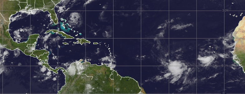
There's a weak system in the Carib 20%
There's a system off Africa 30%
There's a blob stealing the show... 0%
All that glitters isn't gold I suppose!

Nothing much has changed. I'm on "vacation" in Miami and jumping on and off to look at loops, models and discussion yet nothing really has changed. Maybe a third area gets added to the mix and there's a larger tropical buffet. In ANY OTHER year I'd be screaming "any day now!!!" yet this is 2022 and there's not even an Invest (any hour or day now) and models continue to promise distant development and then delay the development another day or two endlessly. Every year is different, I've always said that, my long time readers know I always make the joke about Cabbage Patch Dolls each different and unique. 2022 Hurricane Season definitely on the unique side.
Models show distant development, both the ICON (praised of late for sniffing out development) and the King EURO both show a wave develops in the Atlantic. The GFS always ready to party shows several Lows, possible storms and a "oh my gosh hurricane" in the same ocean.

ICON shows 2 closed Lows.
Storms forming.
A huge high in place.

EURO shows 1 closed Low.
Storm development.
A HUGE High in place.

THE GFS is offering Panic at the Disco.
If you prune it back you can say...
...maybe 2 systems to worry on.
Or just wait for the next run.
Hasn't been the most reliable model this year.
It's logical to believe that something, somewhere will form and it will move slowly across the Atlantic towards the East Coast. Then depending on the location of a front it will either be a landfalling threat or curve out to sea with a front. People from Miami to OBX will be watching carefully if anything forms. As for the Carib threat, if waves can't develop in the Atlantic but stay together enough it's likely one will get into the Caribbean and become a force to reckon with and I can almost promise sometime over the next 6 weeks that will be a problem. Eventually that's likely to happen but will it happen the way the GFS promises every other run? Probably not, but it is sniffing out a pattern that could happen. Take it with way too much salt to make any meal palatable....

I went to the beach this morning around 6 AM and my younger kids and I watched the sky change colors from Twilight to Dusk to Daylight, it was awesome. Last night we hung out in Downtown Miami and walked around the Design District for hours snacking, talking and walking. At "home" in Miami touching base and trying to do as much as possible, while hanging out and having fun. I'm watching the tropics and following the discussion but really there isn't anything to talk about until something forms. And, as always as I say where that forms and what sort of system it is (stacked vertically or a blobby mess) will make all the difference.
I'll update when I can if there is something new, otherwise have the best weekend and enjoy what you have while you got it and do what makes you happy!
Besos BobbiStorm
@bobbistorm on Twitter and Instagram
Ps... enjoy the song, next time you watch the 18Z GFS remember it's not a promise just a suggestion or merely tropical dreams. At some point, the GFS will be on the money but til then just keep window shopping!
posted by BobbiStorm @ 8:50 AM
![]()


0 Comments:
Post a Comment
<< Home