UPDATED - Potential Cyclone #4 - Forecast to be Danielle. Definitely Swimming in the Water with some Spin. MDR Quiet. Why?? Some Thoughts on That! Long Hot Summer is the Mean Season in the Wings? Watching, Waiting.

Official cone from the NHC!

Discussion shows it becoming Danielle by 24 Hours.
Sooner if they find a closed circulation.
It already has the wind speed....

So that's pretty much that. The small circulation spun up fast over warm water and the only question remains how far North the center will come in and where the heavy rains will fall! Worth saying also that long range models are flirting with real tropical potential and this could be the start of several named storms. IF the models are correct.

Nice pic and graphics from Force Thirteen
That's it since 6 PM.
Keep reading if you didn't do so earlier!
* * *

70% Red at 2 PM
Looks as if it's getting either TD status or the D name!

Water Vapor shows strong convection.
Is that the center?
Did the center jump?

Recon on the way so we will know soon!
In other areas of the world that meteorologists are watching, studying, scanning for any sign of possible life the models have weighed on long term in a strong wave moving off of Africa developing. When I say the models basically I mean the EURO woke up and woke up all the mets here. The NHC and other official sources all swear they use all the models but we all know when the EURO shows something might happen it's like a bunch of reporters just found out there was a bank robbery that happened during a 5 alarm fire and suddenly everyone's on it.

Recent wave... above. Next wave below.

Stay tuned there's some tropical drama going on.
And can't currently get into Tropical Tidbits loops.
Shame love his floaters and WV Loop.
Loop for the GOM 99L possibly upgraded to Danielle or at least TD status if Recon can find a closed off circulation.
https://www.star.nesdis.noaa.gov/GOES/sector_band.php?sat=G16§or=gm&band=DayCloudPhase&length=24

Won't lie, that's beautiful!
* * * * check back later * * *

Our Yucatan system is now over water.
A lack of convection but it's prone to finding it.
Tends to wax and wane, explode and fade.
Let's see what it can do now over water.

Need to maginify on Earthnull to find it!

As for the Atlantic...
... not much expected.
Being honest.
Being honest.
Surprises do happen sometimes.
But more so homegrown pops up fast!

A very flat view of the main development region.
I tweeted on this often last night.
I was in a mood.

If you are wondering where the storms are....
...they are way up in the North Atlantic.
Wild gales with tornadoes hitting Great Britain.
Is Great Britain still "great" need to figure that out.
Off Spain there are loops and swirls.
A horrible heat wave there.
That moves down into the Eastern Atlantic...
...kind of filters down if you know what I mean.

The undulations of the NE Atlantic....
...press down upon the East Atlantic.
This is not from SAL.
It's from the DRY HOT air in Spain...
... diving into the ITCZ
Crashes and burns.
Flattens the ITCZ totally.
SAL was July's problem
SAL was July's problem
This is August's problem.
Will the ITCZ produce in September?
If not...why not?
Either way we watch.

No one wants to say the season is over, especially when it's possible in a week or so something changes and it explodes in various places. The Tropics is that sort of place in September, and it builds in August in unrelenting waves of hot humid air lanquishing tormenting those who dislike hot heavy air and inspiring those who love the heat and the intensity. It's like one long, atmospheric run on sentence every time you open the door and think on leaving the air conditioning! Josh spoke about this on Facebook in the image up above, iCyclone he taps into the sensual spirit of the Tropics in August while watching huge thunderstorms form and hang out over the water and that scene is typical whether you are in Bay St. Louis or Tampa. It's real, it's surreal and visceral and it makes some feel crazy, hot under the collar and nervous as to what will break the long hot spell of nothingness in the tropics. 1992 was that sort of year in Miami, yet 1992 was an El Nino year and this is not, but it feels eerily the same to many old timers. The anniversary of Camille has passed and we still do not have anything spinning in the Atlantic Basin. 1969 was an El Nino year with a busy, late hurricane season with a bevy of no neck meager Invests and a late October hurricane after Camille did her nasty deed.
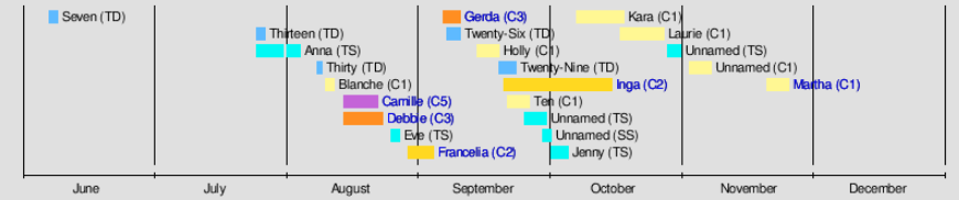
Camille is a small purple blip seen above.
Most of the season was "meh" storms.
Most of the season was "meh" storms.
Lots of TDs much like 2013.
But when one formed... oh my goodness!
Every week NOAA changes this forecast.
Every week it pushes back the busy another week.
The red candystripe area is pushed off another week.

What will 2022 end up being like?
Stick around.
Mean Season isn't for weak necked faint of heart types!
Stay cool, stay prepared.
Have a good weekend.
Who knows what Labor Day will bring!
Time will tell...
Sweet Tropical Dreams,
BobbiStorm
@bobbistorm on Twitter and Instagram
This looks way more California than Carolina and I've lived in both places. Easier to take off the platform Candys high heels and run down those steps to the ocean barefoot trust me. There's a tornado warning in Myrtle Beach, I'd like to be in Myrtle Beach as that's my beach if I have the time to stay over vs running down to Wrightsville or what many call Willy where surfers watch for a wave, any wave and children look for shells and parents just exhale and enjoy the fresh air. It's definitely been a long, hot summer!
posted by BobbiStorm @ 5:59 AM
![]()


0 Comments:
Post a Comment
<< Home