Updated! 8 PM 98L in the GOM ---Low Possibilities Yellow in GOM - Fast Mover IF it Forms... Cold Fronts Change Everything, Real Cold Fronts vs Trofs

Still low chances from NHC so prob no name...
...but who knows.
98L for now.
https://www.tropicaltidbits.com/sat/satlooper.php?region=gom&product=wv_mid Excellent link to the Water Vapor Loop of the GOM. It could make "landfall" or it might linger around and rain who knows. I've even wondered if it hangs there too long if it can circle around, strange things have happened in the Gulf of Mexico when it's Mid August and cold fronts are strong and in play for a few days. So keep your alarms on if you live in the area and hopefully someone who wants rain in Texas gets some rain!
I'll be on Saturday night late and til then follow my friends and most everything you need to know is from www.spaghettimodels.com
From 8 PM

Models running on 98L ....
...as I said earlier Westbound into Texas.
Though Gulf Coast beaches will get rain.
Will it attain the name Danielle?
Stay tuned.
Depends how fast it pulls together...
...if it pulls together!!

From Zoom Earth..

They do a great job with Invests.
Cords, data, wind speed!
Watch it in real time.
Pay attn to local weather news.
Should it develop ...
Keep reading from earlier today.

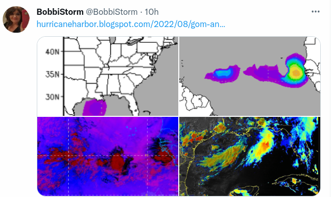
Yesterday's purple splotch I blogged on is Yellow!
NHC gives it a generous 10%
Waiting to see what it might do.
As I said last night.
2 areas to watch in tropics.
Never forget the GOM when fronts are in play.
And the water is hot.
And with a huge High in charge.
If something forms it moves West...
..slides along the coastal GOM towns.

Really watching the GOM has been fun this week, it's been like watching a Lava Lamp that meets an Etch a Sketch, seriously. But with a High near by, a huge cold front pushing down towards Georgia there's a lot going on a SPIN is easy to SPIN up QUICKLY before disapeering. Could Danielle form from that? Maybe, possible.... we will see. Link the image above in motion is below!

Different satellites show us different things.
We put them all together ....
...and we have a new, fresh yellow circle.
Basically stay tune.
We will watch the area....
...watch the next model run.
Watch in real time.
Kind of old school.
Typical I think for this old school Hurricane Season.

NAM above...
HRRR below....

Short term models we watch at times like this.
Sweet Tropical Dreams,
BobbiStorm
@bobbistorm on Twitter and Instagram
Ps... not implying it's going to Galveston.
It's going in that general direction...
..and it's a great classic song.
Check out the short blog I wrote last night......
...about just this area before purple turned to yellow!
posted by BobbiStorm @ 5:28 AM
![]()


0 Comments:
Post a Comment
<< Home