Invest 97L - Orange 40% From NHC. Models Done Poorly With African Tropical Waves........ When Will One Spin?


...some show it loses intensity.
There's alwas that one Gung Ho model too!
Does 99L follow 98L as if they are all preprogrammed. Being silly, trying to be silly and not get too intensely serious with this yet. The models have been less than stellar over the last several weeks seeing storms that never formed and tropical waves that never developed as they did in the models. I've seen many online posting models of doom and destruction in the 10 day time frame and yet the models missed the inability for that particular wave to develop even into a small closed low in the Atlantic. Why they keep missing it is a good question, though until the switch is flipped and the tropics come alive it's common for models to be consistently wrong. When I see a model I believe or a wave worth watching I will be the first here to scream "Tropical Wave, Tropical Wave!" but I don't see it yet.
I do see nice waves. Waves that may not develop, that don't become Fish Storms because they made it further West without a name and ended up close in an Invest as did 97L 98L and 99L. You see a pattern here? Camille was such a wave that didn't develop until it was deep in the Caribbean. Andrew didn't become a strong hurricane out in the Atlantic or it would have been a Fish Storm or a Carolina problem.
And, fronts are still on the map and have never stopped being on the map all season. It's a strange season I will give it that, but we will be able to discect it in the rear view mirror come December when storms are written up and the NHC does their final reports.
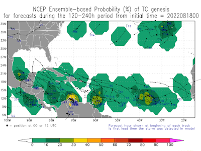
Somewhere some model is always running...
.... tossing out possibilities. Ensemble models running.
posted by BobbiStorm @ 5:32 PM
![]()


0 Comments:
Post a Comment
<< Home