UPDATED 90L African Wave Train There But...Nothing Spinning Yet. Watch Waves that Survive to Thrive Close IN... ULL with Trapped Moisture E of Bahamas.
From Zoom Earth (great site)
30% yellow.
Floater up on Tropical Tidbits!
Far out and not organized yet.
When is the big question?
I want to discuss the issue of tropical waves that don't develop fast as they roll off of Africa, yet maintain their presence until they get close in to our side of the world. Many of our strongest, worst hurricanes are waves that developed suddenly, close in before landfall. They tracked across the Atlantic, sometimes into the Caribbean and came together later rather than sooner and BOOM they exploded as they made a beeline for landfall! Not very nice of them, but that is the danger of ignoring a wave because it looks crappy or has problems spinning while it treks across the Atlantic!
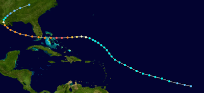
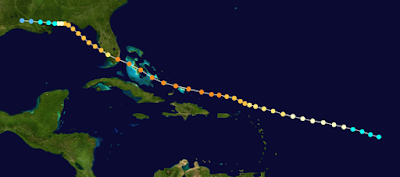
Case # 1 ANDREW
Weak as it moved WNW...
then turned WEST and exploded.
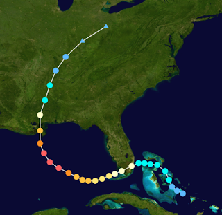
Case #2 Katrina
Weak, couldn't pull it together.
Then it did.
Then it hit the Loop Current.
Intensified close in and the rest is history.
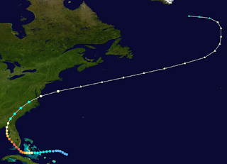
Case #3
Isn't it crazy how they can develop so fast.
Barely there in the Bahamas..
...but moving towards Florida.
Explodes and slams into the Keys.
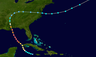
Case #4
Camille!
A tropical wave that never developed.
Limped into the Caribbean.
Developed.
Over warm waters of GOM
EXPLODED
Because we do tend to love long tracking waves that can be tracked, studied and chased eventually that keep us enthralled as they traverse the Atlantic and sometimes that happens. But, often when a storm deveops fast it also becomes a FISH storm or gives it up completely to some nasty ULL or even a rare King Tutt in the Atlantic that tears it to pieces. The 1926 Great Miami Hurricane was called a West Indies Cyclone from the West Indies that stair stepped itself up and over the islands until it slammed into Miami and kept on going.
Blue (weak) yellow (stronger)
Orange (STRONGER)
The exception here to the ones shown above.
Every season has it's unique set of circumstances. This year it's been hard to get a wave spinning despite warm water and low shear even when SAL was not an issue. So will this all change now that the MJO is in a favorable position for enhanced tropical development in the Atllantic Basin? Or will more excuses rear their ugly head or will a tropical wave suddenly develop fast into a historic hurricane?
Time will tell......... but for now we have Invest 90L and that means regular model runs and a floater to watch it's every move from far away waiting to see what 90L has that other waves before it did not have. Unless of course it fades away and the next wave does the job, if something close in does not develop first screaming "Surprise!" at Florida or the Carolinas...
Enjoy the video I made a little while ago. While watching the African Wave that is now in the MDR (middle of the Atlantic, main development region) keep your eye on things close in as well!
***
8 AM.
African Wave 20% still.
Nothing has developed there yet.
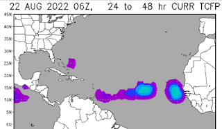
My alternative map to look at.
ITCZ lit up in blue and purple.
East of the Bahamas we see purple.
In this image above we have a huge FRONT, an Upper Level Low...aka TUTT that has captured a lot of moisture, swallowed it and running with it. Could this area close to the tail end of a front try to get something going close in? I would not rule it out. Also South of Cuba is another wave that didn't not spin in the Atlantic but didn't die and made it into the Caribbean. Always good to watch tropical waves that go far while not developing yet do not die.
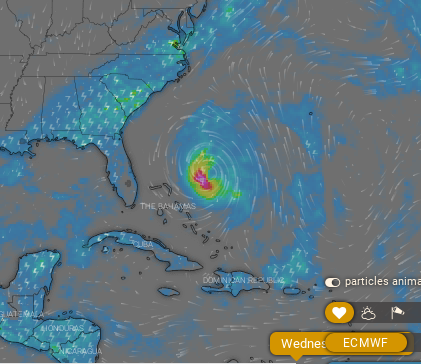
Current models show something ...
..wanting to come together close in.
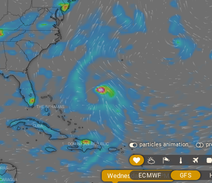
LONG TERM.
EURO above.
GFS below.
GFS sees a weaker front and weaker system.
Fronts, fronts and fronts is all I can say. I've been saying it forever. Ups the ante for weak systems that make it across the Atlantic (like Andrew) that intensify close in. Fronts scoop them up and away or fall flat and fizzle and allow them to keep going (like Andrew) or it opens the door to Caribbean Hurricanes. Leaves are beginning to turn in Raleigh, small signs consistent from tree to tree... we have strong fronts.We are more in a September set up than August and October can't be far away.
I'll update later tonight with models and thoughts.
Stay tuned.
Stay prepared!
Besos BobbiStorm
@bobbistorm on Twitter and Instgram.
Do you remember September??
I do..........






0 Comments:
Post a Comment
<< Home