Updated 2 PM -TS IDALIA Moving Out to Sea or Is IT?... to See Franklin Traveling in it's Wake........A Look Back at Idalia... What Is the Nature Coast... What's Next In the Tropics

Windy today.
Idalia to the West.
Franklin to the Right.
I want to address some speculation that is going on today regarding Idalia's final travel plans. I heard some talk online early this morning, but it wasn't supported by much. I read a beautiful tribute written by Bastardi to his father a meteorologist on the track of a storm that moved off the coast, hung out a bit and then moved towards New England... a real looper! I actually showed this storm and that season as one of many examples of strange things that happen sometimes after Arlene went SW towards Cuba from actually the near the spot that Idalia was making landfall and everyone was saying storms never do that and ... yes they do. They sometimes go the "wrong way" and they sometimes make odd loops as if they are tracing patterns in the Atlantic before going out to sea eventually. Doria in 1967 was that storm. Again 1967 was 2 years after Huricane Betsy looped twice and turned SW and hit the Florida Keys instead of Jacksonville, Florida. Strange things do happen.
What looks like scribble scrabble near the coast.
Was Doria a strange storm.
Doria was an early September storm.
See it's not just 2023 that's strange.
Point is I use a wide array of meteorologists to compare what I'm thinking against what I see on the models. NHC has incredible Mets and their discussion is always a good read. Mark Sudduth is a born teacher who can explain weather like few can in a calm, logical but interesting way. Joe Bastardi is an incredible Weather Historian more than just a Met, as that's his speciality in that he can pick a snow storm out of the late 1800s and compare it to one in the early 1900s to the one that might happen in any given year. You learn a lot about Weather History from him and he waxed poetic today about his father who he idolizes and wishes he could talk to today. He mentioned Doria as a possible analog to Idalia if Idalia does the loop! Levi Cowan is slow, methodical, analytical and calmly explains what is happening in the tropics; he is very left brain while my right brain is always fighting with my left brain. Lastly I'll add NO ONE does tropical weather better or explains it in real time like Bryan Norcross who never dumbs down weather to his audience and I respect that about him beyond the ability to even describe how much I respect him.
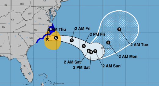
So yes I saw some models and I heard discussion, but I like to see more than one model or a few Tweets before mentioning it in the blog. Sometimes I allude to things but models have been constantly shifing around on what they expect Idalia to do. Last week Idalia was dipping down to the SE then the SW going to Florida again. The current NHC cone shows it going out to sea.
The big question is...............does it stay out at sea? Does it decide to dip down enough into the warmer tropics to reintensify, aim for Bermuda and then get blocked by a High Pressure Ridge as Franklin leaves it behind in the warm waters of the Atlantic. And, if a system approaches at the right angle (orientation learned from ContentWx aka Cranky) then sometimes a storm can be pulled back towards the Mid Atlantic or the NE coast. That's what some thought might happen with the hurricane that was out in this same area around 911, and many say had it done that perhaps it might have changed history but that's alternative history now as few actually do.
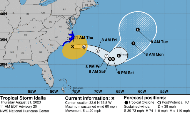
The 11 AM Cone.
Shows Idalia dipping down (not going to FL)
then...dipping back up.
At the end of the cone there's a hint..
..a suggestion it could pull more to the left.
2023 has been a year.
IF Idalia hits Bermuda...
..it'll have hit almost everything it could.

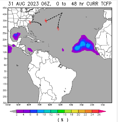
GFS shows a traffic jam in the Atlantic
When you get too many systems together..
...strange things happen.
Idalia being most West... gets cut off.
If you remember I mentioned that there was a small High Pressure area behind Franklin keeping Idalia from racing off after Franklin, outflow and the high kept Idalia moving North vs NE or ENE as many insisted would happen and South Florida could get Idalia which was dismissed as it wasn't happening.
Idalia moves towards NE... then slowly moves up towards Nova Scotia which the GFS likes to hit.

This is a good image from the ICON
via Tropical Tidbits

Shows the High between Idalia and Franklin well.
You'd think a big storm could bust thru the High.
But maybe not.

The Icon shows it's movement away from NE
No Landfall but maybe some impacts.
Surf... winds... ???
Oh look there's a storm NE of the Islands.
Pay attention it's September there.
KING EURO
Note this is way down the road.
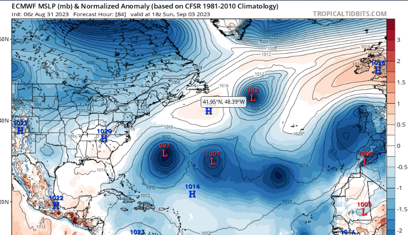
High says NO GO Idalia.
Takes the other riff raff storms.
Some models suggest those two storms dance.
Speculation still.
The NHC Wind Map is below.
11 AM Forecast for Idalia
In the SHORT TERM.
IDALIA is Moving out to sea
After Franklin
In it's wake.
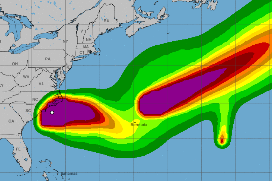
But it is possible things get wonky.
Wonky has been big in 2023.
But again it's been big in 1967 with Doria.
Wonky and loopy is not unprecedented.
Ginger in 1971 was the Queen of Loopers.
That said please read my thoughts on Idalia below.
Why did I think today would be an easy blog?
It's all good... low death toll from Idalia.
That's very, very good.
Lighter winds than expected.
Blog explains why below.
Today Idalia has gone away, Eastbound.
Maybe it'll come back.
Maybe it'll loop.
Still in the realm of Maybe.
Compare and contrast with 8 pm below
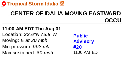
Idalia Advisory at 8 AM.
Strong Tropical Storm still..
Back to the Basics.
Idalia has moved offshore.
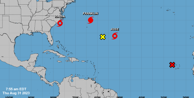
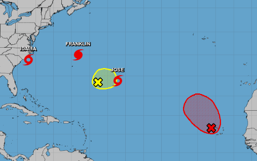
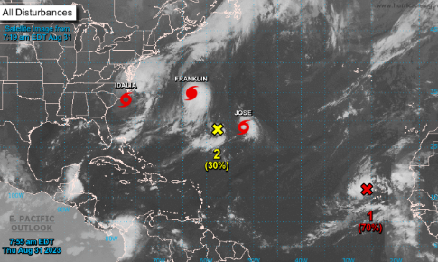
Jose was named in the ATL
New strong wave with 70% red X...
...should be Katia soon!
Obviously they are E ATL storms.
Mid North ATL storms.
NHC Satellite imagery shows us the players.

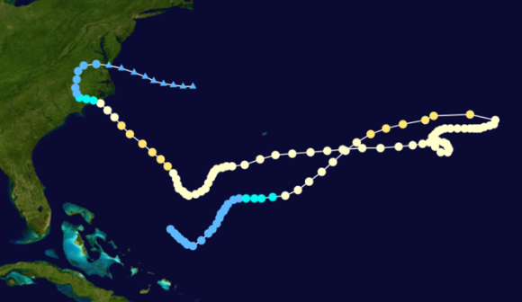
Franklin out in the Atlantic acting as if it's a new semi-permanent spot on Planet Eart. A weakened Idalia is off the Carolinas.You can see the long tail it got back, that formed that mirrors models that showed it turning back around towards Florida, there is moisture/rain there but the center of Idalia is not looping back for another chance at landfall in Florida. Sometimes models pick up moisture that is there, and show something but it often gets lost in the translation. Jose is obviously a 40 mph minimal storm moving up to the NATL influenced by Franklin that will slowly move away into the Atlantic; no need for a cone there.
New wave off Africa is promising.
GOM could produce "something"
Or not...
Watching carefully anything in SW Carib.
As we know which way it'll go.
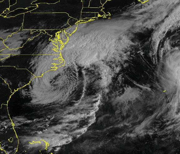
There's Idalia and a bit of Franklin to the East.
Impressive signature, still has a "center"
Long tail that looks like the old models.
Could the tail snap off and develop?
People have asked...
... yes, no ..not really.
This is the Cone.
Nuff Said.
Let's move on.
Keeping this basic this morning. We are all exhausted from information overload. A collage of images bouncing around in my head like when Google or Apple send you "photos from August" and asks if you want to pay for a little book they will send you. I've done it, not doing it with Idalia I can tell you that much.
I have a lot of questions about Idalia and I have spoken to friends chasing. I've looked at the damage close to landfall and I have questions. When you see a trailer park where the signs are down after the storm passed, a bit of roofing torn off you really have to wonder as usually a Major Hurricane would take the trailer not the sign. I saw some man on Keaton Beach complaining about all the fuss and how they don't usually get storms there and all his signs were still standing advertising products and I'm thinking this makes no sense. I'm not saying it was not strong at landfall, more so an odd wind pattern and that happens sometimes as no two hurricanes are the same. Friends chasing said it had some of the strongest "gusts" they had seen, mesovortexes within the eye, random wild blasts vs steady strong wind but crazy gusts. Again, Idalia had a very small tight eye, that can be deceptive as the area of Tropical Storm winds were huge and the area of intense Major Hurricane winds were small and narrow. If those winds hit you, you'd know it was a Major and yet not far from the small tight eye it didn't look that bad. We saw this actually with Ian also and you noticed it if you watched coverage on TV. Pines snap easily, oaks rarely snap unless they are not well though they do lose limbs and one huge Oak branch crashed across a highway or into a small home can kill and often does. The lack of high wind reports has been attributed to eye wall replacement cycle as it was making landfall (it ran out of time to finish that cycle) and dry air entrapment lowering the intensity of the winds. You can see below the radar that shows the mean Western side overland intact het the SE part of Idalia where it made landfall shows much less weather, lower winds and less storms.

According to Google Idalia killed at least 3 people and they say at least as we are still going through the recovery phase but thankfully it was low. I'm sure the memory of recent Ian in a nearby area pushed people to be more careful than they might have otherwise. 2 people died in car accidents before the storm and a 3rd man died trying to take apart a downed tree. Often people are prone to dying before and after the hurricane, unless you are living in a shack out by the water you an usually hunker down and hide from the wind or run from the water, but people rushing about nervous make mistakes and after the hurricane people literally die trying to take debris off the house, the roof and well people are tired, nervous and accidents happen.
The storm surge showed up at Cedar Key and was as impressive as expected and it'll be a long clean up for water damaged places that may have withstood the surge but will not be liveable for a long time. Mold sets in fast in Florida, within days it's everywhere and you don't see it the day after. It takes a long time to fix everything up after that sort of storm surge.
And, yes it was a kinder path than other hurricanes that hit large metropolitan areas, and yet for the people who lived in the small towns in it's track it'll be as memorable as it was historic in that we have little record of huge hurricanes that have hit the Nature Coast and the lack of strong development in those areas shows that it was not considered a good place to build a town; beautiful, low lying marsh and with every strong storm the coastal area flooded and anyone who tried to set up shop there, moved inland somewhere or to another place.That's how civilization begins in a new land where immigrants from Europe are settling and are taken aback, shocked by monsterous storms that roll up from the tropics. Put yourself in their shoes.. in their head. One day the weather has been beautiful, the crops look good, they are adding onto their little homestead and the next day there's a beautiful steady breeze coming in and the next day they are lucky to survive a storm they have no way of even explaining in letters home to family in England or Greece. As a child when I heard about the Lost Colony it was shortly after we missed school for a week after a hurricane and I thought "um duh it was a hurricane, bit storm surge washed over it... what's the mystery here?" and though I may be wrong it shows you how a Miami kid thinks when they hear an early pioneer settlement was gone with the wind.
I'll note that old timers in Miami often attribute surviving sudden "West Indies Cyclones" as they were called then to Seminoles who they were friends with and traded with often, coming into town and letting them know that a "Big Blow" was coming and to prepare. I know this from old timers, family members not just history books telling colorful stories. Many old timers showed gratitude and talked on how they came to trust their Indigenious friends who knew the land way better than them.
As for Roanoke and the Lost Colony...who knows it was lost.......

I do know we got very lucky, as bad as it was, we got very lucky. Tallahassee did not get very lucky and I warned people who lived there that they would get stronger impacts than they might think as the back side (West) side of Idalia may deliver stronger winds and hoped I was wrong. I was not wrong. I wish I was but when a strong hurricane meets a diving cold front the boundary between the two gets strong winds, stronger than if it wasa hurricane wandering around at the edge of the High looking for a place to make landfall. And, as I said they move very quickly, quicker than normal as it did in Georgia and the Carolinas.

Cedar Key is that little Island offshore.
And everything behind it is low country, marsh.
A nature reserve, that's why it's called the Nature Coast.
Going out you can see Google Earth.
Note all the "civilization" is further inland.
All the green is marsh, low country.
Kind of like the Everglades but a bit different.
Note how far Tallahassee is INLAND.
Gainesville is far inland.
Steinhatchee and Perry the main cities.
And, they are cute small towns.
Very similar habitat to lower Louisiana.
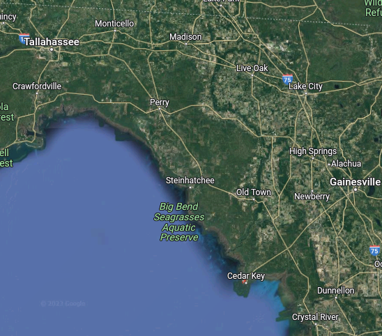
Big Bend above.
Louisiana below.
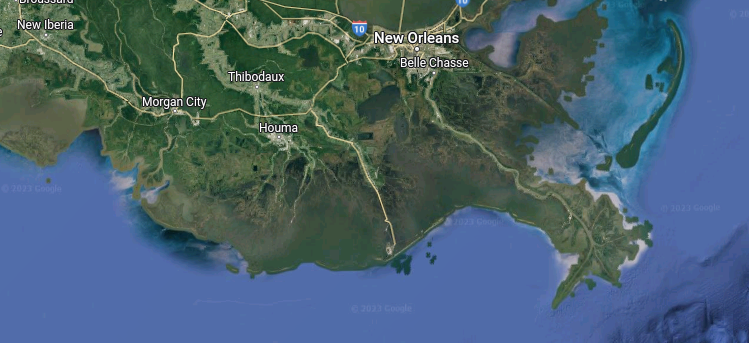
See what I mean?
Beautiful low country, marsh.
Some would say swamps...
..swamps really different.
From Google.
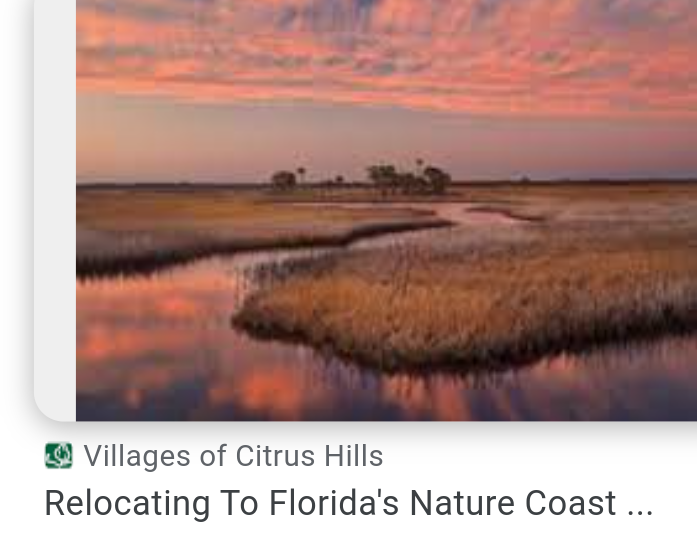
Beautiful, but very low country.
With pockets of oaks, trees, hammocks.
Floods easy.
And, that's it. That's all I got to say today. Today is a day to enjoy the incredible cool breeze coming through my open window. To take a walk around the neighborhood. To get my life in order, catch up on everything I've ignored for the last few days. I feel almost bad enjoying this so much, as many will not remember Idalia so kindly. But, I'll remember sitting out on the balcony with a cup of tea, watching the rain fall being in awe how systems that come from so far South down in the Caribbean and form in the Gulf of Mexico once North of Cuba and travel far to end up sliding out into the Atlantic in North Carolina leaving farms some beneficial rain. And, last night it rained on me while I was out an about, raindrops with DNA from the Tropics and Idalia.
Tropical Meteorology is amazing.
Geography is awesome.
NHC is good.
Back in the day the early settlers didn't have any NHC Cone to complain about when it is off by 20 or 50 miles at landfall 48 hours earlier, or when the wind intensity collapses on one side and it's more wicked than expected on the other. There's a reason we say "PREPARE FOR THE WORST, HOPE FOR THE BEST" and it was repeated often by the NHC and every met I know that IMPACTS MAY BE FAR FROM THE CONE with Idalia.
If you missed the high storm surge ...give thanks.
If you missed high hurricane winds... give thanks.
If you missed tornadoes...........give thanks.
Gratitude should be the attitude today!
If you got lucky.
Sweet Tropical Dreams,
BobbiStorm
@bobbistorm on Twitter and Instagram... Threads when I remember to go there.

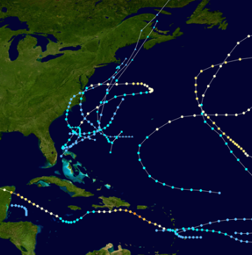
September Tracks.
But since it's 2023...
... just pay attn!!
The song today is dedicated to Idalia who is off to see the Wizard Franklin and hopefully they both take off finally. But, tomorrow is September, September is the Prime Time in the Tropics so stay prepared, pay attention, be aware as trouble will bubble back up soon nuff.
posted by BobbiStorm @ 7:42 AM
1 comments
![]()


