Hurricane Harbor

A writer and a tropical muse. A funky Lubavitcher who enjoys watching the weather, hurricanes, listening to music while enjoying life with a sense of humor and trying to make sense of it all!

Sunday, August 31, 2014

Invest 99L 60% Red Alert... Will it form in BOC? And... Sneak Peak at Newest Cape Verde Wave


60% chance of developing in 5 Days ...

The Bay of Campeche is an interesting area where systems that look weak over the tip of the Yucatan often blossom into named storms just as they are making landfall. The NHC is keeping a close eye on it and upped the odds tonight to 60%.

However to the naked eye it doesn't look like much tonight. It's parked over the Yucatan and should emerge tomorrow and blossom .... Time will tell.


Models:


These are your typical tracks for this type of BOC system. As typical and boring as this can seem to many who do not live south of the border it's worth noting that this batch of tropical rain worked it's way west across the Atlantic.... into the Caribbean... and now into the Gulf of Mexico. I think that's pretty impressive. The way the world works, the way the atmosphere flows around highs, from low to lows... isobars closer and then further apart. Really awesome.

rbtop_lalo-animated.gif (720×480)

A lot going on there...keep watching...

avn-l.jpg (720×480)


This image shows where the real action is going on inside the Cape Verde Wave.

jsl-l.jpg (720×480)

Time will tell if this batch of convection manages to make it's way across the ocean all the way to the tip of the Yucatan where we will watch and debate if it might get a name. Or... it might make it's way to the Leeward Islands like a few have done so far this season... 

It's the way of the world right now... one wave after another takes it's shot and moves over hot water trying to maintain it's convection despite very dry air. 


We'll see. 

Tomorrow we'll know if this African wave can swim and if Invest 99L can get it's act going before moving west into Mexico.

Sweet Tropical Dreams, 

Besos Bobbi

Ps.. maybe if they named a hurricane CAT we might get something worth talking about. Yeah... no NFL football, no hurricanes... I watched Cat Ballou. What's a girl to do huh?


Labor Day Without ANY Hurricanes... Anniversary of 1886 Charleston 7.3 Earthquake... & Hurricane..


Only tropical game in town with a real chance of winning a name according to the odds makers at the NHC. 


Some people...........are watching the Cape Verde Wave that is coming off of Africa... 
I'm trying not to be sucked in here and using a bit of reverse psychology..

Some people are watching the radar over Praia....


Yes... I see it ... it's there........nice, pretty colorful image.

Moving on............the old wave that didn't make it is flaring up in the Central Atlantic.


Same old...same old... should be near PR soon...

Note there IS spin over the Yucatan. 
Many mets say it's "mid level" 
which means they don't like it...
others say there is some "low level" spin
which means they do like it....

I'll be back later today... tonight....
when there is something to talk about... 

Besos Bobbi

https://www.youtube.com/watch?v=BQLpRBDrhn8

Ps... a 7.3 Earthquake hit Charleston, SC in 1886 on this day in history...
while they were cleaning up from a Hurricane.

NOW......THAT'S SOMETHING TO TALK ABOUT...
http://library.sc.edu/blogs/academy/files/2011/08/After-the-Storm-8-5.5.pdf


Friday, August 29, 2014

Caribbean Convection & Labor Day Hurricane. History of the Bonus Army & the Vets Washed Out to Sea..

In the Gulf of Mexico there is a large area of convection that has been lingering around a bit too long for comfort and needs to be monitored... just in case.


Introducing Caribbean Convection Up Close and personal on the new floater.


vis_lalo-animated.gif (720×480)

Going wider we can see it in the Caribbean and the whole area that is convecting...


Seems to be moving fast...towards very warm water.

athhp.gif (873×397)


The reason I'm paying attention to this little wave in the Caribbean that has the remnants of Invest 97L in it that has been following the more southerly model paths as it ... didn't develop so it went WEST. As we all know or should know a weak wave that doesn't develop moves west into the Caribbean vs taking the path towards San Juan and the beautiful Virgin Islands. And, IF something develops in the Caribbean it has to hit land to get out of the Caribbean. Either it continues west towards Central America. If it strengthens the atmospheric currents in place will life it NW across the Yucatan into the GOM or BOC.

Currently the NHC is monitoring it in a long term fashion. A sort of wait and see what will be over the next few days.

* Formation chance through 5 days...medium...30 percent.

Okay...that's something to watch. Mind you we have watched this area before.

Earlier in the week Invest 97L was being watched and models were run.


Right now it's just "disturbed weather" and it could get more disturbed down the road. It could even become a Tropical Depression or Tropical Storm if the conditions improve.

A lot of IFS but its important to stay informed of changing conditions.

Why you ask?

Because back in 1935 we did not have weather apps or a weather radio or weather sites online.

There was a weak storm moving west towards South Florida and no one was aware of it. Labor Day was coming and people were out and about going on picnics and spending time with family. In the Florida Keys there were Veterans working in "work camps" not much better than what most Boy scouts look forward to for a nite... but for weeks, months and they would take their checks and send them home at the height of the depression.  There's a long history behind this drama.


Cliff Notes ... many vets wanted to take money from their benefits to feel their families during one of the worst depressions in History. They camped out on the lawn in DC and it became an embarrassment for the President and was covered by the press...ongoing... Vets who had risked their lives in World War 1 who wanted help from the government...they wanted jobs. So they were given jobs... hard jobs in harsh places like the Florida Keys in the summer without air conditioning. Sand flies, bugs, thunderstorms...heat stroke. Because they had already had a hurricane while building the Overseas Railroad early on they were well aware of the dangers of a hurricane and having to evacuate people from the work camps down in the Florida Keys. A plan was said to have been made and if anything happened they would send a relief train.


Cliff Notes Ending... when it rains it pours and worst case scenarios pile up.

It was Labor Day. Government officials were on vacation thus slowing down the plan from going into action. The Hurricane developed fast Andrew style from a weak storm and no model saw it coming. There was no argument between the EURO and the GFS and not even the Canadian or Aviation model were around... in fact there were no computers. Maybe a few Seminoles knew something was up from signs that were handed down generation to generation.

And... when they finally sent the train the bridge got stuck and it delayed the train at least 30 minutes, probably close to an hour or more according to Miami Historian Paul George. By the time the train got there it was too little...too late... and the train and what was left of the work camps was swept out to sea along with the families who lived in the Keys.

Sort of ironic isn't it that the hurricane's track looks a little like the train that left the tracks.

The ONLY silver lining here was that because it was Labor Day a lot of the workers took off and went into Miami to visit friends... have fun and get a break from their hard work. The many who stayed behind were the fathers who sent home money to their families... the sons and brothers who didn't spend the paycheck for a trip up into Miami for Labor Day.

Some good links:
http://hnn.us/article/16158

http://www.sun-sentinel.com/news/local/southflorida/sfl-1935-hurricane,0,5269672.story

http://collectingmythoughts.blogspot.com/2010/08/who-murdered-vets.html

In 1935 there was no orange graphic from the NHC giving a five day warning for areas that might develop into a hurricane with Las Vegas like odds. And, they do a great job!


Back then we had a train that went to sea... and when you were on board and you looked down all you could see was the sea. I've had old conchs tell me how exciting it was to take a trip on that train to Miami when they were 5 and 6 or 7.

82.jpg (1024×651)

Note that in 1905 there were environmentalists in South Florida who didn't like the environment being messed with.... and one of the best said that if you damned up Florida Bay with the long railroad tressels that it would create a damning effect and create a tidal wave during a storm surge. And, that is what happened. Yes it was a storm surge, but a storm surge made worse by the set up that had already killed people during the building of the railroad in 1905.

You can read a long blog post from the past that talks on this further.

If you think there were conspiracies after JFK was shot ..it was nothing compared to what went on after the 1935 Hurricane. Many said that by the weather bureau saying it was a Category 5 it was a fake way of absolving the government from any responsibility for the vets as it was now an "Act of God"

However...the NHC has gone over that storm many times and they do feel it was a Category 5 Hurricane and they do have the final word.

http://hurricaneharbor.blogspot.com/2012/09/1935-labor-day-hurricane-facts-myths.html

The part here that is important to remember is without satellite imagery, without the computer models, without the forecasters at the NHC interpreting the data... weather forecasters were blind sided often by hurricanes that go through Rapid Intensification and suddenly appear off shore as a Major Hurricane.

We had great maps, but the warnings came to late for the men out in the work camps on small islands connected by railroad trestles, road beds and bridges.


Weather blows up fast. 
Suddenly.
Computer models are sometimes wrong...
... like the wave that they liked... and then they didn't like by Africa...

Andrew blew up fast.

Happens.

So... never ever count out weather for the potential to surprise us especially about Labor Day.

Go to the beach.................
Have a picnic....................
Spend some money and help the economy.
Make memories... good ones... 

And, keep checking in to see what's going on in the tropics...

Besos Bobbi

If you are in FL... South Florida... 
Take a trip down the overseas highway...
Mile Marker 82

https://www.youtube.com/watch?v=8yfdZTfTcGM

And check out the Pro Bass Shops where there is a replica of the Pilar similar to the Hemingway's boat he took up the Keys after the storm passed in Key West to be one of the first reporters to see the devastation from the Labor Day Hurricane. 


Thursday, August 28, 2014

Carib Wave Only Game in Town... Ex invest Flaring Up. African Wave on Hold...


NHC puts a yellow X in the Caribbean this evening giving it low chances of 20% down the road. It also has a yellow X parked over Africa. It's been there for almost 24 hours so wondering if their site is broken or it's being stubborn and refusing to get in the water. I've had kids..sometimes they get like that ya know??

I also get this all the time on their banner. No it's not my computer, every other site is fine. So maybe it is a bit broken. Strange line on the left of the banner. Hmnn...


The yellow X in the Caribbean is the old Invest 97L that was downgraded, but seems not to have read it's press releases. It's been flaring up for the last 24 hours.. possibly even the last 36 hours. Ole John Hope insisted on things sticking around for 36 hours until he gave it any credibility. It flares up, down and back again. Then again it's been doing that since it left the coast of Africa. Something I may add the new wave seems unable to do.. 


The NHC has this cool feature this year where you click on the 5 day graphic forecast. And, suddenly it shows the tracks. Personally I think it should be below the original possibly in a smaller box as most people can't find it and are confused why some people say ZERO% and others quote the NHC as saying it has 20%. A bit confusing... 

My thoughts?


There was a show years back my father loved called "Car 54, Where Are You?" and beginning to feel this way about the much anticipated Cape Verde Wave? As we say in Miami.. "Donde?"  The Caribbean however is not an area where you have to ask where is the other area they are watching. 

Put it in motion...

wv-animated.gif (720×480)


It's oozy... it's disorganized... and it's moving West slowly in tandem (but slower) than the ULL to it's north. It's possible that the ULL will begin to tickle it and make it break out in convection rather that fits of giggles. To make that simple.. an ULL can and will often ventilate a stubborn wave and enhance convection. The ULL is what looks like a black cane moving towards the Bahamas. It's being pushed west by the tail of energy left behind by Cristobal.

The high combined with air flow around Cristobal zooming down into the Carib pushes everything west. Now note there is another system about to move East.

wv-animated.gif (720×480)

Anything that does even begin to form will move up towards the Yucatan and get picked up and pulled up... somewhere. It's just too soon to tell as the models are not screaming orgasmically about the wave. In fact the models do not want to develop it. 


 The always excitable Canadian model that gets pushed aside for the seemingly more sexy Euro Model develops the ex-Invest in the Carib and takes it towards Mexico in the GOM as a decent little system. It does less with the Cape Verde Wave surprisingly.  The reason we go to more than 2 models is because they all show us something. It shows a strong high . . .

ft-animated.gif (720×480)

I might suggest putting up a floater on this system. They have a floater up in the GOM still for the Tex/Mex Invest yet there is NRL Invest for it in addition the NHC has an X over this system in the Carib yet NO floater or NRL Invest. Hello? Am I missing something here? Yeah.. a floater...

Officially this is all they have to say graphically about it.


Currently, it's really the only game in town. Well, until the African Wave moves and is able to swim in the Dusty Atlantic.

Sort of pitiful looking wave there...

ft-l.jpg (720×480)


Something worth mentioning tonight. Several people have been killed while swimming in strong Rip Currents from Hurricane Cristobal. Three people were killed in Hispaniola from flooding.

http://www.weather.com/safety/hurricanes/hurricane-cristobal-rip-currents-east-coast-bermuda-20140827

http://www.dailymail.co.uk/news/article-2733477/Three-people-killed-Caribbean-Tropical-Storm-Cristobal-strengthens-moves-north-U-S.html

Just shows you even a storm like Cristobal can takes it's toll on the lives of the people who deal with it both up close and far away. Sad, but true and not all the figures are in yet. Slow moving large storms like Cristobal take a  larger toll than a well organized small Category 1 Hurricane sometimes. Just so much rain... so much flooding... so many teenagers who think they are strong enough swimmers not to worry on rip tide warnings. That goes for adults, tourists and well just about anyone who takes their chances when there are strong rip tides.

So... I'll be back tomorrow with more information. IF the wave in the Caribbean continues over night and maintains it's convection and or builds even stronger convection I think it's time to put up a floater and wonder if Invest 97L can come back to life?

Only time will tell...

Besos Bobbi

https://www.youtube.com/watch?v=PsKZewdhDtk


Wednesday, August 27, 2014

Invest in the Gulf of Mexico. Caribbean Water Hot! Cape Verde Wave 40% &... Cristobal.


Invest 98L forms in the Gulf of Mexico... it's an area of low pressure, convection and a semblance of a swirl being investigated for further ...formation actually. But, we in the tropical business get so excited over a new "Invest" so... putting it up here to start off with as it has more possibility for impacting land than Cristobal.

This column should be named "Lessons I learned from NHC Director Bill Read" because learned a lot from Bill in conversations at programs held at HRD in Miami.

HRD = Hurricane RESEARCH Division vs NHC National HURRICANE Center.
At HRD they work on research all year long as well as when planes go into hurricanes. At NHC they forecast where the storms will go and ...work on research as well.

It's one of those which comes first the chicken or the egg things.

Bill moved to Miami from Texas. His understanding of Gulf Systems and their inherent, compelling problems of being born so close in vs big, lumbering Cape Verde Hurricanes that Miami kids grow up watching.

I have to admit, most Miami kids stop watching a hurricanes once they make it safely past Pensacola with a sort of "oh it's going over there" mind set.  In the Atlantic they watch until they make it north of JAX because there's always this thought it could loop back like Betsy... but once bound for La/Tx they aren't doubling back to South Florida. A few odd exceptions in the GOM... but you get the idea they are gone, gone, gone.

In Miami we watch every wave westbound out only in the shipping lanes waiting for them to get to our part of the world. We watch as they move towards the islands and wonder which island will get hit. We watch as they slam into PR or move up and over PR and then we watch them move closer and closer.. And, we wait for that almost always recurve out to sea off shore. Then... sometimes... we watch everyone go crazy preparing for those one or two that make it onto the beaches of South Florida.

The wave over Africa is more than 10 days away yet people in Miami are watching it.

avn-animated.gif (1120×480)

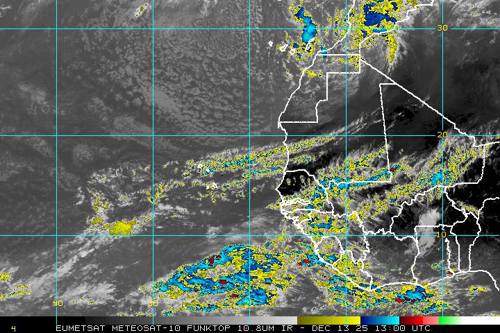
Note how fast the color blows up on this satellite loop. Nothing.. nada... BAM! Hello Invest 98L. Yes, the models were teasing a bit and we've all been peaking at it while watching Cristobal but suddenly it's there.

Way over there to the left of the screen behind the blackout area is a wave just coming off of Africa that Miami kids who are into weather are watching.  No, they aren't watching the area in the Caribbean that is blowing up today from interaction of an old wave and the monsoon trough like area near Columbia. They aren't watching Cristobal cause he is gone...gone...gone and no one is watching the GOM in South Florida.


But... for the people along the coast of Texas and Louisiana all tropical eyes are looking south at that area of convection just off shore, close in that could flare up and become a named storm.. move towards land and make landfall in a 48 hour time span. Probably not this one as if it forms it will most likely move west into Texas where they can use the rain. But... that is what often happens in the GOM when storms form just offshore. There is no 5 day lead time or 1 week...or 10 days like with Cape Verde Waves. It's in your face, 1, 2, 3... BAM before you know it. You have to stay alert. You have to have your hurricane supplies and evacuation plans in place to implement quickly.

One long coastline that stretches from Tex-Mex to Maine that can be impacted by Tropical Cyclones and yet each area has their own unique problems.

vis-animated.gif (720×480)

You can see the spin... it's there.. there should be a floater or Invest up soon. Will it get a name before it runs out of Gulf water? Time will tell.

Note that the convection is a bit misplaced in this loop, but does blow up BIG and as I said FAST. It's having problems wrapping the convection because of shear. If the shear lessens it may develop.

ft_lalo-animated.gif (720×480)

And, this is why we watch the GOM storms carefully as they change FAST in real time and IF they form..they make landfall fast!

And.................there are also other threats in the GOM...those being west bound Cape Verde Waves that come further south than most this year and that go under Cuba...up through the Yucatan Passage and target some nice GOM beach as their final destination.

Currently in the tropics we have a before image and a after.


Our HURRICANE Cristobal off the East Coast headed out to sea.. 
Amazing that Cristobal made it that far shlepping the other X still spinning on in it's wake to the S..

wv_lalo-animated.gif (720×480)

Look at that loop carefully and try to do so without scratching your head.
And note the interplay between the dry air and the moist air 
both exhilarates and keeps Cristobal in check.. 

Dry air near a Hurricane can act much like an ULL on a wave... 
blows it up a bit but in the long term keeps it from doing much more than flaring up
and down
and up
and down..

Moving on to the GOM


The Invest area is moving generally West..
it's convection is moving generally NE
The sun just rose over it... our first good morning visible.

Our Invest in the GOM has a 20% chance of developing in the short term... 

The wave that now is no longer & X but has an area of potential development in the long term is forecast to move into the Caribbean and that's interesting. A break in the pattern as the High moves a drop more to the West... splits in the Atlantic just enough to allow the new wave off of Africa a way out to the North ONLY IF IT INTENSIFIES FAST... if it is a slow developer as the EURO is hinting and the pattern suggests it will continue west bound like the ones before it.


The wave off of Africa has a 40% chance in the LONG term of developing.
The Invest in the GOM has a 20/20 chance of developing..short term long term..not vision.
The area in the Atlantic that I don't think is worth writing off for the long term has a 10% chance.

Again..curious to see how it interacts with the monsoon trough that is flaring up this morning.

Discussion on the convection in the Caribbean is buried in the Tropical Discussion:

"CONVECTIVE PRECIPITATION...SCATTERED MODERATE IN THE 
NORTHWESTERN CARIBBEAN FROM 19N TO 22N BETWEEN 78W AND 87W 
AROUND THE PERIPHERY OF THE MIDDLE TO UPPER LEVEL RIDGE OVER THE 
GULF OF MEXICO. SCATTERED STRONG ALONG THE NORTHWESTERN COAST OF 
COLOMBIA AND PANAMA NORTHWARD TO 14N BETWEEN 75W AND 79W. THIS 
CONVECTION IS BEING AIDED BY UPPER LEVEL DIFFLUENCE BETWEEN THE 
INVERTED TROUGH TO THE EAST AND ANTICYCLONIC FLOW TO THE 
NORTHWEST OF THIS PART OF THE BASIN. OTHER CONVECTION IS 
ASSOCIATED WITH TROPICAL WAVES DISCUSSED IN THE TROPICAL WAVES 
SECTION. THE 24-HOUR RAINFALL TOTAL IN INCHES FOR THE PERIOD 
ENDING AT 27/0000 UTC...ACCORDING TO THE PAN AMERICAN 
TEMPERATURE AND PRECIPITATION TABLES...MIATPTPAN/SXCA01 
KNHC...WAS 0.10 IN GUADELOUPE AND 1.79 IN TEGUCIGALPA."

Read more on this here.......... 
http://www.nhc.noaa.gov/text/refresh/MIATWDAT+shtml/271158_MIATWDAT.shtml?

Good link to keep track of any interests you may have in the Caribbean.
http://stormcarib.com/

Otherwise... keep checking in here and at Spaghettimodels.com as Mike is covering the whole tropical shebang... as always. sats, models and discussion...links, loops & xray vision down into the storms.


Went to Wrightsville Beach yesterday. Nice place.. not really my type of place as I prefer my water warmer and more colorful, but it's a beach. Surfers were out and working with the strong rip tide and waves that got better later in the day. This picture was early in the day.


There is something seriously wrong about a beach where the sand is not hot in late August.
Then again.. leaves are turning on the Maple trees up here & it's been in the 60s at night.
The color of the water is way too deep blue...dark blue.
Yet...the surfer from Seaside NJ loves it because the water is so warm down here...
(rolling eyes)

The picture was taken from the pier. The pier was rebuilt after Hurricane Hazel took it out..

http://www.johnniemercerspier-nc.com

Ended the day at a nice place where I went to the watch the sunset over one of the inlets rather than the river in Wilmington where we usually go. Chose the place as it's on the East side of the inlet facing West so in theory you could watch the sun set over the inlet. When I got there they had a shade pulled down low so that the sun wasn't in the eyes of the diners. I swear I will never understand the mindset of people in NC.. never ever.  She explained to me the diners don't like the sun in their eyes. I explained if the shade was down you can't see the ...sun set over the water. I begged her to let me sit at the far end where there was no shade allowing me to watch the sunset. After I left they had a whole discussion about the shade and raised it a bit. The diners sipping their wine not watching the water at all didn't seem to notice one way or the other.

This is what we do in Miami... we sit outside on a deck over looking the water by the setting sun to watch the sun set over the water.  

Just blows me away up here. A lot of great people, places and despite the pretty sunset I won't be rushing back any time soon. Rather watch the sunset form Morehead City or Atlantic Beach..or Myrtle Beach or Miami Beach ;) or a rooftop in Savannah setting over the river. But...it was pretty. Shame the drinks were so watered down. The food looked pretty good. Went for a drink and a chance to watch the sun go down...  Won't give the name.. because I sort of trashed the place. Okay was Bluewater.. not bad for most people, but most people are not as particular about sunset views or the water or their tropical drinks as I am... I'm a Florida girl spending time up here and at times it is beautiful. At times every where is beautiful... got to learn to enjoy small moments of nice in the overall mix of life.


Read more on Bill Read. A good man who was a  good person to take over at the time he did and he is remembered fondly.

http://www.nhc.noaa.gov/qa/201205_bill_read.php

Besos Bobbi

Ps... WHY am I OCDing on the Caribbean? Because the water is HOT if anything flares up there it has a lot to work with and can only go two ways. West into Central Amerca or North up towards Cuba and the US.

TCHP.jpg (666×375)TCHP.jpg (666×375)


Tuesday, August 26, 2014

Hurricane Cristobal. Not Pretty but a Hurricane. GOM & Atlantic Both Being Watched for potential D & E Storms..

vis_lalo-animated.gif (720×480)
For all the disbelievers....that is Hurricane Cristobal with an eye about to pop out. 
Now some may say it's dry air intrusion (not good think Chinese dry wall...) but it's a dry slot in what should be the center of Cristobal.

Now let's look at him from far away... 

wv-animated.gif (1120×480)


Looking up at the larger image you can see the dry air that Cristobal is fighting and playing off of.. 

Think one of those long term romances with an annoying creep that both stimulates and inspires you and at the same time makes you want to collapse in a heap of tears... and then... you wake up the next day and do it again

There's a "dry line" setting up there and Cristobal is reacting the same way some Twister would act out on the Plains but Cristobal will stay with us for way longer than those short term Twisters. He will follow his energy source.... the only path he can take currently. Note I said currently and note that Bermuda has chances of getting something from Cristobal if just high seas as it breezes by...

Note mole like system west bound towards the islands... and note large gyre in the GOM where something could get going later this week...

Again and I do not mean to harp on this but if any moisture gets cut off and left behind from Cristobal it could be a problem. Watching the tropics is a real time occupation or hobby... things change.

Note the area of strong convection to the South of the center of Hurricane Cristobal... if that hangs with it fine and dandy. If not... there could be potential for problems down the road. Watch the odd dance going on there on the NW side of the actual circulation of Cristobal. IF Cristobal would just go... now... it's playing out in real time.. love watching the water vapor loop. It is awesome for all of it's little ripples, cut off lows, high pressure digging down and convection flaring up....


Note the black line is the basic track line...that doesn't change.
The question mark in blue is the area to the south that could get left behind. If Cristobal would wrap up it would not be a question, but with the dry air separating that part of him from his core.. it might be a problem.

And...then there is the Gulf of Mexico gyre with moisture that could get trapped in it and begin to spin. More on that tomorrow. It's at 10% currently by the NHC for odds. Nice how NHC has become like Vegas..an odds maker :)

And all of the covection moisture...energy (see orange, gold, yellow) is connected....one part oozes from here to there and feeds off of eachother... Watch Cris with the area in the GOM and the area in the Atlantic rushing west looking to access more tropical moisture.. energy...gas... 

latest72hrs.gif (857×405)

Now back to Cristobal and where he will go next... Bermuda is to the right but he may head towards the Canadian Maritimes.


The cone from Vegas this morning is..


As they so often say it should split the uprights and go left of Bermuda...

Everything in weather is a matter of highs and lows, dark and light.. dry and wet... that's as basic as it gets.


I like the black and white... it's easier to see things that way for me... 
color is like the wind that makes the air go round...
but it's as simple as day and night
you can wax poetic on if the wave is high or low
until it hits the water and is able to spin and travel west bound... 
it's just a wave over Africa

my tropical poetry for the day...


Read more »