A writer and a tropical muse. A funky Lubavitcher who enjoys watching the weather, hurricanes, listening to music while enjoying life with a sense of humor and trying to make sense of it all!
Friday, September 30, 2022
Update Landfall IAN 85 MPH Georgetown SC Just N of Pawleys Island Pier Washed Away, Murrels Inlet South of Location by NHC - Part of Myrtle Beach Boardwalk Gone... Dangers Across a WIDER area - Impacts From Greensboro to Wilmington, RALEIGH WILSON GREENVILLE NC
Official Landfall by NHC
Georgetown, SC
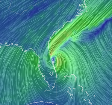
This is the CENTER of #IAN
Still off land officially.
Moving North...
Pawleys Island
Murrels Inlet
Myrtle Beach
In it's path....
Impacts already far inland.
As I have written about.
Surf, Storm Surge.
Pier at Pawley's Island collapsed........
...parts seen floating South :(
As I said earlier, it's a disconnect when you see the weather far inland and the eye has not come ashore yet.
Part of the boardwalk in Myrtle Beach washed away.
Part...
More to come...
..waiting on official landfall.
But IAN already here.
I have to stop calling myself a Miami girl...
...really a Carolina girl.
This is personal for me..
stay tuned.
As I have been saying Myrtle Beach is closer to landfall.
The Cone keeps pulling to the right. East.
Just a drop but extrapolated that makes a difference.
Inland differences as to how strong your wind will be.
Note 14 MPH forward speed.
This is FAST for IAN.
Speeding up.
85 MPH.
Discussion from NHC.
As I said.. MOVING FASTER TO THE NORTH
Should ACCELERATE to NNW later.
Or more to the N.
This is evolving in real time.
IAN may not be Cat 4 FL Hurricane.
But it will be remembered here in Carolinas.
Eyewall has formed...
... a work of tropical art evolving in real time.
Dangerous but beautiful from satllite imagery.
This is a classic NC VA signature for tropical weather.
Ryan Hall is covering a wide array of areas.
Bringing fast info as it happens.
Every YouTuber has it's own flavor and people enjoy one vs the other, I'm posting him here as he is in real time watching DIFFERENT areas not just where "landfall" may be and IAN is about more than landfall and storm surge, but inland impacts in areas where hardwood trees snap, crack and fall onto people's homes, highways and create havoc as people lose power. And, inland people are out and about "at work" and they will suddenly need to get home if the wind begins to ramp up and that will cause more traffic accidents, problems and this is the problem with the messaging.
The message should be FIRST LANDFALL NEAR ______ but IAN is moving FASTER and STRONGER and may impact areas INLAND such as Columbia SC, Wilson NC, Greenville, NC, New Bern NC so check with your local weather experts and National Weather Service. Keep phones plugged in fully charged and make sure your WEATHER ALERTS are ON! They still make Weather Radios, if you have one now is the time to actually use it!
This is why local weather updates are important!
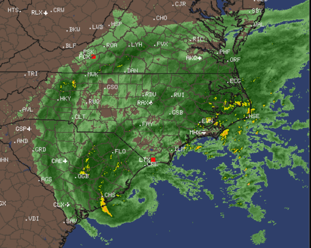
Radar shows rain everywhere.
Currently strongest near center and Wilmington.
I went out early to get a few things and to look around. Two different movers are moving people in and out of apartments in steady rain and both of the movers looked at me as if I was crazy when I said "do you know we have a Tropical Storm Warning?" and they did thank me and I did tell them to stay away from the areas that normally flood and be careful of trees that night fall and that is the mentality often in Raleigh where real weather rarely happens. Uusually Greensboro steals the snow in the winter and thunderstorms in the summer so at all times people assume they won't get anything and barely pay attention to the local weather.
I'll tell you what I see. Light rain to more steady rain and over the last hour the wind gusts have picked up, but they are not strong gusts but they catch your attention. The forecast yesterday was all about Charlotte getting the "center" and now those lines and models are over the Triad (Greensboro, Winston-Salem) and edging towards Raleigh. That means Rocky Mount, Greenville will all get stronger impacts (in theory) today than they expected yesterday.
The media is at Charleston and Asheville, but I'm thinking they should be near Wilmington NC and Columbia SC or Fayetteville, but TWC doesn't usually go there and everyone wants to know landfall. But, this is about landfall first and inland impacts as IAN can pick up speed (already has) and when it punches North fast those stronger winds and random wicked gusts will slam an area convinced they "probably won't get much" and seeing how TWC is down in Charleston and it's barely raining in Raleigh people just aren't believers yet.
I'm going to go off for a bit and listen to a good friend and do my thing and watch it come in both in real time, inside and whatever happens here when I am in Raleigh I'll update to Twitter or put here later.
Every hurricane that surprised Raleigh (and other cities inland) did so as it strengthened and accelerated foward speed moving in fast going from "oh just some light rain" to "oh my gosh that pine tree just fell down" so please prepare for the worst, hope for the best and adjust in real time to your own local weather. Local NEWS is LIVE talking about the Carolinas nonstop so if you have Cable or can watch on HULU now is the time to watch your local news.
Stay off the roads, if you are on a road do not take detours stay on the main highway, and if you can stay home just do it or stay very close to home... if you can.
More later......... please keep reading it all implies.
In the last 15 minutes my curtains started to fly and dance around a bit and the fan by the window that is partially opened began to spin. So know things will pick up sooner than you realize.
Surf at Wrightsville is awesome, I'd be there but it's Friday and I do the Jewish Sabbath thing that starts on Friday Night into Saturday so I'm home in Raleigh watching friends at the beach! In NC not just down by Charleston...
***
I'll update after the 11 AM to see how if at all the NHC updates their information or cone to any degree. Models have shifted to the right and I'd look at the SC/NC border for landfall of IAN. Myrtle Beach is just to the South of that boarder it's a short ride up the coast to Wilmington/WrightsvilleBeach.
UPDATED Midnigh 85 MPH Hurricane - Recon 100 MPH Gusts! The Day AFTER in Florida - The Day Before in Carolinas. Ian Part 2 - Flooding Likely For Carolinas. High Winds Possible. Tropical Storm Warnings UP!
I wasn't sure I was going to update as the 11 PM, while 5 MPH more than earlier, has been an extrapolation of the previous advisory for the most part. Models tend to show landfall further N than Charleston, but again as I said do not focus on #Charleston but #Carolinas. Weather arrives far in advance across the Carolinas of the eye coming near the coast. And, Ian is stengthening over the warm waters of the Gulfstream.
This graphic from West on air tonight shows the problem.
Wild weather with gusts of TS force are out ahead of the center.
No this is not your nomal Hurricane.
But it has Hurricane force winds of 85 MPH at Midnight.
Not sure what they will be at 5 AM.
But I wouldn't be surprised to see 90 MPH.
Or higher.
Ian has a nasty history of violent weather.
Rarely do I hear talk of 50 MPH winds in the Triangle.
Again IAN hasn't made landfall and the weather is here.
So take this seriously.
Stay home if possible.
Hunker down...
...keep phones charged in case power goes out.
Normally in the Carolinas we don't expect to get much even when we have a Winter Weather Warning or a Tropical Storm Warning. Flooding happens in the places prone to flooding and down by the coast it's a mess. But IAN seems to be the exception to the rule so far on many levels, so prepare for the worst, hope for the best and hopefully it will be kinder to the Carolinas than it was to Florida, but I wouldn't bet money on it.
Ps speed could move up and be faster.
Winds could be stronger.
Too many unknowns.
So prepare and stay safe!
Night....... Will update in the morning.
Til then this is as relevant as it gets.
Stay safe!
****
It's rare for the NHC to put out an update 15 minutes after the 11 PM advisory. Recon found stronger winds and gusts of 100 MPH so the wind intensity was upgraded to 85 MPH from the 80 MPH wind speed at the original advisory. That's fairly impressive intensifying for what should be a tired hurricane relic looking to retire somewhere. But, no Ian just keeps on going.
Tropical Storm Warning in Red
Hurricane Warning near the coast.
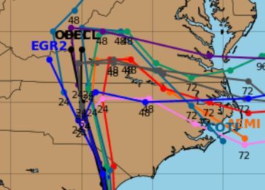
Models in agreement towards landfall.
But they disagree down the road.
Best not to look at the models that loop about or go to the South later, it's a complex situation and as Ian goes Hybrid it has multiple components in it and often as they move East eventually out to sea they do strange things and that is what those models are seeing. Other models take this up towards Pennsylvannia so don't focus on models focus on your local weather people and the NHC infomation. You know, go straight to the source.
The interactive cone...
..always shows stages of wind field.
Discussion from the NHC mentions models.
Most of the models pulled to the right.
So cone was a bit further East than 11 AM.
Many models bring it in closer to Myrtle Beach.
Again new cone is at 11 PM.
Understand these beach cities are up and down the coastline. They are my beaches, places I love and that we often travel to so when in Myrtle Beach we often drive down and spend the day at Pawley's Island as it's my happy place. Sometimes when we stop in Savannah on the way back from Miami we drive up the coast to Charleston for the sheer beauty of the trip where I take in the Low Country and enjoy the feel, the smell and the lay of the land. So don't get lost in the drama of #CHARLESTON in the way many got caught up in the media frenzy of #TAMPA and Ian came in to the South of Tampa in an area where many insisted they were sure it would go to Tampa and didn't expect it to come in where it did. That happens every single time on the West Coast of Florida. Don't get caught up in Hashtags trending on Twitter or the media frenzy of going to the more well known city and know it can make landfall at a small beach no one has every head of...
An example being Hurricane Matthew.
Despite talk on Charleston it made landfall by the red dot. McClellanville, a rural town to the NE of Charleston.
Don't get locked in to media frenzy.
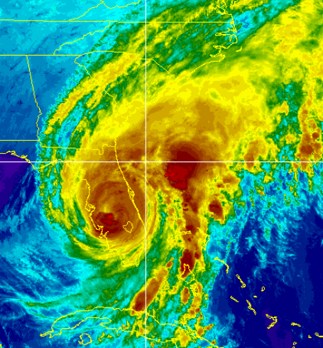
The whole area from Daytona to Wilmington NC...
...is getting wild raging surf aka IAN.
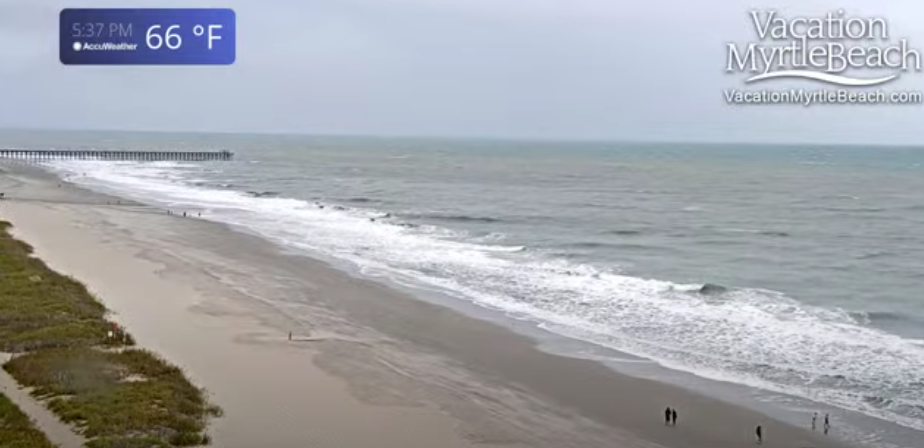
This is a current image from Myrtle Beach.
I'll leave the link below.
I often watch sunrise on that site..
Yes, it's 66 degrees.
Foamy beach already.
My Tweet showing how close landfall models were.
Yet, strong weather sets up different ahead of it.
AGAIN WEATHER moves AHEAD of landfall.
A hard message to convey.
People are used to the opposite.
This is an image of Wes in Raleigh on air trying to explain that at NOON TOMORROW the WEATHER has already spread out into the forecast area yet Hurricane Ian has not yet made landfall or is about to. Normally people expect the opposite and yet this is a tricky storm to explain as I said it is a Hurricane but it's moving towards Hyrbrid status like Sandy did and well if you remember once there was Hurricane Grace and then it all became The Perfect Storm a huge Gale system. Weather spreads out, up into Virgina and further up the coast so this isn't just about the Carolinas.
Don't get lost in the name, prepare for the weather!
That's my main message tonight.
That and I have a friend who knows weather and he always says the problem is people always prepare for the last hurricane they had and the new hurricane brings it's own surprise. This is not Matthew, it's not Florence and it's not Fran it's IAN and IAN has a deadly history of flooding and strong violent winds close to the eye, as well as storm surge on the beach and places where we often have flooding overwash the coastal roads. Locally in Central NC we could get flash flooding in the places that always flood and I'll say it again rain + terrain = Flash Flooding! 40 to 50 MPH gusts and a stray, random tornado. This is NOT JUST a Tropical Weather event as the weather is on the chilly side and tomorrow it will feel more like a violent Cold Front with temperatures in the 60s but with tropical feel to the air.
As for the devastation in Ft. Myers area and the continued search for those who are injured or possibly dead under flood waters the search goes on while some clean up know it will be a long time before that part of the country will be the same again. Nature returns to it's state but homes by the coast that storm surge trashed and roofs that were damaged or blown away will take a while to repair as the devastation is across a wide area and that area moved NE with Ian to Orlando where there is more damage and then the NE coast of Florida where flooding closed major highways. It takes time to put things back together and more so to get final totals for how many died, how many are missing and how many were injured.
Do not assume it won't be anything "because it's not a Cat 4 Hurricane like it was down in Florida" which I heard about ten times today as I listened to people talking in TJMaxx when I went to a walk to get away from it all a bit. No, it won't be like it was when it was a Cat 4 but we have pines and oaks that crack and snap in the Carolinas so prepare now and don't wait for Ian to make landfall on the coast as it will be too late as the weather will aleady be there.
Expect surprises but don't expect this just to go away because you can't wrap your head around it.
As I said I do love Charleston although I love Savannah more. And, I love Pawley's Island and Myrtle Beach so this here is very personal for me and again I have a Tropical Warning that means I should expect to feel tropical storm force winds tomorrow!
The area from Savannah to Wilmington, North Carolina are under the gun for strong winds, flooding rains as the "center" of Ian moves towards Charleston, SC. This area is one large beach area sort of anchored by those two cities with Charleston the well known middle. It's filled with beautiful Low Country, Marhes and beaches such as Georgetown, Pawleys Island, Murrels Inlet and up the coast to the NC line to Wilmington that will get high surf, flooding rains and strong winds. We aren't talking about a strong hurricane we are talking a high end Tropical Storm or borderline Hurricane, but the impacts will be the surf and the rain and rain in the Carolinas where there are River Basins and terrain always mean flash flooding probable. A river basin is the area where crops often grow as it's fertile land and many people live wonderful lives until they flood; they are basically a flood plain in the river basin and that is why the Carolinas are prone to repeated flooding from tropical systems such a Floyd, Fran, Florence, Matthew and many other weaker storms that had smaller floods but flooding none the less!
All converge on general Charleston area for a 2nd landfall.
It could be further South or North but nearby.
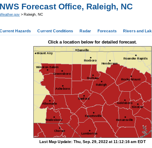
To complicate matters these impacts are FAR from the center of the Cone that tracks the EYE so do NOT think you're fine if you are a newbie to the Carolinas and not in the eye but just the opposite. The long duration rain event that could go on way after Ian winds down as it mixes it up with another feature that lingers. For example the forecast for Raleigh below is an area not in the Cone but in the Zone for weather impacts! The two images side by side show this problem. The WHITE CONE hooking to the left on the 4th and 5th day is the "wind" and "center" of Ian, but the image on the right is the heavy rain totals and possibilities for flooding in the same area that is to the right of the cone on the left. The large orange circle in the image on the right is the WIND impacts of Ian which go FAR out from the cetner of the Cone. I sure hope that makes sense to you, you may have to read it twice. If it doesn't and you are new to this area ask an old timer and they will explain how the weather drama doesn't always follow the inside of the cone.
Some conditions from cities dealing with IAN currently.
High gusts along the Florida coast.
Some flooding going on as seen below.
An Iconic landmark for many of us NASCAR fans.
As as he can always be so dramatic and cute....
Dabuh does it his way.
That there is the center of IAN
leaving land, moving out over the Ocean!
And now the drama begins.
No real intermission here between Acts.
Ian on Earthnull
So personally I'm tired and taking a break for a few hours to just "take it all in" and watch the impact of IAN in Northeast Florida an area I am no stranger to as we spend a lot of time in the Jacksonville/Ormond Beach aera on trips to and from Miami. I need to check in with a few friends who gave me the "thumbs up" symbol last night that they were okay in the area where Ian made landfall. They stayed as they have people there they work with who may need help after the storm and they are okay, not sure on their friends and people they were worried on in their synagogue. I want to watch some video from friends of mine who chased Ian. I want to just rest a little bit and take it in. On an oddly personal note our car is in the shop in Raleigh and being worked on and as that area is prone to flooding they "moved the car" so work on the car will be delayed though the rental will be nice I'm sure. Crabtree Creek in Raleigh floods often and many of the car dealerships are adjacent to it and at the mere suggestion of a tropical system they move everything to higher ground fast.
Again you learn from history when you live in a region that has repeated tropical events that are all similar but always in some way unique. Kind of like we are as people, we have commonalities and yet we have our own unique quirks and qualities that make us who we are...
The clean up in Florida is just beginning. So far there is one official death from Ian and sadly I'm pretty sure there will be more and if not that would be a miracle. Way too many people stayed in old apartments and homes on barrier islands where lanbdfall occurred. I'm still unclear why the Naples Fire Department and Police did not move their vehicles, especially that brand new Fire Truck to hire ground as it was obvious they were going to have severe flooding even if IAN was just cruising by on it's way somewhere else. I mean the car dealerships in Raleigh have moved their cars already but the Fire Department that should have been aware of the dangers did not? I'm sure there's more to that story, I don't like to judge other people's decisions but it seems a no brainer. I can rant later on the press making the message by talking nonstop about Tampa and Ian and many I spoke to personally told me "well they thought it was going to Tampa" and perhaps that's partly denial and how we live in the tropics always hoping a hurricane goes somewhere else but the message needs to delivered that it is not just about Landfall but the STORM SURGE and FLOODING that often reaches far inland, but rearranges everything at the coast as if a bulldozer was sent in to demolish what was to build some new shopping mall. After Michael that message should have been clear, and yet it wasn't. We have to do better!
Stay safe and keep watching the tropics. I hate to tell you the obvious but just as Ian is not done with us yet, the tropics are not done with us yet.
TD 11 far out to the sea on the left!
Strong convection moving westbound in the Carib
Purple possibilities on the map below in 48 hours.
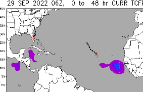
IAN Crossing Florida. Watches & Warnings Go Up the Coast for Ian Part 2 JAX - Savannah - Charleston - Myrtle Beach Carolinas in the Cone Again!
11 PM Cone for Ian
This is the NRL (Navy) Cone for Ian.
It works off of the NHC cone...
...has larger wind field areas.
Ian is part of a complex set up.
It's over Florida currently.
An odd looking area of convection offshore?
There are warnings up for Myrtle Beach.
Tropical Storm Warning!
And several days of strong weather.
It makes sense that after Ian did Sanibel Island, Orlando and crosses what used to be the Sunshine State it wants to do Charleston and Myrtle Beach; it obviously checked out the tourist brochures before it began this ardous journey.
And this is the rain forecast from Ian after Florida.
A true rainmaker.
It's very common for a Florida Hurricane moving NE across Florida to make a second landfall in Savannah, Charleston or further up the coast near Myrtle Beach and the NC state line. St. Marys Georgia, impacted horribly by Irma, also has surge warnings up! Inland across SC and NC and even near the TN line if some models are right they will have a mix of tropical weather and cool fall air clashing! Savannah actually gets hit more often from the backside than from the Atlantic side!
So it's not over til it's over.
The clean up across Florida will be immense.
It will take an army of linemen to get the power back on. In Cuba the power is not on yet in most places.
An interesting loop for the image below is here, enjoy it.
Location: Miami, Raleigh, Crown Heights, Florida, United States
Weather Historian. Studied meteorology and geography at FIU. Been quoted in Wall Street Journal, Washington Post & everywhere else... Lecturer, stormchaser, writer, dancer. If it's tropical it's topical ... covering the weather & musing on life. Follow me on Twitter @ https://twitter.com/#!/BobbiStorm