Update Landfall IAN 85 MPH Georgetown SC Just N of Pawleys Island Pier Washed Away, Murrels Inlet South of Location by NHC - Part of Myrtle Beach Boardwalk Gone... Dangers Across a WIDER area - Impacts From Greensboro to Wilmington, RALEIGH WILSON GREENVILLE NC
Official Landfall by NHC

Georgetown, SC


This is why local weather updates are important!
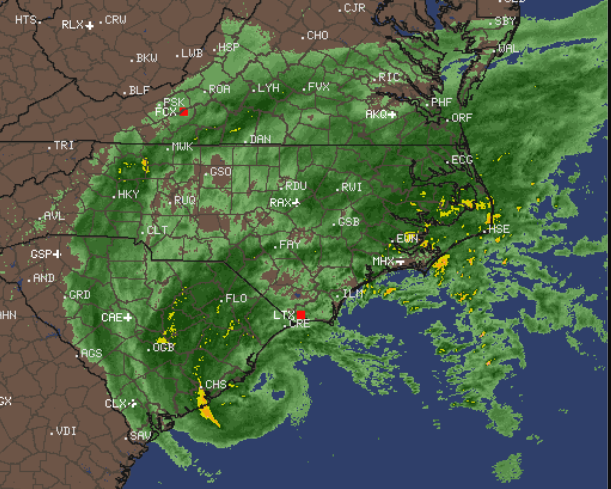
Radar shows rain everywhere.
Currently strongest near center and Wilmington.
I went out early to get a few things and to look around. Two different movers are moving people in and out of apartments in steady rain and both of the movers looked at me as if I was crazy when I said "do you know we have a Tropical Storm Warning?" and they did thank me and I did tell them to stay away from the areas that normally flood and be careful of trees that night fall and that is the mentality often in Raleigh where real weather rarely happens. Uusually Greensboro steals the snow in the winter and thunderstorms in the summer so at all times people assume they won't get anything and barely pay attention to the local weather.
I'll tell you what I see. Light rain to more steady rain and over the last hour the wind gusts have picked up, but they are not strong gusts but they catch your attention. The forecast yesterday was all about Charlotte getting the "center" and now those lines and models are over the Triad (Greensboro, Winston-Salem) and edging towards Raleigh. That means Rocky Mount, Greenville will all get stronger impacts (in theory) today than they expected yesterday.
The media is at Charleston and Asheville, but I'm thinking they should be near Wilmington NC and Columbia SC or Fayetteville, but TWC doesn't usually go there and everyone wants to know landfall. But, this is about landfall first and inland impacts as IAN can pick up speed (already has) and when it punches North fast those stronger winds and random wicked gusts will slam an area convinced they "probably won't get much" and seeing how TWC is down in Charleston and it's barely raining in Raleigh people just aren't believers yet.
I'm going to go off for a bit and listen to a good friend and do my thing and watch it come in both in real time, inside and whatever happens here when I am in Raleigh I'll update to Twitter or put here later.
Every hurricane that surprised Raleigh (and other cities inland) did so as it strengthened and accelerated foward speed moving in fast going from "oh just some light rain" to "oh my gosh that pine tree just fell down" so please prepare for the worst, hope for the best and adjust in real time to your own local weather. Local NEWS is LIVE talking about the Carolinas nonstop so if you have Cable or can watch on HULU now is the time to watch your local news.
Stay off the roads, if you are on a road do not take detours stay on the main highway, and if you can stay home just do it or stay very close to home... if you can.
More later......... please keep reading it all implies.
In the last 15 minutes my curtains started to fly and dance around a bit and the fan by the window that is partially opened began to spin. So know things will pick up sooner than you realize.
Surf at Wrightsville is awesome, I'd be there but it's Friday and I do the Jewish Sabbath thing that starts on Friday Night into Saturday so I'm home in Raleigh watching friends at the beach! In NC not just down by Charleston...
***


posted by BobbiStorm @ 7:10 AM
![]()


0 Comments:
Post a Comment
<< Home