6:30 PM
Not much to add, follow the NHC and pay attn to Mike's updates on YouTube or Facebook. As a matter of fact he's talking now as I type looking through models. What will be IAN looking better every time I look, but it's still a bit of a mess. It is forecast not to be a mess in 3 days. People in the Miami metro area are feeling a bit better tonight, but from Tampa to Tallahassee they are not feeling as safe.
My real question is about the fast movement at the end, that could verify but Ian has to go through the loops the models have shown it can do. I'll be off Saturday and be back online after the Jewish Sabbath around 7:45 in time for the 8 PM... give or take.
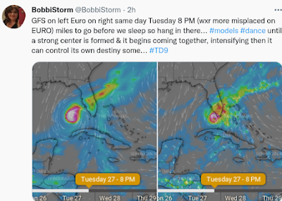
I expect to see TD 9 ..TS Ian by then. If not, their intensity forecast was off. Going with the models shown below and remember that in one day a model went from Houston to Nola back to Florida, so they do get a bit wonky.
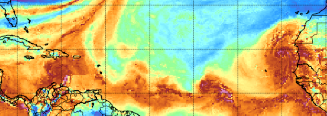
Last image... check out Fiona's influence on Ian
Note the SW to NE lines.
Note the line of storms over Florida.
Connect the dots.
This is not a normal Atlantic.
Are the models reading this right?
Even without models I'd put this up by Big Bend of FL.
This to me is a question... everything is off.
Fiona is a massive hurricane still 125 MPH.
Even the wind graphic for TD9 Ian shows Fiona
Top right corner.
Do not underestimate the impact from Fiona
Keep reading please......
and follow NHC
Know track can flip back to the East...
or stay the same.
Things change in real time...
...once we have a well developed storm not a TD.
Stay SAFE stay INFORMED on the STORM!
* * *
5 PM
Cone remains fairly the same.
Minor adjustments.
Also note space between 3rd day and 5th day.
This *could* come in fast and strong.
Any change in track could take many by surprise.
And I mean small changes not big ones.
Do not focus on the center of the cone!
State of Emergency declared for 24 countines in FL.
TD 10 now Hermine
IAN will be Florida Cane
You can see the difference between TD9 and TD10
That is why TD 10 is now Hermine.
Earlier today I wanted a map from the NRL site.
And, I saw NRL upgraded to Hermine.
Really, they are never wrong.
Leaving the I name to TD 9
Ian replace IRMA
Irony
Most of Florida is in the shaded zone from NRL
Part of Georgia.
Wind Probs go up the coast to Myrtle Beach at 5 PM
Bald Island NC...
Not much to add, still waiting for TD 9 to get the name Tropical Storm Ian and to see what Ian does and if it does indeed intensify when shear decreases and to see if the forecast High Aloft forms and it's able to intensify fast into a Hurricane. Until those things have happened, no model will be 100% right and that's why the NHC uses many models and adjusts as they see fit to make a reliable cone.
Intensity forecasting is the holy grail, we aren't there yet sadly.
Please keep reading I'll update around 6 PM with more discussion. At least we know we are dealing with Ian not Hermine ... all the MEMES were mostly wrong and will have to be redone. As for Hermine, she's in Africa and the name most likely will remain on the list down the road.
EURO now comes in closer to Tampa.
Models will move around for a while.
as usual I'll be off Saturday until after sundown.
Thanks for your patience, I can really use the rest!
4 PM Discussion still very relevant.
But EURO pulled N on the last model run.
Next model run is anyone's guess.
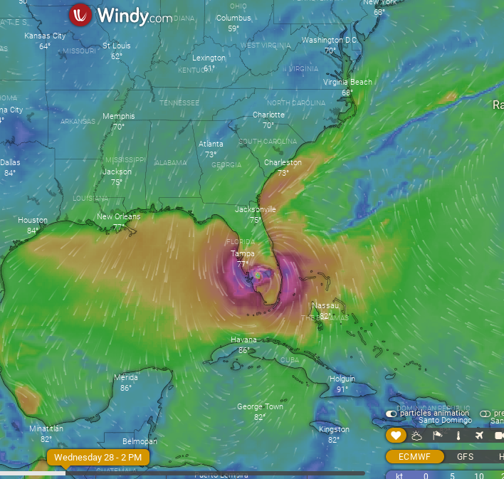
Recent model images for landfall.
They change constantly.
The theme in this blog is not landfall.
I want to discuss the beyond landfall possibilities.
Also the issue of Tampa Bay.
As it comes up in the media often.......
Never lock in on one scenario this far out...
...and remember this could have multiple US landfalls.
I want to put some thoughts out that haven't been mentioned as much online and need to be addressed. So starting an Afternoon Blog that I'll update at 5 PM. Everyone is asking where in Florida TD9 will make landfall. As a born and raised Miami girl I totally understand the concerns here and seeing as my family lived in Tampa since 1900 I totally get the concern for Tampa Bay. Before Tampa, they lived in Key West in the 1800s and every hurricane that has taken the track of many of the models is currently dancing and pirouetting through my head. That said, the hurricane that should form from TD9 is not Charley (mid August storm) and not the Tampa Bay Hurricane of 1921 that made landfall in late October.
This may not even be a Tampa Bay hurricane as many storms seem to aim towards Tampa and suddenly veer off to the South or the North to a landfall far away from the city built on Tampa Bay. A strong front dips further South and more often they are too far South for a typical front grabbing the storm set up.
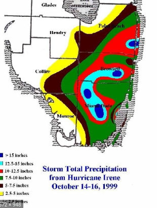
Then we have Hurricane Irene that the NHC tracked to the West Coast of Florida yet it's naked center was far from it's intense rain that flooded Southeast Florida as seen by the graphic below from the NWS.
So there are many questions on TD 9 not to mention if this is Hermine or Ian, oh my gosh the drama is real.
What I want to talk about is that rather than focus on landfall in Florida, it might be important to focus on the impacts further down the road as some models take it up the spine of the Appalachians and that could lead to flooding across a large area. It may not happen, but it's there in the end game runs that aren't shown in the 5 day Cone. So note the model shown below and way after landfall it's tracking inland up across areas that could see flooding due to the terrain.
Our ever changing models.
Honing in on landfall maybe...
...yet where does it go after that?
How much more damage can it do after Florida?
GFS for October 2nd.
Could TD9 get this far North and stay inland?
From here it moves up into the Northeast.
After what happened with Ida after landfall in GOM.
It's worth thinking on and remembering this is complex.
The EURO moves it faster and takes it offshore FL.
After landfall wherever......
It ends up strong over the Gulfstream.
Delivering heavy rain, wind to FL, GA, SC and NC
It does the Outer Banks
And then continues up towards NY and NE
Couild this happen?
Sure, maybe.
Time will tell.
But it would be a huge track of terror if so.
A different track of terror than an inland track.
My point here is that it is not all about "landfall" as much as we worry on landfall and prepare for possible landfall, this storm now down by South America in the Caribbean trying to fight off shear and attain it's name has a long way to go before any of us sleep if the general consensus of it developing into a Major Hurricane.
And before the Icon hits South Florida...
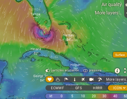
...it rams into Cuba.
Again these wonderful images from www.windy.com are really only a photograph in time based on the current conditions and as the atmosphere is in disarray still from Fiona, it's possible things change often between now and landfall.
Charley made landfall in August, usually it would not be expected to hook in to the right and yet it did. I wrote about this before it made landfall in the post shown below. How much shear will there be as the storm approaches the front? Yes, conditions seem perfect in the Caribbean but as hurricanes move North towards landfall shear often appears. There's an ULL and they are tricky to forecast and can help ventilate it or tear it apart.
I want to see what this storm is like after it develops before posting thoughts on landfall beyond what I have said frequently here and online.
Easy money usually is on a landfall North of Tampa that will push water up into the bay often creating flooding and crossing the state further to the North. However, I can see the window for movement across Florida for a track up the Keys towards Miami.
The track Hermine or Ian takes towards landfall, the intensity and the speed will tell the second or third part of the story. It would be kinder if it simply does it's thing in Florida after Cuba and goes out to sea but I doubt that is going to happen.
Here is what I wrote about Charley before landfall and I knew it was going to hook in and talked on it often online and in the blog, but the truth is we were close to landfall and it was fairly easy to read the possibility from satellite imagery for me but currently we have a tropical depression far to the South still near South America, we are not there yet.
I was pretty sure Charley would go right of track.
Yet I could see other scenarios but my gut said it would hook in.
Stay tuned........
Again IF the 5 PM shows fast movement on the 4th and 5th day then it's imperative to know what you need to do so you can do it fast if the forecast track moves towards your location.
I'll update later with the 5 pm.
Just some thoughts on the longer term track and the possible impacts this storm can do way down the tropical road.
Besos BobbiStorm
@bobbistorm on Twitter and Instagram
Twitter mostly weather and Instagram whatever........


2 Comments:
Thanks for your update! Been quietly following you for years, always appreciate your thoughts. I remember many times when you were right vs what many others had predicted. (Though one question on the name replacement -wouldn’t Irma have been been replaced with a female name, not a male one like Ian?)
It's 7:30 time's a wasting.
(thanks for all you do - shabbat shalom)
Post a Comment
<< Home