Updated 5 PM - Fiona 60 MPH Moving West ... So Many Questions. NHC Cone & Models Pull Fiona North... BUT...Where and When? Hurricane History Lessons Today from Dorian & Matthew at the Same Point on the Map...

5 PM
Discussion highlights.

Being honest this is kind of interesting. It's there way of saying "yes it does appear she lost some latitude (more to the S) but general track is to the West. It would be like saying "yes I did party all week on the cruise and ate like a pig, but I'm basically the same weight" if you know what I mean. It may mean something or it may not but Fiona is a WEAK storm not properly aligned and with the shear it's easy for it to drift South of West but the FORECAST track IS WEST ...for now. And, a lot going on in the storm today and as I say always time will tell.

Yes the circulation is to the W of the blob.
But the winds in the blob are now 60 MPH.
More discussion on the discussion..

Low confidence in the 4 to 5 day forecast.
Gee...thanks. Honesty is the best policty tho!
"anywhere from eastern cuba to well to the NE of Bahamas"
Wide range of possibilities.
The timing is just very off for it to race off out to sea. Sorry but true, though not taking out to sea out of the possibilities and usually storms do find a way to find their way out to sea. But, flooding will occur in Hispaniola (if it doesn't go through the Mona Passage) but either way PR should get a lot of rain. And, if it slows down.............. that's a lot of rain and it's late for it's date with the front. And, I'm not in love with the front that IS nice to see but not all that cold of a front. But, then again there's another front.
This is really a classic set up for September....
The EURO is smells weak and takes it further West (logical) and keeps it further South (logical) than the hot to trot GFS that wants to grab it like a football in a fumble and run for the end zone.
Keep watching... keep reading and we will see what the infamous GFS does at 18Z but IF it leans to the left towards the EURO there won't be any water left in South Florida :( at Public. Avoid hype at all costs and take it advisory by advisory and model run by model run we are DAYS away from being fairly sure just what Fiona will do and the NHC said that in their honest discussion. Below you can see the EURO model that is making people in Florida take a second look at Fiona. Often when this happens it slides along the coast and crashes into North Carolina, but not always. Just something to think on... but this is NOT Earl.
Latest EURO....
...broke from the pack.

Far out.... much can and will change.
Just one model run.

Many models still turn right.
But closer to land.
Ensemble models everywhere...
...even into the GOM.
But logical IF Fiona stays weak!
And moves slowly.............
Going out for a drink/dinner with husband.
So.... I'll be back later tonight.
* * *
11 AM from the NHC


Cone wide on the 5th day.
Narrow in the short term.

I suggest you read the discussion.
Above it shows models disagree on speed.
Forward speed impacts track.
NHC favors "less-intense scenarios"

Yet they hold the door open to it being stronger.
As in currently stronger.
Recon will get facts.
Fiona not properly aligned.
But carrying powerful TS winds.
Moisture and headed into the Islands.

Interactive Cone shows Warnings.
Warnngs will be extended West as Fiona moves West.

A collage of images.
Take Fiona as a whole package.
Yes TS winds to East of Center.
It's bringing TS winds to the Islands.
Westbound... as you can see on Mimic (orange)
My thoughts haven't changed and we basically are watching, tracking, studying Fiona as well as the steering currents that often ebb and flow much like Fiona. The Atmosphere is a River flowing and often surprising us with a stronger than average cold front in September and sometimes part of that front collapses. Sometimes the High builds in stronger and shear relaxes and other times everything goes as smooth as clockwork. That means you can totally rely on the forecast verifying, but currently the NHC is extremely honest in their discussion on how low confidence there is at the different factors yet despite the different factors they have to make a Cone and put out a forecast and that's their job. They do a good job. Yes, sometimes a forecast is busted but as a famous meteorologist once told me "usually it's the big ones that bust the forecast" and currently we have a Tropical Storm and Fiona isn't there yet.
Keep watching. Keep reading. I'll upload the jagged sort of video I did this morning while watching the Mimic, a loop that like the Water Vapor, often foretells changes down the road that will impact a storm or that reinforce a forecast. I'll leave the 11 AM update with a great Tweet by Chick in NC. Well said. Stay tuned... I'll update later this afternoon with the 5 PM and or if something changes.

I'll add in NC has a history of too many bad F storms...
... something else he mentioned.
Fran Florence to name 2 ...
Keep reading, thanks.
I'll change up the song later so check back later!
And remember to follow me on Twitter @Bobbistorm
****

Putting this at the top not the bottom... This is the Bottom Line from the NHC... Fiona moving WEST at 13 MPH packing winds of 50 MPH and it's forecast to make a turn to the right (N) later in the forecast period. The cone is below and you can compare and contrast it with the one that will come out at 11 AM.

Everyone talking about possible tracks online and offline as some people talk about the tropics around the dinner table or at Starbucks or Chili's not just online. For this forecast above everything has to validate and if not there is some subtle change in track and or intensity.
1. Forward Speed impacts track as it needs to catch that front...
2. Intensity because a stronger storm will want to pull North faster vs a weaker storm West.
3. Islands in the stream: Direct hit on Hispaniola or avoiding it somehow.
4. Alignment of Fiona with her mid level center not aligned (due to shear) with it's center.
What do we learn from recent history? Things can change fast. Below is an example and I am NOT saying Fiona could explode like Dorian, I am just showing how at this same point in time there were many questions on Dorian and Dorian was fighting shear and weak. Just a lesson in Hurricane History.

That "ball of convection" was Dorian.
Something changed.......
Let's look at Matthew in the same area.
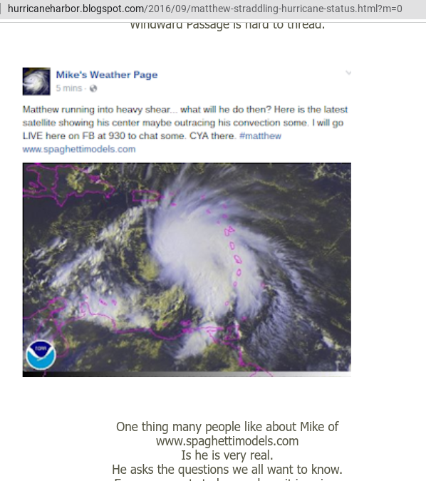
Matthew looked better BUT....
Convection sheared East of Center.
Very obvious in image above!
NHC was all about the SHEAR!
But something changed.

Models showed smooth steady movement.
Totally busted forecast.
Busted forecasts happen less than you think.

Note how long Matthew stayed down by SA.
Barely moved. Intensified into a MAJOR
Despite shear, despite nearness of land.
Matthew is that exception to the rule.
For now Fiona has been stubborn.
And y'all know how I feel about stubborn storms.
Earl formed into a Hurricane because it was stubborn.
Fiona is a Tropical Storm despite shear and stubborn.
So what will Fiona really do in real time?
Models at 10 AM

Models call for a turn to the North.
Where and When?
I'll update today at the top.
Stay tuned and thanks for following.
Besos BobbiStorm
@bobbistorm on Twitter and Instagram
Twitter mostly weather vs Instagram whatever.
Ps everyone wants to know about Miami.
Why?
Because everyone has a cousin in Miami.
Doesn't mean it's going there... just a cute song!
It'll turn ... but where and when?
https://www.youtube.com/watch?v=Yv1zh5lu03I
posted by BobbiStorm @ 7:18 AM
![]()


0 Comments:
Post a Comment
<< Home