FIONA - NHC UPGRADED Special Statement! -Waiting on Recon to See What's Under the Hood. Typical 2022 Fighting Off Shear Stubborn System.
Tropical Storm FIONA
50 MPH!!

Special Statement.
11 PM Will have more details.
As well as I imagine watches and warnings.

Dvorak is an old school tool.
But a great one, especially at night ...
...or before Recon goes in.
You can Google it....
...but trust me it works!


By every measure we have available ...
TD7 is Fiona.
Morning Visible tomorrow and Recon data.
11 PM Coming out later but...
... well done. Deserved the Upgrade.
Watches need to be put in place.
Places immediately in the path of Fiona

Earlier this evening below.
Keep reading if you have now.

Close up...
...far away.

That's impressive.
Being honest.

Good graphic from Twitter.
A big issue here is timing and the EURO and GFS differ tremendously. Perhaps the one seems a stronger storm and it's more prone to feel the pull of the Poles and the other is weaker, moving along slower ploughing through Hispaniola and losing it's mojo. We will know soon enough in real time and it's possible Fiona itself will show us the answer.
Understand there are so many worst case scenarios for different places to end up hosting Fiona as an unwanted visitor. A case could be made for different parts of Florida; Miami/Florida Keys storm or North of Daytona? Is this just your typical "scare every town along the way and clip OBX on the way out to sea" or "Does it pull North and miss it's ride out of town and get trapped under a ridge?"and if it did go through the Florida Keys could it keep going into the Gulf of Mexico?" Too many possibilities and not enough information. And, I will remind you that I have seen many a Tropical Storm or Hurricane forecast to slam into Hispaniola and have it miss it by miles and end up regrouping NE of there and turning into Dorian. And, I heard so many mets explain why Jeanne was dead because of Hispaniola and then she was reborn after a wild loop out into the Atlantic and turned back and slammed into a part of Florida that rarely gets hit.
So check out your hurricane supplies if you think someone may have been raiding the locker you didn't lock good enough and make sure you have medication on hand that you need and sit back, follow your favorite weather experts and as always listen to the advice of the NHC.
Below is the NRL map I like as it goes out one bit further and in this case the Navy has to worry about it's ships at sea... so yeah, it's a good map.

The link below is the link to use if you want to follow TD7 and it's current explosive energy burst this afternoon. Can it maintain that? If so we have a real storm. If not we will wait for recon to go into this and see what data they can get to put into the models to get better models.
https://www.tropicaltidbits.com/sat/satlooper.php?region=07L&product=ir
Models for Tropical Depression 7

Keep reading if you didn't earlier...
...from 4:30 PM below.
Most models show it curving to the North, while one stubbornly takes it into the Caribbean. Odds are it turns more to the right (North) but when and where. Often the cone is generally correct but timing is off, and when that happens the cone slowly edges about over a while. Once Recon is there and the plane that samples the environment we will have better data, hard data, on elements in the atmosphere that will make all the difference. I'll update at 5 pm. As always a stronger storm leans more to the right (North) and a weaker storm tends to wander West; there are exceptions to everywhere rule.
Currently the NHC is forecasting a weak end Tropical Storm, but intensify forecasting is the Holy Grail and we have not found it yet so the track is often nailed down better than the intensity.


Leaving this here to compare after 5 PM...
Note the "Inland" at 120 MPH...
is here... as also seen in Cone below.

As I said below at 8 AM.
You can see where the cone would be.
And, it is...though the 5th day bends North more.
8 AM
If there was a Cone....
...it would look a lot like this.
Well wider at the end as we aren't sure yet!
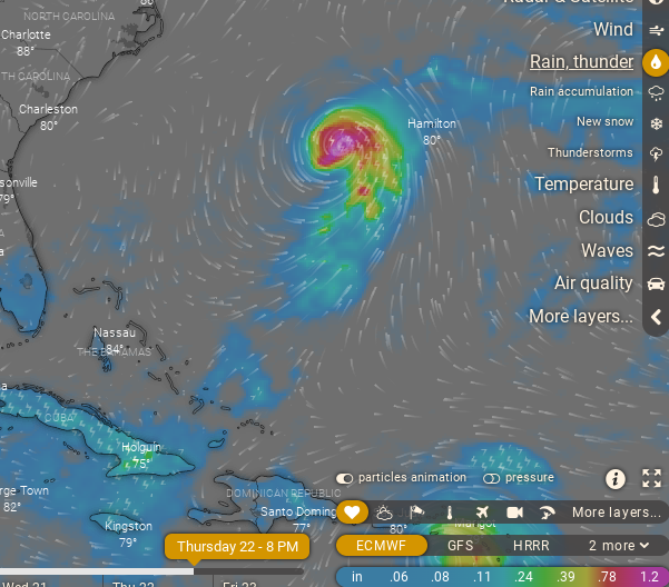
Is this Fiona?
I think so.
Definitely has a look....
... trying to be a TD if you ask me.


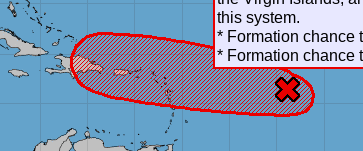
NOTE 70% anytime basically...

Gotta tell you this is the first song that came to mind when watching Invest 96L now a red highlighted circle with 70% chances "any day" of becomming a designated system. Recon should go in by tomorrow and we should know what 96L has under the hood.
Great song but really less about DNA and more about where this storm is going to go? Does it want to follow tracks more consistent with CLIMO does it strike out on it's own like an unprepared hiker on the Appalachian Trail? We all discuss this concept but Dabuh coined it "fork in the road" though think Robert Frost might want to claim that title, but not in the mood to squabble this morning. Actually dancing a bit as I type (honest) so let's talk models the way we will talk turkey in a month or so..

This is the GFS...
...sees your typical OBX storm.
Threatens SC but heads for NC...
Euro lets it escape.
Usuaully GFS sees stronger fronts.
2022 be all cray cray in the tropics.......

The ICON takes Fiona into the Caribbean.
Who do you believe?
If there was a Dabuh model.....
... it'd be laughing at the ICON.

And to be honest I agree with him at least in the short term.
Not ready to say what I think on long term.
But short term is kind of set in stone.

Note the divergence of of wind flow...
96L is a bit too far North for me to believe...
...it'll be a Caribbean monster.
More likely Westbound.
Intensifies enough to feel the pull to the right.
But shear keeps it from exploding.

Water Vapor shows the future track well.
It's not an easy ride....
...but it's gotten this far.
Upper Level Low near Bahamas/Florida.
WNW track probable.
But would like some recon in there.
Intensity forecasts a crap shoot until there's a defined center.
Where will the NHC place the center.
Lord I'd love to read some good discussion on this...
.. wanna be TD.
Fighting to hang on... 2022 written all over it!

strong signature....

Stay tuned...
...time will tell.
I'll update later ...
Besos BobbiStorm
@bobbistorm on Twitter and Instagram
Twitter usually weather and Instagram whatever..
Song up at the top... remember??
posted by BobbiStorm @ 5:32 AM
![]()


0 Comments:
Post a Comment
<< Home