LA NINA - NOT YOUR MOMMA'S LA NINA - No Tropical Development Expected Anytime Soon - Did the Volanco Blow the Forecast Expectations Off the Maps? FRONTS ALL SUMMER. CARIB & GOM BEEN QUIET. MDR Can't Get Find It's MOJO ...
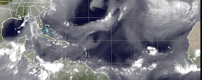
Moist everywhere but...
...where you'd expect it to be.
The dark color in the middle of the Atlantic is showing how dry it really is out there at the peak of the Hurricane Season. No Hurricanes are forming, intensifying or even trying to form. Earl, was that one huge wave that refused to let the dream of a busy season go. It's not the SAL, as the SAL always shows up in July and shuts down the Atlantic until it comes alive in late August and September. There has been barely any activity or even yellow circles in the Caribbean nor the Gulf of Mexico. The little bit of moisture that is in the Atlantic is from the last wave that models spun up into a Hurricane and then dropped faster than a hot potato! The new wave leaving Africa doesn't quite look ready for prime time and this is the best of the bunch of late, so it's hard for me to see anything forming in the distant Atlantic.
There's always a chance one wave makes it to the part of the world where many a weak wave has gotten before it blew up quick in the Bahamas or off of Florida and became a hurricane to reckon with...
Do not end a sentence with a preposition is a rule in grammar. Yet, that rule is broken often and I broke it above.
The models do their best with the data they have to provide us with clues as to tropical development. The models this year have been mosty dismal. A few times they hit their mark, but mostly they will be remembered for the hurricanes they produced that never appeared and the busy, intense hurricane season that did not happen. Yes, we did get some ACE from Danielle and Earl but this was not the promise of all the sites that forecast hurricane season activity. We are way below the mark and this will continue for some time. It is possible though early Noreasters during the Hurricane Season may provide their own accumulated energy, but not really what we were expecting.
I have been screaming FRONTS nonstop since this odd season began, as they never really left the weather maps. Florida has had more fronts approach them this summer than they usually get in the late Autumn. Except for a horrifically hot JULY we have had fronts in the Carolinas frequently.
Models show a possibility of something forming close in off the Carolina coast that would travel up along the coast, messing up the beaches along the way later in the week and that option is on the table as fronts hang there as well as tropical moisture pumping up it's way into Florida, Georgia and the Carolinas all week.
EPAC Season was where it was at and while they were busy there were few eye candy hurricanes.


If anyone wants to make fun of discussion on the Tonga Volcano than that's their opinion but huge volcanic explosions have been known to impact weather and there have been few on record as strong as that one. We tracked the vapor, we talked on it and yet somehow it got missed in model forecasts.
LA NINA suddenly became a thing, a triple dip La Nina adding to all the other green for go reasons the Hurricane Season would be memorable, but it became memorable in it's own odd 2022 way. The Caribbean and Gulf of Mexico behaved as if we were still in El Nino and the EPAC on steroids for a while showed off as if we were having an El Nino, and yet it appears it's a La Nina of an unusual kind. As I told Mike this morning, "Not Your Momma's La Nina!" and that's about as honest as I can get.

Fronts.
It's been the Summer of Fronts.
Now it's Fall Fronts.
Nothing on any model for anytime soon.
And, to be honest the long term models are quiet as well.

Prime Time.
Peak of the Season.
Nothing forming in 48 hours.
There's a little yellow X at 20% off Africa.
Oh how it's early expectations have been lowered.
So what do I think?
I think it's very likely that we will have a few more named storms, probably forming close in somewhere. Perhaps some wrong way hurricane doing odd acrobatics in late Fall. Another storm somewhere and when I mean "storm" I mean a storm to pay attention to vs "OH WOW LOOK AT THE GFS 18Z!"
Lowering my expectations with waves and expecting closer in development somewhere. Wishing on a cold, snowy winter as July gave me enough hot weather for another year at least!
Don't throw in the towel regarding the hurricane season, don't eat the twinkies and go on with your normal life and check in and out regularly to see if something pops up close in as Mike likes to say "Homegrown" along some stalled frontal boundary.
If nothing forms in the Caribbean this year... blame it on the Volcano! That's my thought this morning.
Sweet Tropical Dreams,
BobbiStorm
@bobbistorm on Twitter and Instagram
Twitter mostly weather and Instagram whatever or wherever I'm traveling.
posted by BobbiStorm @ 4:57 AM
![]()


0 Comments:
Post a Comment
<< Home