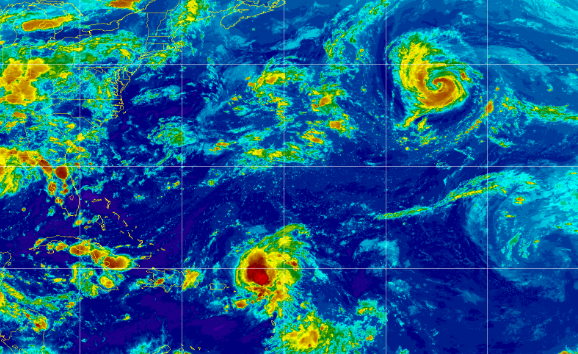
Tropical Storm Earl Forms... Forecast by NHC to be a Hurricane. Danielle dancing with the fish...... Memories of Donna
Tropical Storm Earl.
Earl may be a weak tropical storm, but it steals the show when you look at the satellite imagery for the Atlantic. Danielle is up there, not threatening anything now and not going to really cover it. It's fun to watch but Earl could impact Bermuda depending on where it goes, hopefully Danielle will steer it away from Bermuda. Too soon to tell for a system that has been surprisingly stubborn and has fought off shear and actually intensified a drop with better presentation despite the strong shear that is there.
I won't belabor the point that I knew 91L was not going to fade away. I knew it would get a name and I knew that a system that keeps going despite shear when many other tropical waves would just fade away, needs to be watched because at some point it will hit a sweet spot that allows it to intensify just enough. I wrote about it on Twitter and in this blog numerous times. Will see what really happens.
One problem that could complicate matters and models is currently forecast by the NHC to move extremely slow for days, as seen in the graphic below. As always when a system such as 91L moves slowly it can miss it's ride out of town. I'm not saying this will happen, I'm just saying as always timing is everything with regard to models verifying. So let it spin for now, but don't forget it's there despite shear. Note once it's East of Miami it is forecast to be a Hurricane and pick up speed and skedaddle out of there. Time will tell...
Earl, forecast to be a Hurricane.
Follows Danielle into the N Atlantic.
This graphic from the NHC shows the story.
Shows it better than the models.
I'll update a bit more later tonight ..
...just wanted to say Earl is here.
Earl wasn't early, but better late than never ;)
So from 9 PM... it's later.
This is an OLD article from up August 30th.
Just because a system struggles...
..in what has been an unfriendly ocean.
Does not mean it won't amount to anything.
The Atlantic Ocean, especially the Main Development Region aka MDR, that usually is ready in late August to support development has been extremely unfriendly, unprepared and not interested in supporting much development. Yes, Saharan Dust is there but it's often there in August and it allows even short term development before running out of gas about where 91L decided to develop. Articles such as the one above are correct, but they are meant to grab someone's attention in a slow season that has produced little ACE and not much attention. Yes, it did struggle to organize as it was a large wave with mutliple centers, but eventually large waves are most likely to stay in the game until one center takes over and are more able to fight off shear and SAL as Earl has done.
Earl may follow Danielle out to sea quietly. Few Earls in tropical weather history have ever done anything quietly or boring and Earl may add to the ongoing lists of such storms. It's moved so slow it's hard for me to go back through my blogs and see where and when it came off of Africa. I feel as if we have followed this wave all August, but time hangs slow in a slow season so just know it's there. Let the NHC do their thing and watch the models do their thing and always stay prepared for a surprise during Hurricane Season.
Enjoy Labor Day!
No 1935 Labor Day Storm (thank God) and no Hurricane Donna getting ready to hit as many cities as it can on a holiday vacation. Better to be watching 91L aka Earl and Danielle than to watch a wave come off Africa spinning, taking down an airplane killing 63 people before it barely hit the water and traverse the Atlantic as a Hurricane before zig zagging it's way across Florida and hitting many of our favorite hurricane ports of Call all the way to Canada.
Besos BobbiStorm
@bobbistorm on Twitter and Instagram.
Twitter usually weather.
Instagram whatever ...
Great video really... old school history.
https://www.youtube.com/watch?v=pdDgbJSSuEQ


0 Comments:
Post a Comment
<< Home