TD 8 Forms in Open Atlantic - #98L in Carib - Fiona Major Hurricane - Models Agree on Next Hurricane... Low Rider Wave Rides into Carib & Moves UP into GOM Aims Towards ?? Florida/Alabama Line?
11 AM

3 areas being watched today
Cat 3 Fiona in the Bahamas.
Top right TD8
Low rider Invest 98L
SPECIAL Tropical Statement at 11 AM..
NHC upped 98L to RED 70% just now...

70% in the 5 day and 40% in the 2 day.


short term models above...
TD8 in Open Atlantic at 11 AM.

Out to sea.
But may get the name Gaston.
Or not...


In the Bahamas towards Bermuda and up to Canada

Invest 98L near Carib forecast to go into GOM
Getting busy round here...
....theres even a wave off of Africa.
The big news is officially we have TD 8. Major Hurricane Fiona in the Bahamas battering Turks in the eyewall of the Cat 3 hurricane! Another wave off of Africa. Invest 98L forecast to head towards Florida (or parts nearby) next week as a hurricane. Is this busy enough for you yet? If not, there is no pleasing you!

This area is now TD8

Cat 3 Fiona OVER Turks!

Cat 3 Fiona a Major Hurricane.
Has a bit of shear on the West side as you can see.
Could go Cat 4 if it fights off the shear.
It's doing an eye wall replacement cycle it seems.

Models trending more to the right this morning.
Florida definitely needs to watch this.
Though Cuba will get slammed before Florida.
And this could ride up the East Coast!
IF it crosses Florida further to the N ....
...it could cross over and impact GA and SC/NC
So many questions..
So many storms.
So many names in play.

A picture is worth a thousand words.

If you live in Florida or the SE or GOM
Do not assume the hurricane season is done.
I wrote the blog earlier this morning around 8 AM and since then the EURO has come closer in line to the GFS train of thought and brings whatever the name of Invest #98Lwill be to Florida, crosses Florida but the EURO is still slower than the speedy GFS.

EURO is above.
Hurricane Gaston or Hermine or ???
Invest 98L for now...
Euro in agreement with GFS below.
Same Day.

Both of these scenarios would be huge rainmakers...
...up the coastline not just in Florida.

I am in Charlotte....
...looking for clothes, presents for kids.
Enjoying the Charlotte vibe while my husband works
Used to send these pics to my best friend Sharon who passed away recently, she loved to know what I was wearing and what I was doing so we would basically communicated in pictures as opposed to talking nonstop on old phones with 75 foot cords that for some reason ;) always broke when we were raising our kids. She tracked hurricanes with me, rode out hurricanes with me and we storm chased tropical storms and lines of wild thunderstoms in our spare time while raising our kids. So sharing it with you know. It basically says "okay I made it to the Mall... now what?" and today I am going to kill some time near my husband's office vs walk around a mall that is close to 2 miles of walking if you don't count walking around IN the store so let's say I walked off lunch yesterday! Wish I could hear her thoughts on Invest 98L, she disliked these sort of tracks that never seemed to align the worst weather with a sheared center such as Irene in 1999 that dumped tons of rain on the Miami area. Can you imagine 20 inches of rain today in Miami, cars would literally float off into Biscayne Bay....

So today I will be obsessing more on Invest 98L TD8 Fiona and the wave off of Africa that could, but probably won't, steal the name from 98L that takes a while to form before zooming up towards the diving cold front IF the models that agree sniffed that solution out properly. NHC was eager enough to update their 2 PM product to 11 AM so perhaps its going to get some special attention from the NHC as it moves closer to the Islands. Again, the models have it moving FAST at what would be the end of a 5 day cone and speedy storms can be tricky and difficult to warn people properly.
The main point here to make is this.................stay prepared, check out your hurricane supplies and refill if you or the kids or roommate ate all your favorite goodies you stashed away and ate after deciding the 2022 Hurricane Season is a bust ---- you were wrong. It is not over and until we move through October and until Cold Fronts are all the rage we will have storm formation and possibly inconsistent steering curents. Check your meds and if you need to evacuate from the Florida Keys or a low lying area on the Florida West coast... be sure you are sure where you are going to go. And, as always something could change and all the hyped solutions could slip slide away but once a storm gets into the Gulf of Mexico it's landlocked and someone will get it and if you are lucky shear will show up and keep the intensity at bay. This happens especially when a storm is set to merge with a front and the shear out ahead of the front sometimes keeps the storm from getting too strong. And, sometimes it worst case scenario happens. Truth. But, hopefully not.
Yesterday someone accused Mike of hyping because he merely mentioned that models were looking at possible development down the road in the Caribbean, today everyone has a MEME and if you have not posted one yet you must not be a tropical weather person! Easy to make fun when they have not formed and you are not in the cone directly and Tampa could be... or Tallahassee or Key West well... stay tuned.

Chow for now because I'll be back later...
Updating on Twitter and Instagram as @bobbistorm easier for me to do from my phone.
Out and about and then on the road later.
Rest of blog is from this morning at 9 AM... keep reading if you did not and also compare and contrast how the more recent model run came more into alignment with a threat to Florida and less a threat to the NE GOM coastline BUT remember models flip and we have not even begun flip flopping. But note how the Tropical Weather Outlook changed since 8 AM....a TD and a special tropical update at 11 to hike Invest 98L to RED status rather than waiting to 2 PM. Seems NHC has plans for Invest 98L possibly Hermine IF TD8 becomes Gaston but the way things are going today it's anyone's guess! Below is an orange X for the 2 day but it's 70% in the 5 day as seen earlier in the blog!

$$$$
8 AM Tuesday.

Major Hurricane Fiona...
...in Bahamas.
Low rider 10% in 2 days a problem.
60% Orange a maybe but fish storm
There's unusual early agreement by both EURO and GFS on the low rider (yellow x above) cruising into the Caribbean and moving up towards either the Yucatan or Havana area of Cuba and then aiming at the Eastern part of GOM say from Alabama to Florida tho I would not rule out further West if it misses the front, the next front. So when I woke up to check up on Fiona at 5 AM when my husband's alarm went off I never went back to sleep after seeing the 2nd set of runs that agree. Not sure which is more surprising, that we might have a hurricane in the Eastern GOM (too close to the Florida Keys for me) or that GFS and EURO agree on a 2nd run but I'm up listening to Country songs and updating the blog.

The question is ...which storm is Gaston?
Will the orange x form or fade away?
Gaston is the next name.
And.........Hermine is the name after that!
And could models stay in agreement?
Either way it's logical that the wave sneaks in low.
Crawls along low.
Finds a sweet spot and forms.
Again what happens in the EPAC is a question.
They are practically on the Z storm.
When EPAC has storms they often shear the Carib.
Just reminding you...
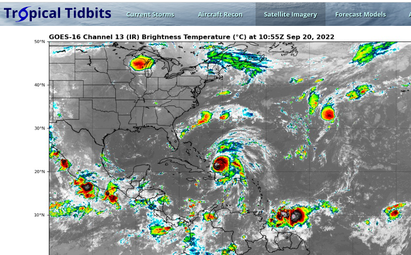
Major Hurricane Fiona center stage.
Down below to the right.... could be Gaston.
Unless Gaston is that bright ball in the upper right corner.
Thanks to Tropical Tidbits for his loops and models!
There is a question on how strong the fronts will be.
Timing... does it miss the front and get left behind?
We have had fronts all summer...
...now they are actual cold fronts.
As we move into October.
E GOM and Florida are our focus!
Or Deep Carib (Mitch, Matthew)...

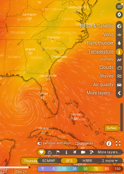
I'm on the road today. My husband has clients in Charlotte to see so hes working and I'm hanging out doing my thing which means window shopping, sipping Sweet Tea (the wine of the South) and looking for a few presents for some new grandbabies I owe presents to and a bit of shopping for Rosh Hashonnah as Charlotte has more kosher food options than Raleigh but I am not complaining I love Raleigh but love the city you are in right? I take the Chromebook on the road usually...so this is a screen shot of all the models I looked at and saved to check on later to see if any verified!
Understand this is LONG RANGE but one reason I am showing it now is that I'm concerned with the current forecast forward speed if this next hurricane really ramps up and moves that fast if it catches the colder of the fronts that dips down, grabs it and pulls it towards landfall. Again, in September fronts grab the hurricane and take it out to sea, closer to October they pull it up out of the Caribbean or Gulf of Mexico and drag it towards landfall. So as we move closer to October we have to keep that in mind and toss out the "I am sure the hurricane season is over, such a dud" line in our head and remember storms like Hurricane Michael or Matthew just to name two! And, depending on the orientation of the front it could drag it up across Georgia and the Carolinas so this is a complex set up.
Expect changes in the models, disagreement and model wars but for now they agree again on back to back runs. Changes are shown below but again take them with a lot of sea salt and know its too soon to pinpoint the details and devil is always in the details!

Euro threads the Yucatan Passage.
Deja Vu of Fiona in the Mona Passage...
The GFS pulls to the right towards Havana.
See GFS below.

posted by BobbiStorm @ 8:29 AM
![]()


0 Comments:
Post a Comment
<< Home