UPDATED Sunday 6 PM. The Problem with Ian... Looks Weak BUT Forecast to be a Major Hurricane. Inland Impacts Thru Carolinas Possibly NJ NY Depending on Track. I'll Be Offline Monday and Tuesday Til After Sunday. Jewish New Year. Stay Safe, Stay Informed on any Changes From NHC

5 PM Ian's track so far.
Where we are today.

I really think we are on the verge of pulling it together.

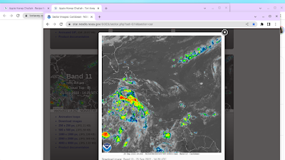
It may not look like much.....
... but I see an improvement.
Looks better than Fiona did...
...and look how strong Fiona ended up.

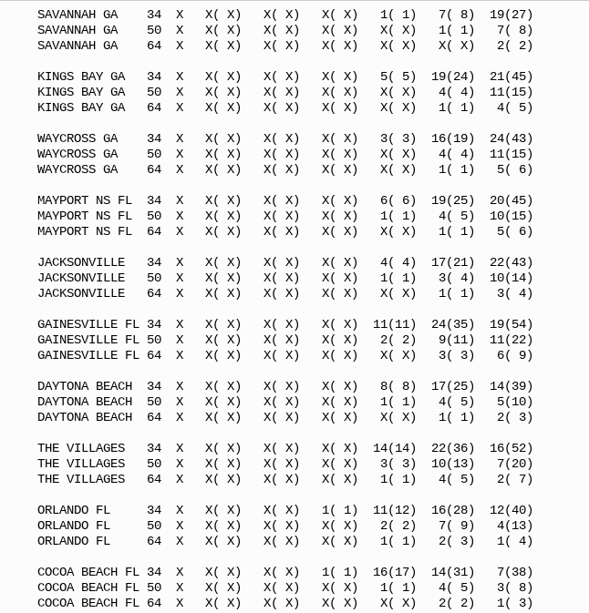
The image above corresponds with wind probs.
The link to wind probs is below.
The shaded area is "wind probs"
The circles are tropical storm force winds...
Inner circle Hurricane Winds.
It's a good map with lots of detail.

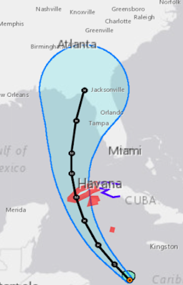
Iconic cone above.
Hasn't changed much.
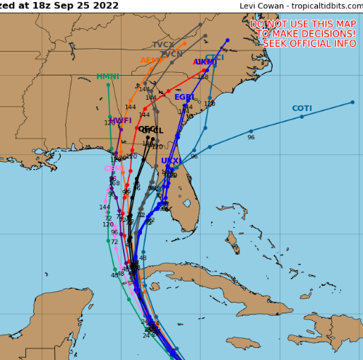
So why do the models disagree?

They don't disagree that much.
Shaded track is ensemble models.
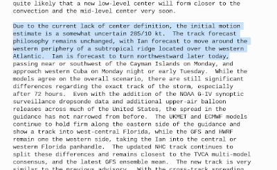
The GFS sees certain things and prioritizes those things differently than the EURO and the other models. One sees a stronger front and a strong hurricane, the other sees a weaker stalled out front and a strong hurricane moving to the North. In September hurricanes are less likely to hook right as they would in October. Later in October, as in the 1921 Tampa Hurricane, it's more likely for a hurricane to catch a front and ride it out to sea. The track below shows you that but this is the last week in September NOT late October, tho in any given year our pattern could reflect that sort of track.

Think Wilma not Ian.
For arguement's sake let's pretend Ian is that hurricane and as you see the dots down by where Ian is currently are green (weak) very green, slowly moving along then yellow... nothing much to worry on! But, suddenly this soon to be infamous hurricane hits a sweet spot, hot spot and shear is low and it intensifies moving along steadily sniffing out a track out of the Caribbean towards Florida. It ends up being the Historic Tampa Bay hurricane from 1921, 101 years ago next month! Could history repeat this year? Maybe. But only if the conditions are right and the cold front is still a cold front not a decaying front further to the North.
There were no models to disagree in 1921 and there were no satellites and there was no NHC to warn people in it's path, just the weather bureau trying it's hardest to warn a population new to the State of Florida back in the early part of the Roaring 20s that a tropical cyclone of some unkown intensity was on it's way to make landfall.
Really?
I'm pretty sure it's not worth the energy to complain that the NHC is trying hard to warn you that the models show a Major Hurricane in the Gulf of Mexico that could make landfall anywhere from Tampa to Pensacola, while it's most likely within the Cone the NHC puts out every six hours updating as needed.
If this does not play out that way and because of dry air and interference from the Upper Level Low that wasn't given enough creedence while worrying on HOT WATER and low shear changed the forecast (or for any other reason best seen in the rear view mirror) then thank your lucky stars and rejoice.
Check with your local NWS often and check with your local experts on line or on air and check the NHC new advisory ever 6 hours. It is that easy...... seriously.
I'll be offline until Tuesday evening when I'll be back.
As always no one will cover this as well as Mike considering he lives in West Florida near Tampa, this is literally his backyard.
www.spaghettimodels.com Follow him on YouTube or Facebook but follow him!
As for Ian, perhaps he will reform closer to the stronger convection or do some sort of jump. When Harvey came together he had strange maneuevers and people doubted the model forecast and in the end he did those strange movements the models did. Models disagree for a reason and there is a reason the NHC uses many models not just the Euro and the GFS.
Have a good year! Have a good week! Stay safe! Err on the side of caution and stay informed of the storm. If and when ... humor.. when the barometric pressure falls below 1000mb we will know something solid is finally happening. But you didn't watch the 1921 Tampa hurricane in real time and if you did you'd probably be wondering if it was ever going to intensify or just stay weak; spoiler alert it intensified and being an October storm it hooked in to the right and made a historic attack on the Tampa Bay area. They have been extremely lucky for a reason.
I'm telling you I am looking at loops and something is beginning to happen. But I'm also telling you something is off still with timing so expect surprises and in this case it may be later than sooner. Maybe. It's South of you................pay attention to NHC every 6 hours!
Sweet Tropical Dreams, BobbiStorm... I'll be back Tuesday Night... please read what I read below it's all still relevant and remember this isn't just about Florida, the wind Probs go far to the North and will keep going further with each advisory this is not just a Florida storm!
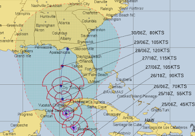
Forecast so far... for intensity is below.

All the way to Virginia 5 PM Sunday Night

* *
`Sunday Noon
Add the Tropical Storm Force Winds on...

This is with the filter for Tropical Storm Force Winds.
See how wide that cone is currently?
At some point NHC will put up watches and warnings.
NRL Cone... Shaded area can have impacts.
I wrote about this on Friday.
Check the link at the end of the blog.
Modles have changed some...
...inland dangers up the road still there.
Purposely wrote long today with information that applies today and tomorrow and the rest of the week as this is not just about Cuba or Florida but Ian can cause flooding and dangerous weather impacts as it moves up into the rest of the country. I'm watching coverage, looping videos friends online have made and baking Raisin Challah and Apple Cakes and Brisket for the Jewish Holidays that begin this evening. I'll be offline after sunset today until Tuesday night so I wrote long today to cover as many bases as I could and to remind you follow NHC, your local NWS and anyone you trust such as Mike from SpaghettiModels who will be updating from the Tampa area where he lives nonstop on Facebook and YouTube.
The Problem with Ian is that currently, despite all the forecasts insisting Ian will be a dangerous Major Hurricane looks weak and it's been a mostly quiet season where storms had problems developing and a lot of disbelief that it could or will really be that bad. Also the issues of timing, there are many cities in the Cone but despite how hard the NHC works doing their job there are many who doubt it and either think they will get worse than the NHC says or nothing. And, I get it as I lived in Hurricane Country most of my life and cones change, hurricanes intensify or get sheared apart. People are all about what they SEE with their OWN eyes. They see a solid ball of red on some satellite imagery and they think "OH MY GOD" but Ian isn't looking so "oh my gosh" this morning and it's hard to convey that you cannot rely on what you see today with what is forecast for 3 days from now.
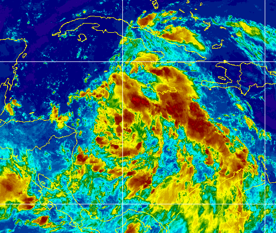 '
'You know what I see from this seemingly unimpressive satellite image? Well, other than a snarky smile you can see it is pulling itself together and has rudimentary bands that will fill up with intense convection and destructive winds down the road. I see what looks to be a NE Quandrant that will most likely be mean and will slap areas far to the East of the actual cone with wicked weather. I'd love to believe otherwise, but this is just the beginnng with Ian. Also if wind shear from the approaching front near Florida appears it will blow that wild weather to the East of the Cone.
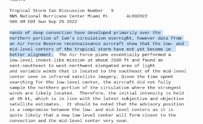
And, I won't lie, this is a dangerous set up as currently it looks crappy, but when I come back online Tuesday Night after the Jewish New Year Holidays it may look formidable and very threatening. I have said before there is more dry air there than being spoken about and it is having problems vertically aligning. You'll remember we just went through this with Tropical Storm Fiona and eventually Fiona did pull it together and went all the way to the most Northern regions of Canada as a Hurricane. Discussion from the NHC above tells the story honestly and you can also tell how hard it is for the NHC to give a "down the road" forecast for a system that barely has a center and the winds are not what they should be currently. Early models, way back when, showed this happening and then they showed it suddenly intensifying. Yes, one model went that a way and another model went the other way BUT THEY BOTH SHOWED A STRONG HURRICANE and they both still do. But as I said last night for Ian to take advantage of that bath tub hot water it needs to be properly aligned vertically.
You can't get much more transparent than the discussion from the NHC above. "Due to the current lack of center definition" that's about as honest as it gets. They also remind you that once it does align and it is forecast to do so it will take advantage of that hot water and low shear environment.

My biggest concern with the forecast for IAN is that this is not just about the center of the Cone and where Ian makes landfall, but that it is very possible that Ian will be sheared after it attains a strong Major Hurricane status the shear weakens it as the front approaches and the severe squalls, storms with wind impacts, tornadoes and flooding will be far removed from the center of the cone. That means Miami, West Palm Beach up to Vero Beach and then later move that up the coast towards Jacksonville as wild weather sheared to the East over the whole state of Florida is a bad, dangerous set up.
Along the center of the Cone where Ian moves towards landfall it will pile up water in the many beautiful low lying areas some natural areas with a low population and others big cities such as Tampa. Whether the ultimate cone is the West or closer to land to the East water gets pushed NORTH up into the bays and inlets that make life on the SW and West Coast of Florida so beautiful.

Do not look at the city names.
Look at the land.
The inlets that run from S to N.
Water will get into those and spread out.
Flooding can happen without a direct hit.
With a direct hit you can get horrific flooding.
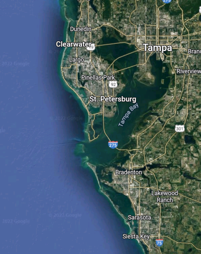
Water funnels into Tampa Bay.
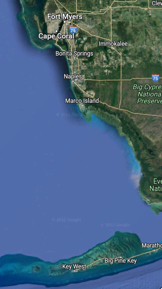
Also down to the South near Naples and North.
This whole area is filled with estuaries.
Bays, canals, marsh and many communities exist.
Florida Keys north to Naples, Marco Island.
Even if it stays offshore the water moves onshore.
5 Day Rain Totals.
And after 5 they move North inland.
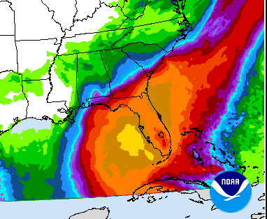
So ALL of Florida can get impacts.
Life threatening impacts.
Even if they are far from the cone.
As I said the other day.
This is not just about Florida.
It has a track that impacts many....
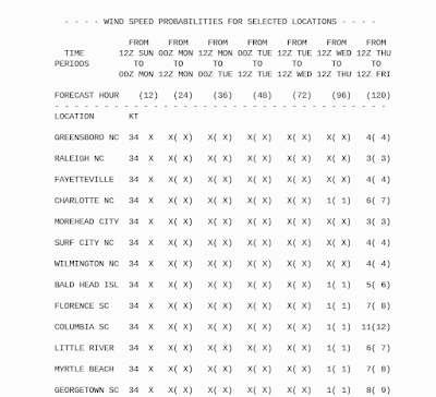
...way up the coast, inland and beaches.
Even I have wind probs inland in Raleigh!
As for the models, this is the bottom line, models change as reality happens and after Ian pulls it together and the front begins to dip and the Upper Level Lows do their thing... it's a dance that is choreographed yet changes are made in real time as dancers seem to improve a bit on stage. Ian is on stage and things will change, they always do and there is always some wrench thrown in be it size, track, intensity or timing.
What do you do?
Old adage I grew up with....if a tropical system is South of you watch it carefully and pay attention!
IF there is a tropical system to the S of you ...no matter what the forecast is you pay attention to it, know it is there and pay attention to the situation should it suddenly change and often even with the best work by the NHC something changes and you need to be able to adjust immediately. Don't write it off and celebrate your good luck until it has passed you by and you are totally safe. IF things change or IF you are in the Cone and it's time to put up the shutters than put up the shutters or go to a house that has shutters. IF you want to go to a shelter make sure you register as apparently you have to register at some shelters and when they are full they are full. This is what you should be doing now.
It's that simple.
IF THERE IS A TROPICAL SYSTEM TO YOUR SOUTH MOVING NORTH YOU PAY ATTENTION EVEN IF YOU ARE NOT CURRENTLY IN THE CONE. If you are suddenly out of the cone but near it KEEP WATCHING and checking in every 6 hours when the NHC upgrades their cone.
I would love to come out of Rosh Hashona and find out that it didn't amount to anything and did some odd dance in the Gulf of Mexico doing loops where upwelling just wore it down like a child's story your parents may or may not have read to you. Don't think that's gonna happen.......I don't rely on miracles but I do pray. And, I suggest all of you know what you need to do so you can put it into action. I've heard it's almost impossible in Tampa Bay area to get a generator today! Yet, will it hit Tampa Bay? Will it come in further North near the Big Bend but push a dome of water into every bay, inlet and river along the way? Will tornadoes be a problem as hurricanes in late September that are catching a cold front often product tornadoes far from the center track of the eye.
Will the cold front be strong enough to grab Ian?
A stronger Ian will want to go North more as major hurricanes seek out the North route, unless a high blocks that or something else catches it and drags it off to the NE suddenly.
Weather is difficult to predict, tropical weather even more so as you need to know the weather up streange where the hurricane is moving and the dynamics inside the particular hurricane seeking out it's particular harbor.
Stay safe.
I will update later but I am busy today so I'll be online less and wrote long this morning. I'll be on Twitter all day. I'll update the blog after 5 PM advisory.
www.spaghettmodels.com has all the links and information you need. Know he is also directly in the Tampa area, his home is one a cute little lake and over time the few times a major hurricane hit his area Oldsmar did flood so no one will be as on this as him even if it moves away and he hits the road to chase.
@hurricanetrack Mark Sudduth is good, follow him.
https://twitter.com/DaDaBuh is good and entertaining.
Find your favorite local people and follow them.
Stay safe... Err on the side of caution and if things change and you're out of the cone or Ian doens't live up to it's great expectations say "thank you" and take down the shutters, give thanks, party.
But until then..........pay attention to it as if your life depends on it.
And, hopefully you will be safe and it would be nice to believe Ian will be a bust but the models did well with Fiona despite a lackluster appearance and we know how she turned out.
http://hurricaneharbor.blogspot.com/2022/09/everyone-focues-on-landfall-but-this.html Friday's blog warning of possible flooding dangers far inland up the coast. The models have changed but the dangers are just stronger in other places especially Georgia and the Carolinas and up the coast.
Besos Bobbistorm
@bobbistorm on Twitter and Instagram
Twitter mostly weather and Instagram whenever I get around to it.
I'll be offline from tonight at sundown until Tuesday evening sundown in Raleigh NC.
Kind of like Sandy Koufax who didn't pitch in the World Series on Yom Kippur.
World Series and Hurricane Season always hit at the same time as the High Holidays.
But I'll be on Tuesday Night and this is far from over as it could impact a large part of the Eastern Seaboard and they too should be wondering what happens after landfall the way Ida rampaged her way through NY and NY. IF it's South of you... monitor it.
Once Ian wakes up we will be sorry it did I think...
posted by BobbiStorm @ 8:49 AM
![]()


0 Comments:
Post a Comment
<< Home