Update 11 PM........Cone Moved a Bit... IAN Moving NNE.. Tornado Warnings Across FL MIAMI FLL KEYS SW FLORIDA ..OUT AHEAD OF THE EYE. Stay ALERT Tonight!
From the Interactive Cone at NHC page.
After touring the Dry Tortugas (as per the NHC headline) earlier the cone was shifted a bit to the right (E or SE depending on your perspective) and now goes over Cape Coral vs Tampa directly, though Tampa is in the cone. Hurricanes such as this one that went through an eye wall replacement cycle just prior to the release of the 11 PM advisory are tricky and could be a Cat 4 at 2 AM at the update and then we will see what tuning the NHC does to the cone at 5 AM. There's a wild Major Hurricane moving towards landfall with weather outside the eye that will impact the entire state of Florida as a front moves down but being late September does not sweep down to Cuba so what Ian does EXACTLY is very hard to forecast. Also a strong major Hurrcane carries a high aloft and can sometimes make it's own weather or get a vote in it's exact track. A Cat 1 or Cat 2 is easier to forecast but once you are knocking on Category 4 door... things can get tricky. It may take a jagged track across Florida rather than a straight beeline one on I-4.
Up close and personal on the interactive map.
Compare and contrast at 5 AM!
Cone of the hour!
Does Ian go stationary.
Does IAN stall a bit?
Or crawl along on it's creepy way?
Does it surprise us and pick up speed?
So my main message tonight is where ever you are you are, now is not the time to hit the road. If you left, stay safe and have patience. If you did not leave hoping it would jog North or South away from you ...you are where you are hunker down.
1. Let your family and close friends know where you are exactly on the road or at home.
2. Keep your phone battery totally charged .. PLUGGED IN NONSTOP.
This is important. You meant to but you go make a snack, Aunt Martha calls 30 minutes later u forgot
then u call your cousin to let them know and your phone is at 40% as you had to Facetime Uncle Bob.
3. Keep the phone plugged in, fully charged & tell relatives you can only text.
4. Keep your weather radio or radio & batteries nearby.
5. Good to have a local News App but stay off the phone as much as possible.
6. You may lose power and this can be a long ordeal as Ian is forecast to slow down.
7. Pace yourself, have patience.
8. Hope you bought crayons for the children.
9. Use the crayons yourself if you get nervous.
Seriously..........hunker down and stay safe and stay home.
New advisory package at 5 AM
Personally I have friends in the path of the current cone who yes stayed vs evacuating for whatever reason they had personally and concerned about them but they are hurricacne savy. I know chasers in the track of IAN and though I do love to chase hurricanes, tropical storms and wild weather I don't take on Major Hurricanes unless they find me at my own house and that's happened a few times.
I'm looking at the Northern end of the Cone to see how close Ian gets to where I am in North Carolina.
It is what it is but the one thing I can promise you is that something else will be thrown into the mix.
Originally it was moving FAST day 3 to 4 to 5. Yeah, I knew that wasn't going to happen in late September with a Major Hurricane moving towards a "cold" front. Ian will ride the frontal boundary it's that simple but then what?
If this was late October this might have been a Miami storm.
Stay safe, get lots of sleep if you are reading this tonight.
Pay attn to any changes at 5 AM.
This is NOT just about Florida.
Where does it go down the road?
GFS www.windy.com
or EURO
Stay tuned.
Stay safe!
* * *
My blog tonight is about the weather currently.
Tornado Warnings Across Florida allevening.
Far from the EYE of Ian.
Dangerous life threatening weather is happening NOW!
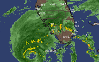
These bands swirling around the eye, training in (meaning new cells form and trace the same path of the previous cell) all evening in Southeast Florida and then moving up the Florida East Coast. Note the reddish color in those bands shows the intensity and tornadoes spin up. I have kids who live in Hollywood Florida they can confirm there is debris across may road ways and not just palm fronds. They saw trees down, debris signs of a probable tornado that has been reported touching down by trained spotters. Myconcern is people running around nervously tonight to get last minute supplies and they run into debris in the road or someone running into them. People get nervous after a day of nonstop weather and are distracted so you can be a good driver but the person who hits you is not as good. Drive carefully if you must go out. If you have an active tornado warning take the proper precautions. It's sadly common to have people die during a hurricane, before the hurricane from dangerous weather in distant bands in an area you felt "safe" because you are not in the cone the the severe weather and tornadoes are outside the cone. And, with this set up of Major Hurricane now moving NE into the front everything changes fast in real time.
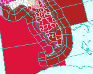
This is the cone to pay attn to...
Wind warnings.
This is not just about the EYE.
The "CONE" is about the EYE
All of the WEATHER is now funneling NE
Towards areas outside the Cone.
IAN at 8 PM is moving NNE
You can see my concern.
Bright pinks far to ENE of IAN
Miami FLL WPB UP the coast as it moves.
So yes prepare for the eye of Ian.
If you live in a low lying area...
..hoping you evacuated.
I have many friends in SW Florida.
But tonight the energy of Ian
Will surprise people who felt "safe" ...
...far from the Cone.
SW FL
Florida Keys
SE Florida
ALL under the gun tonight from IAN
due to severe weather and tornadoes.
I'll update after the 11 PM
More to come.
BobbiStorm
@bobbistorm on Twitter and Instagram
https://www.floridadisaster.org/SheltersTo find a shelter across state of FL


2 Comments:
This comment has been removed by the author.
Thank you for your blog Bobbi! The weather history you share is always very illuminating to present day weather. I always learn something from your blog!
Post a Comment
<< Home