Colorful Convection in the Caribbean... EPAC Begins in 19 Days!
As we cruise into May....
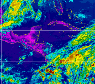
this is where we pay attention.
.gif)
Note the flow over Panana moving from the SW to NE
Also notice the flow moving NE from Mexico over the USA
Feeding the severe storms and chase weather we have ongoing.

Close up a look at this interesting box.
This region encompasses the Deep Caribbean and the Eastern Pacific. If you cut the map vertically, you will see this area as one region and what happens in one area impacts the other. Strong convection is moving off of Colombia which later in the season produces convection frequently that can develop and/or westbound tropical waves move into these juicy waters and make a tropical connection. It's a secondary Inter Tropical Convergence Zone that often feeds storm development in the EPAC. The EPAC Hurricane Season begins on May 15th so this is an area that bears watching. The fly in the ointment as seen below, is currently the flow is still from the SW to the NE meaning it'll blow back convection into our basin. Sometimes a storm forms in the EPAC and crosses over into the Caribbean early in the season. Nothing is expected to happen, but if you're on a cruise down there the weather will be wonderful if you like stormy weather. This region also has many diving locations so it's important to watch it more than you look out into the Atlantic for tropical waves that will battle the Saharan Dust already in place moving off of Africa early this year.
A wild card is the early tropical waves running at low latitudes towards South America, sometimes in busy seasons you get an early one such as Bertha in July, but this is late April and they are just fun to watch. A brillian colorful display of convection on the various satellite images we watch, but remember it's not September nor is it even July! Wind flow will blow that convection apart and/or up towards another part of the Atlantic where water is not hot enough yet to develop.

Stay tuned.
Prepare.
Get a plan.

During Irma's approach to Florida.....
... Miamians found a plan.
Everyone raced North towards Atlanta.
Survivors from that road trip.....
..,most likely will not do that again.
Cars were abandoned.
Gas Stations out of gas.
No Hotel Rooms ....
Just saying, panic is a great motivator.
But better to have a plan than panic!
Sweet Tropical Dreams,
BobbiStorm
@bobbistorm on Twitter
Everybody's got a cousin in Miami....
...come August and Septemeber
Everyone wants to get out of Miami
posted by BobbiStorm @ 11:32 AM
![]()


0 Comments:
Post a Comment
<< Home