AOI off SE Coast Interesting. 95L an Open Wave. Not Talking Yet on African Wave..

This is the first image in a loop.
95L getting so much attention.
Why?
And few talking on how energy shifted in 95L
Northern edge of 95L has more convection.
Northern edge of 95L has more convection.
Despite models focusing on the lower track.

95L is IN the Islands.

Study this image you will see a lot.
What's pulling it.
Convection sheared, normal there in July.
Strong bending convection to the N
tho lead convection went S
It's been a mess last few days.
Yet we still talking on it.
Sometimes they come back to life...
...so we watch.
Not expected to...

I'm more curious on things closer in.
Closer to land, the coast, cities in SE US.
As Levi Cowan says here.
95L is an open wave.

That means it's dead in the water.
Just rain on your wedding day.
Just convection.
Let's move on...
..circle back if something changes.
Let it go...
NHC this morning...
...oh what's that.
So clsoe to the coast?
Let's focus on that!
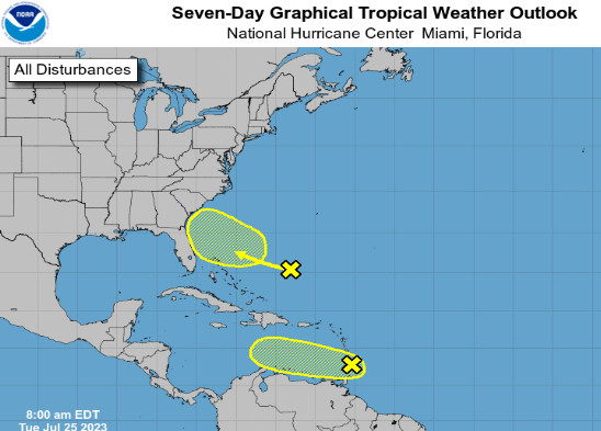
NHC giving 95L next to zero chances.
Close to the coast there's a circle and a X.
X for Twitter huh?
Teasing.
Shaded area is where it could develop.
Go back to the top.
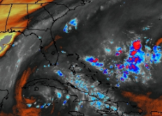
Yesteday no real convection there.
This morning there's convection.

So let me explain.

Bottom left there's a curved red line.
South to N this is an ULL
Upper Level Low

That ULL helped to shear tear apart 95L
They can do that... add shear somewhere.
Shear wannabe tropical systems.
It's all about locaiton.
Being there is bad for 95L
"bad" for development.
Not bad for those worried on development.

Low here to the SW of an AOI is different.
Area of Interest.
The Yellow Circle off the SE
Depending on many things.
That could help ventilate it a bit.
Not inhibit it but help it.
All very iffy.
Why?
Because ULLs move around.
They fade and then come back.
They are incredible to watch in July.
Going wide again....
There's a front... kind of dead front.
Does it really feel cool anywhere there?
Oh it was 69 for a NY minute at 6 AM in NC
By 9 AM it was 85 here.
Fading decaying fronts help development.
Shape of the coast and heat of the Gulfstream.
Often have helped a fast spin up there in July.
There's a reason the NHC put it there and the fact that models aren't huge on it doesn't phase me as models were hot to trot on 95L and the wave before that one too. The water there is hot as every weather person in America will tell you right now and add in the heat and the lay of the Gulfstream and IF anything develops there it could impact our weather along the SE coast from S FL to Carolinas and beyond.
Yeah it's an IF but it's all been an IF because it's July. When I was young and first doing this I'd get excited about any signs of rain/convection aka color on a satellite image and think "it could develop, it could develop" and some older, wiser, boring, annoying met would say to me "Bobbi it's July" and I'd think "it's gonna develop, it could develop...." and they'd bring out their heavy wand of CLIMO in capital letters and I'd think "it could develop" and yeah ...no.......it didn't develop. Okay, Bertha developed, there's always that one or two but in July it takes moe than hot water beneath the convection to get a tropical wave spinning especially when it's swimming in a sea of SAL.

Orange/red/gold SAL
Saharn Dust enemy of tropical waves.
95L is surrounded by SAL.
Coastal Blob being watched....
...is not.
Today it's a blob.
Yesterday it wasn't not.
What will it be tomorrow?
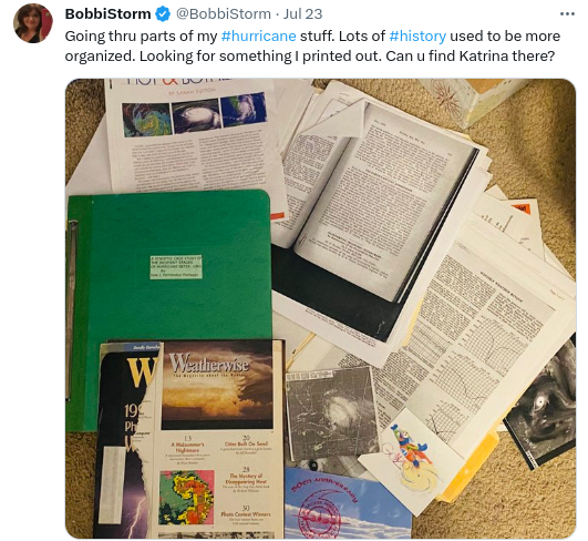
I tweeted this yesteday.
Bottom center black and white sat image.

Took me a minute.
That's Katrina.
Off the SE Coast... before it developed.
I'm NOT saying this is Katrina
or anything like it.
But it developed from a similar set up.
Different but similar.
Years back I did a lot of research at the NHC in the library going through old papers, books, studies and good friends with a few people there. I learned a lot, more than I would in any of the meteorology classes I took in college for my degree in GeoPolitics trust me. My neighbors growing up in Miami were meteorologists who flew into hurricanes and worked at the NHC. One in particular would explain to me as a child what the pictures that lined the wall of his mother's house next door showed other than just a lot of cloud banks. Not all storms form from Tropical Waves. Sometimes an Upper Level Low gets too big for it's britches, gulps in moisture and it gets entrained in it and develops into a tropical storm. Sometimes a mid level trough off of SFL in conjunction with other moisture from a nearby weak tropical wave and general atmospheric conditions spins up into a Hurricane as Katrina did tho Katrina was the exception most slide up along the Gulfstream like a child with a box of candy not leaving until he' got all the sugar he could get ... Gulfstream can be like steroids and a blob can pull together fast especially between N FL and Georgia in the Georiga Bight an area that's somewhat shelted.
So with all this talk you want to know where it can go?
It can stay there undeveloped and rain which would be good for Florida as the high, record temperatures would come down. It could up the ante for showers along the Florida coast even crossing Florida just a little bit and making rain fall everywhere. Rain is good unless it's floods because it brings down the crazy temperatures. One reason for the high record temperatures every day in Florida is there have been barely any afternoon thunderstorms except for isolated cells popping up over my son's concert he went to yesterday in WPB. Daily monsoons help keep the temperatures down and they have been few and far between or you'd see them on the news with associated stories of how South Florida is flooding.
If it develops and pulls up the coast it's anyone's guess because it's currently not an Invest, the models barely see it and the wise forecasters at the NHC have it there as a yellow X (really a question mark) to remind people in the area something might develop and they are watching it. And, that is good.
I'm not going long on the new African Wave yet as ..........it's not the best wave and the models that like it liked the last two and neither developed. Another few weeks they may be more productive but hey we watch it anyway because that's what we do

This is a lack luster African Wave Train
Even for July.
SAL is the white dots in the blue ocean.
Not Yet.
Gotta run..
..got a chiropractor appointment!
I'll proof this and update later.
Sweet tropical dreams.
Stay in the shade.
BobbiStorm
@bobbistorm on Twitter and Intagram
Threads also look me up there.
Say hi.
posted by BobbiStorm @ 7:51 AM
![]()


0 Comments:
Post a Comment
<< Home