TS Don Again... Going Round and Round in Circles. Tropics Quiet... Lots of Rumbling on LONG Range Models.... Very Nasty Environment for Tropical Development Currently. Canadian Smoke Returns, Going Round and Round Still.
Tropical Storm Don!

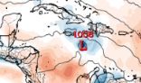
Grid from Spaghetti Models above.
Let's start off with Don.
Tropical Storm Don.
Back again from the almost dead!
Don will be with us in some form or another for a while. Emily is the next storm up. Worth noting in 2017 Emily was a very small Tropical Storm that formed and traveled across Florida as if it was on vacation looking for a theme park. So keep that in mind as the environment for tropical development any time soon is very, very low. Models are sniffing something late in July close to August but what it is isn't exactly clear. And, it doesn't help that every model run shows something different, but again with some similarities. Check out the info on Emily in 2017 below. Formed fast, made landfall, even though it was small there was a million dollars worth of damage and it formed from an old frontal boundary.

Emily in 2017 was a product of something spinning up close to land, over very warm water from an old dying frontal boundary. Similar time frame we are moving towards so worth remembering as history does sometimes repeat.

That blue pearl necklace is Emily's track.
Back to 2023.
An odd year for many reasons.
In 2023 we have areas with extremely hot water that would be high octane fuel IF a tropical cyclone developed in that hot water or traveled to that very hot water. But due to SAL (Saharan Dust) that is sucking all the moisture out of the air in areas of the atmosphere that tropical cyclones need to be moist there has not been much happening out in the MDR that for a few weeks everyone said was very HOT and that meant it would be dangerous for development. Yes and no, no not really as anyone who knows Hurricane or Weather History ...even recent history such as last year... knows hot water alone will not get you a cyclone!

Look at the large Low DON......
...not the lil red L.
Think about it.
Oh look at the squished small High to the East.
Does any of this make sense or seem normal?
No...not really.
And more so the odd models, for example the GFS, showing possible development in the MDR while Don circles around, diving down towards the MDR before lurching back up again doesn't seem to totally inhibit a weak low from forming (according to the GFS) which makes really no sense as it's not a large, huge high because often development forms South of a High Pressure rarely beneath a huge Low Pressure Cyclone and if it did it'd get sucked up into Don giving it new life, energy, like a shot of an energy drink before zooming up again somewhere else Don goes. It makes no sense. When something makes no sense you wait til the next run and wonder what it's smoking. GFS images from Tropical Tidbits.

The above is an image of Don.
Forecast to continue along ...
...going round and round in circles.
Doing strange kinky things to the Atlantic
Messing with the flow, the lows, the highs.
Note the GFS tries hard to ...
...somehow, almost miraculously tries to form a Low.
It takes that Low West towards the islands.
A weak attempted low creeping along

GFS Never. Give up. Hope.
Unravels but somehow comes back.
Lil Low there.... tiny.
Unravels, falls apart, snaps back again.

The lil Low makes it to Texas or TexMex.
Maybe....
Yesterday it slammed Florida with a Hurricane.
Remember that on every run of the GFS.
Hurricanes appear and then they disappear!
Euro shows some moisture moving along.
But nothing as dramatic obviously.
Again this was the GFS this morning.
This afternoon and evening it'll change.

My bottom line here. Do not swear by the moon and do not swear by the models this far out when the atmosphere in the Atlantic is almost bone dry and excellent looking tropical waves can't gain traction or moisture on their way Westbound. At some point SAL lessens and and shear is not as strong and some sort of normal High will be in place and the water vapor will show you that a strong, vigorous tropical wave will look as if it could form and become a named storm and even a hurricane. And do NOT let your guard down because denial is living in illusion and illusion becomes dangerous as we move into the height of the Hurricane Season. From the road... spending the day in Savannah again.... going and coming, yes I know. Did you know I'm actually related to the first Jewish passengers who were on the ship that came to Savannah in 1733 and later settlers... but not directly, shared ancestors and lots of distant cousins. Because I'm old Southern Jewish and I had the best breakfast this morning with the best grits I've had in ages :)
Remember this!
Shakespear knew weather and the planets.
I'll give him credit on that one.
It's not the time or the place for tropical development.
Not yet... but eventually.
There will be a time... a place...
...when a tropical wave can become a Hurricane.
But what's in a name?
And what name will it be?
Stay tuned..........
....coming soon.
But not tomorrow or the day after tomorrow.
Sweet Tropical Dreams,
BobbiStorm
@bobbistorm on Twitter and Instagram... and Threads
Learn from Willy..
Song of the day... remember it.
Don't let your guard down?
Stay alert.
Monitor the tropics.
Pay atten to the NHC
Read my blog ;)
Don't eat the Twinkies from the supplies!!
posted by BobbiStorm @ 8:46 AM
![]()


0 Comments:
Post a Comment
<< Home