Invest 95L at 60% For Development in 7 days. 40% in 2 Days. Don Out There Doing His Thing. What Will Happen? Few Possibilities....

Don and the Invest 95L
Could be Emily one day soon.

Note Don at the top.
Invest 95L looking good.
Actually looks similar in ways...
Maybe that's the shape of 2023?
They are both on the small size.
To the NW of 95L is a Blob.

Nasty smile there.
A bit of a trickster?
Earthnull for 95L
Actually looks good for 40% in 2 days.
It takes a while even under the best of circumstances for a elongated tropical wave to pull together and become a Tropical Depression. Sometimes it looks easy but that's usually deep into August and September when the atmosphere is perfect, primed and ready. We aren't there yet, but we are getting closer every day.

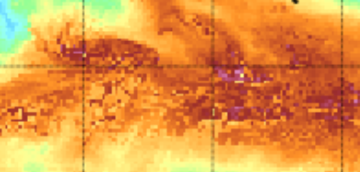
Orange/gold/red is SAL
Saharan Dust.
You can see the white dot that's 95L
Look at it close up....

It's as if 95L wanna be Emily wearing accessoies.
Got a red headband!
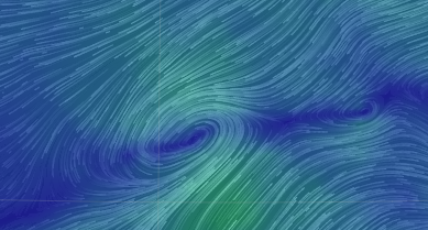
You can see there is a circulation in there...
..as you can see the deep reds of SAL
caught up in the spokes of 95L
Above we see....
To the left is 95L
To the right is the wave behind it.
Note the little white dot on 40 W..
Note the second dot before 30 W.
Mimic shows moisture....
...it shows sometimes more.

You can see 95L
Actually looks better than an orange circle.
Problem is it is fighting SAL and shear will appear.
Models

Westbound models into the Caribbean.

Other models pull it to the WNW or NW with time.
I know this is a set up as old as time... right?
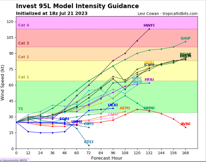
So what is the fly in the ointment here?
Intensity models go high.
Hurricane High.
Then again some stay low....
....as if Emily won't last long.
Which is it?
And, that's the bottom line. Every year is different, every month has it's own positive and negatives. Every week there's a bit stronger shear or SAL or less. Until we get fronts moving, this is what we get also. Fronts up the ante, the pull at a tropical system trying to lift it more to the North. They help sweep a hurricane out to sea or they suck it in towards land as lows go to lows and lows stay away from high pressure. The big strong high is not yet carved in stone in place. It's been an odd year and Don doing Don's thing puts the hold on many other things we normally wait to see.
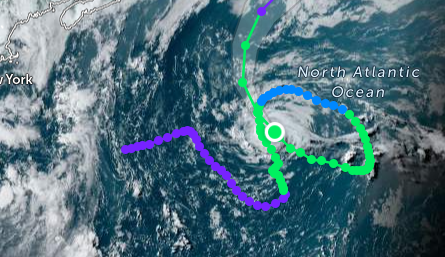
Don doodling circles all over the Atlantic.
If 95L strengthens it will most likely pull WNW IF the High wherever it drops anchor allows it to do so. If it stays weak it's westbound into strong shear and the Islands. I hate to say time will tell but this is one of those times it's all I can say. I wrote the Tweet below earlier in the day it's pretty much the bottom line so leaving it here.

Until SAL thins out.
Until the shear weakens.
Until we have a true verified center.
Never take a model serious until...
...the system has a strong, verified center.
Keep putting together your Hurricane Plan.
Do you need a generator?
Or are you going to evacuate.
If evacuating do you know where?
July is for getting supplies together.
August turns up the dial..
..You never forget September usually.
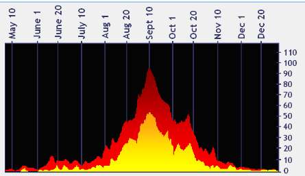
August 1st shows a rise in activity.
We are in line with CLIMO
Prepare, stay aware.
Recon is supposed to go in ... in 3 days.
Still a lot of IFs.
Stay tuned.
Have a great weekend!
Sweet Tropical Dreams,
BobbiStorm
@bobbistorm on Twitter and Instagram...
...and Threads.
Ps Stay hydrated but have fun this weekend.
It's summer.
As for Invest 95L ....
..we are all along for the ride.
Ps....
posted by BobbiStorm @ 2:03 PM
![]()


0 Comments:
Post a Comment
<< Home