A writer and a tropical muse. A funky Lubavitcher who enjoys watching the weather, hurricanes, listening to music while enjoying life with a sense of humor and trying to make sense of it all!
Wednesday, June 12, 2019
UPDATED THURSDAY!! Tropical Waves Coming Off Africa... Flooding Summer Rain Closer to Home. Could Anything Develop? Officially NHC Says No But Lot's to Watch.
Publix has a lot of good buy one get one free specials today.
Juices. Baby Wipes.
Things you will need during hurricane season.
With strong waves such as these above...
...and stalled out fronts near North Florida....
You should be shopping now!
Making lists.
What do you need to do if a hurricane comes your way?
Or pops up off shore from a dead cold front?
I'll update later today about record heat and rain...
...and why this should concern you.
ciao for now...
be back later.
Please read if you have not done so already.
Thanks!
Today's post is regarding waves over Africa.
And much action close in that I'll discuss later.
There has been much discussion on early African Waves.
You can see our latest pair coming off today.
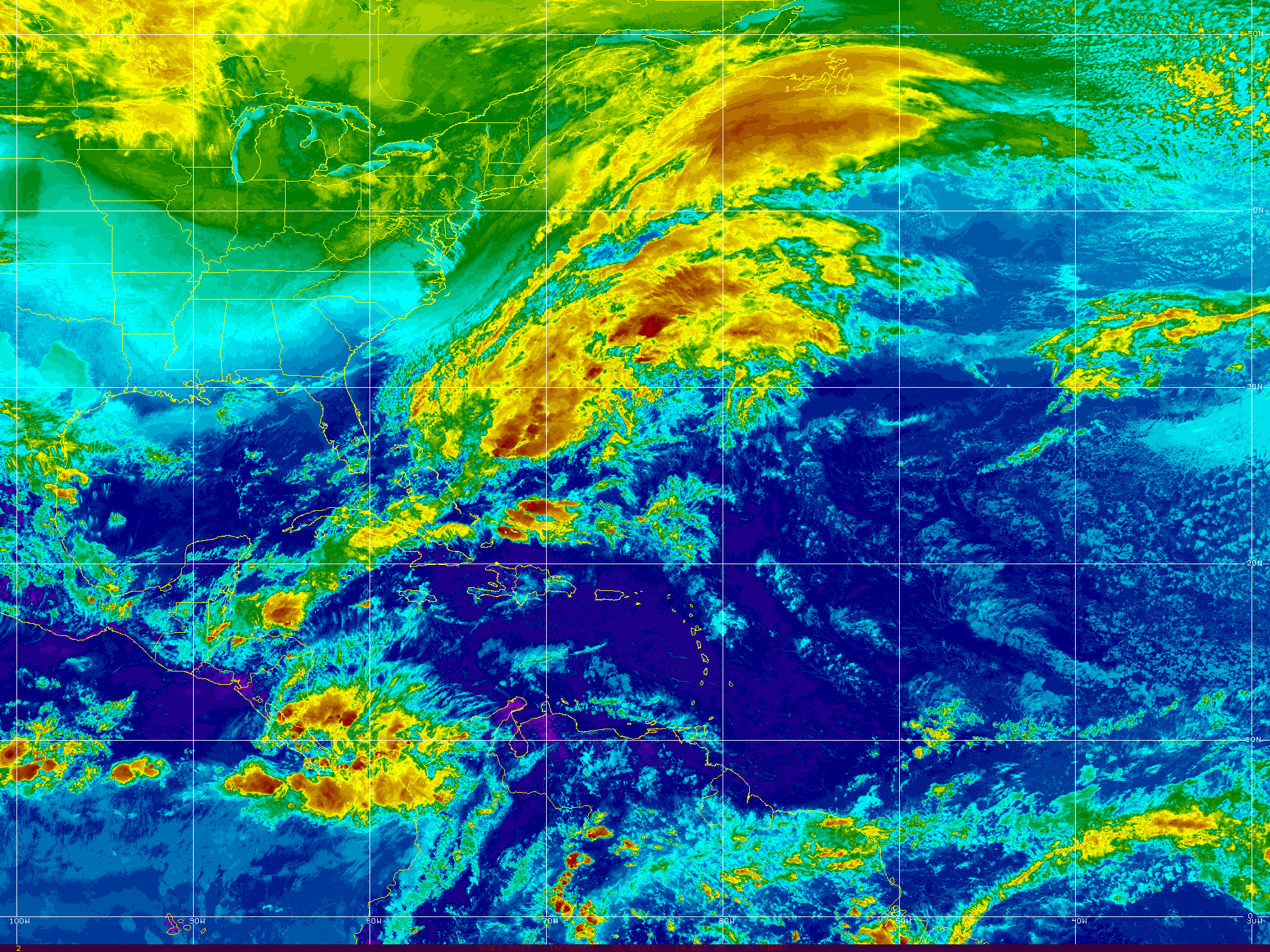
There is African Dust known as SAL to the North.
A huge high more discernible on Water Vapor Imagery.
What you also see in the above image is the shear from the Caribbean...
East bound towards the Atlantic.
So if there is shear and there's SAL why are we watching the wave?
Honestly it's a kick ass wave for any time of year.
And though it's too soon in June this June has felt more like Mid July.
It's not totally impossible for a wave to find a way to stay together.
It happens.
It happens rarely.
I was asked online if it's a a "frightening glimpse of things September has in store?" from a good writer and a long time online friend. I'd agree except that this June has been like July in many ways so I'd say it's a glimpse of what August may bring. Yes, we do exaggerate early waves (his words) but my response is two fold.
There is always some wrench that crops up in the tropics regarding what seems to be perfect, positive conditions for tropical development. This time of year we have shear coming out of the entrance to the Caribbean that blows apart kick ass waves. We have a strong high that sometimes propels them too fast yet this year they have made it across the Atlantic and washed up onto the shores of South America still noticeably held together enough to have been able to track a wave's progress the whole trip from Africa. This is something we do and something we enjoy tremendously this time of year and when you get bonus waves so well formed and nicely spaced apart it's more enjoyable. Especially enjoyable knowing nothing is going to slam into the Islands protected by the Shear Zone and the water is not warm enough to support real formation so it's just a fun thing to do and on some level yes it shows how patterns are developing. The reason nicely spaced waves is important is that some years they come off too close together and rob each other of moisture competing for supremacy and they all equally lose and have problems developing. The well spaced waves are more prone to each have their own zone, their pocket to develop in if the other conditions are favorable. And, how they look early in the season is usually how they look and come off in another month down the road closer to East Atlantic development as they roll off of Africa over a beach in Senegal with a low pressure system attached. Again that is what it means to watch the patterns.
So we are wave watching. What I am also watching is the consistent, persistent congregation of moisture off the SE coast on both sides of Florida and close to Georgia as fronts keep on coming and then falling apart into a stationary front and linger too long with nothing to push them out to sea totally. The water off the Florida peninsular is warm and along areas of the Georgia and Carolina coasts it's warming up fast. Sometimes things "pop up" as I wrote in my previous blog.
Note that blob of rain that moved from GA to SC.
And now is off shore.
Every day Miami is getting slammed with storms.
And check out the mess that came off of Texas.
These are your usual regions to watch in mid June.
I'm watching.
But right now they are all just clouds.
Clouds and convection.
Blasts of shear shooting across the ocean.
Moisture in motion.
Note yesterday.........
Up to 7½" of rain and flash flooding in south #gawx from this circulating cluster of nearly stationary regenerating thunderstorms pic.twitter.com/gxYpVSJHDB
Updated!! African Wave Up to 70% onium Tropical Trouble Comes in Twos. One Near Africa Forecast to be a Fish Storm. Closer to Us EURO Model Consistently Develops It in GOM As a Weak Tropical System.
Evening Update.
The wave is about to come off.
Not the old wave swimming.
The one watching the one swimming.
Just trying to be clear here...
In the 2 day chances to develop.
Show below.
High odds for a wave that is still over land.
5 Day has 70% odds.
RED
Discussion from NHC shown here.
Those are high odds.
No Invest yet but ....
...should show up soon.
For now models show it being a Fish Storm.
Though not buying models for a wave with no center.
Trying to break down the confusion this morning on the various threats coming out of the tropics this next week or so. Note I say "threats" as currently there are no actual named storms, but things we need to watch while we go about our every day life if we live along the coast where hurricanes often make landfall. What is most confusing is that the area that the NHC has put on their map in yellow and orange today is the area we least need to be concerned with vs what is unseen currently on the NHC main page. What we need to pay attention to is the strong, stubborn tropical wave that is currently down by the Lesser Antilles forecast to pull more to the right in the near future. That "tropical wave" not on the main page of the NHC is battling wind shear and if the models are correct the shear weakens and the wave strengthens. Which model you are asking? The Euro model that is considered the most reliable model has been developing this particular wave into something in the Gulf of Mexico close in the to the coast around the middle of the coming week.
I think NHC can improve on the 2 and 5 day page set up.
As I said yesterday, perhaps side by side vs 2 pages.
Other government sites hint at something there on the 7th day.
They can't put anything there as NHC hasn't shown it.
Both government sites.
So this site above shows the red line.
The tropical wave is there down the road.
More good graphic we watch shown below.
1st one shows the African Wave.
2nd shows the areas to watch for tropical formation.
3rd one shows water temperatures.
Hot in the GOM
What bugs me this morning? The wave coming off of Africa and the one behind it are highlighted because the models develop them and they nothing is currently there but typical convection coming off of Africa. This area that maintained itself after falling apart (partially), staying together and flaring up still intact as a wave has great model support yet no circle. Perhaps the NHC doesn't want to yell "shark in the water" unless they are 100% sure it will develop. In this case they could at least call it "guppie in the water swimming West" and yet we are waiting for the shorter term threat to be on the map on the main page of the NHC. Note if you go back to the orange circle you will see I cut and pasted a snip of it the way I did because I wanted to show you where it will go and understand that this wave most likely will be a Fish Storm, developing faster out by Africa and moving up into the ocean. It is worth keeping this in the back of your mind that often early models can be wrong and the high allows it move more to the WNW and NW and then the models change as the high snaps back into place and it curves back to the right for a while waiting for a cold front to pick it up and take it out to sea. Fish storms like to go out to sea. It's too soon currently to know 100% what any of these areas will do, but when the Euro shows the same scenario for multiple days the consistency of the better model heightens the concerns.
Please refer to the link above for more info later.
As I pointed out yesterday in depth the water temperatures are extremely high in the Gulf of Mexico and near Florida. Should this little wave make it into the Florida Straits or cross Florida it could develop over the warm waters of the Eastern Gulf of Mexico while heading towards Louisiana and Texas. Again cold fronts are in play and unpredictable at the end of August in the South, a TD or TS being a Low moves towards the low pressure of the diving cold front but sometimes they stop diving near the coast and linger and that creates a problem.
Again currently not a threat.
Proposed Fish Storm.
Currently a concern for the GOM
Tropical Wave down by the Islands.
Surging a bit as it moves towards the Islands.
It will continue to move towards Low Pressure.
Once it rises in latitude some.
Models consistently show this...
...models keep the intensity low for now.
I'll update later today.
If you did not read yesterday's post.
Please do.
Also TWC doing a good job today.
Not hyping the Caribbean wave.
Just showing it's there.
Relatively close in...
Model support for a weak system.
Besos BobbiStorm
@bobbistorm on Twitter
Ps Good video from the TWC early coverage shown below of Hurricane Katrina. Today is the anniversary but before it went into the GOM it hit Miami. Similar pattern but not similar intensity. No models shows even hurricane force winds for the Caribbean wave and most (like the EURO) keep it at Tropical Depression or Tropical Storm status though that could change. It might not develop and just stay rain. It might get a name. Note how much the forecast for Katrina changed... over time.
UPDATED - TS Harvey, Invest 93L CV Wave, PTC10 Off SE Coast Headed to SC, NC Possibly TS IRMA Later Today... TORNADO WARNINGS CURRENTLY ONGOING
Harvey
Just goes on and on and on.
Yet he will eventually move on.
Exhausting tragedy.
Still a Tropical Storm
Still a Flooding Problem.
And off the East Coast of the US..
That bright red area is PTC10.
What was once Invest 92L
PTC10
There is intricate discussion going on as to whether or not this system will eventually become a Tropical Depression or Tropical Storm. Yet....it has 40 MPH winds, remember that. Suffice it to say a storm by any name is still a storm and there is stormy weather moving en masse along the East Coast of the United States. So let's focus on the weather and not the discussion of the name. The winds are there for Tropical Storm strength as it currently has 40 MPH winds, however it's circulation is not complete. There is heavy rain along this stormy patch of weather and some possibilities of flooding in areas in Eastern NC that are prone to flooding. The beaches have high surf and rip currents and it looks...well...very stormy. Here In Raleigh there is a constant, beautiful breeze with light rain. Feels tropical ... feels a bit like an early Autumn Cool Front and then it feels tropical again. As it moves up the coast beyond the warning areas the beaches along the Del Marva Peninsular should see storm whipped surf. Nothing like what it could been had the shear enhanced by Harvey had not been there to create problems for 92L (PTC10)
And, then Labor Day Weekend comes with no big storm threat along the East Coast. That may happen later from Invest 93L in the Atlantic but this week enjoy life and have a wonderful Labor Day Weekend.
From Discussion below.
93L Models - Discussion.
80% chances in 5 days.
40% in 2 days.
Has a nice spin.
Really too early to tell where it's going.
For now WNW... maybe NW..
Then maybe bend back to WNW or W.
We have lots of time to watch.
Below is a comparison.
Compare and contrast Harvey and PTC10
Both with low intensity forecasts.
Tropical Storm...
Then a ticket out of town..
PTC10 .. ? Irma sooner.
Harvey later.
But they will go..
Good solid discussion from the NHC. A dry slot visible on water vapor imagery shows things are beginning to happen regarding Harvey. Yet, he has not started to make his move. Winds will be felt in areas where people are trying to put their lives back together close to the coast where Harvey originally made landfall. This can be seen on the water vapor loop I am posting from LSU below.
The basics regarding PTC10 are as follows. Currently it's awaiting better organization and stronger wind speeds for an upgrade to TS Irma. PTC10 is dealing with shear from the outflow of Harvey and close to a stalled out frontal boundary. It has a small window of opportunity and should it take that opportunity it will become Irma. If not it will be absorbed into the larger system that will move rapidly off the East Coast and take it out to sea. Even then it will enhance the power of that overall larger system and bring strong weather in it's path. You will start hearing words and explanations on what is Extratropical and the word Baroclinic may get bantered about by meteorologists. Don't get confused with names, a storm by any name is a storm. Plain and simple. Plan accordingly. Note below an image posted by Dabuh who is famous for his surf and weather reports. It's a reliable product. It shows a Possible Tropical Cyclone.
Currently a sort of one sided STORM system.
Cradled in the curve of the Carolina coastline.
This is the area that will be impacted by PTC10
The cone is wider.
That's a forecast coordinate.
Cone below from earlier.
Nothing new there.
I want to be really clear here. PTC10 is NOT Tropical Depression Ten. They are not the same the P stands for POTENTIAL and most likely it will become Irma, however I have seen posts online by many who should know better who simply say TD10. Yes, details matter. Words matter.
As for Harvey, it is currently a Tropical Storm and forecast to stay a Tropical Storm. That can change as always so stay on top of it if you or loved ones are in your path. As Houston is the 4th largest city and much commerce goes through that large area this is an economic mess for many as well as a personal tragedy for those in it's path. The NHC puts out a good product that is shown below. It's the basics, pictures, words; more words than Twitter and Snapchat but concise and well done.
See this image below:
When NHC links to the NWS.
Follow those links.
Links now show NWS Lake Charles.
Note the heavy moisture is moving East ..
My thoughts from last night remain the same, you may want to read them below. Anytime a system is back out over the water in enhances the moisture and the misery. The loop below shows how that moisture is being funneled up and over the area making TS Harvey look more like a Stationary Twister on satellite imagery than a true Tropical Storm. The winds are there and it has a viable center, despite the odd signature on satellite imagery.
My thoughts are with you Texas. My prayers are with you. I've donated to the http://www.redcross.org/ and I hope others do as well.
As for the rest of you in Hurricane Country... Remember September. Hurricane Season is just ramping up. Get a plan you can execute and be realistic about the threat this Hurricane Season may pose to your particular place in the scheme of things. El Nino is no longer in charge and Hurricanes are back in style again.
Besos BobbiStorm
@bobbistorm on Twitter
I'll update at the top throughout the day.
Or start a new post if NEW possibly.
Check back often for updates.
Thank you..
Location: Miami, Raleigh, Crown Heights, Florida, United States
Weather Historian. Studied meteorology and geography at FIU. Been quoted in Wall Street Journal, Washington Post & everywhere else... Lecturer, stormchaser, writer, dancer. If it's tropical it's topical ... covering the weather & musing on life. Follow me on Twitter @ https://twitter.com/#!/BobbiStorm