A writer and a tropical muse. A funky Lubavitcher who enjoys watching the weather, hurricanes, listening to music while enjoying life with a sense of humor and trying to make sense of it all!
Monday, August 27, 2018
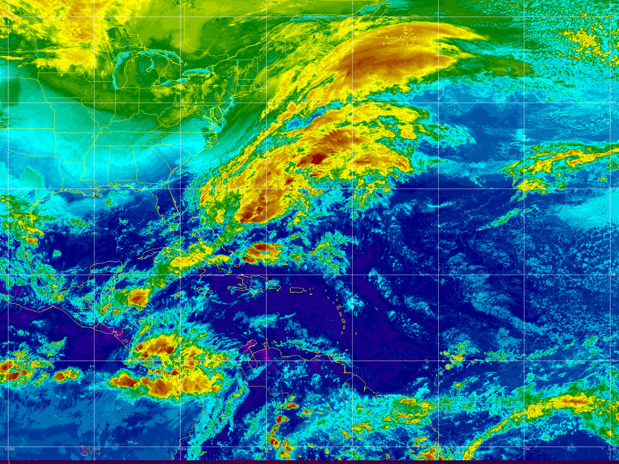
Monday Morning ... Tropical Update. Discussion on Possibility of Tropical Formation in the Atlantic Later This Week? Next Week Closer to the E Coast? Are Florence and Gordon Out There?
Newest waves off of Africa.
Low but nicely holding together.
More where those came from...
In the Gulf of Mexico and off the Carolina Coast...
...convection continues to bubble up and not fade away.
Mid Atlantic Under the Gun This Year from Wicked Weather. Will A Hurricane Come It's Way Too? Too Soon to Say But Signs From the Past Point to Tropical Trouble.
This is where we are this morning. A big, colorful tropical wave prepares to leave Africa. A suspect area of convection will flare up as the sun gets higher in the sky in the Gulf of Mexico. A long trail of deep tropical moisture runs from Florida up to Canada. The area most under the gun is the Mid Atlantic northward including a good part of the Carolinas. Florida will get more rain than usual from the GOM as it moves about in tandem in flow with the whole shebang that is messy and busy and everyone wants it to go away. It will go away, but it will be replaced with stronger waves and developing storms so are you ready for the Hurricane Season? I'm guessing if you are reading this you are more ready than the Average Joe. Note the white area of convection ahead of the new wave that loops like a leaping dolphin. That will allow this wave to stay alive longer than the last strong wave that tried to flare up just before it rolled onto the coast of South America.
The rains in Pennsylvania and New York will create havoc and when I say havoc I mean water rescues and property under water and the water is going to keep rolling downstream to the lowest point and then it may keep rolling. Rivers will rise. What starts in PA often ends downstream in DC, Maryland and parts of Virginia. The Mid Atlantic really is in a set up going into the hurricane season that isn't pretty and way too welcoming for any tropical system pushed westward too close to the coast by a large persistent Atlantic High. Note the map below by Cranky of the current set up. The current set up is waiting for a system from Canada to finally move in and rearrange the flow. The problem with this set up is if it hangs around in any way and you throw a tropical marble into that pattern it only brings more trouble to the Mid Atlantic. When I harp on the Mid Atlantic it is because it's not a good set up for them this year, but anywhere along the coast from the GOM to Florida has to watch carefully when the Bermuda High breathes, expanding in then out then in again. Highs do that they remain anchored but they float around a bit near that anchor and every degree it pushes West or East means escape or landfall for a hurricane.
Nothing stays the same though there are commonalities. In the same way that we are young and then we get older, some of us get wiser and some of us don't... the story is in the telling. A young hot looking guy who enjoyed playing sports turns into a fat slob from drinking too much beer and eating too many chips while watching sports and is too tired to get up to go to the fridge to get another beer. His wife who was a hot young thing before she had 3 kids and cut her long blonde hair short because it was easier has to shop at a large size store and wanders in and out of Weight Watchers trying to lose that extra fifty pounds. She gets him the beer, she plays Candy Crush and nibbles on M & Ms which is a far cry from what she used to nibble on back when they met. Life's not bad for the aging happy couple but it's not what it was and neither are they. You think I'm depressed right? Nah.. being playful.
So you have this set up with the High Pressure and Cousin SAL is the hottest guy in town. He blows out hot Saharan Dust lighting up the sunsets in tropical hues and everyone thinks he's their hero. Lord knows we all need heroes. After the 2017 Hurricane Season people will take any hero they can get to go through that again. We grasp at heroes named SAL or "Cooler Water Temps" (It's just a bit cooler? No problem we'll take it!!) or the always popular EL Nino. But no matter how bulked up Cousin SAL is at some point he begins to get tired of dealing with the incessant, insidious tropical waves and he's not getting as much support from his friend "cooler waters" like he did earlier in the season and by late August Cousin Sal becomes a really big sloppy mess. El Nino comes in like the Trojan Horse ready to save the day (a dollar short and way too late by the way) and delivers what could be crappy weather to many parts of the country that will then be blamed on El Nino that goes fast from friend to foe.
I'm pretty sure that old Homer was probably pretty hot when he was young, I mean his wife is still pretty hot in a Smurfy kind of way with the blue hairdo. But I think you get where I'm going with this in that things evolve and what is on the weather maps today evolves into a bigger problem during late August and early September. I do think in fact we will have something to talk about the first week of August in the Atlantic but either way the area close in that gives us Home Grown could produce a named system or a pain in the rear end no name storm that brings strong weather and more flooding rains to some area along the coast. Keep watching. For now SAL is strong and so is the moisture feed running out of control until some Canadian front pushes down and it being July doesn't help much as it's a bit early for that, however I have leaves on my Maple tree in Raleigh that are beginning to turn yellow so I'm guessing we are just running fast and furious towards Fall this year.
Mid Atlantic.
Keep it mind.
Today and down the road.
In Raleigh this big beautiful pecan tree came down.
What is it about people that makes them get crazy hysterical about some one online or leads to road rage when cut off but we cry when we see such a beautiful old tree that came crashing down. Anyway... I suggest you learn the differences in the Flood Watches and Warnings that the NWS puts out so linking to an article below that is worth you taking the time to read. Do you really know what an AREAL FLOOD is or do you think it means it's a real flood? Wrong. Please read especially if you live near a stream that is high or in an area already water logged from recent rains.
Do you really know the differences? Now would be a good time to learn them and be aware of the specifics your area might be dealing with during the next few days while tropical convection keeps being pumped up over a good swath of the East Coast. That said, places out West had flooding today also so it's a lesson everyone needs to learn because even in a desert there is sometimes rain.
Knowledge is power. I say that all the time here and in person and it's true.
I'll be back when there is something to report or to make an update. I'm in pre travel mode as I'm preparing to go back to Florida for a little while for some family happenings and I'm sure the photos in my blog will reflect that change of scenery. Keep smiling, stay alert and enjoy the quiet times if you are not under the gun from wicked rain storms.
Besos BobbiStorm
@bobbistorm on Twitter
Not proofing this so if I made a mistake... sorry and I'll fix it later.
Ps Using that knowledge you have to know that the Saharan Dust will eventually give it up to moist, tropical waves and the shear zone gives way to kinder aspects for those tropical waves trudging Westbound. 1985 and 2012 had similar set ups and they both had impacting hurricanes along the Mid Atlantic. If you aren't familiar with hurricane history then look up the names Gloria and Sandy. That is why I worry as our set up this year mirrors similar set ups, however the monkey wrench is that every hurricane season is just a little bit different from the analog one.
UPDATED - TS Harvey, Invest 93L CV Wave, PTC10 Off SE Coast Headed to SC, NC Possibly TS IRMA Later Today... TORNADO WARNINGS CURRENTLY ONGOING
Harvey
Just goes on and on and on.
Yet he will eventually move on.
Exhausting tragedy.
Still a Tropical Storm
Still a Flooding Problem.
And off the East Coast of the US..
That bright red area is PTC10.
What was once Invest 92L
PTC10
There is intricate discussion going on as to whether or not this system will eventually become a Tropical Depression or Tropical Storm. Yet....it has 40 MPH winds, remember that. Suffice it to say a storm by any name is still a storm and there is stormy weather moving en masse along the East Coast of the United States. So let's focus on the weather and not the discussion of the name. The winds are there for Tropical Storm strength as it currently has 40 MPH winds, however it's circulation is not complete. There is heavy rain along this stormy patch of weather and some possibilities of flooding in areas in Eastern NC that are prone to flooding. The beaches have high surf and rip currents and it looks...well...very stormy. Here In Raleigh there is a constant, beautiful breeze with light rain. Feels tropical ... feels a bit like an early Autumn Cool Front and then it feels tropical again. As it moves up the coast beyond the warning areas the beaches along the Del Marva Peninsular should see storm whipped surf. Nothing like what it could been had the shear enhanced by Harvey had not been there to create problems for 92L (PTC10)
And, then Labor Day Weekend comes with no big storm threat along the East Coast. That may happen later from Invest 93L in the Atlantic but this week enjoy life and have a wonderful Labor Day Weekend.
From Discussion below.
93L Models - Discussion.
80% chances in 5 days.
40% in 2 days.
Has a nice spin.
Really too early to tell where it's going.
For now WNW... maybe NW..
Then maybe bend back to WNW or W.
We have lots of time to watch.
Below is a comparison.
Compare and contrast Harvey and PTC10
Both with low intensity forecasts.
Tropical Storm...
Then a ticket out of town..
PTC10 .. ? Irma sooner.
Harvey later.
But they will go..
Good solid discussion from the NHC. A dry slot visible on water vapor imagery shows things are beginning to happen regarding Harvey. Yet, he has not started to make his move. Winds will be felt in areas where people are trying to put their lives back together close to the coast where Harvey originally made landfall. This can be seen on the water vapor loop I am posting from LSU below.
The basics regarding PTC10 are as follows. Currently it's awaiting better organization and stronger wind speeds for an upgrade to TS Irma. PTC10 is dealing with shear from the outflow of Harvey and close to a stalled out frontal boundary. It has a small window of opportunity and should it take that opportunity it will become Irma. If not it will be absorbed into the larger system that will move rapidly off the East Coast and take it out to sea. Even then it will enhance the power of that overall larger system and bring strong weather in it's path. You will start hearing words and explanations on what is Extratropical and the word Baroclinic may get bantered about by meteorologists. Don't get confused with names, a storm by any name is a storm. Plain and simple. Plan accordingly. Note below an image posted by Dabuh who is famous for his surf and weather reports. It's a reliable product. It shows a Possible Tropical Cyclone.
Currently a sort of one sided STORM system.
Cradled in the curve of the Carolina coastline.
This is the area that will be impacted by PTC10
The cone is wider.
That's a forecast coordinate.
Cone below from earlier.
Nothing new there.
I want to be really clear here. PTC10 is NOT Tropical Depression Ten. They are not the same the P stands for POTENTIAL and most likely it will become Irma, however I have seen posts online by many who should know better who simply say TD10. Yes, details matter. Words matter.
As for Harvey, it is currently a Tropical Storm and forecast to stay a Tropical Storm. That can change as always so stay on top of it if you or loved ones are in your path. As Houston is the 4th largest city and much commerce goes through that large area this is an economic mess for many as well as a personal tragedy for those in it's path. The NHC puts out a good product that is shown below. It's the basics, pictures, words; more words than Twitter and Snapchat but concise and well done.
See this image below:
When NHC links to the NWS.
Follow those links.
Links now show NWS Lake Charles.
Note the heavy moisture is moving East ..
My thoughts from last night remain the same, you may want to read them below. Anytime a system is back out over the water in enhances the moisture and the misery. The loop below shows how that moisture is being funneled up and over the area making TS Harvey look more like a Stationary Twister on satellite imagery than a true Tropical Storm. The winds are there and it has a viable center, despite the odd signature on satellite imagery.
My thoughts are with you Texas. My prayers are with you. I've donated to the http://www.redcross.org/ and I hope others do as well.
As for the rest of you in Hurricane Country... Remember September. Hurricane Season is just ramping up. Get a plan you can execute and be realistic about the threat this Hurricane Season may pose to your particular place in the scheme of things. El Nino is no longer in charge and Hurricanes are back in style again.
Besos BobbiStorm
@bobbistorm on Twitter
I'll update at the top throughout the day.
Or start a new post if NEW possibly.
Check back often for updates.
Thank you..
Location: Miami, Raleigh, Crown Heights, Florida, United States
Weather Historian. Studied meteorology and geography at FIU. Been quoted in Wall Street Journal, Washington Post & everywhere else... Lecturer, stormchaser, writer, dancer. If it's tropical it's topical ... covering the weather & musing on life. Follow me on Twitter @ https://twitter.com/#!/BobbiStorm