Hurricane Harbor

A writer and a tropical muse. A funky Lubavitcher who enjoys watching the weather, hurricanes, listening to music while enjoying life with a sense of humor and trying to make sense of it all!

Tuesday, May 21, 2019

Updated 5 PM. Subtropical Depression Andrea & NHC Break Up - Severe Weather Continues with Flash Flooding on the Plains. Other Regions to Watch in the Tropics....


Not sure what we are calling it.... 
Post Tropical Cyclone?
Funny part is it doesn't look much different.


Note the new discussion mentions the Upper Level Low.
It mentions the ULL in the way that I did earlier this morning.
The real culprit here is shear and the ULL.
Yeah.... it's weaker.
Signature looks not as strong but closed.


The shear to the North is evident.
The ULL moving to the West is evident.
And even the NHC says the ULL is the dominant feature.
Note below the remnants of Andrea are marked....
Far to the North of the swirl that looks like Andrea.


Ex Andrea.
Seems the NHC broke up with Andrea.
It was a fast, short, bad relationship.
It served it's purpose I suppose ... 
Next name on the list is Barry.


I knew a boy named Barry once....
...he was cute. 
Good dancer.
6th or 7th grade.
I digress....

There really isn't much to say here.
Except that if there is no real convection left...
..and no real center left.
Then it would seem to me that the convection ...
...associated with the system once known as Andrea remains.
The Upper Level Low is moving slowly West.
Does the moisture still fly off with the "front" ??
Or .... ??? linger around longer.
So many questions so little time.
We will see soon enough.

Elsewhere there are tornadoes, flash floods and misery.
You don't need a hurricane for misery.
Keep watching to see what will be...

animate.png (1200×875)

Not expecting anything immediately but who knows.
A week ago the NHC insisted nothing was forming.
Then they went from 70% to ANDREA

Stay tuned.... 
Barry is the next name.
He's out there somewhere.
Hopefully with a better presentation.
Til then give to the Red Cross.
Or give another reliable charity in the area.
The people being plagued with floods will need help.

And continue reading please there are many tropical thoughts.
Down past the 5 AM advisories.
Areas I'm watching for future development.


I'm going to keep this simple today and update later if necessary. Subtropical Storm Andrea is doing so far what was expected of her by forecasters at the NHC. A look at Earthnull from yesterday at this time compared to this morning shows how Andrea developed.


Before above.
This morning below.


That's a dramatic difference in 24 hours.
And while she doesn't show up well on the satellite image.
You can see down through her on this site and see the winds.

Going wider I want to point out a feature.
Between the coast of Florida and Andrea...


If you look closely you can see the mid to upper level low.
You can also see the shear to her NW.
This squeeze play has been going on for a while.
Yet she developed.
Partially ventilated by the ULL in the right location.
Marginal warm water temperatures.

Now let's look at the "cold front"

allfcsts_loop_ndfd.gif (799×559)

I wouldn't call it a "cold front" as much as a frontal boundary.
That wiggles around and then high pressure builds in again.
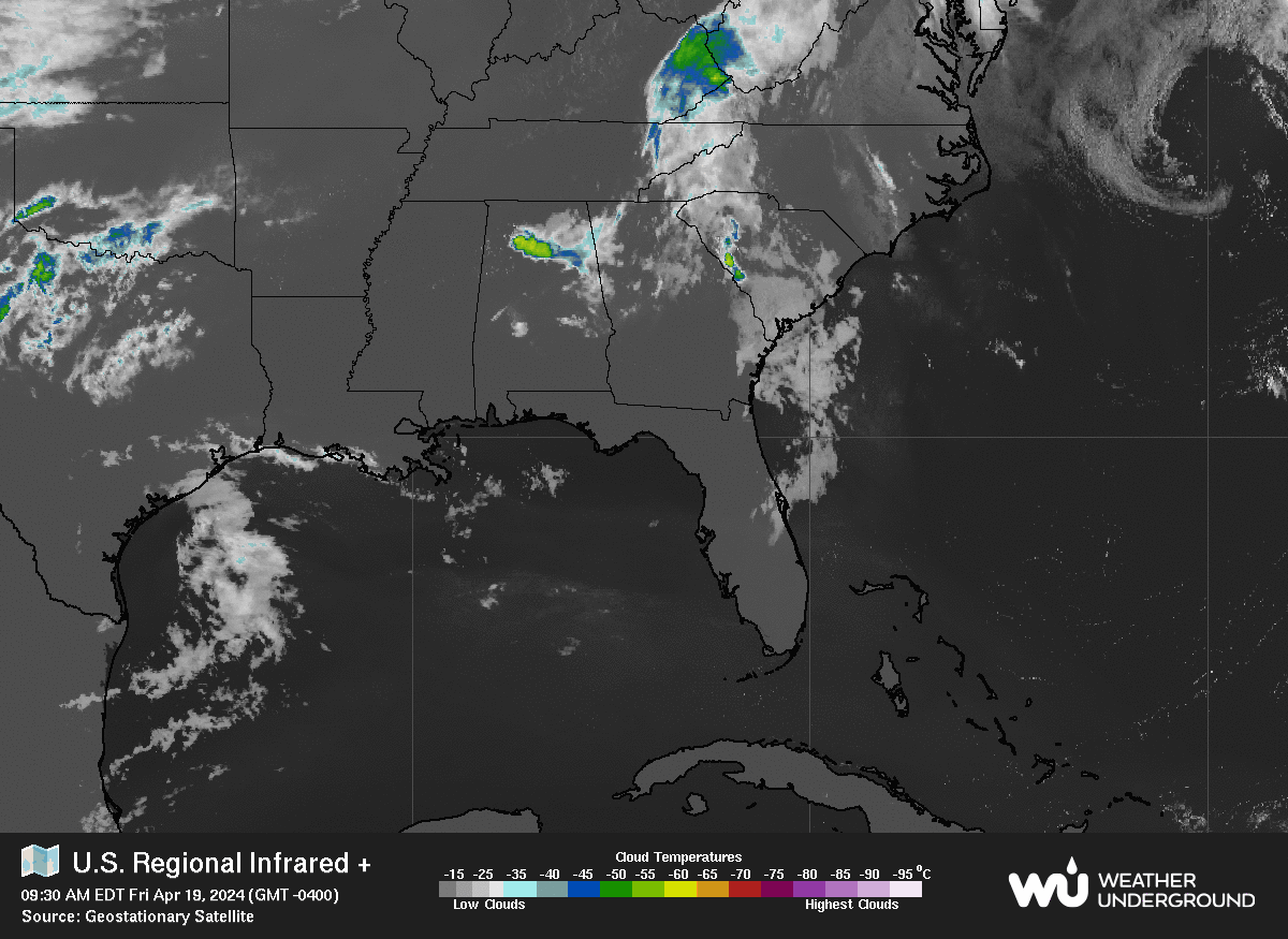
Also note the continuance of severe weather on the Plains.

There's an old chart that was one of the first wind charts.
My son when he was at Iowa State helped create this site.
It was actually an "art" site using meteorology as a base.


It's interactive.
Play with it... it's fun.
Once someone does something...
..... everyone copies and improves it.
But it shows the scope of the Low over the Plains.


Another view of the ongoing severe weather event.

Back to the tropics.


You can see both systems.
Remember it's a subtropical because of it's presentation.
And it's relationship to the secondary low I mentioned.
Note there will be serious flooding situations today ...
... flooding across the Mississippi River area.
And that's an area that doesn't need more rain.
It will also continue to rain in Texas and Oklahoma.
And when I say flooding I mean Flash Flooding.
And five days worth of flooding rains are possible.


Another area I want to point out is in the SW Carib.


There has been a constant increase in convection there.
Some models a while back showed development in that area.
The models went a little too Gonzo over development.
We discount models that show storms not in line with Climo.
But it's good to remember they were showing development.
Any area in that area that moves North will move into warm water.
And from the sites shown below the water is warming up.
As we move deeper into May and into June this concerns me.


This site is shown on www.spaghettimodels.com

If shear relaxes there we could have a problem.
As some of those crazy models implied.
And some of us are still watching that area.


Speaking of crazy models.
Check a few of those Andrea models.
Hmnnnn ....


The good news is most of them do go ENE.
What are the other lost models seeing?
Andrea is expected to go out to sea.
But there are other fish in the sea as well.

I'll be back later today as needed.

Remember weather is relative.
It's all a matter of perspective.
If your town got slammed by a tornado last night...
...the hyped outbreak materialized and messed you up badly.

If it's 90 degrees in the shade and it goes down to 88...
I guess it cooled off......
It's not such a strong cold front.


But the shear and the interaction with the Mid Level Low.
(Yeah it was Upper Level now it's more Mid Level)
Will steal the convection from Andrea...
..and Andrea will weaken as expected.
Keep watching.

Remember the big swirl you see here is not Andrea.
It's the Upper Mid Level Low...

GOES16-TAW-08-900x540.gif (900×540)

When an ULL is SW of a developing tropical cyclone ....
...it helps ventilate it some.
Change the location a bit and it can help destroy it.

Let's look at a shear map.


And leaving you with a site you can play with if bored today.


Current image.
Last night it was crazy.


Turn the sound up.
Enjoy...


Have a great day.
Stay safe if you are under the gun weather wise....
... keep an eye on the tropics if you live in FL or along the GOM.

Besos Bobbistorm
@bobbistorm on Twitter and Instagram.


(yeah I'm that person)
:)


Labels: , , , , , , , , , , , ,

Tuesday, July 24, 2018

Mid Atlantic Under the Gun This Year from Wicked Weather. Will A Hurricane Come It's Way Too? Too Soon to Say But Signs From the Past Point to Tropical Trouble.


hiatlsat_None_anim.gif (768×496)

This is where we are this morning. A big, colorful tropical wave prepares to leave Africa. A suspect area of convection will flare up as the sun gets higher in the sky in the Gulf of Mexico. A long trail of deep tropical moisture runs from Florida up to Canada. The area most under the gun is the Mid Atlantic northward including a good part of the Carolinas. Florida will get more rain than usual from the GOM as it moves about in tandem in flow with the whole shebang that is messy and busy and everyone wants it to go away. It will go away, but it will be replaced with stronger waves and developing storms so are you ready for the Hurricane Season? I'm guessing if you are reading this you are more ready than the Average Joe. Note the white area of convection ahead of the new wave that loops like a leaping dolphin. That will allow this wave to stay alive longer than the last strong wave that tried to flare up just before it rolled onto the coast of South America. 

The rains in Pennsylvania and New York will create havoc and when I say havoc I mean water rescues and property under water and the water is going to keep rolling downstream to the lowest point and then it may keep rolling. Rivers will rise. What starts in PA often ends downstream in DC, Maryland and parts of Virginia. The Mid Atlantic really is in a set up going into the hurricane season that isn't pretty and way too welcoming for any tropical system pushed westward too close to the coast by a large persistent Atlantic High. Note the map below by Cranky of the current set up. The current set up is waiting for a system from Canada to finally move in and rearrange the flow. The problem with this set up is if it hangs around in any way and you throw a tropical marble into that pattern it only brings more trouble to the Mid Atlantic. When I harp on the Mid Atlantic it is because it's not a good set up for them this year, but anywhere along the coast from the GOM to Florida has to watch carefully when the Bermuda High breathes, expanding in then out then in again. Highs do that they remain anchored but they float around a bit near that anchor and every degree it pushes West or East means escape or landfall for a hurricane.


Nothing stays the same though there are commonalities. In the same way that we are young and then we get older, some of us get wiser and some of us don't... the story is in the telling. A young hot looking guy who enjoyed playing sports turns into a fat slob from drinking too much beer and eating too many chips while watching sports and is too tired to get up to go to the fridge to get another beer. His wife who was a hot young thing before she had 3 kids and cut her long blonde hair short because it was easier has to shop at a large size store and wanders in and out of Weight Watchers trying to lose that extra fifty pounds. She gets him the beer, she plays Candy Crush and nibbles on M & Ms which is a far cry from what she used to nibble on back when they met. Life's not bad for the aging happy couple but it's not what it was and neither are they. You think I'm depressed right? Nah.. being playful.

So you have this set up with the High Pressure and Cousin SAL is the hottest guy in town. He blows out hot Saharan Dust lighting up the sunsets in tropical hues and everyone thinks he's their hero. Lord knows we all need heroes. After the 2017 Hurricane Season people will take any hero they can get to go through that again. We grasp at heroes named SAL or "Cooler Water Temps" (It's just a bit cooler? No problem we'll take it!!) or the always popular EL Nino. But no matter how bulked up Cousin SAL is at some point he begins to get tired of dealing with the incessant, insidious tropical waves and he's not getting as much support from his friend "cooler waters" like he did earlier in the season and by late August Cousin Sal becomes a really big sloppy mess. El Nino comes in like the Trojan Horse ready to save the day (a dollar short and way too late by the way) and delivers what could be crappy weather to many parts of the country that will then be blamed on El Nino that goes fast from friend to foe. 


I'm pretty sure that old Homer was probably pretty hot when he was young, I mean his wife is still pretty hot in a Smurfy kind of way with the blue hairdo. But I think you get where I'm going with this in that things evolve and what is on the weather maps today evolves into a bigger problem during late August and early September. I do think in fact we will have something to talk about the first week of August in the Atlantic but either way the area close in that gives us Home Grown could produce a named system or a pain in the rear end no name storm that brings strong weather and more flooding rains to some area along the coast. Keep watching. For now SAL is strong and so is the moisture feed running out of control until some Canadian front pushes down and it being July doesn't help much as it's a bit early for that, however I have leaves on my Maple tree in Raleigh that are beginning to turn yellow so I'm guessing we are just running fast and furious towards Fall this year.

Mid Atlantic. 
Keep it mind.
Today and down the road.


In Raleigh this big beautiful pecan tree came down.


Beautiful house.
Beautiful tree.
Withstood many a hurricane.
But it came down from a strong storm.
Maybe it was tired.
Maybe just the storm was strong.


What is it about people that makes them get crazy hysterical about some one online or leads to road rage when cut off but we cry when we see such a beautiful old tree that came crashing down. Anyway... I suggest you learn the differences in the Flood Watches and Warnings that the NWS puts out so linking to an article below that is worth you taking the time to read. Do you really know what an AREAL FLOOD is or do you think it means it's a real flood? Wrong. Please read especially if you live near a stream that is high or in an area already water logged from recent rains.


http://www.weatherboy.com/different-flood-types-advisories/

Do you really know the differences? Now would be a good time to learn them and be aware of the specifics your area might be dealing with during the next few days while tropical convection keeps being pumped up over a good swath of the East Coast. That said, places out West had flooding today also so it's a lesson everyone needs to learn because even in a desert there is sometimes rain.

Knowledge is power. I say that all the time here and in person and it's true.

I'll be back when there is something to report or to make an update. I'm in pre travel mode as I'm preparing to go back to Florida for a little while for some family happenings and I'm sure the photos in my blog will reflect that change of scenery. Keep smiling, stay alert and enjoy the quiet times if you are not under the gun from wicked rain storms.

Besos BobbiStorm
@bobbistorm on Twitter
Not proofing this so if I made a mistake... sorry and I'll fix it later.

https://www.npr.org/2014/09/19/349621429/the-song-that-never-ends-why-earth-wind-fires-september-sustains Interesting article about a song about the 21st of September... the peak of the Hurricane Season. Will we be tracking??

Ps Using that knowledge you have to know that the Saharan Dust will eventually give it up to moist, tropical waves and the shear zone gives way to kinder aspects for those tropical waves trudging Westbound. 1985 and 2012 had similar set ups and they both had impacting hurricanes along the Mid Atlantic. If you aren't familiar with hurricane history then look up the names Gloria and Sandy. That is why I worry as our set up this year mirrors similar set ups, however the monkey wrench is that every hurricane season is just a little bit different from the analog one.


Labels: , , , , , , , , , , ,

Friday, June 08, 2018

Hurricane Aletta in EPAC Cat 4. Surprising Rapid Intensification. Suicide of Anthony Bourdain Surprising and Sad. Surprise Tornado in Wyoming & Volcanoes Erupting. Been a Surprising Few Weeks.


Today's weather surprise.
Rapid intensification of Aletta.


Oh look Bud is about to form also.


Hurricane Aletta.
Eastern Pacific.
South of Baja.
Cat 4

Track and visible below.


Another view below.


Very impressive.
Surprising.
Very surprising.
Rapid Intensification.
Few saw that coming....

I said it a month or so ago and I meant it when I said that this Hurricane Season will continue to surprise us in ways. A surprise is something unexpected and often happens fast the way flash flooding brought torrents of water racing down into Ellicott City last month. Surprising in the way some volcanoes suddenly blow their top and rearrange the landscape in different, often deadly ways. One flows in intense orange and red shades down into once suburban paradises and the other covers everything in it's path in deadly ash. 


Good article. 
Explains the why behind the death toll.

Speaking of deadly it's been a horrible week for surprising, shocking, sad news stories about suicides of individuals who seemed much loved and living the dream on top of the world. I say "seems" as we really don't know what is below the surface in someone's life in the same way we don't always know when a volcano is about to blow or the ground is about to shake. These sort of "events" leave us shaken to our core as it's not normal to feel the ground shake, rattle and roll and it's not normal to see someone who "seemed" to be so happy and alive take what seems to be his incredibly, beautiful life. 

About 6 years ago my daughter-in-law insisted I sit with her through the last few weeks of her pregnancy and watch one documentary after another on TV. We learned how they made jelly beans and candy canes and then we watched episode after episode of Anthony Bourdain living the dream. For me in reality it was a dream show as he found a way to combine geography, history and politics into episodes where he ate Oxtail Stew or Scotch Eggs. Whether he was in Vietnam or Peru or New Jersey he brought the flavor of the place as alive as he did the dish he was sampling. I have to be honest I always got Kate Spade mixed up with Kate Landry, so it took me a minute to figure out who took her life before I began to wonder what could cause a mother to bring such horror into her child's life. I know suicide is a short term solution to a long term problem and people who kill themselves rarely are thinking clearly. Sometimes a person at the end of a horrible disease chooses to pick the time they will die, but usually it's related to an overdose of drugs or an overdose of emotion. I was so stunned when my husband walked into the room this morning just a few minutes after Buzz Feed sent me a text of "Breaking News" that I couldn't say the words as it seemed incomprehensible that such a thing could happen. I simply showed him my phone unable to say Anthony Bourdain committed suicide.

Sometimes a surprise is a birthday party that someone tries to pull off or a sudden trip to Charleston that wasn't planned. Good surprises are way better than terrifying ones like a tornado on a clear day with nothing in the forecast mentioning a possible tornado or a volcano blowing while you are on your dream vacation in Guatemala. 


Bourdain told it like it was whether you wanted to hear it or not. He did a segment on Jamaica that told it like it is in ways and in ways it's a similar reason that it bugs me when people go to Cuba and stay in a State owned resort while going on a State approved excursion, spend money, take selfies and are clueless how the average Cuban lives. Living in Miami in Overtown or Little Haiti is not the same as living in Bal Harbor or Coral Gables and few of the locals party on South Beach yet on Ocean Drive the party goes on and on all night. It's like those "GOING OUT OF BUSINESS" signs painted on the windows of stores for the tourists to race in and buy "Miami Vice" tee shirts for every relative they have back home because the "store is going out of business" but that painted sign gets touched up every few months as the tide of tourists goes on and on. 

I know I sound a bit down but really the double dose of sad is heartbreaking and you wonder whether things really do come in 3s and I hope anyone who is even considering such a sudden, impulsive act reaches out and gets help before rushing into what seems to be a way to stop the pain when in fact it creates endless pain for those left behind who loved them. I know a friend who lost someone very close to him from suicide and I know it colored their world in dark, shades of stormy gray for a long time until they found ways to bring back some color and life back into their world.

https://suicidepreventionlifeline.org

I'd rather deal with a rapidly developing hurricane any day (like Hurricane Andrew was) than deal with a sudden 7.0 Earthquake or a flash flood or the loss of a friend or relative by someone who thought there was no other way...  Someone told me recently I was "always a strong girl" and that's true but no one really knows the fears going on inside your head and heart in the darkest of moments. My children have always kept me grounded as well as several incredible friends, as well as a husband who tries to make me happy with a sudden trip to Charleston or Southern Pines. It's the little things in life really. My secret? I never want to leave a legacy like that to my children, I never want to totally lose it and be on the cover of the National Enquirer and when my son sends me a video to a new trailer like Bumblebee (as he did just now) I take it with a huge sense of humor............ 

Life goes on if you keep trying to pull yourself out of the deep holes we so often fall into and sometimes we have friends who reach down and try to help us out and back into life. I wish you all the pleasure of having someone who is there for you when you need it the most. 

As for weather..........this is typical of a normal hurricane season. Epac percolates in June and we wait our turn until the water gets warmer, the wind shear dies down and the waves get stronger. While waiting on those Westbound waves we watch the tail end of cold fronts that linger too long around on either coast of Florida. Right now the tropical news is in the Eastern Pacific where it should be the first week of June. I do believe this will be an Average Hurricane Season meaning we will have a good amount of tropical storms, hurricanes and some sudden rapid intensification in our basin. It's splitting hairs to say above average or below average because when a hurricane like Andrew suddenly goes from a weak, barely there Tropical Storm to a Cat 5 Hurricane taking aim at your town it's a huge hurricane season you remember forever. 

If you ever feel sad or bad or as if the only way out is suicide think again. No one, no amount of money lost or even just a crappy day is worth forgetting that tomorrow IS another day and you could be on top of the world just days after feeling down in the dumps. Turn off the sad love songs, turn off the scary news, go for a walk, smell a magnolia or go to sleep and tell yourself tomorrow will be better. Make it better. Reach out if you need to talk. 


Besos BobbiStorm
@bobbistorm on Twitter

Ps.. In retrospect while looking for happy, smiling pictures of Anthony Bourdain it was hard to find one to use. Some of the "happy faces" look forced and that wry grin where you can tell he has deep thoughts he is debating on saying remain on his face in most of the pictures online. He will be very missed. 

https://suicidepreventionlifeline.org


Labels: , , , , , , , , , ,

Tuesday, October 24, 2017

Updated!! Invest 93L Forms in the Carib w 50/50 Chances of Development. Where Would It Go?

8 PM
No new changes.
Still even odds something develops...
...or doesn't get a name.
Hate to say:
"Time will tell..."
But.... Time will tell!


Loop:


Compare and contrast...
See... no difference this evening.

Invest 93L is very close to the coast which is bad for the small towns and villages along the coast (and inland) and good for people in America that want to see the season die with Ophelia's controversial death over Ireland... downgraded just before she was about to walk onstage... Alas.....

In reality conditions are not that bad if and when 93L lifts away from the coast. The water is warmer, shear is low and conditions are forecast to favor development. The image belows shows the heat of the water that 93L will be moving over ... if it moves away from Central America and it should. 

ohc_naQG3_ddc.gif (824×617)

Note the flow on the water vapor loop.

sat_wv_east_loop-12.gif (640×512)

Sucking up tropical moisture.
In theory 93L slides in between two fronts.
Rides the rim of the front up into the Atlantic.
Maybe.

Again the some models show it going South.
Or lingering about.
Most models pull it up into the NW Carib.
And... out to sea.
Some models show moisture moving up towards NE.
Moisture not a closed eye.

storm_93.gif (800×600)

Stay tuned...

Going to put up 3 Tweets here.
1 is obviously about weather this week.
2.... is about history and Wilma
3....who doesn't love the Northern Lights?


He shows the possibilities.
He explains the logic.

Wilma...


Truly a bucket list item for many.
I didn't say "bucket list" :( 


Sweet Tropical Dreams,

BobbiStorm
@bobbistorm on Twitter

Ps.. I did go shopping but I didn't buy boots. I got a new bra from Victoria's Secrets and Jo Malone brought back the perfume I liked last October that was sold out by the time I decided to buy it... when God gives you a second chance on something you love you grab it! The saleslady threw in a full size lotion of Candy by Prada  and some small sample Candy sprays to take to Florida with me next trip. Okay I said it was my "signature scent" but she was so sweet. Like the way Candy smells ;) Nice day... out and about seeing some Fall color and cooler temperatures as the blue skies peaked through and the clouds from the last night's frontal passage pushed out to sea.  And that's just the way I rolled today. A somewhat more productive day than Invest 93L had while it plays peek a boo down in the Caribbean.

Bonus view of the flow that 93L is currently hiding in.. embedded in... I see where the moisture is going, the question remains will it get a name. What is in a name? Ophelia could write a book on that question. 

wv_namer_anim.gif (1024×900)


We now have Invest 93L in the Caribbean with a 50/50 chance of developing. Odds are funny in that how they are perceived are different according to what you are discussing. To some 50/50 chances of tropical development mean this will most likely get a named. To other people 50/50 means "meh" and "not gonna happen just your typical Caribbean Gyre dance going on down there. Imagine if someone told you that you had a 50/50 chance of winning the Lotto on any given day... How much money would you bet on that lotto with 50/50 chances I wonder?


In New York this may not seem like a cold front but in Miami people are paying close attention and adding layers they can take off later today when it warms up again. Today most people in the Southeast are talking about the cold front or depending how far South you live the "cool front" and it's big news. Again when the dew points drop everyone is happier in Florida so it's a mute point in South Florida just how cold it is going to get. A reinforcing cold front down the road helps everyone's mood as well. It may top out in the high 70s today in Miami, but this evening girls will be dressing up in their favorite boots with short skirts and tee shirts... possibly a sweater. The shorts, boots and sweat shirt look will be popular for the next few days as Miamians sniff cooler weather fumes. It's a great respite from a long hot summer that featured very tropical weather to see the fronds swaying and feeling like Mother Nature air conditioned the out doors for a night or two. In Green Bay that would seem like Indian Summer weather and everyone would be ripping off their warmer clothes trying to sneak in one more round of shorts and flip flops.  And like the lottery it's all a matter of perspective if you see 70 degrees as cooler weather or warm Autumn nights.


That's snow up there where it belongs.
Near Canada. 
Looks like half a heart.
A thin but noticeable front exists.

ECI8.JPG (640×480)

Another view below.
That's one massive low up there by the Great Lakes.

So let's go back to the tropics and 93L.
Below is a map of gas stations still open for 93L.
Should Philippe form....
...the red areas are where he gets his fuel.


Models... early models say this about that.


As I said the other day the models have been inconsistent. And, when they are inconsistent I look to see what they ARE consistent on ... what they agree on vs what they do not. The models show that something down there is going to form. And, whether it becomes Philippe and it begins to move towards Cuba and Florida caught up by the next cold front or a lingering tropical disturbance near the Central America there is one consistency and that is more, tropical weather for Central America. DaBuh shows that below and his concerns. We worry on a named Tropical Storm in South Florida, yet days of tropical rain could produce life threatening mud slides and flash floods whether or not a name is given to this area of tropical convection.  Perspective rears it's ugly head again..


The front that passed through Raleigh last night was nice.
Strong rain after a windy night and a light show.
Not much severe weather in RDU Land.


Down in Hickory it produced tornado conditions.


I'll update this blog later today as the various model runs come in showing possible tracks for a possible Tropical Storm Philippe.  We aren't expecting Wilma like development, yet it's worth reminding people that Wilma was forming today in history. Different storm, different year but the consistent part of the discussion is it rode a cold front North into Florida. If one hurricane could win an award for the "Best After the Hurricane Passed Named Storm" Wilma would beat out Andrew any day. After Andrew we suffered through hot, airless days in the 90s with no AC, no electricity, no water and not a breeze in sight. Miami kids love a breeze, we expect it as it's always a constant down near Biscayne Bay but not after Andrew. However, after Wilma caught that front the front pushed through and we sat outside under a blanket of a million stars in total darkness with cool breezes BBQing everything that was defrosting in the freezer and feeding the rest of the hood or anyone who wanted to sit around the campfire and enjoy some fresh air.  October often shows us fronts and hurricanes doing their Autumnal Dance and that's a given IF something really forms and IF the timing is just right. 


So really this is about timing.
Like everything in life.
IF Philippe forms...
...if the next front pushes through.
IF the timing is just right for them to connect.
Otherwise we could have a different story.
A story with a different perspective.

Note the image above.
It' looks like the Loch Ness Monster went South after Ophelia. 
A plume of tropical moisture from Africa to the Caribbean.
Pushing up into the Atlantic.
Anyone ever heard of the Sargasso Sea?
Gyres... sea serpents and legends.

rb_lalo-animated.gif (720×480)

93L doesn't look like much today.
At first glance.
Watch the loop a bit.
Something is beginning to begin.

I'll be back later with an update when we have better models and a clear cut look at just what could happen in the not so distant future. Honestly we aren't expecting anything to form today or tomorrow but the chances have now reached the 2 day page the NHC puts up and they continue to go up for the 5 day. And, as the loop above shows we know have a floater up over the area. Is this the last chance for tropical action of the named kind this season? I don't think so... I can see us getting to the R name just as easily as the tropics remain active and the parade of frontal boundaries only stirs the pot a bit more.


Personally I need a new pair of boots.
I'm talking a pair of boots I love!
Next trip to Florida I'm leaving my summer clothes there :)
Things are changing.
We aren't looking for a Cat 5 in the Atlantic.
Or even a Cat 4 in the Atlantic.
But we could see moisture moving Westbound...
..into more favorable areas.
And we also see fronts dipping down...
....then dying out.
So stay on top of the weather always...
...and have a beautiful day!

Besos BobbiStorm
@bobbistorm

Ps... for my Grandma Mary... there was really something about her and her memory lives on and on especially the music she loved to play on her piano. It's all a matter of perspective... this morning it feels a lot cooler in Raleigh than it did on Sunday at the State Fair.


Labels: , , , , , , , , , , , ,