A writer and a tropical muse. A funky Lubavitcher who enjoys watching the weather, hurricanes, listening to music while enjoying life with a sense of humor and trying to make sense of it all!
Thursday, June 30, 2022
NHC Says Probably Tropical Storm Bonnie Later Today. A Look Back at a Similar June in the 2018... Kind of a Typical Late June in the Tropics. Tomorrow July. TEXAS RAIN... (could be problematic further inland)
Colored Fruit Loops on the menu for Breakfast today.
Fruit Cakes on the map.
Fruitty Pebbles if you prefer.
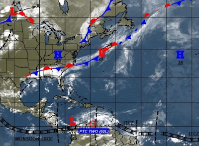
Two is Westbound with a name or not, going West.
Yellow X is meh but a wild card down the road.
Orange X is RAIN a lot of rain for Texas and beyond.
Note rain could hang a right....
Headed for Virginia. Maybe.
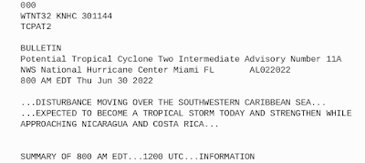
8 AM from NHC on PTC Two below!
* * * * * *
Take that to the bank, probably gets a name today.
NHC seems pretty sure.
So Bonnie could form on June 30th!
* * * * * *
In the long term there are always possibilities and then as they move into the short term they begin to fade away one by one. That's why we say "June Too Soon" though there are exceptions to the rule. The job of a model is to find a chance for possible development and they are upgraded and the models run again in several house, they are as Jim always says "guidance not gospel" so take the image below for WAY OUT in July as merely possibilities.
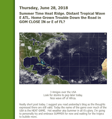
A look back in time to 2018.
Summertime and the living was hot and heavy.
Tropics came to life eventually in big ways.
A blog is a wonderful thing. My blog is a diary of sorts of tropical action and some personal discussion over time and when you look back you can almost always see the correlation to the current state of the tropics. June had been a beastly hot summer in Raleigh and the tropics were still flirting with activity. A very early GOM system developed, June was rather quiet and then close in action developed in July, as the year progressed we had Florence. Michael traced the earlier GOM system that began down by the Yucatan. "Waiting for the tropics to bubble more" is the phrase I used in 2018 and can use it again in 2022 on June 30th, 2022!
Lots of possibilities, but we aren't there yet. As seen below there's a front stuck across the SE, an active ITCZ but weak as it is in late June. Lows are marked but do not denote an official name, just the way of the world in the atmopshere. Gulf of Mexico action threatening. PTC Two more over land than not (which you see if you click on the image or enlarge it) and yet another Westbound Tropical Wave.
Will PTC Two becomes Bonnie today? Maybe.
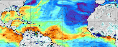
This is through July 5th...
This coming week shows possible development.
Red in Carib and candy stripe in GOM
(candy stripe mostly RAIN)
A wave off of South America periously close to crashing into it unless it lifts but the jury on that doesn't look good. If you use a magnifying glass you can see "something" of Bonnie on the coast of South America. That "something" will emerge over hot water close in and take aim at Central America.
Location: Miami, Raleigh, Crown Heights, Florida, United States
Weather Historian. Studied meteorology and geography at FIU. Been quoted in Wall Street Journal, Washington Post & everywhere else... Lecturer, stormchaser, writer, dancer. If it's tropical it's topical ... covering the weather & musing on life. Follow me on Twitter @ https://twitter.com/#!/BobbiStorm


0 Comments:
Post a Comment
<< Home