90% Chance Invest Becomes TS Bonnie. Caught Like a Ball in a Cesta Thrown at the SE Coast. Perspectives on Hurricane Sandy and NYC

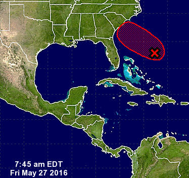
That red x issued at 8 am by the NHC is for within 2 days.
Formation chance through 48 hours...high...90 percent
The track for now remains the same.
The center is slowly coming together.
Hurricane Hunters will be going in this afternoon.
As I said yesterday it has to move over warmer water...
...get closer to the coast where there is less shear.
Doesn't look like that much now but it's a process


Going wide you can see the larger picture.I like the larger pictureSort of like a rookie quarterback in the pocket.Needs some maturity.Models are seeing the future... predicting the forecast.Note how it will be propelled towards the Carolina coast.Think of a Jai Alai player in action.Once the player catches the ball gets caught in the cesta(that wicker looking basket on his arm)He's swung around in a curve motion towards the wall.Bonnie will be propelled towards the coast in the same way.Most like this will become Bonnie.A player in her own right but caught up in the atmospheric currents.

Models are doing a good job this season at sniffing out development.

The process is more apparent here in the bigger picture on the long loop.There is a small chance, currently small.....oddball chance Colin could be develop.I'd put that between fantasy and who knows . . . for now.A sort of extra credit project while watching the loops and the Invest.It's important to remember for now this is an Invest.An area being investigated...Bonnie is the name it would get.Bonnie because we already had the A storm in January..For now models take it inland and then back out to sea.Strong, messy weather for the DC to NY metro area.Possibly Boston and Cape Cod.Again the problem is has currently is two fold.Water temperatures are only marginal.Then you see that deeper red orange tongue of color?Close to the coast.....approximately where shear lessens.There are two dangers with close in...One is obvious it develops on the coastal doorstep.Secondly while developing it sucks in a lot of moisture.Tons of tropical moisture.So from a relatively weak system you could have a large flooding problem.In an area that had flooding earlier in the year.Understand the problem?This is not Hurricane Andrew chugging to shore as a Cat 5.But it still has the potential to wreck the Memorial Day Beach Party.A big economic problem.And further inland as it rains and rains... cause possible flooding.Just a possibility to remind you weak systems can be a pain.As for the big picture that I love.Note IF anything developed further in the Bahamas.It's a long shot but even the thought that the Atlantic can cough up 3 systems.Before the Epac barfs up even one ...Is a sign that El Nino is on the decline, disappearing ....A real long shot but worth a mention.Note the Epac most likely will have a system soon tho..The weaker the Epac is the more energy is in the Atlantic.You can see the swirling . . .forming below.. slowlyThe bottom line from the NHCSalient points...Getting better organized.Recon going in.A threat to the SE coast in general.New update after 3 PM.Worth mentioning also the big NHC report is due out later today.We have the CSU report earlier in the year but the NHC waits...So the official forecast discussion for the Hurricane Season is today.I'll update this afternoon on the Invest and the report as well.Again the NHC says tropical or subtropical storm.Time will tell.I just wanted to add on perspective.It's a popular word these days but important.I sailed the harbor yesterday.Well it was a yacht but I was sailing :)You really don't realize how close the World Trade Center was.....how close the Freedom Tower is to the water.From the water it is right there rising almost out of the water.People staring up at the Freedom Tower...Rising up at the edge of the water almost.Caught in a traffic gridlock from a car.....you lose perspective.From the water you realize how vulnerable NYC is to a hurricane.From the water it's like you can reach out and touch it.Very vulnerable.And speaking of vulnerable...We sailed close to Breezy Point.A sailboat out ahead of us.A spit of land ... beaches... beautiful beaches.Just there in the middle of the water.Obviously a paradise close to the city on most days.Almost all days... except hurricane days.The air soooo fresh.Such an awesome breeze.Incredibly beautiful...At the edge of Queens and Brooklyn.Paradise unless there's a storm surge.Humbling even to me who knew and understood.But to see it for yourself up close from the water..Wow.Oh and they have these pirate ships and boats to watch the sunset in NYC.Everyone lined up with their cameras......felt like I was back in Key West.So know you can get a sunset cruise if you be in NYC.Besos BobbiStorm@bobbistorm on TwitterPs Got a laptop here to work on but not my normal one so..Thanks for the patience while on my NYC vacation!


posted by BobbiStorm @ 6:56 AM
![]()


0 Comments:
Post a Comment
<< Home