5PM Update..... Bret Now 65 MPH .. TD 4 Foms 2023 Tracking 2 Systems in Late June. Hurricane Prep Should Be Where You Are At.

65 MPH W at 16 MPH.
Center is the bottom blue clear dot...
left of the red blob of energy.
Ps it's not just shear.
There's dry air there seen below

Orange dots ...dry air.. SAL
Typical enemies of June tropical waves and storms.
Keep this in mind....
Always at the top of the cone site at NHC...
"Note: The cone contains the probable path of the storm center but does not show the size of the storm. Hazardous conditions can occur outside of the cone."

Bret 2023 looking a lot like Bret 2017
Further N and went further...

Bret 2017. Climo Wins Often...
...can it survive? Stay tuned... Models below.

TD 4

You can see track for TD4 bit too soon to be set in stone!
A look at Webcam on Windy.com for Barbados.

* * *
2 PM

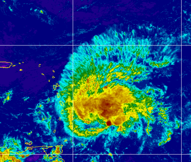
Shear definitely impacting it.
Visible imagery shows it's core to the W
...convection to the E
The beauty of a storm going "naked"
...is we see the bones and structure well.

See swirl, circle to the left.
convection to the right.
Still amazing for June.
Nice radar from Zoom Earth.
Oh look we can see TD4 and Bret here.
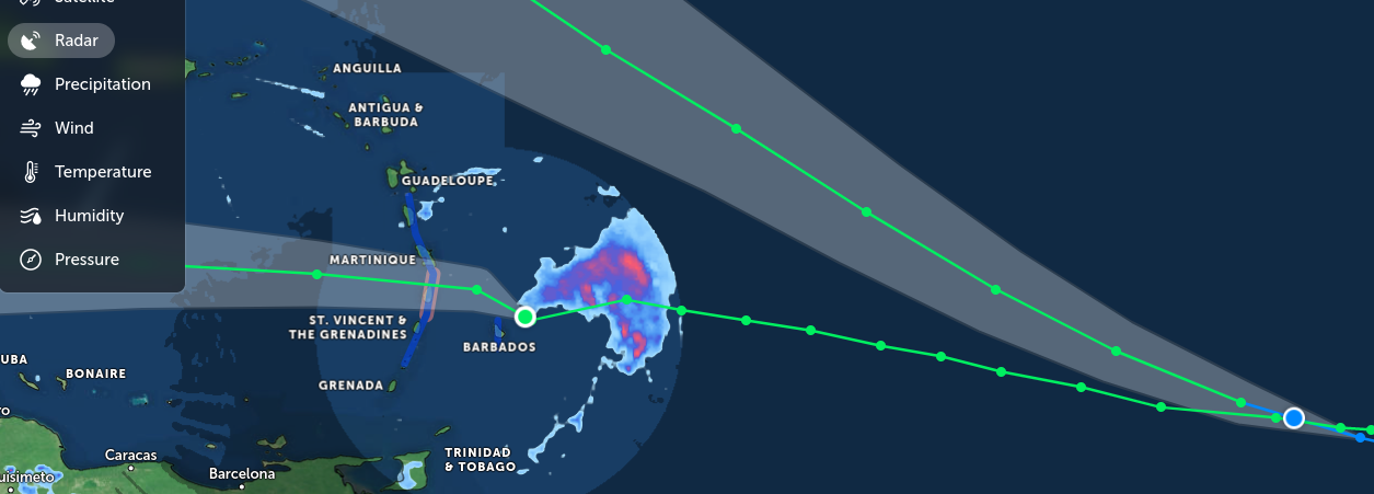
Will update after 5 PM.
(watching submersible drama honestly...
...while looping loops of Bret and TD4)
* * *


Hurricane Watch for parts of the Islands.
Discussion mentions it's strength on N side.
Good to remember.
Did Bret peak or is it still evolving?


Good product NHC puts out shows Wind forecast.
Go to the site, learn their various products.
Note it's almost touching PR but not quite.
Bret is a complicated storm, a complicate messy storm according to many but to me it's a fighter, fighting off shear and traveling through waters that few June Tropical Waves dare to even try. At times it tries to intensify and become a hurricane, at other times it's a tilted system (because of shear) trying to move west continuously despite less than stellar conditions to exist let alone even try and be a hurricane. This storm just doesn't want to give up. And, yet all storms meet their end eventually either raining themselves out far from landfall as Ida did in NY and NY or they unravel and fall apart due to shear and a lack of positive conditions in the Caribbean in June. Sometimes they end up staying together just enought to flare up later crawling towards Central America, once in a blue moon making it into the Pacific and once in a very rare blue moon they reform and try once again to stay alive. The ending is written in pencil right now, it's far from over but the odds are against it. That said...the odds have always been against it lol... seriously.

New kid on block TD 4 has higher latitudinal aspirations and models show it pulling NW making people from Florida to the Carolinas watch it more carefully, though Bermuda probably really needs to pay attention and well anywhere else in that direction keep watching should it intensify and develop differently from Bret that's doing a remake currently of Bret from 2017 and let's all pray 2023 is not a remake of 2017 in the tropics!

Allan Huffman is one of my weather favs in NC.
As mentioned on air today we are watching TD4.
He covers everything above.
He's very good.
Good to follow!
For Tropical Wxr or Snow!
So going to come back later today and see if Bret has peaked or tried once again to "come back" and how the models are handling TD 4 and never stop watching waves because the one behind TD4 should be an Invest sooner or later.

4 things to note here.
Far to the West is a vertical line... strong shear there.
Center stage TS Bret 70 MPH at 11 AM
Further East TD 4
Far to the East... next Tropical Wave

Image from WV Looop on Tropical Tidbits.
If you loop this excellent loop.
You'll see what's waiting for Bret.
* * *
10 AM discussion below.
Read it if you haven't it's still impt.
Or skip to the song below.

70 MPH Bret and TD4 sneaking into the close up.
Ever have a younger sister and in some corner of the image is this little head at an odd angle smiling trying to get in the group shot? That would be TD4 there, newly named, but let's stay with Bret this morning. Keeping this short and I'll update later as we see what NHC does at 11PM and wondering when the NHC will add the 3rd wave to the mix on the main page as it's obviously not fading away once off the coast of Africa.

June 22, 2023
Trying to channel up August...

Going with this image from Zoom Earth.
Check them out...
2 storms.
2 tracks.
1 goes W
1 goes NW.
Truth is I was a bit annoyed last night because it was obvious that Bret was intensifying and all I heard online was everyone trying to explain how you could see it was "falling apart from shear" when it fact it ws intensifying. You can't really judge a June TS in the deep tropics comparing it to an August/September TS in the same spot. It's like a little girl dressed up all cute in heels wearing make up ...she's adorable but not ready to compete as Miss America ya know. Into comparisons today.

Last night Bret was intensifying.
Why it was missed I don't know.
I know the excuses but still surprised me.
Problem with how many in the media and many mets have is how they sometimes fail to properly convey to the public the possibilities that could happen. Many are so tied to the previous forecast or their favorite model output, it becomes too Academic to many and as I worked in Academia running a library I learned way too much about Academia both good and bad.
A hurricane and sometimes even more a June Tropical Storm is the sum total of everything inside it whether it's perfectly formed or not. More so with a Tropical Storm that often has competing vortexes and wild flare ups of Thunderstorm with winds to Hurricane Force not perfectly aligned over the center. Tell that to the person whose windows blow out because they didn't think they needed to prepare that it was just some mini vortex not really the center of the storm. On the ground the impacts are differnet on every street, every island depending on random weather inside the named storm moving West or just N of West and it's not very academic when the tree in your front yard falls in a stronger gust than you thought you'd get and part of the ficus tree is blocking your front door.
So that said........no matter where that flare up was noticeable and sustained for some time in Bret it was obviously banging on 70 MPH winds door and to write it off and put out an advisory that just kind of extrapolates the previous one without pointng to areas within the strong Tropical Storm could have a strong punch depending on what cycle it's going through as it comes through the Islands. And, sometimes when shear is shoving, rearranging and trying to tear apart a TS trying to be a Hurricane entering the Caribbean someone in the Islands gets a crazy intense part of the storm while others just get some healthy rain
Whacky things happen in situations like this and it's best to err on the side of caution and not be so locked into an original forecast by leaving the door open for stronger weather, and to be fair the NHC did put up a Hurricane Watch currently for the Islands.

We will discuss the models later.
And TD 4 later.

Stay tuned...
I'll add a song when I finish later..
Waiting on 11 AM Advisory....
Sweet Tropical Dreams,
BobbiStorm
@bobbistorm on Twitter and Instagram
Twitter mostly weather and Instagram weather and whatever...

From Publix site........
...good checklist!

https://www.publix.com/pages/publix-storm-basics Figure it out now because one way or the other there will be many more dangerous threats than Bret... 2023 will stay busy for a while even with El Nino trying to shut down the latter part of the season. Prepare, make a list, do what you have to do if you live in Hurricane Country. If you lived in Buffalo and were new to the area tell old timers "I'm sure it's not going to be that bad in the Winter......" listen to old timers!
posted by BobbiStorm @ 7:14 AM
![]()


0 Comments:
Post a Comment
<< Home