Hurricane Harbor

A writer and a tropical muse. A funky Lubavitcher who enjoys watching the weather, hurricanes, listening to music while enjoying life with a sense of humor and trying to make sense of it all!

Wednesday, May 22, 2019

Tropics Quiet Today. Danger on the Plains from Tornadoes & Flooding Remain. Thoughts on How We Convey Real Time Weather Threats Referencing Article by Marshall Shepherd


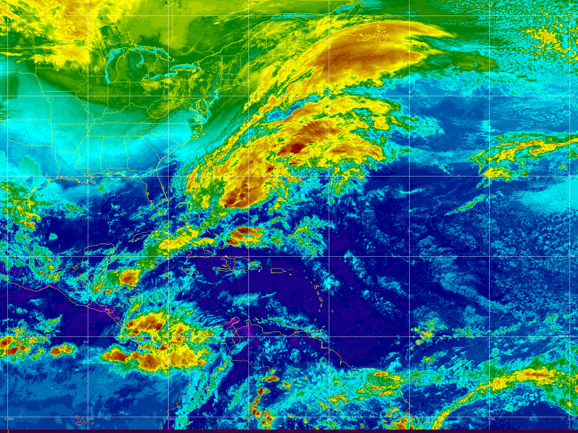
A quick perusal of Spaghetti Models shows there are no hurricanes today.
There is not even the ghost of Subtropical Storm Andrea.
Nothing is expected to form in the next 5 days.
Okay in truth some convection does remain....
But it is not expected to reform so let's move on.


There are things to think on down the road.
Areas in the Caribbean that sometimes flare up in early June.
They flare up there and move North into the Gulf of Mexico.
And sometimes they flare up there and move into the E Pacific.

GOES16-TAW-08-900x540.gif (900×540)

Convection is congregating down there.
Again it moves into the Epac where a storm may form.

I could tell you models have been a little awkward lately.
A few keep predicting development down there.
Long range models are meant to be visited often.
They are for entertainment purposes only.
The system on the Plains is still dangerous ...
...and still on the move.
It's far from over.

With Memorial Day Weekend coming remember this...
It's a good time to start preparing for Hurricane Season.

Today's blog is about a look back at this week in weather.
The high expectations for long tracking tornadoes... 
... and the reality that tornadoes did happen.
They were not long tracking EF5 Twisters.
But they destroyed people's lives.
And yet people yelled "busted forecast!!"
The forecast for dangerous weather verified.

The problem is how we convey what is dangerous.
The problem is our personal expectation of dangerous.,
The dangerous situation there continues.
And hurricane season is just around the corner.

The article below inspired me to write this today.
I'll talk models and satellite loops tomorrow.
I want to revisit some tropical weather history...
History repeats, it's good to learn from history.


The link to this article is below.
It's an article worth reading.
It's especially valuable as we head into the Hurricane Season.

https://www.forbes.com/sites/marshallshepherd/2019/05/21/three-problems-with-the-word-bust-during-real-time-weather-threats/#290dc83f5338 This is an excellent article that should open up our minds as to how we perceive real time threats or feel the need to communicate "what is dangerous" to the general public again often in real time. As the 2019 Hurricane Season is around the corner I find the need often to remind you to prepare for hurricane season. It is especially difficult at times after someone somewhere puts out predictions on how this may or may not be a busy or quiet hurricane season. These often circulated articles announce that the water is cold in the Middle of the Atlantic Ocean or Saharan Dust is blowing in the wind keeping the hurricane season weak or El Nino may or may not be leaving written often to capture the public's attention and get retweeted online. Public perception of danger is sometimes mitigated or heightened by these headlines and often there is a "boy who cried wolf" issue that arises later in the season when a hurricane veers away from a potential landfall and stays safely out in the Gulf Stream only kicking up big waves at the beach or when long tracking EF5 tornadoes do not form and people in the warned area let their guard down.

Long paragraph I know, but this is seriously a problem in today's world where people scroll through tweets or images on Instagram. Back in the the day people would complain that television news people wrote hyped up headlines or news promos that were merely "sound bites" to get you to check back at 11 PM for the late news. This is really a communication issue as old as time as I am sure somewhere cave people argued over dramatic cave drawings of lightning hitting a horse that was way over the top and not realistic. No disrespect to cave people I personally always loved the GEICO cave guy the best!

It's a problem as old as time in ways, and yet in today's very fast paced world it has it's own new unique issues. In today's world we have issues not problems. After a Presidential election years back it was discovered that by releasing early predictions when the East Coast polls closed on National News it had negatively impacted voter turn out on the West Coast. Many interviewed said "why bother voting as we were told who won already" and that's sad but it happened. News stations then agreed they would wait until the polls in the Pacific Time Zone were closed before making early predictions based on exit polls. If you are expecting large wedge tornadoes to be on the ground wiping out towns such as Moore and no big, huge EF5 wedge tornadoes wipe out Moore or Oklahoma City then suddenly we read on Facebook, Twitter and in our multiple Whats App groups that the forecast was a bust. This irresponsible message mistakenly gives many in the warned area the message to "stop worrying about it" when tornadoes were indeed on the rampage late into the night and early morning hours. Then those same people online and go negative about the media delivering the message saying that it was all hype and nothing more. The truth is the set up was there, there was potential and it was a forecast that thankfully didn't verify in the way that many thought it would.

The proper reaction should be to be thankful it was not worse.
And to be aware it's an ongoing dangerous situation.
As Reed tweeted yesterday.


Again it was only a "bust" in that long trackers didn't show up.
Other destructive tornadoes showed up.
And the dangers continue.
We are very happy the set up busted.
Again the "set up" that the forecast was based on.
Perception here is the devil in the details.


No it was not hype that the possibility was there for long tracking tornadoes, but there was also the potential for short flare ups of multiple tornadoes everywhere and the ongoing inherent risk of flooding. In the same way that if someone else has surgery you may think of it as minor surgery if it happens to you it is major surgery. If your town was severely devastated by a short lived, strong tornado you will remember it forever and consider the forecast to not have been a bust for a particularly dangerous situation.


Oddly I think of a Derecho when I think of PDS.


Waveland Mississippi Before and After Katrina.


Waveland's destruction often gets forgotten in the greater picture.


Take a look back at Hurricane Katrina that tore through South Florida as the first in several tropical systems that year to visit Florida, however most people obviously only remember New Orleans when they hear the name Hurricane Katrina. After Florida .... Hurricane Katrina made a second landfall near Waveland in Mississippi creating the slowly evolving horrible levee failure in the New Orleans area. Perception is in the eye of the beholder or whose home personally was damaged. Yes, Katrina was a National Tragedy that made us rethink many things but it was a personal disaster memory for many people far from New Orleans. Hurricanes history teaches us that hurricanes often do that especially the big ones such as Betsy in 1965 and Andrew in 1992 that made double landfalls in both Florida and Louisiana as they traced a path around a very strong high pressure area in the Atlantic that steers them into the Gulf of Mexico for additional landfalls.


History does repeat sometimes doesn't it?
The exact details are always a bit different.

Lastly after the fact discussion on a storm being a "bust" is really not necessary as many considered the Hurricane Irma forecast for Florida being wiped off the map a bust because it didn't destroy Miami or Tampa, however tell that to my friend in Big Pine Key who lost the family home and was forced to demolish it's remnants recently. There is always so much hype online and on air regarding large targets such as Oklahoma City in Tornado Season or Miami in the Hurricane Season. While Category 5 Hurricane Michael was in the slow process of coming together down near the Yucatan and Cuba many meteorologists doubted online complaining the forecast was poor and that "this thing is never coming together" in the same way that model forecasts for huge flooding in Houston from Harvey were played down as "garbage runs" and "probably won't happen" and yet the forecast actually played out even worse than forecast. Many tweeted on Twitter how the landfall of Harvey near Rockport seemed not to be that bad.... in the same way back when people watching New Orleans survive the winds of Katrina better than expected went suddenly quiet when the water began to rise.

There is much to think on as we work our way through the rest of the Tornado Season and move towards the Hurricane Season. When a 7.0 earthquake in a large city is first reported by some AP reporter it usually reads "no deaths reported" and we should know that means "no deaths reported yet" as we should not believe everything we read and wait until the rest of the story plays out.

Why the NWS went with the PDS warning? I'm sure it was to err on the side of caution and with concern that a PDS situation could happen. Why the NHC went with upgrading to Subtropical Storm Andrea I don't know, but I am sure they had their reason. It's not my job to second guess these things I prefer reminding you that now is the time to prepare for Hurricane Season before a hurricane is knocking at your door and the store is out of toilet paper, tuna fish and peanut butter! 


Ask the people who were impacted by a compact, Category 4 Hurricane Charley that seemingly surprised them because the media seemed to imply that Tampa was under the gun and they were in the outer edge of the cone from the NHC. It was not a busted forecast as much as it was not properly communicated that the danger of any small town in that part of the cone in Florida was liable to get the brunt of the hurricane moving parallel to the coastline before turning in towards landfall. 


Something to think on and to remember. No forecast can be 100% correct in the details even though the forecast for dangerous severe weather or a land falling hurricane will verify. Are you prepared is the bigger question?

Read the article linked to above and remember this applies to hurricane season and dramatic warnings on dire danger about to happen and how a busted forecast can have a boomerang danger such as flooding or even worse ignorance of similar warnings the next time a hurricane is headed your way.

Knowledge is power. Find out what you personally need to do to prepare for Hurricane Season.

Besos BobbiStorm
@bobbistorm on Twitter and Instagram.

Ps... Some video below from a friend who passed away but is always remembered from Hurricane Charley. Again... just because Tampa was not the landfall the forecast was not a bust and .... remember that sometime down the road Tampa will get a landfall again as they did in 1921 when a Category 4 hurricane made landfall in October. That is not hype it is merely learning from history. Turn the sound of it you prefer on CycloneJim's video on Category 4 Huricane Charley. 


Tampa Bay 1921 Hurricane not Charley.
Video from Charley below.


Labels: , , , , , , , ,

Tuesday, January 15, 2019

OH MY GOODNESS.... WINTER GOING TO COME BACK !!! Happy MLK Day on the Real Day Not the Weekend.


This basically began yesterday in ernest.
Headlines on Twitter showing SNOW and ICY weather coming!


The Polar Vortex is being unleashed!!
Yeah........ Winter is back!
My AC is off and my heat is back on!!
The beach a week ago was nice........
.... I didn't go outside today in Raleigh. Brrr...

Tonight's blog is a prelude to real discussion.
I want to show a variety of news and tweets.
The real news today was in California...
Dabuh knew that!
If there's a beach he's watching the surf.
And the weather.... he's a great weather watcher!


Prayers indeed as you will see deeper down in the blog.

Weather is locational and whether you live in Maine or Miami you have different priorities with regard to what you wish for......  and in this case be careful what you wish for....   Note the REAL storm is going on NOW in California but the East Coast, as always, thinks this is all about them and whether NYC or Boston gets Snow. The South looks longingly at the snow models wishing the system would take the more Southern track so that we could see some snow flakes falling and dusting our Carolina Pines. There is a middle part of the country, though to be fair they got the last snow storm AND Jim Cantore so they have plenty of stories to tell of the Winter of 2019!


I gotta warn you there's a lot of hype going on right now, because that's all we have is hype and models and watching the satellite loops. Speaking of models the Canadian is really on to something or just being the Canadian over amping every system and bringing snow to Cuba. It's worth noting it DID snow in Cuba in 1857 so I suppose it's not impossible. The EURO and the GFS (choose your version of it) do not show snow for Havana or Miami so you can breathe a bit and get out your favorite boots for weather diving down for one night into the 40s!

And the usual mets are having fun with this because to be honest we had one wild winter storm in November, a January thaw in December and now in January winter is showing up again on the models. And it seems this one will really do the trick and usher in some Arctic Air down into the US all the way down to .... Key West and do NOT laugh as Key West is an island in the middle of the Florida Straits and when a cold front breezes in across the water it gets down right chilly!


Yoda knows.... 

In truth though California IS having WEATHER NOW!
Yet you wouldn't know it from my feed ....
...that is heavily weighted to the Hurricane cities & Seattle.

There's a Blizzard warning up for the Sierras!


California is like the song....
I've lived there....
First comes fire and then the rain comes....
...and the mud runs down the hills.
It's one disaster after another... 


In Santa Barbara there was crazy wind damage. 


High Surf Warnings up the coast of California.


If you live in LA.........
........don't let your garbage cans float away!


But on the East Coast everyone is ready!!!
North Carolina and Virginia are waiting... 
NC won the November storm lotto...
VA stole last week's storm.
What will be with this next storm?


Allan Huffman is as reliable as it gets.
He's watching the models and we are listening.


In my mind it's going to Carolina......


No it's not really going to Carolina, not this week's storm.
But I'm driving North for the cold, frigid week down the road.
So I know I'll see snow one way or the other soon...

You heard about the 10 year challenge on Facebook?
30 years plus and James Taylor is still singing.
My best friend loves him.
Took me a long time to enjoy him again.
I can finally listen and smile.

What do you love?
Who do you love?
You love snow or hate it?
Doesn't matter.... 
...you get what you get.
Mother Nature's in charge of this one.
I know... Polar Vortex (rolling eyes)


Yah we have all these great terms these days....
........to describe Winter.


Love reading Cranky's BLOG.


Note there is a 2 part harmony here going on.
The storm THIS week........
.... the BIG storm next week!
Cranky likes to Tweet.
He loves to Blog.... 
Read his blog and then read it twice.


I know you want to know if Philly is gonna get snow.
SMH.......

Definite maybe.


Everyone's chasing after snow......


Or complaining about shoveling it!

And everyone who is Tweeting is ......
.....updating every few hours.
As models come and models go.
Soon we will really know.
Compare the below tweet with the above one.


A man of few words has this to say on the cold.


A man of many words and great wisdom is Larry Cosgrove.
You really need to follow him!


Yes Weather Twitter is a buzz and buzzing louder than transformers or swarms of freezing bees. What do I think? What do I know? When you have a period of warm weather deep in December you have to know that winter is going to come back with a vengeance. It's like during hurricane season when it's slow and early waves give it up to Saharan Dust and Shear at the Gateway of the Caribbean and you think there won't be any hurricanes and then Mother Nature is back with a bite and Twitter begins buzzing with innuendo and rumors and people act as if the world is coming to an end and on air news people say things like "unprecedented Arctic Invasion as the Polar Vortex is blasting it's way down into Florida" and you worry Aquaman is going to freeze and Lex Luthor finally discovered a weather machine that will control Earth's weather and then you remember Spring will come again. Kids enjoy the snow, parents shiver and shovel the snow and someone gets sleet which is about as annoying as rainy days and Mondays. 

So as for me I'm going to enjoy whatever we get this week and wonder on what weather I'll see in New York City next week as I'm scheduled to be there then. There's highs and lows near zero if the extremists are right and if it moderates in the teens... time will tell.

As for tonight, enjoy this song and know I love it...... really as much as the oldie goldies are great this song is perfect and note .... he uses weather because how can you show a love song without some kind of weather??


Besos BobbiStorm
@bobbistorm on Twitter

Ps... Don't say I didn't blog and as always I hoping you get the weather you dream about!

I'll be back with real hard data on what to expect from the storm after this storm and how frigid the temperature will be and just how low that freeze line will go. I suggest you familiarize yourself with the winter links on Mike's fantastic www.spaghettimodels.com as he's a guy for all seasons ;)


Labels: , , , , , , , , , , ,

Sunday, August 12, 2018

Updated......Monday Morning Flooding in the Mid Atlantic Again. 98L in the North Atlantic... the Hotter than Normal Hot Atlantic ... Models Take it South a Bit...


Satellite image

irng8kml.GIF (2000×1500)

Monday Morning.
Compare and contrast ....
Tropics are there quietly.
Waiting perhaps...
Or not.
Time will tell.
Everyone speculates.
Time will tell.

Michael Ventrice explains Invest 98L
And some thoughts on the 2018 season.


DaBuh dances to his own tunes.


Where would something go if it developed.
Climo and models are our guide.
Edge goes to Climo always.
Especially in odd years such as this.


Odd you ask?
Twisters at high latitudes not Oklahoma.
Flooding in Mid Atlantic on a regular basis.
Subtropical Storms on the Rampage.

Cranky keeps his priorities straight.
Rather than wonder too much on the tropics..
...or how soon winter will be here.
He lives in today.
Not a James Thurber type it seems...


While we wonder on the tropics.
NJ is flooding.
Pennsylvania often floods.
Maryland watches carefully.


Car dealerships.
Gotta move those cars.
Why are they always located in areas prone to flooding.
Raleigh has this problem as well.
Though they move them fast.

What I want to point out today is really what Cranky is pointing out more than anything else. Mother Nature as we like to call her always finds a way. Air flows from the equator to the poles and other times of year the air flows from the Poles South and sometimes it moves West to East and on some days it moves about so frantically that it looks like it's dancing at a rave with a light show and a pounding techno beat and when air moves that fast like a long run on sentence it's hard for anything in the tropics to get going. And, yet misery goes on and happens around the globe be it from a HaBoob or a Flash Flood or a wild Summer Storm on a dark humid evening. I95 floods just like that...1 2 3 and you can't get out of the left lane and high water is seeping into your car. Sometimes an idyllic afternoon outing on a lake in North Carolina can turn deadly when a storm blows up faster than you can get to shore. Misery is always blamed in hurricanes and natural disasters but it took a year for Ellicott City to rebuild and get halfway back to normal and then Mother Nature did it again.

Many years hurricanes form and go everywhere in the Atlantic but rarely make landfall. Wet tropical storms lumber towards the Gulf Coast causing more havoc than a well developed, small, compact Hurricane would have done. A compact Major Hurricane comes ashore in a nature sanctuary in Texas and everyone jokes that Bret was nothing at all. Other times a tropical depression drowns Houston the way Harvey did last year but on a smaller scale. 

So watch that loop below and note how everything is a bit chaotic this year and surprises will happen while we watch the North Atlantic to see if Ernesto forms there or it's just a Subtropical Depression dancing in circles until some weather feature picks it up and slings it out to sea towards Europe.


latest72hrs.gif (947×405)

Best song to watch this loop by below.


Song of the day.

I heard Aretha Franklin is extremely ill, possibly gravely, and I was going to put up I say a little prayer for you as a song but I really couldn't as I am so not there this morning. I really don't listen to "old" music much and when I do I only think to myself "so I used to listen to this all the time huh?" I may be crazy but I love how music evolves over time. I'm in love with the shape of you... and you in this case means weather, maps and music. Okay I'm also in love with a few people who mean the world to me. So I'll say a little prayer for Aretha and anyone else out there who needs it. But when I hear this song come on above it washes over me like a gentle rain allowing me to enjoy every drop, every beat at one with the world. 

Compare today to last night below.......

Besos BobbiStorm
@Bobbistorm on Twitter if you want to follow me and join in the discussion.

Ps...Oh Philly is flooding. Never count out a hurricane season until late November. Mother Nature usually finds a way to catch our attention at some point and this year it could be at a higher than normal latitude.


Putting this here for a compare and contrast for tomorrow morning.
Note the anomalously warmer than normal water in N Atlantic.


Also note the MDR region is warming up.

So I'll talk on this tomorrow.
You might be reading this Monday.
If so... it's tomorrow.
It will be updated in real time.


It dips down down down...
...then boomerangs back!
Never trust early models.

Then below you can see...
...there's always that one that breaks with the pack.


Let's look at a sat image of 98L


Yes that puff of clouds in the Middle of the N Atlantic is it.
I want you to notice convection in the Caribbean.
Shear remains high but if shear weakens...
Low pressure could form near Florida somewhere.
As they are having tropical downpours every day.

Also note the ITCZ is maintaining convection.
Change is in the air.

Good close ups on satellite imagery below of 98L


I just want to say that you can't really judge what the end result of the Hurricane Season will be from the flurry of high latitude Subtropical Storms going on at present. Even last year during the abundance of MDR hurricanes holding together as they traversed the Atlantic in search of landfall we had Gert up in the Atlantic spinning about. Years ago the NHC did not bother with these storms unless they were intense and on those occasions they tended to be real weather makers. They did not publicly track strong tropical waves or areas of low pressure in the atmosphere and not every small closed low in the MDR (Beryl) nor Upper Level Low was named as was Debby. So to compare now with then is not a level playing field. Often storms were added after the season during a reanalysis of the hurricane season and we never tracked them.

But now days with the tools we have available (see image above) we can track their movement from the NHC or even some bedroom of some kid who has an early obsession with weather and Apps on his iPhone. You really can't compare now and then. It is what it is. Let's see what it is on Monday afternoon.

Besos BobbiStorm
@bobbistorm on Twitter


Labels: , , , , , , , , , ,

Thursday, July 12, 2018

Somethings to Talk About Tropical and Otherwise. Chris, X Beryl Trying to Make a Come Back. Midwest Wild Weather. Cold Fronts Early. African Wave Train.


You notice two things here above.
Deep reds and oranges nearing the Great Lakes.
A large circulation off of Africa ...
..and a wave behind it coming off today.


Waves shown above.
Two very healthy waves.
Saharan Dust is waiting for them.
Classic for this time of year.
No not really...
...we are ahead of schedule this year.
The waves are actually healthier.


That's a healthy 

Put it all in motion.

hiatlsat_None_anim.gif (768×496)

The waves in the Atlantic are mentioned below.
Also mentioned are the high winds in the Caribbean.


Going to point out some things this morning and then move on to do some things I need to get done. I suppose we could name today's blog "Somethings worth watching" :)

When looking at the wide view of the Atlantic and it's associated land masses it is very hard not to notice the huge wave coming off of Africa. There is actually another huge wave axis that moved off of Africa recently that is maintaining convection on the South side of it much like Beryl and most strong waves do this time of year. They, like people, find their energy where they can get it and work with what they have to get where they are going. Some people like regular old American Coffee such as Folgers or Maxwell House, others like Nespresso like me...  some drink Coffee, Tea or even Red Bull. There are some rare people who don't do any form of energy or drink and they drink water. Well, water is the most beneficial energy drink any of us can drink and coffee, tea and even Red Bull start with water somewhere. Water in the tropics needs to be the right temperature to get tropical convection blowing and rolling so that it makes it's way across the Planet to ours side of the world. Each wave that dies out in the East Atlantic puts moisture into the atmosphere readily available to the next wave behind it. Waves are it seems "team players" having each other's back and lending support even when they aren't going to make the trek themselves.

The end result of this process is that when the Atlantic heats up a bit more and the Saharan Dust wanes some as it is prone to do later in the summer as we approach the peak of the Hurricane Season some wave coming off of Africa with a great looking low pressure center attached will develop and become a problem. Even somewhat slow years often produce one or two dangerous, way too viable hurricanes. Sometimes they develop close in and other times they take their time, getting dangerously closer to the Islands and then develop. Every year is similar, every year is different yet the one constant is Hurricane Season really gets going later in the summer. My one problem with this year is that it feels as if we are running several weeks ahead of schedule. Time will tell how this plays out.

As for Chris it is one hell of a storm. I really cannot say enough about what a tremendous feat it achieved by even BEING a very strong Category 2 Hurricane in Early July over marginally warm water, with dry air from the nearby cold front and high pressure system that built over him trapping him below where he looped and looped yet did not die out. Had that front not been in early July (also rare) who knows for sure where and if Chris would have made landfall somewhere. Thirty Four such storms  have made landfall in North Carolina since recorded history and Chris most likely would have been thirty five if it had not paralleled the coast and made landfall further to the North. Chris was a real fighter and it's worth noting that even though it stayed off our coast it didn't ignore land further North.


Jim Williams has a way of predicting where hurricanes will go.
He makes a yearly forecast.
His forecast last year was dead on for hurricane tracks.
This year his forecast is so far on the money also.

Sable Island was his #1 pick.
You can check out more on his website.


2. Chris still recognizable 
Spread out at a high latitude.
Dangerous still.


3. Cold front moving off of the Carolinas.
Associated weather...
Early July.

4. Remnants of Beryl.
Nothing there yet.
But we are watching.
50/50 odds still by NHC
Chris left Beryl cooler waters.
Let's see what XB has under the hood.


Keep watching.

Lastly the wave off of Africa.
A wave train forming.
Needs to be watched in the long term.


Again these are the players above.

Midwest storms.
Chris.
Cold front near OBX
X Beryl
Wave Train by Africa.


Now a look around Twitter at what people are talking about and why you should think on these meteorological events.


Cranky is concerned about Chris.
Wanna know why?
Cause even downgraded to Extra Post Whatever...
It's going to be one big blow.
He shows that with great maps.
Good solid discussion.


What an amazing set of pictures.
Side by side.
Inspired Cantore to wax hyperbole today.


James Taylor needs to write a song for that one.
I've seen snow and I've seen tropical rain.
16 days apart.
Amazing.

DaBuh is watching the African Wave.
Interaction with SAL


DaBuh is more often right than wrong.
Either way he explains the pattern.
Presents the possibilities.

Wicked Weather in the Mid West.


Weather Nation covers weather.
Tornado near Red Lake Minnesota 
Again all the tornado chasing action...
...has been moved to the North this year.


Is that a sunset and a funnel cloud?
Wow. Epic beautiful.


And last but very not least.
Mike and his daughter have picked a winner.
You can go to Facebook and watch the video.
Do it! 
You might be the winner of his drawing...
Missy was the winner.
I always loved that name.

I have a confession to make.
Knowing Mike like I do..
I wondered if he was rating luncheon meat :(


No.... those are tickets for a raffle.


One thing I have to tell you is Mike is very genuine and real. He is who he is and he's a good father to both his daughters. The daughter above plays softball (all positions except catcher) and many of his Spaghetti Model Page Fans have helped contribute for her to go to play in Panama City, Florida. Mike donated an incredible prize for people who helped and he is extremely grateful to his wonderful fans. Those are his words, he has often waxed poetic on how wonderful his fans are and the people who talk on Facebook and discuss weather with him while watching his Facebook Live. He's inspirational in ways because he truly finds ways to enjoy life; maybe it's the moonshine...

That's it everyone. Have a wonderful Thursday and keep an eye on the weather always.

Besos BobbiStorm

@bobbistorm on Twitter 


That's me... a photo I took while out storm chasing with my daughter in New York City. Yes, NYC gets crazy summer storms (that was during Hurricane Arthur passing off shore) and sometimes in years such as this when all the energy is way up north they really do walk the line between waiting on cold fronts and winter to begin and saying goodbye to Hurricane Season. I could be wrong, I'm just pointing out the pattern and this year's pattern of Tornado season taking a Northern Vacation to Wyoming and the Dakotas and Minnesota, extreme flooding and rain from Pittsburgh to Maryland and even the appearance of a hurricane off the East Coast in July all point to possible tropical problems for the Mid Atlantic later in the Hurricane Season. 


Ps Some music history.

Labels: , , , , , , , , , , , ,