Updated......Monday Morning Flooding in the Mid Atlantic Again. 98L in the North Atlantic... the Hotter than Normal Hot Atlantic ... Models Take it South a Bit...

Satellite image
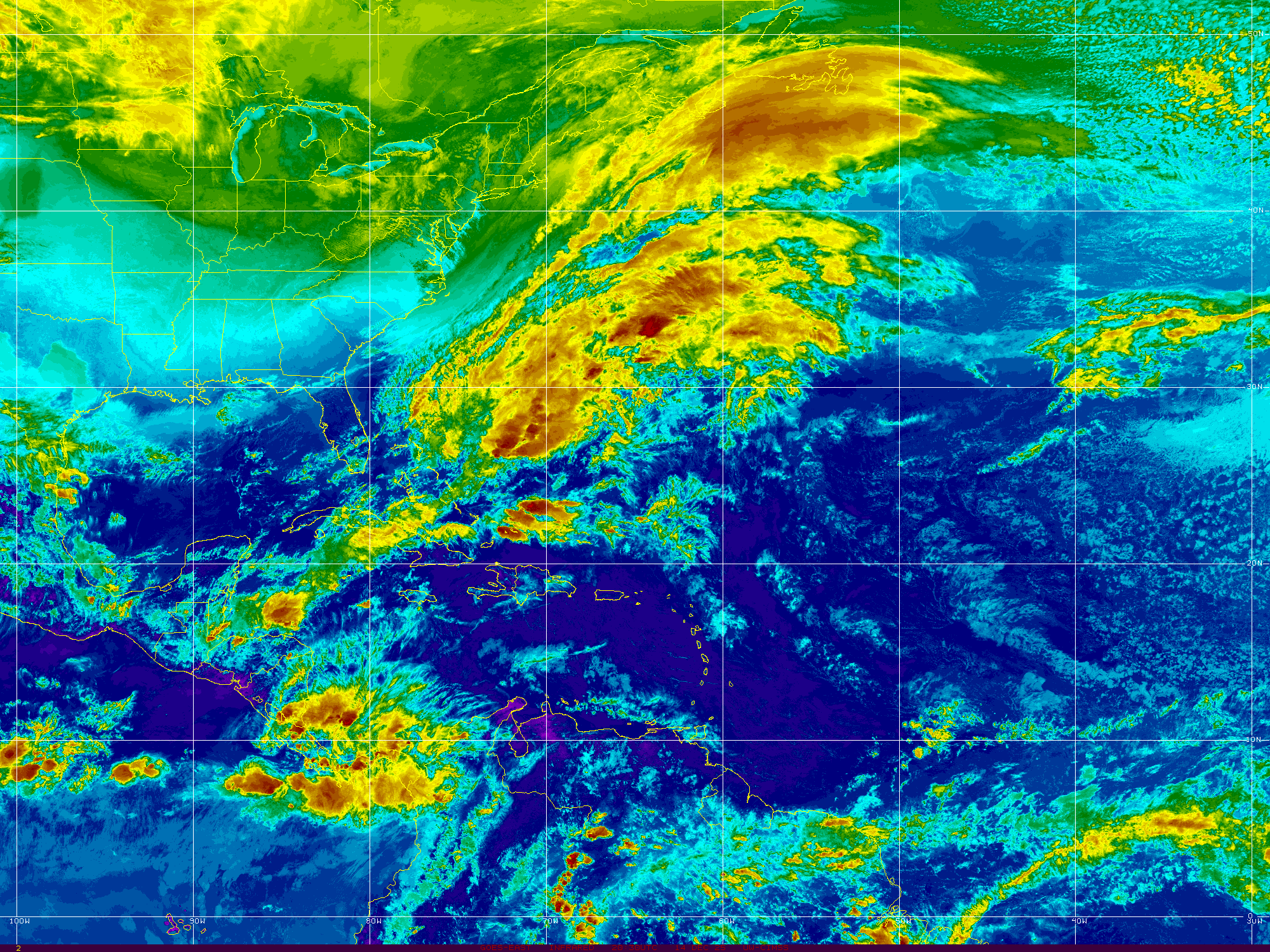
Monday Morning.
Compare and contrast ....
Tropics are there quietly.
Waiting perhaps...
Or not.
Time will tell.
Everyone speculates.
Time will tell.
Michael Ventrice explains Invest 98L
And some thoughts on the 2018 season.

DaBuh dances to his own tunes.

Where would something go if it developed.
Climo and models are our guide.
Edge goes to Climo always.
Especially in odd years such as this.

Odd you ask?
Twisters at high latitudes not Oklahoma.
Flooding in Mid Atlantic on a regular basis.
Subtropical Storms on the Rampage.
Cranky keeps his priorities straight.
Rather than wonder too much on the tropics..
...or how soon winter will be here.
He lives in today.
Not a James Thurber type it seems...

While we wonder on the tropics.
NJ is flooding.
Pennsylvania often floods.
Maryland watches carefully.

Car dealerships.
Gotta move those cars.
Why are they always located in areas prone to flooding.
Raleigh has this problem as well.
Though they move them fast.
What I want to point out today is really what Cranky is pointing out more than anything else. Mother Nature as we like to call her always finds a way. Air flows from the equator to the poles and other times of year the air flows from the Poles South and sometimes it moves West to East and on some days it moves about so frantically that it looks like it's dancing at a rave with a light show and a pounding techno beat and when air moves that fast like a long run on sentence it's hard for anything in the tropics to get going. And, yet misery goes on and happens around the globe be it from a HaBoob or a Flash Flood or a wild Summer Storm on a dark humid evening. I95 floods just like that...1 2 3 and you can't get out of the left lane and high water is seeping into your car. Sometimes an idyllic afternoon outing on a lake in North Carolina can turn deadly when a storm blows up faster than you can get to shore. Misery is always blamed in hurricanes and natural disasters but it took a year for Ellicott City to rebuild and get halfway back to normal and then Mother Nature did it again.
Many years hurricanes form and go everywhere in the Atlantic but rarely make landfall. Wet tropical storms lumber towards the Gulf Coast causing more havoc than a well developed, small, compact Hurricane would have done. A compact Major Hurricane comes ashore in a nature sanctuary in Texas and everyone jokes that Bret was nothing at all. Other times a tropical depression drowns Houston the way Harvey did last year but on a smaller scale.
So watch that loop below and note how everything is a bit chaotic this year and surprises will happen while we watch the North Atlantic to see if Ernesto forms there or it's just a Subtropical Depression dancing in circles until some weather feature picks it up and slings it out to sea towards Europe.

Best song to watch this loop by below.
Song of the day.
I heard Aretha Franklin is extremely ill, possibly gravely, and I was going to put up I say a little prayer for you as a song but I really couldn't as I am so not there this morning. I really don't listen to "old" music much and when I do I only think to myself "so I used to listen to this all the time huh?" I may be crazy but I love how music evolves over time. I'm in love with the shape of you... and you in this case means weather, maps and music. Okay I'm also in love with a few people who mean the world to me. So I'll say a little prayer for Aretha and anyone else out there who needs it. But when I hear this song come on above it washes over me like a gentle rain allowing me to enjoy every drop, every beat at one with the world.
Compare today to last night below.......
Besos BobbiStorm
@Bobbistorm on Twitter if you want to follow me and join in the discussion.
Ps...Oh Philly is flooding. Never count out a hurricane season until late November. Mother Nature usually finds a way to catch our attention at some point and this year it could be at a higher than normal latitude.


Putting this here for a compare and contrast for tomorrow morning.
Note the anomalously warmer than normal water in N Atlantic.

Also note the MDR region is warming up.
So I'll talk on this tomorrow.
You might be reading this Monday.
If so... it's tomorrow.
It will be updated in real time.

It dips down down down...
...then boomerangs back!
Never trust early models.
Then below you can see...
...there's always that one that breaks with the pack.

Let's look at a sat image of 98L

Yes that puff of clouds in the Middle of the N Atlantic is it.
I want you to notice convection in the Caribbean.
Shear remains high but if shear weakens...
Low pressure could form near Florida somewhere.
As they are having tropical downpours every day.
Also note the ITCZ is maintaining convection.
Change is in the air.
Good close ups on satellite imagery below of 98L

I just want to say that you can't really judge what the end result of the Hurricane Season will be from the flurry of high latitude Subtropical Storms going on at present. Even last year during the abundance of MDR hurricanes holding together as they traversed the Atlantic in search of landfall we had Gert up in the Atlantic spinning about. Years ago the NHC did not bother with these storms unless they were intense and on those occasions they tended to be real weather makers. They did not publicly track strong tropical waves or areas of low pressure in the atmosphere and not every small closed low in the MDR (Beryl) nor Upper Level Low was named as was Debby. So to compare now with then is not a level playing field. Often storms were added after the season during a reanalysis of the hurricane season and we never tracked them.
But now days with the tools we have available (see image above) we can track their movement from the NHC or even some bedroom of some kid who has an early obsession with weather and Apps on his iPhone. You really can't compare now and then. It is what it is. Let's see what it is on Monday afternoon.
Besos BobbiStorm
@bobbistorm on Twitter
Labels: 98L, atlantic, flooding, maps., mothernature, music, random, thoughts, tropics, Twitter, weather
posted by BobbiStorm @ 8:30 PM
0 comments



