A writer and a tropical muse. A funky Lubavitcher who enjoys watching the weather, hurricanes, listening to music while enjoying life with a sense of humor and trying to make sense of it all!
Monday, April 08, 2019
Severe Weather in the South Today and Hurricane Season 2019 Waiting in the Wings. Hurricane Gracie Some Hurricane History.
Hurricane Gracie 1959.
Remember that for later please :)
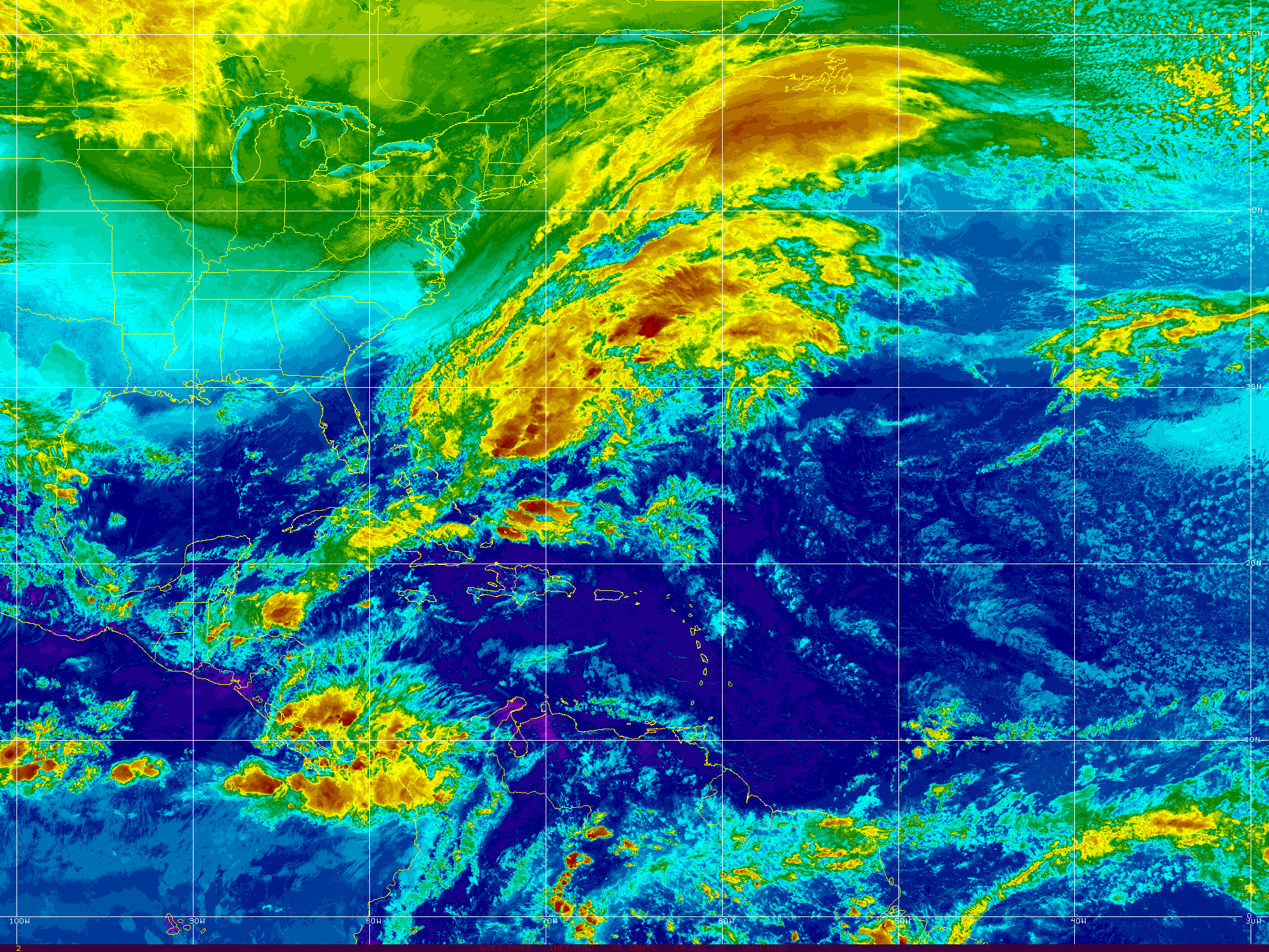
Today's weather issue is shown below.
My best friend says we don't have problems anymore.
We have "issues"
So let's go with that.
Keep your eye on the radar guys.
Chance for severe weather in the South today as temperatures soar close to the 80 degree mark and clash with weather that's not so hot. Everyone in the shaded area is on watch for severe weather that can pop up as fast an a summer thunderstorm or pollen blowing off a pine tree when a helicopter gets too close.
Thunderstorms may pop.
Some may pop violently.
Many hate that graphic above.
Because the word "slight" is hazy....
It makes you think nothing to worry on..
I mean "slight" means barely there to many.
It only takes one tornado to develop...
in the same way hurricane predictions fall ...
...to the wayside when two majors strike the coastline.
It's really stupid for people to say "slight" or "below normal"
Severe weather may happen.
Hurricanes happen.
Speaking of Hurricanes I'm talking on Gracie today.
Gracie was the strongest hurricane since Hazel to make landfall.
That's her eye up there staring down at you.
Gracie was a funny storm in that most people don't remember her unless they are older and live along the South Carolina coastline. Somehow this Category 4 hurricane got lost in the shuffle of the damage from Hazel in 1954 five years before and the overwhelming scope of damage from Hurricane Donna a year later when Donna ravaged a good part of the Eastern Seaboard. Everyone always talks on those early 1960 hurricanes such as Donna, Betsy, Cleo, Flora and yet few seem to remember Gracie. Actually 1959 was a bumper year for major hurricanes and it led right into 1960 that produced the infamous Donna. Check out the video below and wanna add here.... it's possible for us to see similar early season storms form for a variety of reasons.
Worth noting 1959 was a busy season.
A wide variety of small storms and big storms.
Gracie was big... a Category 4 hurricane.
Gracie had one of those tracks a storm tracker loves.
Forms close in and can't decide where it wants to go.
It makes the tracking so much more fun.
Talking tracking as in years ago people tracked.
Now we just look on our App or check online.
Each advisory came out six hours apart.
Three if there were watches and warnings up.
You wrote down the coordinates.
Rushed over to your handy dandy hurricane map...
(all the gas stations and news stations gave them out for free)
And you marked a new dot on the map.
God I love maps.
But Gracie was way before my time.
And living in Florida few people talked about her.
So I forget about her sometimes.
Few who were in her path of destruction forgot.
She was one of the ones that made memories.
This is what video looked like before your cell phone :)
Home movies put to music.
You think we hype storms now?
Wow nothing like news reels.
A "traveling catastrophe"
Who remembers Hugo?
Yeah we've come along way since the 1950s.
Then they were excited to get a good radar picture of the eye.
By the 80s we were watching them travel from Africa.
Traveling West towards the Islands....
... slowly coming together.
Everything was slow then....
Waiting on new coordinates to be released.
Watching each new image from the satellite to come in...
Hugo hit South Carolina like it was the first time in forever.
And in ways it was ....
People moved in from places up north...
... people who thought hurricanes go to Miami I guess.
Miami watched and sighed a breath of relief...
"A Carolina Storm" old timers said.
Great video there...
I remember Hugo.
I remembered Hugo the whole night of Hurricane Andrew.
All of Miami remembered the images from Hugo.
Yet so few remember Gracie.
I have a lot of friends and I do mean friends as some are close personal friends who have been releasing their forecasts for this upcoming Hurricane Season. There's a lot to compare and contrast in them though they all show basically the same thing and that is Hurricane Season is coming sooner rather than later. Coastal cities may have to watch this year as they did last year because it's more likely storms will form close to land vs out in the Mid Atlantic region though that will most likely happen come August and September when the water warms up and the dust dries out.
I'm really not up yet to talk on generalities and mention lots of abbreviations to try and sound all academic and meteorologically intellectual though I'm sure I will as the season progresses. I worked and lived in Academia and it gets boring in ways and it's not like standing on the beach feeling the wind, hearing the howl of a hurricane approaching or standing on rocks or on the hood of a car to get good pictures and data and feel the hurricane up close and personal. If you have not done that on a Florida beach with all the palm fronds pointing in one direction and the trees bending a little as palm trees do you really have not seen a hurricane in all it's glory.
I know Texas gets them and the wind howls as the sand blows and the waves get all frothy underneath the legs the beach house is built upon and yes hurricanes happen in Cape Cod but it's just not the same. Hurricane Donna in New York and nearby regions took down age old oaks and poplars and flooding was the big story. Hurricane Gracie caused "issues" far inland once she was only a tropical storm and that's part of the life process of a hurricane after landfall.
So in a few days or a week or so I'll post the various opinions but like the NWS graphic that says North Carolina may have a slight risk of severe weather they really are trying to warn you that weather may happen. Personally I'm not a big believer in El Nino being a huge factor deep into the hurricane season when hurricanes will happen. I think there's a flip going on and I am not yet sure how much of a flip will happen and whether we go back towards Neutral or lunge towards a La Nina but I do know current conditions warrant concern in coastal cities from hurricanes that form closer in ... much in the way Michael pulled it together closer in and much in the way Jeanne and Frances found their groove as they sniffed landfall and trying to write about whether it will be a "slightly above normal" or "slightly below normal season" isn't doing it for me just yet.
This is not my favorite time of year though Mother Nature is putting on a beautiful show in the Carolinas of Spring color as azaleas are popping and dogwood is at it's prime, pollen is falling and cherry blossoms are in bloom. Tulips are pushing up through the ground at record rate and red seems to be a big color this year. Severe weather is possible across the South. The times they are a changing.
Stay tuned......
Remember while reading lots of articles that the media will put out it only takes one and hurricanes that form close to the coast like Michael or Katrina after hitting her warm water spot there after traipsing across South Florida as a weaker storm (that formed just off shore of Florida) did a whole lot of damage so I don't really want to hear lots of academic discussion on how the water is cooler than normal or that El Nino was officially announced after it had been here a long while and is showing signs of possibly leaving sooner rather than later.
Be prepared.
Pay attention.
Watch your local weather experts.
Follow along on social media.
I watch several sites personally.
I love checking in with Mike because he's always relevant. A man for all seasons :)
Hurricanes happen and so does severe weather ...whether it's a marginal risk or slight risk weather can and will happen.
Besos BobbiStorm
@bobbistorm on Twitter and Instagram. Follow me there for real time information.
Ps... Let's look back at 2018 because I think this season will be similar to 2018 in ways as the pattern has not changed that much overall and because of what I am seeing in April though things can change a lot before September as we all know. September Remember right? Anyone remember Alberto that made landfall early near where Hurricane Michael made landfall late in the season? Remember when Florence formed and was immediately written off by the experts as a "Fish Storm?" and remember when Leslie spun around randomly like a top that wouldn't stop spinning? Remember all the early preseason discussion on why 2018 could be a slower year than normal because of cooler waters in the MDR? Remember when indeed.
Updated......Monday Morning Flooding in the Mid Atlantic Again. 98L in the North Atlantic... the Hotter than Normal Hot Atlantic ... Models Take it South a Bit...
Satellite image
Monday Morning.
Compare and contrast ....
Tropics are there quietly.
Waiting perhaps...
Or not.
Time will tell.
Everyone speculates.
Time will tell.
Michael Ventrice explains Invest 98L
And some thoughts on the 2018 season.
DaBuh dances to his own tunes.
Where would something go if it developed.
Climo and models are our guide.
Edge goes to Climo always.
Especially in odd years such as this.
Odd you ask?
Twisters at high latitudes not Oklahoma.
Flooding in Mid Atlantic on a regular basis.
Subtropical Storms on the Rampage.
Cranky keeps his priorities straight.
Rather than wonder too much on the tropics..
...or how soon winter will be here.
He lives in today.
Not a James Thurber type it seems...
While we wonder on the tropics.
NJ is flooding.
Pennsylvania often floods.
Maryland watches carefully.
Car dealerships.
Gotta move those cars.
Why are they always located in areas prone to flooding.
Raleigh has this problem as well.
Though they move them fast.
What I want to point out today is really what Cranky is pointing out more than anything else. Mother Nature as we like to call her always finds a way. Air flows from the equator to the poles and other times of year the air flows from the Poles South and sometimes it moves West to East and on some days it moves about so frantically that it looks like it's dancing at a rave with a light show and a pounding techno beat and when air moves that fast like a long run on sentence it's hard for anything in the tropics to get going. And, yet misery goes on and happens around the globe be it from a HaBoob or a Flash Flood or a wild Summer Storm on a dark humid evening. I95 floods just like that...1 2 3 and you can't get out of the left lane and high water is seeping into your car. Sometimes an idyllic afternoon outing on a lake in North Carolina can turn deadly when a storm blows up faster than you can get to shore. Misery is always blamed in hurricanes and natural disasters but it took a year for Ellicott City to rebuild and get halfway back to normal and then Mother Nature did it again.
Many years hurricanes form and go everywhere in the Atlantic but rarely make landfall. Wet tropical storms lumber towards the Gulf Coast causing more havoc than a well developed, small, compact Hurricane would have done. A compact Major Hurricane comes ashore in a nature sanctuary in Texas and everyone jokes that Bret was nothing at all. Other times a tropical depression drowns Houston the way Harvey did last year but on a smaller scale.
So watch that loop below and note how everything is a bit chaotic this year and surprises will happen while we watch the North Atlantic to see if Ernesto forms there or it's just a Subtropical Depression dancing in circles until some weather feature picks it up and slings it out to sea towards Europe.
Best song to watch this loop by below.
Song of the day.
I heard Aretha Franklin is extremely ill, possibly gravely, and I was going to put up I say a little prayer for you as a song but I really couldn't as I am so not there this morning. I really don't listen to "old" music much and when I do I only think to myself "so I used to listen to this all the time huh?" I may be crazy but I love how music evolves over time. I'm in love with the shape of you... and you in this case means weather, maps and music. Okay I'm also in love with a few people who mean the world to me. So I'll say a little prayer for Aretha and anyone else out there who needs it. But when I hear this song come on above it washes over me like a gentle rain allowing me to enjoy every drop, every beat at one with the world.
Compare today to last night below.......
Besos BobbiStorm
@Bobbistorm on Twitter if you want to follow me and join in the discussion.
Ps...Oh Philly is flooding. Never count out a hurricane season until late November. Mother Nature usually finds a way to catch our attention at some point and this year it could be at a higher than normal latitude.
Putting this here for a compare and contrast for tomorrow morning.
Note the anomalously warmer than normal water in N Atlantic.
Also note the MDR region is warming up.
So I'll talk on this tomorrow.
You might be reading this Monday.
If so... it's tomorrow.
It will be updated in real time.
It dips down down down...
...then boomerangs back!
Never trust early models.
Then below you can see...
...there's always that one that breaks with the pack.
Let's look at a sat image of 98L
Yes that puff of clouds in the Middle of the N Atlantic is it.
I want you to notice convection in the Caribbean.
Shear remains high but if shear weakens...
Low pressure could form near Florida somewhere.
As they are having tropical downpours every day.
Also note the ITCZ is maintaining convection.
Change is in the air.
Good close ups on satellite imagery below of 98L
I just want to say that you can't really judge what the end result of the Hurricane Season will be from the flurry of high latitude Subtropical Storms going on at present. Even last year during the abundance of MDR hurricanes holding together as they traversed the Atlantic in search of landfall we had Gert up in the Atlantic spinning about. Years ago the NHC did not bother with these storms unless they were intense and on those occasions they tended to be real weather makers. They did not publicly track strong tropical waves or areas of low pressure in the atmosphere and not every small closed low in the MDR (Beryl) nor Upper Level Low was named as was Debby. So to compare now with then is not a level playing field. Often storms were added after the season during a reanalysis of the hurricane season and we never tracked them.
But now days with the tools we have available (see image above) we can track their movement from the NHC or even some bedroom of some kid who has an early obsession with weather and Apps on his iPhone. You really can't compare now and then. It is what it is. Let's see what it is on Monday afternoon.
Thoughts on 2018 Hurricane Season on a Rainy Day In Raleigh. Flooding in France. Musing.
The poor statue is under the weather today, hip high in flooding as the river Seine is on the rise. It's raining on the East Coast today. It would be a slow boring, monotonous ride on the Silver Star today if I was on a train North Bound.
Some personal thoughts on a rainy gray day in Raleigh. That almost rhymes though it's a rhyme I didn't intend to make. I did want to post some weather thoughts today, however I warn you this is more of a personal post so I may ramble a bit with an overall theme of a gray winter day.
Today was the day I wanted to go outside somewhere bright and beautiful and breathe fresh air. I've been sick or as we say in the business "under the weather" and I really would love to have walked around outside in the Carolina sunshine. Seems I'll have to wait until Wednesday for real sunshine or at least tomorrow for the rain to take a breather. I'm comfortable and cozy here in the room with a candle burning and TWC on mute. If I hear them talk about the "deadly flu" one more time I'll turn them off and just play some music.
I'm really doing better than I was the other day. No fever and coughing less and sipping the horrible tasting Traditional Medicinal Tea that really works but I dislike fennel and licorice and both are the main ingredients. I suppose sometimes you have to take things that are good for you even if you don't like the taste. I added a heavy Trader Joe's fruit beverage that has purple carrots in it and masks the taste just a bit.
I started weeding through my gmail that has now reached over 587 letters to read. If this was my old library job I'm pretty sure I'd weed the whole account, however it's the vehicle I use to blog so probably not. The new world we live in reminds us of everything we ever typed. The horrible eye shadow color I looked at and didn't like shows up in my advertisements; Facebook offers me deals for it. I know you are supposed to search incognito but really the struggle is real. I delete and unfriend and unsubscribe and yet they show up eventually back in my gmail. I may have to resolve this sometime soon after kicking the flu or a cold and then catch up on all the things I didn't do while resting and fighting the flu or cold or whatever it was that put me under the weather.
Speaking of weather.... It's kind of boring for me here. It's kind of boring everywhere. It's basically just "winter" and there are no snowflakes insight on my 10 day weather forecast though a few may sneak in on the tail end of a cold front on Tuesday. A few as in I'd probably miss them while going to the bathroom or boiling water for a cup of tea.
A bird is singing outside. I guess this is a break in the rain. The bird is singing loudly.
Paris is under water today and I do not mean Paris, Texas. Paris, like Charleston, has a history of flooding. We don't hear about it often unless it makes the news or someone with an agenda of Global Warming decides to post a ton of pictures as if Paris never flooded before.
That said the pictures are a vivid stunning reminder that when we live near a river we are often at the mercy or Mother Nature even without a hurricane or winter snow melting.
Years ago storms hit without warning and there was no way to predict a little bit of flooding would turn into an epic event washing away small towns. On days when it's quiet and I'm not rushing about things hit me in a different way. The realization of something we take for granted such as the five or ten day forecast. People argue on the models and complain when the forecast is off, however there was a time when the models weren't there to debate. I have 2 different Farmer's Almanacs this year because I travel a lot and they make for easy reading when you can't charge your phone on an airplane. One has been spot on with weather and the other has fallen behind seriously in accuracy. Not that I really expect it to be right at all but it's worth noting both snow falls in Raleigh were noted in one of the Almanacs perfectly. Glad we have the models.
So as for today's weather. The moisture is coming up from the Gulf of Mexico. This has been a continual theme this winter in the South and East and I'd expect this is going to continue as a theme as we move into the 2018 Hurricane Season. I can give you many reasons I believe this will be an equally busy hurricane season as the last though tracks do not often repeat but have general similarities. More of the same as long as we have this current set up.
So take this time to review your priorities and properly prepare for the 2018 Hurricane Season. It's that simple. And, if you live where winter weather has reached you earlier this winter than I suggest you don't think winter is over because the usual January Thaw set in as we all know February blows in a fierce reminder we are still dealing with winter a bit longer.
Again we have models and our long range forecasts are better than they were back in 1978 when much of New England was blindsided by a blizzard of epic proportions.
Also the much aligned web makes it so much easier to assimilate that information out where it needs to go and in today's world that means multiple social platforms that are seen on your phone the moment you wake up to give you the most accurate information for what you may expect on any given day. Years ago you knew it was winter and it could snow. It was basically that simple. Yes we had satellites but we were still in the infancy of modern day forecasting. If it wasn't in the newspaper or you missed the nightly news unless your crazy Aunt Martha called you up to tell you she heard there might be weather you might have missed it until the snow began to fall in epic proportions.
I dislike hyping weather events but some were epic. The winter of 1977 - 1978 was epic and part of a pattern that went longer than one year. Hurricane seasons can be that way too. The very busy hurricane season of 1995 was followed by 1996, the very busy hurricane season of 2004 was followed by the memorable 2005 hurricane season. I'd venture to add the 2017 hurricane season will be followed by a busy 2018 hurricane season. I'll elaborate on that more in upcoming blogs but just putting that thought out there. So while complaining on the strong winds in Miami this week know they only will get that strong and no stronger. It's just wind not a hurricane. I can't promise though on what will blow through in 5 or 6 months from now as the Gulf of Mexico could produce early trackers.
Stay tuned.
Besos BobbiStorm
@bobbistorm on Twitter
Ps... Don't you just love these. They are great set to music. Still trying to learn the nuances of the crypto meaning behind these long loops. Can't wait to see how they play out during the hurricane season.
It occurs to me today that Joni Mitchel was yesterday's Taylor Swift in her way. I liked a few of her songs in retrospect but was never her biggest fan. She was a bit before my time and when I go "there" I think Carole King and Judy Collins. But the song fits... we could round and round in the circle game.
The seasons they go round and round and soon we will be tracking hurricanes again.
Location: Miami, Raleigh, Crown Heights, Florida, United States
Weather Historian. Studied meteorology and geography at FIU. Been quoted in Wall Street Journal, Washington Post & everywhere else... Lecturer, stormchaser, writer, dancer. If it's tropical it's topical ... covering the weather & musing on life. Follow me on Twitter @ https://twitter.com/#!/BobbiStorm