Hurricane Harbor

A writer and a tropical muse. A funky Lubavitcher who enjoys watching the weather, hurricanes, listening to music while enjoying life with a sense of humor and trying to make sense of it all!

Thursday, July 12, 2018

Somethings to Talk About Tropical and Otherwise. Chris, X Beryl Trying to Make a Come Back. Midwest Wild Weather. Cold Fronts Early. African Wave Train.


You notice two things here above.
Deep reds and oranges nearing the Great Lakes.
A large circulation off of Africa ...
..and a wave behind it coming off today.


Waves shown above.
Two very healthy waves.
Saharan Dust is waiting for them.
Classic for this time of year.
No not really...
...we are ahead of schedule this year.
The waves are actually healthier.


That's a healthy 

Put it all in motion.

hiatlsat_None_anim.gif (768×496)

The waves in the Atlantic are mentioned below.
Also mentioned are the high winds in the Caribbean.


Going to point out some things this morning and then move on to do some things I need to get done. I suppose we could name today's blog "Somethings worth watching" :)

When looking at the wide view of the Atlantic and it's associated land masses it is very hard not to notice the huge wave coming off of Africa. There is actually another huge wave axis that moved off of Africa recently that is maintaining convection on the South side of it much like Beryl and most strong waves do this time of year. They, like people, find their energy where they can get it and work with what they have to get where they are going. Some people like regular old American Coffee such as Folgers or Maxwell House, others like Nespresso like me...  some drink Coffee, Tea or even Red Bull. There are some rare people who don't do any form of energy or drink and they drink water. Well, water is the most beneficial energy drink any of us can drink and coffee, tea and even Red Bull start with water somewhere. Water in the tropics needs to be the right temperature to get tropical convection blowing and rolling so that it makes it's way across the Planet to ours side of the world. Each wave that dies out in the East Atlantic puts moisture into the atmosphere readily available to the next wave behind it. Waves are it seems "team players" having each other's back and lending support even when they aren't going to make the trek themselves.

The end result of this process is that when the Atlantic heats up a bit more and the Saharan Dust wanes some as it is prone to do later in the summer as we approach the peak of the Hurricane Season some wave coming off of Africa with a great looking low pressure center attached will develop and become a problem. Even somewhat slow years often produce one or two dangerous, way too viable hurricanes. Sometimes they develop close in and other times they take their time, getting dangerously closer to the Islands and then develop. Every year is similar, every year is different yet the one constant is Hurricane Season really gets going later in the summer. My one problem with this year is that it feels as if we are running several weeks ahead of schedule. Time will tell how this plays out.

As for Chris it is one hell of a storm. I really cannot say enough about what a tremendous feat it achieved by even BEING a very strong Category 2 Hurricane in Early July over marginally warm water, with dry air from the nearby cold front and high pressure system that built over him trapping him below where he looped and looped yet did not die out. Had that front not been in early July (also rare) who knows for sure where and if Chris would have made landfall somewhere. Thirty Four such storms  have made landfall in North Carolina since recorded history and Chris most likely would have been thirty five if it had not paralleled the coast and made landfall further to the North. Chris was a real fighter and it's worth noting that even though it stayed off our coast it didn't ignore land further North.


Jim Williams has a way of predicting where hurricanes will go.
He makes a yearly forecast.
His forecast last year was dead on for hurricane tracks.
This year his forecast is so far on the money also.

Sable Island was his #1 pick.
You can check out more on his website.


2. Chris still recognizable 
Spread out at a high latitude.
Dangerous still.


3. Cold front moving off of the Carolinas.
Associated weather...
Early July.

4. Remnants of Beryl.
Nothing there yet.
But we are watching.
50/50 odds still by NHC
Chris left Beryl cooler waters.
Let's see what XB has under the hood.


Keep watching.

Lastly the wave off of Africa.
A wave train forming.
Needs to be watched in the long term.


Again these are the players above.

Midwest storms.
Chris.
Cold front near OBX
X Beryl
Wave Train by Africa.


Now a look around Twitter at what people are talking about and why you should think on these meteorological events.


Cranky is concerned about Chris.
Wanna know why?
Cause even downgraded to Extra Post Whatever...
It's going to be one big blow.
He shows that with great maps.
Good solid discussion.


What an amazing set of pictures.
Side by side.
Inspired Cantore to wax hyperbole today.


James Taylor needs to write a song for that one.
I've seen snow and I've seen tropical rain.
16 days apart.
Amazing.

DaBuh is watching the African Wave.
Interaction with SAL


DaBuh is more often right than wrong.
Either way he explains the pattern.
Presents the possibilities.

Wicked Weather in the Mid West.


Weather Nation covers weather.
Tornado near Red Lake Minnesota 
Again all the tornado chasing action...
...has been moved to the North this year.


Is that a sunset and a funnel cloud?
Wow. Epic beautiful.


And last but very not least.
Mike and his daughter have picked a winner.
You can go to Facebook and watch the video.
Do it! 
You might be the winner of his drawing...
Missy was the winner.
I always loved that name.

I have a confession to make.
Knowing Mike like I do..
I wondered if he was rating luncheon meat :(


No.... those are tickets for a raffle.


One thing I have to tell you is Mike is very genuine and real. He is who he is and he's a good father to both his daughters. The daughter above plays softball (all positions except catcher) and many of his Spaghetti Model Page Fans have helped contribute for her to go to play in Panama City, Florida. Mike donated an incredible prize for people who helped and he is extremely grateful to his wonderful fans. Those are his words, he has often waxed poetic on how wonderful his fans are and the people who talk on Facebook and discuss weather with him while watching his Facebook Live. He's inspirational in ways because he truly finds ways to enjoy life; maybe it's the moonshine...

That's it everyone. Have a wonderful Thursday and keep an eye on the weather always.

Besos BobbiStorm

@bobbistorm on Twitter 


That's me... a photo I took while out storm chasing with my daughter in New York City. Yes, NYC gets crazy summer storms (that was during Hurricane Arthur passing off shore) and sometimes in years such as this when all the energy is way up north they really do walk the line between waiting on cold fronts and winter to begin and saying goodbye to Hurricane Season. I could be wrong, I'm just pointing out the pattern and this year's pattern of Tornado season taking a Northern Vacation to Wyoming and the Dakotas and Minnesota, extreme flooding and rain from Pittsburgh to Maryland and even the appearance of a hurricane off the East Coast in July all point to possible tropical problems for the Mid Atlantic later in the Hurricane Season. 


Ps Some music history.

Labels: , , , , , , , , , , , ,

Wednesday, July 11, 2018

Hurricane Chris Out to Sea. Beryl Remnants Remain a Possible Problem. DIY Ideas and Hurricane Prep. Busy Year So Far and It's Early. Do You Have a Hurricane Plan?


HURRICANE CHRIS


Only cities that need to worry about wind from Chris.


Looks good...doesn't it?
Far off shore.
Not bothering Bermuda or East Coast.
Just cruising along NE at 22 MPH


Put it in motion.

hiatlsat_None_anim.gif (768×496)

Hurricane Chris is churning up the waters of the Atlantic far away from the Atlantic coast to have any impact other than high surf and small craft should probably be aware it's there. If you have a small craft you are usually aware of the weather as it's the first thing you need to check before taking the small craft out into the water obviously. So even though you can go online and see these stunning visual images of a big hurricane off the coast know it's staying off the coast. 


The truth is unless you live on Cape Cod you aren't worried about Chris and they aren't really worried as they have winter storms that are way stronger than hurricanes. That's what they ALWAYS tell me, my friends up in those parts. "Oh we have real Nor'easters stronger than hurricanes" and yeah that's because they die before they get up to your cold waters. Kind of clueless in ways as what they often experience is not what people experience on the Pacific Islands that are lashed by 185 MPH winds or the hell that Hurricane Maria created when it sandblasted an island in the Atlantic before going on to disrupt life in Puerto Rico where life is still being put back together. Yes, I know your Nor'easters are awesome but nothing compared to a slow moving West Indies Hurricane. Nuff said on that. 


So in truth no one really cares that much about Chris other than from a visual and academic perspective. In truth last night it looked to be a Major Hurricane, Cat 3 yet was kept at Cat 2 with long discussion explaining why they kept it at Cat 2 strength when it appeared to be a Major hurricane. For the record books it was a Cat 2 with a Cat 3 appearance. What's 5 MPH between friends? It's an impressive hurricane here too early making 2018 a now busy hurricane season with good ACE numbers so let's store those headlines about a dead hurricane season away and put them in a file named 2018 Hurricane Season. Yes, some people actually have files; some keep newspapers and others keep intricate folders on their computers. Hurricane Trackers and Chasers should really be renamed for that they truly are and I've done it so you can include me in for my own chasing days. We are Hurricane Stalkers. That's the real honest way to put it, yet it's not so politically correct so we call ourselves "Storm Chasers" but really people are just stalking the storm trying to touch it's energy, understand it and get pictures of it to store away in their cache of memories.

And, when Chris goes out to sea........ people look elsewhere to see what's next.


So what's next? 

The remnants of Beryl remain a question. I'd use the word quandary but I've used that already so let's just say it's a big question. Currently at Noon it's still 50/50 and you ask why I bet? Yet there is a huge about of convection over a large area traveling en masse off the East Coast following in the wake of Hurricane Chris. Waters some what cooler than they were before Chris visited and not very warm to begin with in July. Well, warm enough for something but not for real trouble to happen. We are on the C storm looking for the D storm in early July. If this continues we will need to worry about hurricanes that play peek a boo with cold fronts and high pressure systems in this part of the Atlantic as those powers that be often bring real trouble to the coastline; trouble not just high surf and riptides.

So Chris exits stage right.


Models have been playing with Beryl's remnants.
The presence of a storm of any kind...
...keeps the ante up and the NHC is monitoring it.


Note on the 5 day that X is orange.
The 2 day is shown below.
You can see the ripple in the winds on Earthnull


Models below show the weak concern.
Weak as in currently nothing is there.
But in general the water is hot in the Bahamas.
And it's quite warm just offshore.
The Gulf Stream is always warm.
Especially in July.


Note the 3 model slivers below show two things worth noting. One is the presence of the remnants of Beryl trying to form into some sort of closed low. Those remnants actually loop about much like Chris did for a day or two. Chances are only 50/50 and it's worth remembering Beryl was always enigmatic so expect more odd behavior if it does really try and form. Also note the strength of the high to it's right over the Atlantic.


As models keep throwing out this close in solution.
The NHC will continue giving it medium odds.
50/50 in the 5 day.
It would be pretty amazing for X Beryl to pull that off.

Elsewhere........
A wave near Africa exits and enters the stage.
Short window to stay alive.
But so far not expected to develop.


Note Global Hazards Map highlights the area still.


Lastly leaving you with some Hurricane Prep reading.

I don't usually click on "promoted links" 
But sometimes it's worth looking.
This is actually a very good link.

May try this to see if it works.


Besides the light I imagine it would scent the air.
Without power the air gets stale...
..so you might want to check this out.

Hurricanes are happening this year.
Despite cool water by Africa or EL Nino later in the year.
We have had 2 hurricanes by early July.
Worth checking on what you would do...
...if a hurricane came to visit you.
Unwanted guests are the worst...

ACE is happening.


It's worth getting a Hurricane Plan.

If not now when?


Better now than later.
Heard a saying last night.
If you have the time to do something....
....do it now before time runs out.

Besos BobbiStorm
@bobbistorm on Twitter

Do you really want to be that person?

Give it time.
It's really funny.
Been there trust me.
You don't really want to be that person...


Not a loaf left.
Canned tuna and meat gone too.....

Hurricanes Happen.
Even in years going into an El Nino 


Labels: , , , , , , , ,

Tuesday, July 10, 2018

Updated! HURRICANE Chris Finally Making His Move ... EYE POPS OUT.. NE at 9 MPH Recon Going In to Verify Hard Data Before Upgrading Chris To Hurricane. X Beryl Still A Player. Models Doing Kinky Things. Wait Until Next Model Run NHC says 50/50 Odds on Beryl Again. Life Goes On and On and On... Maria About to Slam Into China as a Dangerous Cyclone.

Hurricane Chris
85 MPH
980 MB
Moving NE at 10 MPH
2nd Hurricane of 2018


Beautiful and impressive.
Also safely staying out to sea.


Recon has found Hurricane Force Winds in Chris.
Satellite imagery shows that as well.
A well defined Eye ...
... better developed Chris.
A beautiful Chris.


Boy does that show it all. 
Chris wrapped convection up in all quadrants.
No more bottom heavy Chris.
Developing a nice tail too!


This image shows the steering currents.
The new trof pushing down on Chris.
Protecting the USA
Chris may make it to England.
After first doing the Canadian Maritimes.
That green satellite above is from their site.
Phil Ferro in Miami giving this thoughts.
And showing us an intense up close image.
The EYE of Chris.


Where do we go from here?
Things are pretty much set in stone.

Wind Probabilities are shown below.


I'll update later tonight.
If you haven't read...
...please do.
You may learn a lot.
Or at least be entertained a bit.

:)


Still waiting on recon.
Adding in a few things here.
Maria is about to make landfall in China.
Why do I care?
Continue reading the blog you'll know.
Over in China...


Great video of Jim Edds nailing the eye of Maria.
And enjoying the sunshine.
Yes the sun can shine in the eye of a Hurricane.
Been there... really... awesome experience.
Well if you get back to safety fast and live to tell about it.
Back side slams you fast and quick.


And there's the sun shot he posted.
It's in the video ...


As for Chris...
Looks incredible but waiting on recon.


Still a tropical storm.
Not a hurricane yet.
That will change.

EXCELLENT DISCUSSION

Salient Points.
Waiting on recon to make the call to Hurricane Status.
Finally moving though.


Cone below


Wind Probs.
Currently Cape Sable in the cross hairs.


Satellite loop below.


hiatlsat_None_anim.gif (768×496)

Chris clearly visible to everyone.
Remnants of Beryl also visible.


latest72hrs.gif (947×405)

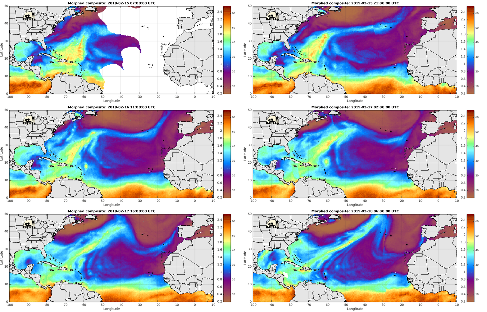
I post this site often as it shows the whole basin and the wide range of influences that have an impact upon both waves and named systems. Blue and dark purple are dry air and orange and golds are moist air. The circular while area that pops out where Chris is ...is in fact the "eye" center but we are waiting for recon to collect the best hard data before an upgrade to Hurricane status it seems. We will wait as having patience is a key part of tracking hurricanes. Nothing good ever happened immediately in this realm of the world and storms that rapidly intensify and make a run for the coast the way OJ used to cream the Dolphins carrying the ball to the End Zone for the Buffalo Bills is an example. Then again if he's carrying your ball it's all good but there's always another side to that story and stories evolve over time as we know. Add in the Labor Day Hurricane of 1935 that blew up in the Bahamas fast giving very little lead time to the weather team that promised to get the Vets off of the Florida Keys if a hurricane happened.


Note the words.

"with little advance warning"


Thankfully in today's world that no longer happens.
We have come so far.
We stand on the shoulders of meteorological giants.

Now let's look at today's tropics.

Posting the 5 AM.
You can compare and contrast with 11 AM.
Chris barely 2 MPH N.
Now he's moving way faster.
With determination.
Compare to 11 AM above.


 NHC was generous at 5AM with that forward motion.
That changed finally....
Things change.
Remember that.


Atlantic Ocean.
Chris is easier to find than Beryl ever was...
Chris can even be seen on long range radar.
Well the Western part of Chris


Close up views of Beryl below on Earthnull.
Way down below.
Chris below.


Note there is more bulk to Chris in his legs than his shoulders.
That will change.
There is high pressure to his North pushing down on him.
That will change.
Below ...
...remember the Dvorak I used to show all the time?


Great way of slicing and dicing a storm from far away.
Intensity on the bottom.
As always Chris has been bottom sided.
That will change.
Beautiful color image of Chris 


Oh wait what is that an odd looking bird below.
An Ibis?
A parrot?
Is it a bird?
Or a plane?
No....... it's X Beryl.
Remnants of Beryl.
Still crazy after all these years.
X Beryl will change too.
Another view.


But you thought Hispaniola would kill it?
Think again.
It's gone but not gone.
Tho easier to see now than when it was a Cane.


Is Beryl alive?
Can it come back?
NHC deserves awards for these graphics.
Love it. Really.
Not being sarcastic.


Yes I know I have a strange mind.
It's an acquired taste.
Note 
X Beryl has a 50/50 chance of redeveloping.
Say it ain't so.

In 5 Days.
50% chances.


Models are playing with it.
And I do mean playing with it.

The image below can be found on Spaghetti Models


WHOA....
Say it ain't so.
This is why I don't hug models.
I hug people ;)
No that's not an old graphic for Jeanne
Could a storm do that?
Yes, that has happened.
Don't bet on it happening.


Remember when.......
Jeanne bounced off of Hispaniola.
What doesn't kill it makes it stronger.


Again could that happen?
Anything in theory could.
But no it won't. 
Whatever happens will happen.

Love Dabuh's Tweet this morning.


Dust in the wind indeed.

Last night watching Earthnull.
A good tool. 
Think on that word.


So I asked Cranky.
What would cause that disturbance in the force?
I respect him and he always has an opinion. 
This is what he said.


This morning the kink in the wind has moved a bit.


Ignore my little marker from the pointer.

This is what I want to say about Beryl. Without good satellite imagery we would never had known she existed. It's possible the 1935 Labor Day Hurricane had a small signature that would have been picked up on satellite imagery today and models would have run and hopefully one of them would have caught the Rapid Intensification and given South Florida a bigger heads up than we had in 1935. I have always had problems believing the plot line that it just POPPED UP OUTTA NOWHERE. It was a very small system and it rapidly intensified as small systems are want to do. Beryl always had a LLCC and it also had a mid level that hung behind that became more noticeable as it fell apart. Naked swirls are beautiful because you can see the bones of it suddenly. Not going to show nudes of Marilyn Monroe but you get the idea.  Go back into my old blog on Beryl and you will see what I am talking about. 

Time will tell.
I would not count X Beryl out.
Beryl could make a come back.
I kind of have this running in my head...
.... more than any one model.


:)

Moving on... 

In the Pacific there is Maria.
That name.
Retire it please.
And every variation of MARY.
(love the name Mary.
My Grandma was named Mary.
.... fill in the blank...
(I won't say it Fishing is already laughing)


Easy to see isn't she.
Oddly off the bump of China...
..that looks like Chris off the Carolinas.
Jim Edds who I consider a friend is there.
You can follow him on Twitter.
He does a great job.
A very sweet man.


@ExtremeStorms  on Twitter


Track and Maria below.


Way better than the five day cone five days ago.
Proving the point for all basins.
Better to be the center of the 5 day cone...
...than the 3 day cone.
Because 5 days ago Shanghai was the center of the cone.


This is pretty much my home screen these days.
My youngest son is in China today.
Hopefully on a train to Beijing from Shanghai.
I'm not sure where my oldest son is..
..NYC I think this week.
 In a recording studio probably.
My life gets more interesting over time.
I'm making a Mango Smoothie for lunch.


Elsewhere.... life goes on in the tropics.
Waves roll off of Africa.
Areas despite water temps are favorable.
Early this year.
Will winter come early this year I wonder?


I'm adding this and then I'm done for now. I do this because I love it. I am a writer. My work has been published in many places and I have collaborated both on tropical research :) as well as other literary works in ways I will not explain. It's my story to tell and I'm not telling it. I'm just a girl who loves weather and maps and writing. I love my family, I love my friends and I love communicating. If anything I write or put out here helps someone to better understand a storm or be less afraid of being in the cone or gives them tips to prepare for a hurricane zooming to their home than I left the world a better place and my job here was done well. I'm kind of like a storm in ways. I've been stalked in an oddly good way much like a long tracking Cape Verde Hurricane that provided much enjoyable tracking over a long time and then was researched way after it was gone off the maps. 

When I was little I didn't really understand hurricanes, but I knew I was intrigued by them. I had this odd theory that after hurricanes like Donna moved off to Europe they spent their winters there and then circled back to come across the Atlantic Ocean again during Hurricane Season.  I was really, really young. My mother explained no that was not how it happened and went out and got me a tracking map from the local gas station or grocery store and showed me how to track hurricanes. My neighbor was a hurricane hunter, no wait his mother lived next door and his black and white photographs adorned her walls as she was extremely proud of him. In High School I tracked with my friend whose father was a navigator on the hurricane hunter planes. I dated a guy who worked at the NHC as an Intern in his spare time while keeping his GPA way above 4.0. I know because my best friend kept track of his GPA ...why I don't know. She was Salutatorian of her High School Class graduating a year before me leaving me in charge of the remnants of our high school click. Always beware of Salutatorians as they usually miss the Valedictorian status because while they are keeping their grade point averages up as they often are more socially active in other ways .... who knows; just a theory.  Now days they are doing away with their speeches as everyone is on a level playing field but some people just have a higher GPA. Okay, I remember my best friend Linda enjoyed writing that speech but she was a writer. I drove my counselor crazy as she pushed me to get better grades than I was already getting while being extremely socially active and being officer of a few clubs. I asked her why I should try to get better grades when I had great grades already while doing not studying that hard and doing everything else. She shook her head and walked away rolling her eyes. I get it. I roll my eyes a lot now. Probably explains my headaches I've had since I was about 17. That never changed. 

So..........if you are here still reading this Thank You. It's apparent to me that blogs are going the way of the AOL Chat Rooms and Message Boards and I have checked Snapchat every few photos I posted to see if my younger son has checked in. I know I can't eat a good sushi roll without sending a Snap to my youngest daughter....  If I type in "INS" into my browser it takes me to my son's Instagram account. He's a great photographer but he's finishing a Masters in Architecture. My older son is in the music and graphics business; he produces Jewish Music and manages artists and their concerts they give around the world. His watch is often set to Miami time and "Benny Time" which will make sense if you are a Jewish Music fan.  Both my children's grandmothers were artists. Art is big in my family. I write. I dance. I watch hurricanes and love maps. My name is Bobbi. What's yours?

Besos BobbiStorm
@bobbistorm on Twitter

Ps... I don't know what makes people today argue so much that they need to take a side vs just discuss different aspects of meteorology and life. Whether it's politics or models or late night arguing on weather they are always arguing. I mentioned to someone once I like Cinnamon Gum and he responded "OH I like Peppermint" and he does popping peppermint candy in his mouth. I like Cinnamon. It sounds good. Cinnamon like an Edna Ferber Novel of a different name and a cute boy I liked used to run across the street, leaving the class while the teacher was out racing across the street not getting caught to buy me cinnamon tooth picks at Dixie Rangers Bike Shop (long story) before getting back in class without getting caught. It was a writing class. And the beat goes on... 


:)


Labels: , , , , , , , , , , ,