Hurricane Harbor

A writer and a tropical muse. A funky Lubavitcher who enjoys watching the weather, hurricanes, listening to music while enjoying life with a sense of humor and trying to make sense of it all!

Tuesday, January 07, 2020

PR Earthquake - Spring Like Severe Weather Outbreak in Winter in South - Winter 2020


Puerto Rico just can't get a break.
Well the Earth is breaking...
...rocking and rolling today.
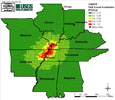
Yes, PR is earthquake country.
We hear about Hispaniola more...
...but you got mountains you have earthquakes.
Fault lines run through the Caribbean.
Hurricanes attack the Caribbean.
Jamaica has had earthquakes and hurricanes together.
You learn a lot from studying history and geology.


Here's your general video below.
It began yesterday and continues on today.
Aftershocks continue today.
Hurricanes don't have aftershocks.
When they are gone... it's over.
And you clean up.
Earthquakes don't work that way.


It goes without saying they need help.
Charity and prayers.
Or give your favorite charity there you trust.

I've been back in Raleigh getting back into a routine, unpacking, cleaning up, doing laundry and trying to remember where I was before I left. For all the journals I keep I really should have one that says "After Traveling ... Get Back on Track Fast" as every wonderful trip means coming back to the every day routine and research I work on as well as every day routines. I have a trip to Seattle coming up but the date is not set just yet. Miami, Monsey ... am I really back in Raleigh? Yes, and to be honest I like being home in Raleigh these days. The air is cooler and it's easier to breathe yet today we are hovering between "nice ... feels cold" and "why does it feel so raw today?" and I know why it's because rain is moving in and the skies are gray and it's a North Carolina Winter Day when you feel if it's this cold it should snow but the cold front is dry this time so all you get is cold, winter rain.

It's been an odd and interesting winter but so far snow has had a problem finding it's way to the Mid Atlantic or the South while sliding along just North of NYC and attacking New England as to be honest Winter is supposed to do because that way we have small towns covered in snow that look like a Greeting Card promising a Winter Wonderland. When you live South of the Mason Dixie Line you got to be realistic about how much snow you are going to get in any given Winter but still it is NORTH Carolina so the chances are there ... somewhere... sometime...distantly down the road. I have a friend in North Dakota, I miss that friend... should I go visit her?  With every week that passes things change subtly and supposedly change is in the air...

clt_None_anim.gif (768×496)

To be honest.... the mountains get some snow.
But everyone else got rain.
Speaking of rain in the South.
The set up for the next cold front....
...and abundant tropical moisture.
Is creating a Spring Like Set up...
No it's not Spring... 
We haven't had winter yet.
But it's that sort of set up.
Progression of fronts....
...and a flow from the Gulf of Mexico.
Watch the next one down the road..

Being honest I am not 24/7 watching loops.
I watch... I do a model or a two.
I read a bit from people I respect.
Then I try not to obsess.
Not my neck of the woods... I don't care.
Being honest.. weather is locational.
Watching other people get snow is not fun.
Would @icyclone chase a thunderstorm?
Because he's bored and there's no Hurricanes to chase?
Nah... neither would I.
I love it all ...don't get me wrong.
But I want the weather ... I want snow.
I'm less a dreamer or watcher as much as doer.
And if I can't "do" weather today the way I want.
I'm probably doing something else.
I do have hobbies ya know...

As is the earthquake as it's in our Tropical World.
Wrong Earth Science but Mother Nature does her thing.
Luckily we don't have the fires they do in Australia.
Somewhere Mother Nature is always throwing..
a temper tantrum.

You can watch the forecast below.
The reliable forecast.
Short term vs long term.
Fronts are making it into Florida.
They are making it into North Carolina.
But for now we be getting rain not snow.

allfcsts_loop_ndfd.gif (799×559)

The middle of the country is getting RAIN.
Insert song "Rain on your wedding day"


That is a lot of rain.

Checking with Spaghetti Models
(which I always do every day)


Winter with it's snow is way up North.
But it's cold in North Carolina today.
Then it warms up to "why am I here?"
I stay here hoping for now.
No snow I should hit the road.
Myrtle Beach Hotels are sending me ads.
"Please come...we are open and cheap!"
Basically that's what they say... 

To be honest I'm tired of hype.
A lot of hype on the news lately.
A lot of hype in the weather.... 
When you have a real strong WINTER pattern.
You don't need hype do you?
It's there... in your face... happening.
Like "Oh my gosh" ;)
Wait a few days you'll see.
Today we have a thin sliver of a front.


I won't say what that system looks like to me.
Use your imagination.
But you see the real problem is the next one.
Down the road still.


Image above from Crown Weather.

You can subscribe to www.crownweather.com
He goes into great detail.
He's good!
That graphic is from yesterday's email.
Become a subscriber and you will get information.
Not hype... or symbols on Apps that come and go.
But the real deal... 

On Twitter.......


Cranky is also the real deal.
If you can understand his maps.
You are lucky because they are so good.
I can, I love them.
I love maps...as most of you know.

Everyone has their own needs.
Everyone likes a different style.
Good meteorological maps are always in style.


As for me I kind of feel like this today.
"That's the system now I'm outta here..."
Occurs to me that's a Mars symbol.
I told you .. I have other hobbies.


Also on Twitter...
I enjoy his videos.
Maybe I just like his voice.
Seriously... he knows weather...
...and astrology and I said I have other hobbies.
Historically storms do show up during the Solstice.
And often they show up during Eclipse times.
I don't ask why... I just watch and notice.

It's January far from Hurricane Season.
I'm into watching and noticing.
And enjoying good music...

I'll be back.
Just checking in... looking around.
Saying hello and wishing you all well.

There's nothing happening in the Tropics today.
Not my tropics.
Down the road winter comes back.
Cold air colliding with warm air.
Is always messy.

Happy 2020.
There's a Lunar Eclipse coming up.

Maybe I'll blog about it in a few days.
Full Wolf Moon Eclipse....
Yeah...


Do some research...
...I'll be back soon enough.

Have an incredible day!

Sweet Tropical Dreams, 
BobbiStorm

@bobbistorm on Twitter and Instagram.


Ps... thinking of getting a blonde wig like that for Purim.
Hmnnn kind of curly ... hmnnn.
;)


Labels: , , , , , ,

Tuesday, September 24, 2019

Updated 11 PM Tropical Storm & Jerry Still a Tropical storm. Lorenzo Forecast to be a Hurricane Wednesday


11 PM.
Not feeling well...
..can't believe I stayed up for 11 PM.
First off all Jerry still is a Tropical Storm.
Not doing well but talking on Karen tonight.

So that just happened.
NHC Discussion at 11 PM.
Explains odd movement of Karen today.

Video below shows a westward movement ...
...of storms.
There are swirls and centers.
Many said this all afternoon.
Now perhaps they will relocate the center.
Who knows what 5 AM will say.
Going to sleep.
The bottom line is the cone is the same.
Give or take, more or less.
Steering currents collapse at some point.


It's not a well stacked system.
Shear has been a problem.
It moved across PR.
Let's see what it does tomorrow.


Thanks for your patience...
Sweet tropical dreams

Keep reading if you did not do so already.
Like the Discussion tonight from NHC
It's a summary of Karen today.
Moving on now to tomorrow.
10 PM...

Late night tropical snack here...

There's much talk about what could be.
Interaction between Karen and Jerry.
In truth anything could happen.
But what will is hard to forecast.
Too many intangibles.

But when you hear people talking about Fujiwhara
2 storms circling each other...
....usually the stronger one wins.


When you use this NHC graphic.
That one of our favorite Carolina mets used.
You see how this really happens.
When storms collide.
Doesn't happen often ...the dance.
But it can.
Will it?
We will know soon enough.


Currently Karen is a 45 MPH Tropical Storm
Moving N at 8 MPH
Min Pressure 1005.

Keep that in mind when looking at models.
The big question is what will it be in 5 days?


I Tweeted this a while ago on Twitter.
This is my basis for what I want to say here.

1. Karen is now impacting Puerto Rico.
2. The track for the next 3 days is set.
3. The track beyond that is questionable.
4. Do not chase the end result of a 10 day model.
Adding in here Jerry is not doing well.

Yesterday it was thought Karen would be weak.
Jerry would be stronger.
Many thought that.
But today Karen is doing much better.
Jerry may not be there in 2 or 3 days.

NHC discussion refers to it as remnant low.
Sending planes in again to try and find a pulse.
That's a huge asterisk on the 5 PM Cone for Jerry.
Lorenzo far away currently..
..so going to talk on Karen.


Here we are currently.
Karen punching up over PR.
They are dealing with life threatening flood risks.
It's not Maria but even Karen can be problematic.

We see in this image below.
Karen is pulling it together.
It's getting more the look of a TS
Than a large messy rain shower.


It's possible a good part of it could...
...slip West of PR 
If so that would be a real win for PR.
Similar to Dorian.
But they are getting heavy weather NOW.

The Cone....
Breaking this up into 2 parts.


Looks very clear cut and high confidence.
Sometimes you need to ignore the 5 day part.


But see that shaded area is the 5th day Cone.
People in Miami only see the blue x part.
"oh my God it's headed to Miami..."
In Carolinas they see the Green part.
"Could this bust the ridge and ...."
Let's not forget Bermuda.
And note the yellow X..
Maybe the ridge is strong.
And it slides South slowly.

There are purple question marks ..
...because we aren't sure.

Check out how together those models are


36 hours out...good agreement.
And then the trouble begins.


Looks like a sideways Heart.
It loops.
It stalls.
It slides every which way .....

And I want you to understand this is days from now.

 Even the current 5 day forecast is far away.


Saturday evening i'ts not that close to Florida
And it could get there Saturday Night...
..and suddenly change directions.
Or keep going.

I think we should deal with the now.
You know it's there.
Should it intensify and be on the W side.
Prepare accordingly.

This is not Dorian.
Though it's a similar track.
That cannot be ignored.
So I'm more concerned on strength...
...then exact location 7 days out.
A tropical depression hitting SFL meh.. eh...
A Hurricane headed towards Bimini and FLL
That would be worrisome.
There's time to worry on that.......
.....if it's a Hurricane Headed West at 78 West.

Back to the NHC

Discussion is good and honest.

It deals with the now above.
It deals with the 4 to 5 day below


"uncertainty about when and how fast"
Regarding the ridge...
..regarding how Karen responds to the ridge.
the turn to the West... 
the 120 Hr position is
 a bit further South on this cone.

Being honest there are a lot of young mets and some older ones that love to scream "Landfall" online and spend hours showing you what each model will do and making a good case worthy of a court case for why the Euro is better than the GFS or why the ICON needs to be examined. It's interesting and yeah I enjoy thinking on the possibilities but then in 12 hours they make a new video or a new graphic and often there's a clickbait story telling you that the EAST COAST IS THREATENED BY KAREN ...or JERRY or Humberto or.... well you get the idea.

We need to always be vigilant... always stay on top of fast changes in the tropics and pay attention to trends in models but we need to stay in touch with reality and not start planning what to do because a possible Tropical Storm may threaten your home a week from now. BUT... you GOTTA have a plan always during hurricane season. Always pay attention, be ready to move into action especially as Homegrown Storms pop up often. 

But before we are sure what Karen will do it's important to see if Jerry is still there and if so how strong is Jerry, because if old models were fed data that was wrong on Jerry's location and intensity it matters in how the models portray the future. 

So let's pray for Puerto Rico not to take such a bad hit and hope Virgin Islands don't get more than they expect the way they did Dorian and let's hope once Karen is up in those warm waters North of PR moving slowly as the ridge puts pressure on it's forward movement that Karen doesn't become more than we bargained for because Karen always seems to surprise us at the wrong moment; Trinidad is an example and PR is getting a stronger storm than it looked like it would get last night.

Check out the NHC at 11 PM and stay tuned... 

Taking a break here as I've been under the weather and tired of looping and need some rest. Things change fast in the tropics especially when there are 3 systems relatively close together.


That naked swirl North of Karen is Jerry.
Last night it was battling shear.
Now it's battling to stay alive.
Where would Karen go ...
...if Jerry wasn't an entity?
Maybe same way... 
... maybe not.
Stay tuned.
And follow the NHC...
...they are trying hard to get it right.
For all of us.

* * * 
From 9 AM...
keep reading if you did not do so.
Thanks

Putting a video here below
..and another at the bottom.
Keep them in mind while reading discussion below.

And keep in mind new models.
Again models are always running.
Always changing.
Never trust one model run....
...unless it's 48 hours out.

Karen...
.... wait this out til it's N of PR.
Take them with lots of salt.
They are pasta....
...you can't eat pasta without sauce.
Or butter or olive oil or salt.


Jerry smashed but not giving up.
Jerry really doesn't want to go out to sea.
But eventually... it should.
That's where Lorenzo come in.
Days from now.


New models above compare with below.
But know... they too will change.
Water vapor really shows the future well.

Water vapor loop. Turn sound up Note I said remnants. It’s remnant moisture blown off of Jerry being sheared forcing Jerry to stop. Then he’s trapped. Tropical Drama. Ridge protecting East Coast. Then #Karen hits the ridge. https://t.co/vZ3Rogvgxa pic.twitter.com/RxG9gwkyog


Wow look at Tropical Storm Karen.
Round, bulked up.
Detention seems to have worked.
Puerto Rico in it's path.
But talking rain here more than strong winds.
But rain for PR causes mud slides.
Flash flooding.
So that's not good.
Could be worse obviously.


Note from this radar image.
And other sat images.
Karen has two parts.
It's not perfectly stacked.
Perhaps the on the West....
...actually aims for the Mona Passage.
Every model this year wanted to go there.
But just look it as one messy storm.
Rain storm, tropical rain.
Some high winds.

Jerry is up there East of the Carolinas.
Blasted apart last night by shear.
How it's even there ...
...don't know.

Video from last night.


Lorenzo off Africa moving West.
Put it in motion.
That's how I feel inside when looping.
Or running too many models.

GOES16-TAW-13-900x540.gif (900×540)

I truly don't know why the world is jiggly.
But leaving it there as it's how I feel.
I'm sure there's some reason.
But it seems to work for Karen.
Tropical Storm again.
Kind of steals the show this morning

Models kind of look like scribble scrabble.
So goes with the jiggly sat loop.


Cone below.


Jerry below....
...forecast to go out to sea.
That's what the NHC says.


But models do get strange at the end.
So maybe loops?
Or swirls or turns around...
..then goes out to sea.
When Lorenzo moves on the scene.
Maybe... 
...time will tell.

Lorenzo, beautiful in form.
Far away out there.
Note all the systems are kind of...
...converging together.


Forecast to turn and go out to sea.
Does it grab what's left of Jerry ....
...as a kind of traveling companion?

Or does Karen make a grab for Jerry?

This has become an interesting drama.
Models change hourly.
Somewhere one is always running.

The ridge is forecast to build in.
It's strong, it's reinforced.
It's hot where it's not supposed to be.
And then it will not... be hot.
Cool air will surge down eventually.

Cyclones really do flip the switch.
That's why they often ramp up...
..at the equinox.
When the Seasons collide.

Again a summary from the beautiful..
..Mimic Loop.


The issue is here that for now the high pressure being constantly reinforced from the North holding the Southeast hostage with summer like weather is trapping anything tropical from moving towards a date with the East Coast. Hopefully that holds in place and if so we lose any chance of landfall, if things change watch out. And that set up doesn't help if anything forms in the Caribbean or Gulf of Mexico and makes a lunge North from a different location. Time will tell as currently nothing has formed there but this time of year it's where we watch for trouble as we move towards October. And, the storms approaching the East Coast begin to get scooped up by cold fronts moving down once the huge, high pressure ridge goes away. That does happen eventually so it's just a matter of days. Lorenzo may help flip that switch and then fronts may begin to sweep down with cooler air again.

It's a dance we do every fall along with buying Pumpkin Spice Lattes and eating Pumpkin Cream Sandwich cookies from Trader Joe's ya know...

I'll update this afternoon. The planes are flying through Karen trying to make sense of her center and associated convection that's moving as one towards Puerto Rico. Maybe they will relocate her or maybe not. Karen is a mystery to all of us. Jerry is trying to regroup, there's parts of Jerry everywhere as Jerry was hit with shear like you can't imagine but loops from last night tell that story. As always Lows go towards Lows and High Pressure blocks Lows that usually turn away but stubborn Jerry stood his ground for hours last night, while Karen got her groove back in the Caribbean.  And what does Lorenzo do? Check back later this afternoon!


Oh and oddly PR had a strong earthquake just to the North of it offshore, directly IN the track for Karen so what's up with that? When it rains it pours and the ground quakes? Not normal but happened so mentioning it.

Besos BobbiStorm
@bobbistorm on Twitter and Instagram.

Ps... not saying not to watch them or forget they are there, never ever forget a cyclone is out there as things are fluid in the atmosphere and sometimes shear forecasts do flip flops so watch but don't worry but don't eat all your hurricane supplies just yet... hurricane season isn't over until the end of November. 

Labels: , , , , , , , , , , , , , ,

Friday, November 30, 2018

2018 Earthquake.. 7.0 Alaska - Storms in the South - Wicked Weather & Winter Here to Stay as the Hurricane Season Slips Away.


Today I was planning on writing a blog on the end of the 2018 Hurricane Season but life as it is ...is always happening and one news story replaces another as soon as we find out that there was a 7.0 earthquake in Alaska that caused cracks on huge highways and there is currently a tsunami alert for one area though there is a concern in other areas nearby.


This video shows what happens in the aftermath of such an earthquake when you find a safe space (under a desk is good) and you try to call or text your loved ones to let them know you are safe but scared. As I type this the tsunami alert has been dropped which is good news, however news has come out there there are fires (gas lines break) and the infrastructure is messed up making it hard to even drive home as roads have collapsed or have huge cracks in them. When I lived in LA for years in the 1980s my biggest fear of "the big one" was how I'd get home to my kids and family as I worked close to downtown in the Wilshire District. A relatively short drive on a regular day would be horrendous if the Big One LA is always waiting for happened.


Nothing illustrates how Mother Nature makes news more relevant than a 7.0 Earthquake that will most likely be knocked down to six point something but I'm going with the 7.0 as that is likely how it was originally rated. We can go back and review things after all is said and done and the actual facts come to the surface. For now prayers go out to people there and hoping there were no deaths but we won't know for some time. That region has earthquake drills and they build homes to withstand earthquakes however depending on the soil the homes are built on damage varies. Hard rock doesn't move as much as area where the ground has either been filled in or is closer to river basin ... each area feels the quake differently. When ever I hear about earthquakes and Alaska I remember as a small girl they broke into the  news to talk about the 1964 earthquake and tsunami. It seemed so much bigger than life, bigger than hurricanes that I was used to and yet so far away. Still I stood mesmerized as they received video of the area and I remember thinking then and I still think that way now ... I'd rather have a hurricane if you have to have a "natural disaster" as you can prepare for them, hunker down or flee to safety yet when the ground shakes, rattles and rolls you have to roll with the situation and try to remember what you have learned during Earthquake Safety Drills.

https://en.wikipedia.org/wiki/1964_Alaska_earthquake


This is a smaller earthquake but strong enough to knock ongoing politics off the air and have all three major cable channels go to live coverage. I preferred when news stations covered news vs politics all day long and generally I love politics but it's one reason I leave TWC on while working in the house. The Weather Channel broke in with news of the Earthquake. In college in journalism class you had to rate stories as to which ones were more relevant to cover or for a headline. The Hurricane Season of 2018 is in the books and despite all the early dramatic discussion on how mild and weak it would be because of a cool pool of water in the Mid Atlantic ... Mother Nature as always finds a way. Florence found her way across the Atlantic despite dramatic headlines writing her off as a "Fish Storm" and Michael formed and continued to march towards the Gulf Coast as models said he would though many didn't believe it would actually be that bad. Spoiler alert as we know.... it was that bad and worse. Pictures don't do it justice and I may write about that on Sunday but I'm limited on time today. What I was going to say today was that the part of the country that is used to having Spring Tornado Outbreaks was deprived of their season this Spring as tornadoes continued to show up at high latitudes and the Plains were quiet. Now the Plains are busy in the Fall as warm, moist weather from the Gulf of Mexico is racing up towards the Southern Jet enhanced by El Nino creating a clash of the seasons.


Put this in motion and the convection in the GOM...

sat_wv_east_loop-12.gif (640×512)

Watch in real time as they meet up.
It's not going to be pretty.
You can see this on the loop below.
It's a forecast loop.

allfcsts_loop_ndfd.gif (799×559)

Winter is on the move.
Models spit out winter storms....
...then models moderate that forecast.
Winter is here to stay.

This pattern will repeat all year.
Storm, snow or rain, then warms up...
...then a new storm system moves in.
Sometimes the Polar Vortex gets a vote.

In my part of the world I'm cooking.
I baked challah for Shabbos.
I decorated the house for Chanukah.
I'm watching very long range models...
..and reacting with enough salt to eat pretzels.

In the same way that after shocks will continue...
...fronts will continue.
Winter will continue.

We may be still playing football....
...but it feels like we should be making snow angels.

Stay safe....
...have a wonderful weekend.

Yeah.... I'll take a hurricane anyday.
But you can't always get what you wish for...
...doesn't mean you can't keep wishing.

I'm wishing for Snow...

Just a little snow on chanukah and I'll smile.

Besos BobbiStorm
@bobbistorm on Twitter

Ps... For some friends who love Carole King
Sorry for any typos... small cut on finger from cooking.
Well from cutting a log of frozen gefilte fish in half..
I'm good, just bandaid makes typing difficult :(

Labels: , , , , , , ,

Tuesday, February 13, 2018

Picayune Lawsuit Threatened at UM For Not Going to a College Football Game Because of Hurricane Irma.


Arkansas State is threatening to sue UM.
Over a college football game...
Why?
Because they couldn't make a game due to Irma.
You remember Hurricane Irma....


I'm just going to put this here and let you decide what you think but you can imagine what I'm thinking. Obviously the school of higher education in Arkansas needs an education in what a Major Hurricane is when it is moving towards your home town and what it's priorities should be. I know... earthquakes and twisters must seem real to them with an occasional ice storm but they seem to know nothing about Major Hurricanes in the Ozarks.

quakezone.jpg (401×348)

I suppose the day before the New Madrid Fault comes back to life and shoots out a 7.5 earthquake you will be able to play a college football game. But luckily, Major Hurricanes, give us a small heads up time to try and prepare for death, destruction and catastrophe. 

https://www.si.com/college-football/2018/02/12/miami-arkansas-state-lawsuit-hurricane-irma-canceled-game


Let's go straight to the source.
This was the UM after Irma.
During the clean up.


Personally I have never seen anything so asinine or picayune as Arkansas State saying a Major "Hurricane" about to make landfall is not a reason to  not play a college football game! It reminds me of the US government trying to excuse themselves for a poor response time to Hurricane Andrew by saying they were waiting for a Fax from Miami; spoiler alert the power was out and the fax machine wasn't working....

quakezone.jpg (401×348)

I'm sorry that they don't understand how you have to prepare for a Cat 4 or 5 hurricane as if it is going to make a direct landfall on your college, the dorms, the apartments your college students live in and their family homes that might be in the area as well. I do so love college football but let's get real here I'm pretty sure this is ridiculous. Possibly UM thought it was redundant to put "hurricanes" into their document or it never occurred to them that some one worrying on the New Madrid Fault coming back to life wouldn't understand a Category 5 Hurricane is a dangerous "act of God" sort of disaster (duh) but this reads from any point of view like a bunch of thugs trying to bully someone into paying up like in a bad Mobster movie from the 1930s.

We were lucky in Coral Gables as only 75% of the roads on campus had debris covering them and about half were strewn with large trees making it impossible to navigate by car until the cavalry came in and began the long clean up process. We did lose power for a long time during the height of our summer. It wasn't all a big Hurricane Party. Had Miami been hit dead on would they still have sued? Would they have sued a college in New Orleans after Hurricane Katrina? Pay up or else? Seriously?


This has to be my favorite quote below:

“Despite these offers, accommodations, and a number of other unilateral efforts on behalf of Arkansas State University, Miami refused to appear. This refusal caused Arkansas State University, the community of Jonesboro, and others significant harm.’’


Really???????????

Significant harm????? They don't know what a catastrophe is but they think they had significant harm by not playing a game while the students, coaches and staff at the UM were facing a Major Hurricane???


636404798648912129-GTY-844170196-93601080.JPG (534×401)

Say it ain't so .....
.... really no words beyond pathetic.
Pathetic and picayune.

Besos BobbiStorm
@bobbistorm on Twitter

Ps.... Have a great Fat Tuesday!
Ain't nothing picayune about Mardi Gras.


Labels: , , , , , , , , ,